Showing 2471 items matching " township"
-
 Clunes Museum
Photograph
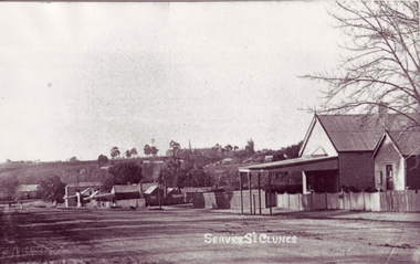
LAMINATED COPY OF PHOTOGRAPH OF SERVICE STREET, CLUNES.SERVICE ST. CLUNESlocal history, photography, photographs, clunes township -
 Clunes Museum
Photograph, REAL PHOTO SERIES M 2352
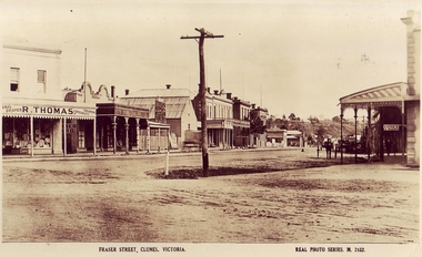
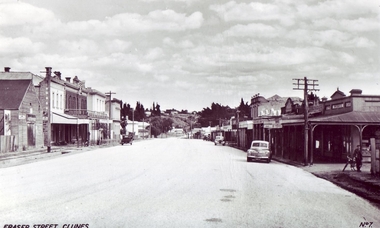
THE BUILDINGS IN THE PHOTOGRAPH INCL. R. THOMAS DRAPERY SHOP, DOUBLE STOREY CLUB HOTEL AND DOUBLE STOREY ORIGINAL BANK, NOW R.S.L BUILDING..1 POSTCARD OF CLUNES MAIN STREET. .2 COPY OF .1.1 ON REVERSE - PERSONAL NOTE TO KATIE FROM M C WEICKHARDT, ON FRONT FRASER STREET, CLUNES, VICTORIA REAL PHOTO SERIES M2352local history, photography, photographs, shops, r. thomas drapery, clunes township -
 Clunes Museum
Photograph
FRASER STREET CLUNES - GAS LIGHT IN MIDDLE OF STREET..1 .2 SEPIA POSTCARD PHOTOGRAPH OF UNION BANK- LATER A.N.Z. BANK AND NOW PRIVATE RESIDENCE. BALLARAT BAKERY WITH DECORATED VERANDAH OPPOSITE. FLAGS FLYING ON BUILDINGS. .3 BLACK AND WHITE COPY OF THE ABOVE PHOTOGRAPHphotography, shops -weickhardt's ballarat bakery, clunes township + buildings, bank union, anz -
 Clunes Museum
Photograph
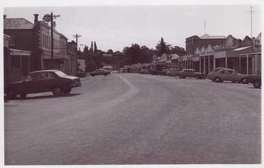
BUILDINGS INCL. NATIONAL HOTEL, CLUB HOTEL ETC.BLACK AND WHITE PHOTOGRAPH OF FRASER STREET, CLUNES.FRASER ST., CLUNES.photographs, national & club hotel, clunes township -
 Clunes Museum
Photograph, KODAK, 1942-52
CLUNES MAIN STREET, CAMP PARADE IN BACKGROUND..1 .2 BLACK AND WHITE POSTCARD PHOTOGRAPH OF FRASER STREET, CLUNES. CURRENT CLUNES MUSEUM ON LEFT WITH CLUB HOTEL AND OLD BANK BUILDINGS. CARS IN MAIN STREET. .3 BLACK AND WHITE COPY OF THE ABOVE PHOTOGRAPH PRINTED ON GLOSS PHOTOGRAPHIC PAPERphotographs, museum ect., clunes township -
 Clunes Museum
Photograph
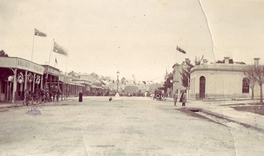
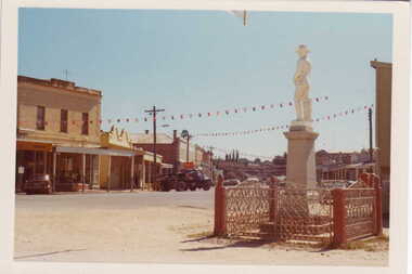
COLOURED PHOTOGRAPH OF CLUNES MAIN STREET, WITH BUILDINGS, PRESENT MUSEUM, CLUB HOTEL, OLD BANK BUILDINGS. FLAGS ACROSS THE STREET. SOLDIERS MONUMENT IN FOREGROUND.FRASER STREET, CLUNES WITH SOLDIERS MONUMENT.photographs, clunes township -
 Clunes Museum
Photograph, 1956
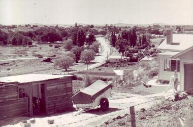
MR SWANTON'S HOUSE ON CAMP PARADE UNDER CONSTRUCTION.- VIEW OF FRASER STREET, CLUNES.BLACK AND WHITE PHOTOGRAPH OF CLUNES MAIN STREET. TAKEN FROM MR. SWANTON'S DRIVE.photographs, clunes township -
 Clunes Museum
Photograph
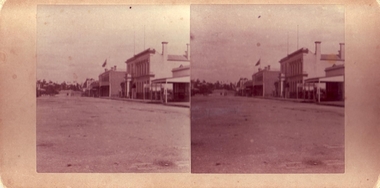
SEPIA PHOTOGRAPH OF FRASER STREET, CLUNES. SHOWING ES & ANZ BANK AND CLUB HOTEL. PHOTOGRAPH FOR USE ON A STEREOSCOPE.FRASER ST. CLUNES.photographs, clunes township -
 Clunes Museum
Photograph, CIRCA 1960
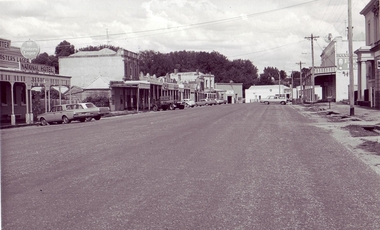
A VIEW OF CLUNES MAIN STREET [FRASER STREET] AND CAMP PARADE IN THE BACKGROUND.BLACK AND WHITE PHOTOGRAPH OF FRASER STREET, CLUNES. SHOWING MUSEUM ON LEFT HAND SIDE - CLUB HOTEL AND OLD BANKS ALSO FEATURED.local history, photography, photographs, clunes township -
 Clunes Museum
Photograph
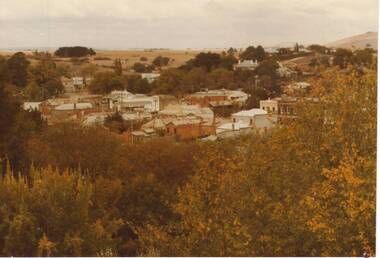
COLOURED PANORAMIC VIEW OF CLUNES TAKEN FROM SCENIC ROAD.local history, photography, photographs, clunes township -
 Nillumbik Shire Council
Painting: Walter WITHERS (b.1854 Warwickshire, UK — d.1914 Eltham, Aus), Trestle Bridge, Eltham, c.1903-10
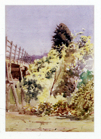
Walter Withers was a significant Australian landscape artist and a member of the Heidelberg School of Australian Impressionists. In 1903 Withers bought 'Southernwood', a house on 2½ acres (1 ha) at Eltham, to which he added a studio. Because of ill health, he lived during the week at his studio in Oxford Chambers, Melbourne, and on weekends and holidays with his family at Eltham until his death in 1914. The Eltham rail bridge is a unique and valuable historic relic of an earlier steam locomotive transport era in the Diamond Creek Valley and has long formed an important part of a magnificent Eltham landscape. When built in 1902 it was close to the terminus point of the Heidelberg-Eltham rail extension, on the route of the proposed Diamond Valley Railway that was then planned to continue much further up the valley towards Kinglake. This bridge is situated in attractive river-valley parkland amidst the tall and spreading manna gums and candlebarks of the Diamond Creek Valley. The Alistair Knox Park river-valley landscape, of which the timber trestle bridge is an important visual component, has been classified by the National Trust. Large manna gum and candlebark trees adorn the adjacent creek banks, and historic Shillinglaw Cottage is also part of this much-prized Eltham landscape. Eltham is home to a historic wooden railway trestle bridge. Mainly of timber-pier and timber-beam construction, but varied by a few longer steel-joists spans on timber piers at the main stream channel, this substantial bridge has almost two hundred metres of timber deck. Built in 1902, it is the only railway bridge of predominantly timber construction that is still in regular use as an integral part of Melbourne's metropolitan electric railway network and one of extremely few timber rail bridges in the State that still carry trains. Apart from its important continuing social function as a carrier of rail transport for the Hurstbridge line, this impressive bridge and its beautiful parkland environs contribute much to the character of Eltham township and that town's special reputation as an historic centre of environmental and conservation concerns. This section of the Diamond Creek Valley was the subject of a Walter Withers painting in the earliest years of the twentieth century and has strong historic links with our Heidelberg School of painters. Watercolour painting on paper of Eltham's Trestle Bridge in the middle of the day. A small section of the wooden bridge is located to the left of the painting. The focus is predominately on the wattle, manna gum and candlebark trees that is to the right of the bridge. The golden hues typically represent the australian sunlight and landscape. "W.W" in gothic script on the lower right side of the painting. Not dated. withers, eltham, trestle bridge, railway, watercolour -
 Peterborough History Group
Document - Survey of Town of Peterborough, 2014
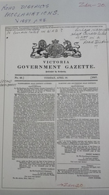
Proclamation of road district and Shires, Map of original town blocks and ad for SaleDisplays original township settlement and layoutPhotocopies, copies of maps, peterborough history, peterborough 3270 -
 Peterborough History Group
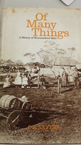
Book, C.E.Sayers, Of Many Things, 1972
Book contains information about early Peterborough: survey and settlers, schools and wrecks.Provides insight into the early formation of the township of Peterborough and its terrain.Hardcover 188 page book with indexInscription "donated by Barry Jenkins"peterborough history, irvine family, peterborough school, shipwrecks, shipwreck coast, great ocean road, warrnambool, peterborough shipwreck -
 Peterborough History Group
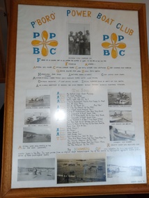
Memorabilia - P'boro' Power Boat Club, Wokker Moore, 1991
The Peterborough Power Boat Club was formed "on an indoors sort of day" during the summer of 1946/1947 in the bar of the old pub (The Peterborough Hotel). There was an annual race, which was a bit of fun, not a serious race. The race was called The Schomberg Cup (which then evolved into a golf tournament) and varied from a single unhandicapped lap around some marker buoys to the highest aggregate score from a series of three handicapped heats. The night before a Calcutta was held at the Hotel at which well dressed patrons all bet on the winning crew. The event ceased probably due to the aging of the main instigators.This is significant because it was a much anticipated annual event involving the whole township, anyone with a boat entered. Also, it somehow evolved into the annual golf tournament The Schomberg CupHandmade poster in a wooden frame which include text and photographspeterborough, schomberg cup, boat race, holiday activities, peterborough hotel, tinny grimwade, wokker moore, andrew chirnside, des moore -
 Whitehorse Historical Society Inc.
Document, Francom's Paddock Blackburn, 1914
Auction of 80 lotsAuction of 80 lots at Francom's Paddock, BlackburnAuction of 80 lotst. r. b morton & son, francoms paddock, blackburn road, blackburn, canterbury road, south parade, main street, myrtle grove, laurel grove, laburnum street, the avenue, fuchsia street, view street, linum street, kings paddock, blackburn township estate, gardenia street -
 Whitehorse Historical Society Inc.
Document - Leaflet, Blackburn Land Sale, 19/11/1910 12:00:00 AM
Pamphlets showing sale of land Gardenia Street, Blackburn and surrounding streets.Pamphlets showing sale of land Gardenia Street, Blackburn and surrounding streets. Schedule of prices. Hand drawn mapPamphlets showing sale of land Gardenia Street, Blackburn and surrounding streets.blackburn township estate co. ltd., blackburn railway station, south parade blackburn, laburnum street, blackburn, the avenue blackburn, fuschia street blackburn, linum street blackburn, main street, t.r.b.morton. & son, land subdivision -
Whitehorse Historical Society Inc.
Document, Particulars of Land Boom Companies
Research into Land Boom Companies by Keith PattersonResearch into Land Boom Companies by Keith PattersonResearch into Land Boom Companies by Keith Pattersonland subdivision, city investment and finance co ltd, standard property investment co ltd, freehold investment and banking company of australia ltd, commercial finance and property pty ltd, imperial finance and share company, east suburban property investment company, bay and mountain views company limited, east mitcham brick co ltd, imperial banking company, mitcham brick and pottery co ltd, davies, matthew henry, sir, morton, thomas richards burrowes., lachal, gustave, dow, john lamont, stamp, richard, bulmer, fink, theodore, munro & baillieu, mendell, george, fuller, arthur j, taylor, land discount and mortgage bank limited, blackburn township estate co ltd, springfield estate co ltd, royal land co ltd, gascoigne investment co ltd, tunstall brick and pottery company -
Whitehorse Historical Society Inc.
Document, Advance Blackburn
Copy of letter informing Blackburn residents of Nunawading Shire Council's grant of 75 pounds towards purchasing a block of land to run through from The Avenue to Blackburn Road and requesting donations from local residents.land subdivision, williams, e.g., page, chas. d, elmore, algernon john, shire of nunawading, the avenue, blackburn, blackburn road, south parade, francoms paddock, blackburn township estate, king's subdivision -
 Whitehorse Historical Society Inc.
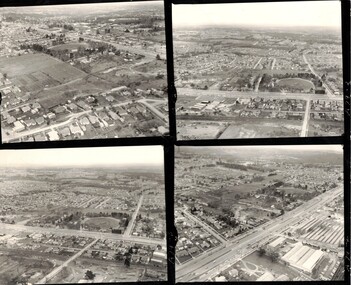
Photograph, Mitcham aerial photograph in the 1960's
Four black and white aerial photographs of Mitcham.mitcham township, aerial photographs -
 Rutherglen Historical Society
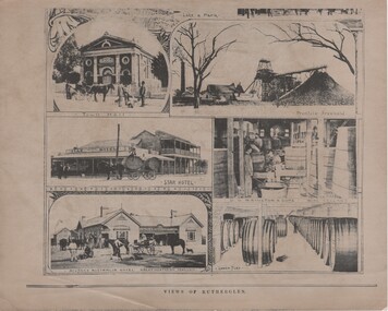
Newspaper - Image, The Leader, Views of Rutherglen, 21/04/1894
Date of issue confirmed on TROVE.Black and white photographic reproduction of an illustrations taken from the Leader, Saturday 21 April 1894, page 31 (bottom half of page).On back of photo: "The Leader, April 21 1894"main street, hotels, gold mines, rutherglen town hall, star hotel, d g hamilton, advance australia hotel, prentice freehold, wine cellars, great northern township -
 Ballarat Heritage Services
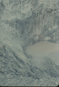
Slide, Dorothy Wickham, Matupi, Rabaul, Papua New Guinea, 1958
This photograph was taken before this volcano erupted and obliterated the Township of Rabaul, New Britain. On October 7, 2006, Rabaul Volcano on the northeastern tip of New Britain produced a large-scale eruption. According to ReliefWeb, the eruption shook windows and rained heavy ash and small stones on the city of Rabaul as authorities declared a state of emergency. See https://earthobservatory.nasa.gov/images/17486/eruption-from-rabaul-volcanoScanned from a coloured slideView from this sidematupi, rabaul, papua new guinea, crater, volcano -
 Ballarat Heritage Services
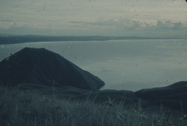
Slide, Dorothy Wickham, Matupi, Rabaul, Papua New Guinea, 1958
This photograph was taken before this volcano erupted and obliterated the Township of Rabaul, New Britain. On October 7, 2006, Rabaul Volcano on the northeastern tip of New Britain produced a large-scale eruption. According to ReliefWeb, the eruption shook windows and rained heavy ash and small stones on the city of Rabaul as authorities declared a state of emergency. See https://earthobservatory.nasa.gov/images/17486/eruption-from-rabaul-volcanoScanned from a coloured slideView from this sidematupi, rabaul, papua new guinea, crater, volcano -
 Ballarat Heritage Services
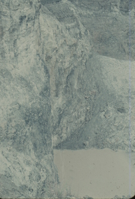
Slide, Dorothy Wickham, Matupi, Rabaul, Papua New Guinea, 1958
This photograph was taken around 1958 long before this volcano erupted and obliterated the Township of Rabaul, New Britain. On October 7, 2006, Rabaul Volcano on the northeastern tip of New Britain produced a large-scale eruption. According to ReliefWeb, the eruption shook windows and rained heavy ash and small stones on the city of Rabaul as authorities declared a state of emergency. See https://earthobservatory.nasa.gov/images/17486/eruption-from-rabaul-volcanoScanned from a coloured slideView from this sidematupi, rabaul, papua new guinea, volcano, island of new britain -
 Ballarat Heritage Services
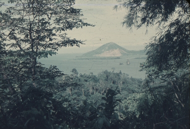
Slide, Dorothy Wickham, Matupi, Rabaul, Papua New Guinea, 1958
This photograph was taken around 1958 long before this volcano erupted and obliterated the Township of Rabaul, New Britain. On October 7, 2006, Rabaul Volcano on the northeastern tip of New Britain produced a large-scale eruption. According to ReliefWeb, the eruption shook windows and rained heavy ash and small stones on the city of Rabaul as authorities declared a state of emergency. See https://earthobservatory.nasa.gov/images/17486/eruption-from-rabaul-volcanoScanned from a coloured slideView from this sidematupi, rabaul, papua new guinea, volcano, island of new britain -
 Ballarat Heritage Services
Photograph - Digital photograph, Dorothy Wickham, Winter's Swamp, Ballarat, January to April 2014
Study of Winter's Swamp commissioned by BEN and completed by BHS. The swamp was named after one of the first European settlers in the district. Winter Swamp LAT -37 32 LONG 143 47, Parish of Dowling Forest, County of Grenville Winter Swamp, on the southwest corner of Ballarat West Town Common, was not included in the original proclamation of the Common in 1861. However, being marshland, it was not considered suitable for grazing, so was added to the Common soon after 1861. Winter Swamp is a large wetland with native and exotic pasture significant for wildlife. John Winter (Jock) was born in Berwickshire, Scotland. He married Janet Margaret Irving the daughter of Robert Irving, advocate, Bonshaw, Dumfries, Scotland. Winter died in Ballarat in 1875 and was buried at the Ballaarat Old Cemetery. He took up the run Bonshaw from 1841; Leigh River Buninyong 1842-46; Junction, Delatite, March 1851 to September 1862; with sons: Carag Carag and Corop, April 1857 to September 1872; Colbinabbin and Stewart’s Plains, April 1857 to December 1872; St Germains February 1867 to March 1871. (The name became Winter-Irving in 1890). Mr John Winter, who died on August 22 at the age of 72, was a man of some note it the mining community of Ballarat. He was a self-made man, and one of our oldest colonists, it being over a quarter of a century age since he took up county about Ballarat and settled at Bonshaw. He died very rich. It is calculated that if he had retained an interest in all his runs, his income must have been not less than £10,000 or £50,000 a year. Some eight or ten years ago he sold his Bonshaw pre-emption to the Bonshaw Gold mining Company for £20,000, and a few years later the ground belonging now to Winter's Freehold Company brought him £50,000 more, the payment being made at the requisition of the deceased in sovereigns. In these relations Mr. Winter has been closely identified with the mining industry at Ballarat. The deceased was a native of Lauder, in Berwickshire, and landed in Victoria several years before the gold discovery.The principle task of this project was the delivery of a report outlining the history of European settlement in the Skipton and Cardigan/Ballarat districts as pertinent to the use of and impact on the natural environment of the two reserves Skipton Common and Winter Swamp. The report was delivered in digital form only. The report, upon completion, was presented to the Network’s Committee in order to discuss the project. The report identified and described the uses of Skipton Common and Winter Swamp, and their impacts. In particular, this report examined farming/grazing (official and informal), mining, vegetation removal (including the removal of woodlands for timber, grasslands for pasture improvement) & use of riparian areas for access to water and timber removal. Recording the more benign and environmentally friendly uses such as picnicking, community activities, nature walks and the roles of organisations such as Field Naturalists’ and Bird Observers’ clubs, school and scout/guide groups will be relevant in helping to depict overall community attitudes towards the reserves; e.g.: has the Common generally been viewed as little more than a grazing paddock and fire hazard; has Winter Swamp always been the unknown natural asset that seems to have been its lot for at least the past 40 years? In this regard, the more contemporary history of actions surrounding the use and management of the reserves is of particular interest, in view of the extant evidence at both reserves; e.g. the actions of the Shire of Ballarat in the 1980s in establishing Winter Swamp as something of a competitor to Lake Wendouree but with a more environmental bent (although almost none of the plants used are indigenous species, but that is part of the story); the trotting track constructed on Skipton Common in the 1960s following representations to Premier Henry Bolte and the cropping of the western section of the Common to raise funds for the town’s new swimming pool, the fertilizing of the land putting an end to the native grassland vegetation. There are obviously multiple sources of information to source in preparing the report, however sources that the contractor is specifically requested to consult are the Skipton Historical Society, the former Skipton Common managers (specifically Graeme Pett), the Cardigan Windermere Landcare Group and the Learmonth Historical Society (believed to hold many of the former Shire of Ballarat’s records pertaining to the Council’s role as the Committee of Management for both Winter Swamp and the Ballarat West Town Common – Winter Swamp was split between 2 separate Crown Land tenures). The contractor is also encouraged but not required to utilise community newsletters, such as the Skipton Community Newsletter, to publicise and seek information about the project. Skipton Historical Society (Mary Bradshaw) contacted on Thursday 12 June 2.30pm. Mary lived on a farm out of Skipton but is currently living in the township. She remembers walking along the creek of the Common especially in spring and autumn in bare feet and that it was a very pretty place. There were a few snakes around the waterway in summer. People put cows and a couple of horses on the commonage to graze. Graeme Pett has always lived close to the Common and would know a lot about it. Other possible contacts would be Nicole Petress, Secretary of the Progress Association, and the Corangamite Council, Camperdown. Digital images of Winter's Swampwinter's swamp, ballarat, john winter, ballarat environmental network, mullawullah -
 Ballarat Heritage Services
Photograph - Digital photograph, Winter's Swamp surrounds, April 2014
The swamp was named after John (Jock) Winter. John Winter (Jock) was born in Berwickshire, Scotland. He married Janet Margaret Irving the daughter of Robert Irving, advocate, Bonshaw, Dumfries, Scotland. Winter died in Ballarat in 1875 and was buried at the Ballaarat Old Cemetery. He took up the run Bonshaw from 1841; Leigh River Buninyong 1842-46; Junction, Delatite, March 1851 to September 1862; with sons: Carag Carag and Corop, April 1857 to September 1872; Colbinabbin and Stewart’s Plains, April 1857 to December 1872; St Germains February 1867 to March 1871. (The name became Winter-Irving in 1890). Mr John Winter, who died on August 22 at the age of 72, was a man of some note it the mining community of Ballarat. He was a self-made man, and one of our oldest colonists, it being over a quarter of a century age since he took up county about Ballarat and settled at Bonshaw. He died very rich. It is calculated that if he had retained an interest in all his runs, his income must have been not less than £10,000 or £50,000 a year. Some eight or ten years ago he sold his Bonshaw pre-emption to the Bonshaw Gold mining Company for £20,000, and a few years later the ground belonging now to Winter's Freehold Company brought him £50,000 more, the payment being made at the requisition of the deceased in sovereigns. In these relations Mr. Winter has been closely identified with the mining industry at Ballarat. The deceased was a native of Lauder, in Berwickshire, and landed in Victoria several years before the gold discovery. BHS were commissioned by Ballarat Environment Network for a project on Winter's Swamp and Skipton Common. Winter's Swamp was part of Ballarat West Common. The principle task of this project was the delivery of a report outlining the history of European settlement in the Skipton and Cardigan/Ballarat districts as pertinent to the use of and impact on the natural environment of the two reserves Skipton Common and Winter Swamp. The report was delivered in digital form only. The report, upon completion, was presented to the Network’s Committee in order to discuss the project. The report identified and described the uses of Skipton Common and Winter Swamp, and their impacts. In particular, this report examined farming/grazing (official and informal), mining, vegetation removal (including the removal of woodlands for timber, grasslands for pasture improvement) & use of riparian areas for access to water and timber removal. Recording the more benign and environmentally friendly uses such as picnicking, community activities, nature walks and the roles of organisations such as Field Naturalists’ and Bird Observers’ clubs, school and scout/guide groups will be relevant in helping to depict overall community attitudes towards the reserves; e.g.: has the Common generally been viewed as little more than a grazing paddock and fire hazard; has Winter Swamp always been the unknown natural asset that seems to have been its lot for at least the past 40 years? In this regard, the more contemporary history of actions surrounding the use and management of the reserves is of particular interest, in view of the extant evidence at both reserves; e.g. the actions of the Shire of Ballarat in the 1980s in establishing Winter Swamp as something of a competitor to Lake Wendouree but with a more environmental bent (although almost none of the plants used are indigenous species, but that is part of the story); the trotting track constructed on Skipton Common in the 1960s following representations to Premier Henry Bolte and the cropping of the western section of the Common to raise funds for the town’s new swimming pool, the fertilizing of the land putting an end to the native grassland vegetation. There are obviously multiple sources of information to source in preparing the report, however sources that the contractor is specifically requested to consult are the Skipton Historical Society, the former Skipton Common managers (specifically Graeme Pett), the Cardigan Windermere Landcare Group and the Learmonth Historical Society (believed to hold many of the former Shire of Ballarat’s records pertaining to the Council’s role as the Committee of Management for both Winter Swamp and the Ballarat West Town Common – Winter Swamp was split between 2 separate Crown Land tenures). The contractor is also encouraged but not required to utilise community newsletters, such as the Skipton Community Newsletter, to publicise and seek information about the project. Skipton Historical Society (Mary Bradshaw) contacted on Thursday 12 June 2.30pm. Mary lived on a farm out of Skipton but is currently living in the township. She remembers walking along the creek of the Common especially in spring and autumn in bare feet and that it was a very pretty place. There were a few snakes around the waterway in summer. People put cows and a couple of horses on the commonage to graze. Graeme Pett has always lived close to the Common and would know a lot about it. Other possible contacts would be Nicole Petress, Secretary of the Progress Association, and the Corangamite Council, Camperdown. Mary can’t remember any photos in the Skipton Historical Society that pertain to the Common. Digital photos of Winter's swamp surrounds, later known as Mullawullah.winter, winter's swamp surrounds, winter's swap, john winter, ballarat environmental network, ballarat, mullawullah -
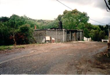 Hume City Civic Collection
Phortograph, 1989
The building is the former Bulla Post Office and general store which was damaged by fire in 1989 and never rebuilt. A private house now occupies the site. The post office was relocated to a service station about 1km away. For many years the former Bulla Post Office and store was the focal point in the small township.A coloured photograph of a bluestone building by a roadside which has been gutted by fire. There is no roof but the chimney is intact. -
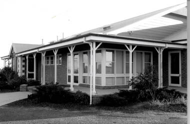 Hume City Civic Collection
Photograph, Bulla Community Centre, c1980s
The building is the Bulla Community Centre, which replaced an older hall that was situated in the Bulla Sports Ground precinct in Greene Street. Over the years many community activities have been staged within the precinct such as district school sports, local dances and community social group functions.A black and white photograph of a brick building with large windows and a return verandah.bulla community centre, bulla township -
Hume City Civic Collection
Photograph, Bulla Shire Hall
The building in the image was the original Shire of Bulla council offices where councillors met until 1901 when they relocated to Sunbury and conducted their meetings in the Mechanics Institute Hall later known as the Memorial Hall.This building was originally the offices for the Bulla Roads Board and was the first council office built in the bulla shire'A photocopy of a non digital black and white photograph with a cream border of a historic bluestone building.council offices, bulla bulla township, bulla shire hall, bulla shire council, councillors, bluestone -
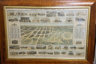 Numurkah & District Historical Society
Map - Print in frame - Numurkah Township 1888, Supplement to the "Numurkah Standard" January 1888 View of Numurkah Victoria Australia
The late Hilda Morieson (very active in early Historical Society) owned the print. It was then passed on to Mary Morieson, then to Rosemary Kennet. It has been passed onto the Historical Society with permission from Ben Morieson, Hilda's grandsonLarge coloured print of supplement to Numurkah Standard 1888. Artist's view/impression of Numurkah streets (map) surrounded by artwork of a number of Numurkah businesses in the town and local district. The print is under glass in a faux-wood-grained framesee photo abovenumurkah standard, numurkah township map, numurkah businesses, 1888, print