Showing 123961 items
matching main-road
-
 Whitehorse Historical Society Inc.
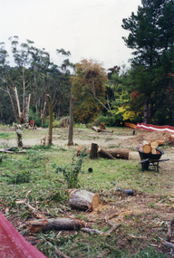
Photograph, Deep Creek Road, 1/04/2001 12:00:00 AM
Coloured photograph looking from footpath East side of Deep Creek Road at start of construction of new Bridge.deep creek road, mitcham -
 Pyrenees Shire Council
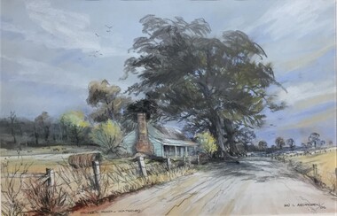
painting, Ian L Anderson, School Road, Waterloo by Ian L Anderson, 1995
significant as a work of art by local Pyrenees artist, locally significant to the Central Highlands Region of Victoria as a representation of local landscape and/or culture pastel drawing of a street scene with old house, trees and unpaved road"Signed: IAN L ANDERSON 95 (lower right) Titled: SCHOOL ROAD - WATERLOO (lower centre) Verso (affixed): ""SCHOOL ROAD - WATERLOO"" PASTEL AND CHARCOAL PENCIL PAINTING by IAN L. ANDERSON 14 MILLAR CRESCENT MT WAVERLEY 3145 signed: Ian Anderson '95 $500" -
 Stawell Historical Society Inc
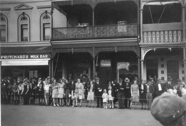
Photograph, Crowd lining up in the Main Street near Town Hall Hotel c1940's
Photo of crowd lining up in front of Main Street Stawell buildings near Town Hall Hotel. Prichard's Milk Bar. Taylor Draper. Town Hall Hotel. c1940's. The two story building in the center was once owned by W. Whiteside, Taylors and the Prichard's milk bar once owned by Bone, Saddler & Harness Factory. Sepia photograph of Crowd lining Main Street Stawell in the 1940's. The crowd is outside a two story building with an ornate balcony and between Prichard's Milk Bar and the Town Hall Hotel. Two people are leaning on the upstairs balcony. The crowd are all looking to the right and consist of a mixture of young and older people. Prichard's Milk Bar on one building. Taylor and Draper on another.stawell business, streetscape -
 Surrey Hills Historical Society Collection
Photograph, Grovedale Road Quarry in the 1920s - looking south, c1920
The quarry was part of John Butler Maling's property. He was one of the original settlers of the area and farmed the area between Weybridge Street and Whitehorse Road. Clay was quarried from part of this area and used to make the bricks used in the construction of his home, known as 'Ancyra'. This is still extant at the corner of Weybridge and James Streets. Maling grazed cows and used the quarry as a water source. He was the uncle of John Butler Maling, Mayor of Camberwell. He was married to Kate Conlon in 1882. They had 3 children: Silas Young, Alick and Zillah. Maling was born in c1829 in Shepreth, Cambridgeshire; he died in Surrey Hills on 9 October 1912 and is buried in Box Hill Cemetery - CE-*-0586. Mrs Kate Maling (born c1859 in Co Meath, Ireland) died at the property on 8 March 1921. She is buried in Brighton General Cemetery. Probate was valued at over 10,000 pounds and included other properties in Sandringham, Hawthorn and Macedon. At the time of her death the Surrey Hills property was described as being 23 acres with 2 brick houses, 1 cow, 2 heifers and 40 fowls or chickens. The property was subdivided after her death. The property was subdivided into 110 house blocks in c1923 - see Maling's Estate subdivision flyer on the State Library of Victoria's website. This shows that the Grovedale Park site had been acquired by Camberwell Council by this time. An attached newspaper clipping documents prices realised for a cross-section of blocks. The MMBW map of 1925, also on the SLV website, shows the outline of the clayhole / quarry. The quarry was filled in after several drownings or near drownings and the land is now occupied by a park and playground, known as Grovedale Road Park, maintained by the City of Boroondara. Beckett Park is sited on horizon to the left beyond the trees. This documents the landscape prior to close settlement and is material to early building and farming in the Surrey Hills area.Black and white photo of the quarry between Grovedale Road and James Street taken in the 1920s and looking south. In the foreground is an area of water with reeds in the LH corner. Beyond on the high banks there are single storey houses in the background and (?) some light poles. An object that looks like a tank on posts is in a cutting on the far bank.quarries, grovedale road, james street, clay quarries, farming, kate conlon, kate maling, john butler maling, ancyra -
 Stawell Historical Society Inc
Photograph, Main Street Stawell taken from front of Town Hall and Lower Main Street
Two photographs of Main Street Stawell Scenes - Set in Australia Shape. Main Street taken from front of Town Hall and Lower Main Street stawell streetscape -
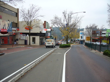
 Whitehorse Historical Society Inc.
Photograph - Strip photo/ photocopy, Railway Road Blackburn
East end of Railway Road Blackburn August 1996.Railway Road East end Blackburnrailway road, blackburn, 1976 -
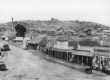 Stawell Historical Society Inc
Photograph, Streetscape of South side of Upper Main Street Reefs Stawell looking East from around Patrick Street corner with Big Hill Mining in background c 1867
Upper Main Street east of Patrick street, looking East c 1867 with Big Hill Mining in Background. J McGee's Shamrock Hotel. Jennings Western Turf Hotel. R Lorimer & Co. Photo c 1867 McGees Shamrock Hotel centre. R. Williams Dining Rooms,. Jennings's Western Turf Hotel situated in upper Main Street (Opposite Monaghan's Estate Office) Mr. George Jennings was proprietor until the late 1860's when he went to live at "Mayo Park" Lubek. The Hotel had Various owners until it was delicensed in 1909 and became a boarding house. It was demolished in 1921. R. Lorimer & Co general Store near corner of Patrick Street.Streetscape of South Side of Main Street East of Patrick Street. Two wagons in street. Showing J. McGees Shamrock Hotel, R Williams Dining Rooms, Jennings's Western Turf Hotel and R. Lorimer & Co. Mine Engine Chimney is on left of photo. Big Hill in Background with Waterloo Reef Company Whim at centre.stawell streetscape -
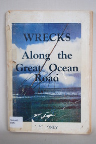 Anglesea and District Historical Society
Book, J Loney, Wrecks Along the Great Ocean Road, 1967
Book first published in 1967 dealing with the shipwrecks along the Great Ocean Road. Illustrated with both maps and photographs and with a chrononolgy of the list of wrecks from pre-1800 through to 1958.Title: WRECKS / Along the / Great Ocean / Road J.K. LONEYjack loney, dewey no 910.453, book -
 Whitehorse Historical Society Inc.
Map, Nunawading Road District, 01/04/1863
Plan of proposed new road - April 1863 & estimated expenses.Plan of proposed new road - April 1863 & estimated expenses. Scale 20 chains per inch. Proclaimed Roads 149.Plan of proposed new road - April 1863 & estimated expenses.nunawading road district, roads and streets -
 Eltham District Historical Society Inc
Photograph, Michael Wood, Houses on Progress Road viewed from Glen Park Road, Eltham North, February 1970, 1970
Wood family home (1969-2011) pre and post construction by Knox and Hellemons Shows Wood family home on Progress Road in centre of field of viewKodachrome 35mm colour transparency in cardboard mount Processing date FEB70M6Inscribed in ink "Hoses on Progress Rd from Glen Park Rd, Eltham North 1970"alistair knox design, eltham north, hellemon, houses, progress road, glen park road -
 Greensborough Historical Society
Photograph - Photograph - Digital Image, Main Street bridge Greensborough 1970s, 1970s
A colour photograph of the corner of Para Road and Main Street Greensborough in the 1970s, during the duplication and construction of the bridge over the Plenty River.Digital copy of colour photograph.main street greensborough, para road greensborough, plenty river bridge -
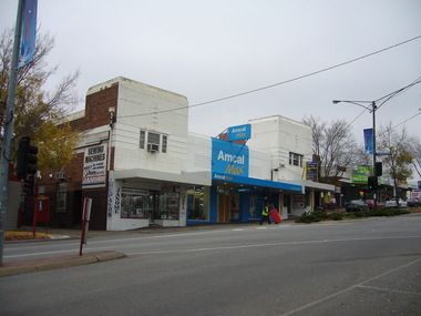
 Greensborough Historical Society
Photograph - Digital image, Noel Withers, Main Street Greensborough, looking North 2010, 04/06/2010
View of Main Street Greensborough near Para Road, looking North. Photograph taken by GHS member Noel Withers in 2010.Digital copy of colour photograph.main street greensborough, para road -
 Greensborough Historical Society
Photograph - Digital image, Noel Withers, Main Street looking east, 2010, 04/06/2010
View of Main Street Greensborough, near Para Road, looking East. Photograph taken by GHS member Noel Withers, 2010.Digital copy of colour photograph.main street greensborough, para road -
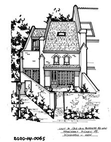 Hawthorn Historical Society
Drawing - Property Illustration, 3/312-316 Barkers Road, Hawthorn
'After training as a Cartographic Draftsman within the mining industry, I worked as a property illustrator for real estate firms in the eastern suburbs of Melbourne for 23 years from 1983. I initially photographed houses with a Polaroid camera and made a 'thumbnail' sketch while there. The photos were used to scale off a sketch in pencil and then that sketch was overlaid with drafting film and the 'pen and ink' completed. The pens I used were the Rotring ‘Rapidigraph’ drafting pens. The ink was also made by Rotring (German).The film was ‘Rapidraw’, polyester drafting film, double matte. It takes a very fine line and doesn’t bleed. As well as house sketches, there were often floor plans and site plans ordered. Aerial sketches were ordered when the property needed an overall view.' (Margaret Picken, 2020)This property illustration is one of a series created by Margaret Picken for a range of real estate agents in Melbourne between c. 1983 and c. 2006. Each work is signed and dated by the artist.Gift of Margaret Picken, 2020Pen and ink property illustration on drafting film of 3/312-316 Barkers Road, Hawthorn by Margaret Picken.Unit 3/312-316 Barkers Road, Haw, Margaret Picken '89. Woodards - Kew.artist - margaret picken 1950- -
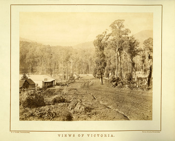 Marysville & District Historical Society
Photograph (Item) - Black and white photograph, Nicholas John Caire, Views of Victoria, Unknown
An early black and white photograph of the main road in Marysville in Victoria taken by Nicholas John Caire.An early black and white photograph of the main road in Marysville in Victoria showing the Keppels Australian Hotel which was built and opened by the Keppel Family in 1865. The Keppels Australian Hotel was the first hotel to be opened in Marysville. The Keppel Family were among Marysville's earliest pioneering families. This photograph was taken by Nicholas John Caire. N.J. Caire had a great love for the area in and surrounding Marysville and in the late 1800's took many photographs of Marysville and its surrounds. N.J. Caire was born in 1837 in Guernsey. He arrived in Adelaide about 1860 along with his parents who encouraged his early interest in photography. He opened a studio in Adelaide in 1867 after traveling extensively throughout the Gippsland taking photographs. After marrying in 1870 he moved to Talbot in Victoria until 1876 when he opened a studio in the Royal Arcade in Melbourne. After 1885 N.J. Caire gave up his city work and made his home in South Yarra and devoted the rest of his life to outdoor photography, specializing in the bush, the gullies and the mountains of south-eastern Victoria. N.J. CAIRE, PHOTOGRAPHER ROYAL ARCADE, MELBOURNEmarysville, victoria, keppels australian hotel, keppel family, nicholas john caire, photograph -
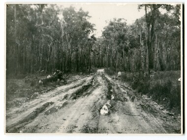 Orbost & District Historical Society
black and white photograph, 1924
This photograph shows the main road near Bellbird, East Gippsland, in 1924. This road would have been the Princes Highway, a main thoroughfare through to New South Wales. Bellbird Creek is a small rural location between Orbost and Cann River. There was no township at Cabbage Tree at this time. The Cabbage Tree Creek township was established to support the booming timber industry of the mid 20th century. Five timber mills worked full time supporting the families that were drawn to the area's wealth of natural resources. Nestled on the banks of the Cabbage Tree Creek, the township was built by those mills to house their workers. Today although the timber mills have disappeared, some of the buildings still remain. Little now remains to remind of the saw-milling history apart from photographs and some relics - a boiler and a brick furnace. There was also a thriving agricultural community farming dairy, beef, seed beans and fresh peas and beans that were sent to the Victoria Market in Melbourne. Dairy farming still plays an essential role in the township. this is a pictorial record of the Princes Highway, the main road from East Gippsland to the New South Wales border.A large black / white photograph of a very wet and boggy bush road.on front - "Main Rd near Bellbird 1924"road princes-highway bellbird-creek-1924 -
 Stawell Historical Society Inc
Photograph, Stawell Main Street Shops from the Anglican Church to Upper Main Street 1998 -- 45 Photos
Main Street Shops Anglican Church to Upper Main Street - 1998Anglican Church , Tubs Video Shop, BRACE Employment Services Pykes Cycles and Sports, Site of R.J. McClure garage, Stawell Town Hall, Methodist Chruch Wesley Centre, Tonkin Motors Holden dealership, Stawell Taxis, Ivan McDonald hairdresser, Holmes Fruiter, Pamala's Hairdresser, Bakery, Stawell Post Office, Fish and Chip Shop, Denis Weily Chemist, Gold Reef Clothing, Overalls Furniture, Commonwealth Bank (State Bank), Stawell Tattslotto, W.P Computers, Pioneer Walk 4 Photos, Site of Max Holme Butcher, Hardings Mensland, Coles/ Fosseys both buildings, George Wilkinson Dentist, Betta Electrics, Gold Reef photgraphics, General Office of N.G.S.C. Classic Shoes, Old Commonwealth Bank, Stawell Club, Cafe Rasuli, Albion Hotel Then Retravision, Fountain, Newton Bros Buther 3 Photos 2 fron one rear, A.N.Z. Bank two views, Stawell Dry Cleaners, Fuller's Insurane Brokers, Reg Seng Pha Solicitor 2 views 1 B/W, Grampian China Art, Clarks Furniture, Unkonown 2 views, Commercial Hotel, O,Driscoll Solicitors, Auto Pro, Chinese Medicine, Westfarmers Dalgety Real Estate, Monaghan's Real Estate, BRACE Employment Services, James Monaghan Solicitor, Stawell Electronics, Old Ambulance Station.stawell -
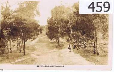 Greensborough Historical Society
Postcard, The Rose Stereographs, Britnell Road, Greensborough, 1920s
This postcard shows us what Britnells Road (now Mountainview Road) looked like in the WW1 era. Britnell Road is a former name of the Mountain View Road section between St Helena Rd and Sherbourne Rodd.A sepia toned postcard featuring a photograph of a rural road scene.2 photo mount remains on rear, nil on front.britnell road, greensborough, mountain view road. -
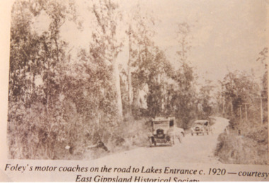 Lakes Entrance Historical Society
Photograph, Foleys motor coaches on the road to Lakes Entrance, 1920 c
Sepia toned photograph showing Foleys motor coaches on road to Lakes Entrance possibly near Bennetts Brook, coach and trailer in front A Ford and trailer behind, tall trees on either side of road, telephone poles on right side. East Gippsland VictoriaFoleys motor coaches on the road to Lakes Entrance c 1920 Courtesy East Gippsland Historical Societytransport -
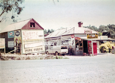 Eltham District Historical Society Inc
Photograph, Doney's General Store, Research, c.1969
Roadside buildings, formerly Doney's General Store. Doney's operated from the 1880s through to the late 1960s. It was situated at the head of the present day Research shops on Main Road near the corner of Raglan Road. By the 1960s it was under new ownership. The Store had a residence at the back. Signs promote The Herald and Sun newspapers, four 'n twenty pies, coca cola and more. A public phone box is in the front of the store. Beside the store is possibly an old farm building with more signs advertising honey, Streets, Tarax and a local bottle dump. Lyn Dodkins used to work in the Store after school.Digital file onlygeneral store, research (vic.), milkbar, lyn dodkins -
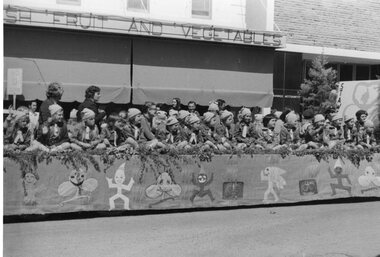 Stawell Historical Society Inc
Photograph, Stawell Brownies on float in Main Street
Brownies and leaders on float in Main Street in front of Fresh Fruit and Vegetables shopStawell Brownies Float entered in procession M Huttonguides -
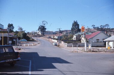 Stawell Historical Society Inc
photograph - Slide, Ian McCann, Main Street & Patrick Street Looking towards Big Hill, 1976 - 1984
Colour Photograph of Main and Patrick Street Intersection looking towards Big Hill -
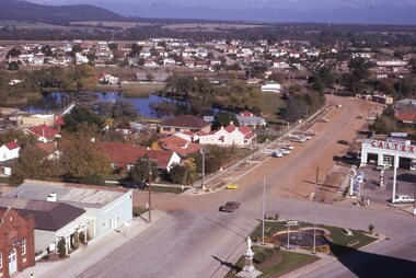 Stawell Historical Society Inc
photograph - Slides, Ian McCann, Main Street, Victoria Steet, Looking towards the Grampians, 1976 - 1984
Colour Photograph showing Main Street and Victoria Street with Cato Lake in background -
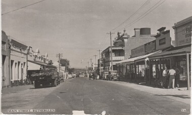 Rutherglen Historical Society
Post card, Main Street, Rutherglen, 1930s
Black and white postcard photograph showing Main Street, Rutherglen looking eastmain street rutherglen, victoria hotel -
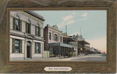 Rutherglen Historical Society
Image, Main Street, Rutherglen, 1911 to 1916
Post card sized coloured photograph of Main Street Rutherglen, looking west. main street rutherglen, bank of australasia, victoria hotel, s younkman & co -
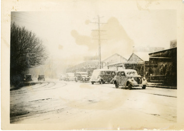 Mt Dandenong & District Historical Society Inc.
Photograph, Snow Scene Main Street Olinda c1950, c1950
Cars and small bus in Main Street Olinda during heavy snow c1950.snow, olinda, main street, cars -
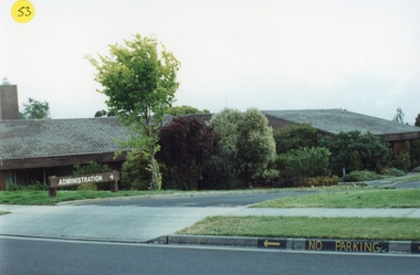 Department of Health and Human Services
Photograph, Colanda Grounds - Exterior of Administration from main driveway
The Colac, Victoria-based Colanda Centre was one of the last Victorian institutions and offered disability accommodation from 1976, when it was established, until 2019, with its closure.Digitised colour photograph of the exterior of Colanda's administration building from the main driveway. colanda, colac, disability services, residential services, disability, digitised photograph -
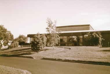 Department of Health and Human Services
Photograph, Colanda Grounds - Main Kitchen - Staff Cafeteria
The Colac, Victoria-based Colanda Centre was one of the last Victorian institutions and offered disability accommodation from 1976, when it was established, until 2019, with its closure.Digitised colour photograph of the Colanda Centre main kitchen and staff cafeteria buildings. colanda, colac, disability services, residential services, disability, digitised photograph -
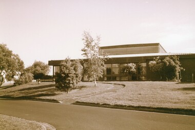 Department of Health and Human Services
Photograph, Colanda Grounds - Main Kitchen - Staff Cafeteria
The Colac, Victoria-based Colanda Centre was one of the last Victorian institutions and offered disability accommodation from 1976, when it was established, until 2019, with its closure.Digitised colour photograph of the Colanda Centre main kitchen and staff cafateria buildings. colanda, colac, disability services, residential services, disability, digitised photograph -
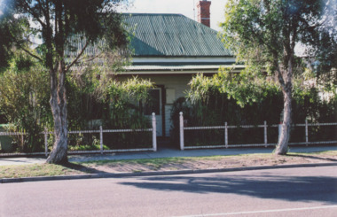 Lakes Entrance Historical Society
Photograph - Bruthen Cottage Hospital Main Street Bruthen Victoria, M Holding, 1/07/2009 12:00:00 AM
This building is now a private home.Colour photograph of old Bruthen Cottage Hospital Main Street Bruthen Victoriaaccommodation