Showing 13591 items
matching wye-river-bridge
-
 Eltham District Historical Society Inc
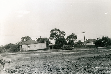
Photograph, Sherbourne Road, Para Road and Simms Road at Briar Hill/Montmorency prior to the upgrade of Sherbourne Road Railway bridge, c.1970
Collection of photographs probably taken around the same time depicting Sherbourne Road, Para Road and Simms Road at Briar Hill/Montmorency prior to the upgrade of Sherbourne Road Railway bridge, c.1970. Photo 01648_ 19 This home owned by Mrs Cameron. Her daughter married a Mr Davey, for whom Davey Road was named - email from M. Jones 20/07/2015 Photographer unknownThese photos are very significant in the documentation of the development of the Briar Hill and Montmorency areas and the changes in the physical landscape along the railway line area.20 black and white prints 9 cm x 13 cm.1970, briar hill, davey road, montmorency, para road, cameron, davey, sherbourne road, simms road, railway line, roadworks -
 Eltham District Historical Society Inc
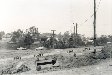
Photograph, Sherbourne Road, Para Road and Simms Road at Briar Hill/Montmorency prior to the upgrade of Sherbourne Road Railway bridge, c.1970
Collection of photographs probably taken around the same time depicting Sherbourne Road, Para Road and Simms Road at Briar Hill/Montmorency prior to the upgrade of Sherbourne Road Railway bridge, c.1970. Photo 01648_ 19 This home owned by Mrs Cameron. Her daughter married a Mr Davey, for whom Davey Road was named - email from M. Jones 20/07/2015 Photographer unknownThese photos are very significant in the documentation of the development of the Briar Hill and Montmorency areas and the changes in the physical landscape along the railway line area.20 black and white prints 9 cm x 13 cm.1970, briar hill, davey road, montmorency, para road, cameron, davey, sherbourne road, simms road, railway line, roadworks -
 Eltham District Historical Society Inc
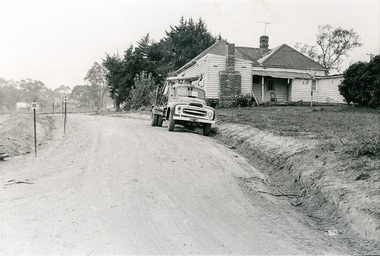
Photograph, Sherbourne Road, Para Road and Simms Road at Briar Hill/Montmorency prior to the upgrade of Sherbourne Road Railway bridge, c.1970
Collection of photographs probably taken around the same time depicting Sherbourne Road, Para Road and Simms Road at Briar Hill/Montmorency prior to the upgrade of Sherbourne Road Railway bridge, c.1970. Photo 01648_ 19 This home owned by Mrs Cameron. Her daughter married a Mr Davey, for whom Davey Road was named - email from M. Jones 20/07/2015 Photographer unknownThese photos are very significant in the documentation of the development of the Briar Hill and Montmorency areas and the changes in the physical landscape along the railway line area.20 black and white prints 9 cm x 13 cm.1970, briar hill, davey road, montmorency, para road, cameron, davey, sherbourne road, simms road, railway line, roadworks -
 Eltham District Historical Society Inc
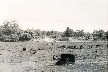
Photograph, Sherbourne Road, Para Road and Simms Road at Briar Hill/Montmorency prior to the upgrade of Sherbourne Road Railway bridge, c.1970
Collection of photographs probably taken around the same time depicting Sherbourne Road, Para Road and Simms Road at Briar Hill/Montmorency prior to the upgrade of Sherbourne Road Railway bridge, c.1970. Photo 01648_ 19 This home owned by Mrs Cameron. Her daughter married a Mr Davey, for whom Davey Road was named - email from M. Jones 20/07/2015 Photographer unknownThese photos are very significant in the documentation of the development of the Briar Hill and Montmorency areas and the changes in the physical landscape along the railway line area.20 black and white prints 9 cm x 13 cm.1970, briar hill, davey road, montmorency, para road, cameron, davey, sherbourne road, simms road, railway line, roadworks -
 Eltham District Historical Society Inc
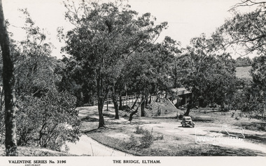
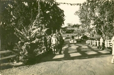
Postcard - Photograph, The Rose Stereograph Company, The Bridge, Eltham, c.1939
Looking west across the Main Road Bridge over the Diamond Creek at Eltham, c.1939. The car in the foreground, possibly the photographer's, is a Ford Model C Ten built by Ford UK between 1934 and 1937. The Model C was released in Australia in 1935. The Ford Model C Ten is a car that was built by Ford UK between 1934 and 1937. The Model C was released in Australia in 1935 https://en.wikipedia.org/wiki/Ford_Model_C_TenPostcardValentine Series No.3196diamond creek (creek), ford model c ten, main road bridge, postcard, valentine series postcard, bridge, cars, eltham, eltham south, main road, motor vehicles, rose stereograph, rose stereograph company -
 Eltham District Historical Society Inc
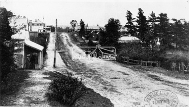
Photograph, View in Eltham looking south along Main road from Bridge Street, 1902
Looking south along Main Road from the south side of the intersection of Bridge Street with Main Road. Post Office (Anne Hunniford Postmistress) on left then the Commercial Bank of Australasia building. The house on the right, 'Derril,' was purchased by Walter Gahan in 1924 and was demolished in 1968 when Main Road was widened. In the distance on the left is Watson's Hotel and on the right (opposite side of the main road, Morris's Hotel Cross Ref: 0624This photo forms part of a collection of photographs gathered by the Shire of Eltham for their centenary project book,"Pioneers and Painters: 100 years of the Shire of Eltham" by Alan Marshall (1971). The collection of over 500 images is held in partnership between Eltham District Historical Society and Yarra Plenty Regional Library (Eltham Library) and is now formally known as the 'The Shire of Eltham Pioneers Photograph Collection.' It is significant in being the first community sourced collection representing the places and people of the Shire's first one hundred years.Digital image Print 14 x 24 cm 35 mm B&W negativeanne jane hunniford (1855-1928), bridge street, commercial bank of australia, derril, eltham, gahan house, main road, morris's hotel, post office, shire of eltham pioneers photograph collection, watsons hotel -
 Clunes Museum
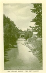
Photograph, AJAX SERIES
PRODUCED IN VICTORIACOPY OF PHOTOGRAPH OF CLUNES CREEK - BLUESTONE "GOVERNMENT" BRIDGE IN THE BACKGROUND, SMALL HUT ON RIGHT HAND BANK OF CREEK.THE CLUNES CREEK - THE NEW BRIDGElocal history, document, postcard, bridges -
 Melbourne Tram Museum
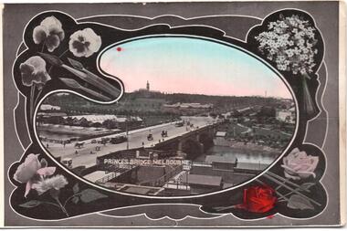
Postcard, SEMCO, "Princes Bridge Melbourne", mid 1900's?
Divided back postcard featuring a hand coloured black and white photograph of a view looking from Flinders St towards Government House, c1900, or from the roof of the Flinders St Station which could be under construction. Embossed Photograph enclosed within an artists palette, surrounded by roses. Note the buildings between the bridge and Government house - a former asylum? Card from the SEMCO Series Box 545 GPO Melbourne. Addressed to Miss V Hall of Blackwood.trams, tramways, princes bridge, cable trams, flinders st, flinders st station -
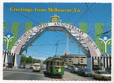 Melbourne Tram Museum
Postcard, Biscay Greetings, W2 601, passing under the 150th Victorian Anniversary arch on Princes Bridge, 1984/85
Colour postcard divided back, serrated edges - Biscay Greetings, series of featuring W2 601, passing under the 150th Victorian Anniversary arch on Princes Bridge during 1984 or 1985. Has the Arts Centre in the background. Tram has the destination of Glen Iris, Route 6. Back has space for name and address, stamp and a message and details of the postcard. Produced by Biscay Greetings, possibly mid to late 1980's. Card No. BG200. Two copies held.trams, tramways, princes bridge, 150th anniversary victoria, w2 class, ceremonies, route 6, tram 601 -
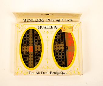 Stanley Athenaeum & Public Room
Leisure object - Euchre Cards - Hustler
Hustler brand. Double deck Bridge set. Plastic coated.Hustler/Double Deck Bridge set. Coles sticker. -
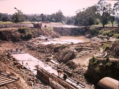 Kew Historical Society Inc
Photograph - Construction of the Eastern Freeway (F19), Ron Setford, March 1972
Ron Setford and his wife Grace Setford lived in Tanner Avenue, East Kew, from c.1946 to c.1995. A keen photographer, he recorded the changing face of Kew over a 20 year period. Apart from 30 photographs of built structures and places in Kew dating from 1960 and 1961, 145 of his 35mm colour slides chronicle the development of the F19 (later renamed Eastern) Freeway through the Yarra Valley in Kew over a five year period from c.1972 to c.1977. This important collection was donated to the Society by his granddaughter in 2025.This collection of 175 35mm slides is of local and statewide significance, owing to its subject matter, particularly the major development of road transport infrastructure during the 1970s with the construction of the Eastern Freeway. The photographer also took care to annotate and date most of his slides which enable the researcher to pinpoint temporal and spatial locations.Photograph of works involved in construction of the F19 (now Eastern) Freeway. The photo shows the old river bed of the Yarra and work to alter the Kew Main Drain where it originally entered the river. "Eastern Freeway / Old River Bed / Alterations to Kew S/water Drain"ron setford, eastern freeway, f19 freeway -
 Glenelg Shire Council Cultural Collection
Photograph - Photograph - Canal Bridge Construction, n.d
Port of Portland Authority ArchivesFront: Back- 'Clift Street Bridge' - top left, black biro Purple csiro stamp.port of portland archives -
 Eltham District Historical Society Inc
Negative - Photograph, Rose Stereograph Company, The Bridge, Hurstbridge, Vic, c.1925
Copied from brochure "Wattle Valley Estate". The new bridge designed by Sir John Monash over the Diamond Creek near Hurst's original home "Mia Mia" seen in the distance. Reprinted from brochure advertising "Wattle Valley Estate" 7 minutes from bridge. The Wattle Valley Estate was first advertised in August 1925 as weekend building allotments by the Greater Melbourne Land and Development Company. Advertised from £28.10.0 or £60 per block. In August 1926, 30 picked allotments of 60x150 feet were put up for auction Saturday August 14, 1926 with frontages to Valley View Road and Fawkner Crescent advertised in the “Heart of the Glorious Wattle Country” and “Within 15 Minutes of the Newly Electrified Railway Station”. The Advertiser on August 13, 1926 in an article promoting the auction stated “the estate is regarded as one of the best in the district, and will be sold practically without reserve.” It is noted that an advertisement running in The Argus February 22, 1951 offered the remaining 16 blocks for sale at £12.10.0 or £200 the lot. By March 7, the remaining blocks were advertised at £17.10.0 The Wattle Valley Estate took over 20 years to sell and then people could not build on them This image was also used in a brochure advertising the "Wattle Valley Estate", which forms part of the Shire of Eltham Pioneers Photograph Collection (Cross Reference Photo No.(s): 1056, 1057). Also cross reference SEPP_1028 / 29 for other views of Mia Mia. Part of a slide show presentation "Bridges & Waterways of the Shire" by Russell Yeoman to the 13 September 1989 Society meeting. The presentation included slides of historic photos from the Shire of Eltham Pioneers collections as well as several recent views. This photo forms part of a collection of photographs gathered by the Shire of Eltham for their centenary project book,"Pioneers and Painters: 100 years of the Shire of Eltham" by Alan Marshall (1971). The collection of over 500 images is held in partnership between Eltham District Historical Society and Yarra Plenty Regional Library (Eltham Library) and is now formally known as the 'The Shire of Eltham Pioneers Photograph Collection.' It is significant in being the first community sourced collection representing the places and people of the Shire's first one hundred years.Digital image 4 x 5 inch B&W Negshire of eltham pioneers photograph collection, hurstbridge, mia mia, bridge, diamond creek (creek), monash bridge, wattle valley estate -
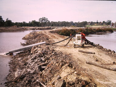 Kew Historical Society Inc
Photograph - Construction of the Eastern Freeway (F19), Ron Setford, March 1972
Ron Setford and his wife Grace Setford lived in Tanner Avenue, East Kew, from c.1946 to c.1995. A keen photographer, he recorded the changing face of Kew over a 20 year period. Apart from 30 photographs of built structures and places in Kew dating from 1960 and 1961, 145 of his 35mm colour slides chronicle the development of the F19 (later renamed Eastern) Freeway through the Yarra Valley in Kew over a five year period from c.1972 to c.1977. This important collection was donated to the Society by his granddaughter in 2025.This collection of 175 35mm slides is of local and statewide significance, owing to its subject matter, particularly the major development of road transport infrastructure during the 1970s with the construction of the Eastern Freeway. The photographer also took care to annotate and date most of his slides which enable the researcher to pinpoint temporal and spatial locations.Photograph of works involved in construction of the F19 (now Eastern) Freeway involving rerouting the River Yarra in Kew."Eastern Freeway / pumping out old river bed"ron setford, eastern freeway, f19 freeway -
 The Beechworth Burke Museum Research Collection
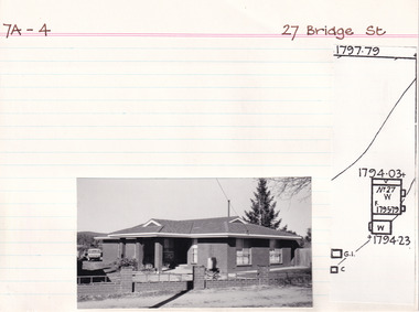
Card (Series) - Index Card, George Tibbits, 27 Bridge Street, Beechworth, 1976
George Tibbits, University of Melbourne. Faculty of Architecture, Building and Town & Regional PlanningIndex system that support the research for Beechworth : historical reconstruction / [by] George Tibbits ... [et al]Arranged by street names of BeechworthEach index card includes: street name and number of property, image of property, allotment and section number, property owners and dates of ownership, description of the property according to rate records, property floor plan with dimensions.beechworth, george tibbitsbeechworth, george tibbits -
 Eltham District Historical Society Inc
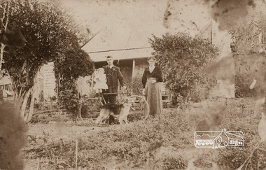
Photograph, Mrs Henry Hill (nee Georgina Reynolds of Research) and others outside the old Hill residence in Bridge Street, Eltham
Early settlers of Eltham Black and white photograph postcardMrs Henry Hill (nee Georgina Reynolds of Research), mother of John Ernest Hill. Identity of others not known to Mrs A.E. Hill , who states 'photo was taken outside the old Hill residence, Bridge St, (south side between Susan and Bolton Streets). Demolished many years ago - 26.7.65 Also stamped - Shire of Elthamhouses, mrs henry hill, bridge street, georgina hill (nee reynolds), hill family, hill family home, john ernest hill -
 Clunes Museum
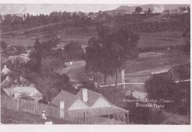
Photograph, BAWDEN PHOTOGRAPHER
PHOTO COPY OF SUSPENSION BRIDGE IN CREEK PARADE CLUNES, TAKEN FROM COUNDON STREET, CLUNES.SUSPENSION BRIDGE CLUNES. BAWDEN PHOTOSlocal history, photography, photographs, bridges and buildings -
 Peterborough History Group
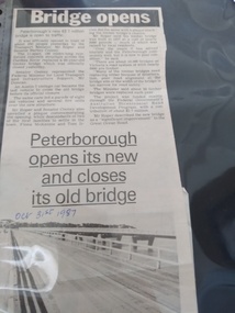
Article - Bridge Opens in Style
Article about the opening of the New Bridge and closing of the Old Bridge.Decribes the ceremonies and plaque dedication of the opening of the new bridge and closing of the old bridgeTwo column article about the opening of the new bridge and closing of the old bridgeHandwritten date.peterborough, peterborough old bridge, peterborough new bridge, curdies river bridge -
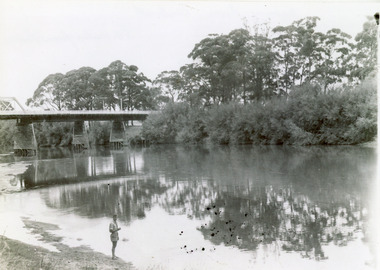
 Lakes Entrance Historical Society
Photograph - Bridges, Murray Views Gympie, 1980
Photo printed on Jumbo card by Murray Views, Gympie QLDColour photograph showing swing bridge on Latrobe River, shows north facing side of bridge, willows on opposite bank on site of Latrobe River wharf, river running very high, two red gum trees in water on left. Longford Victoriabridges, waterways -
 Myrtleford and District Historical Society
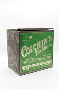
c. 1930s
Metal box with a hinged lid, front panel decorated with silver lettering and green background.Tea No 290. Colchin's Tea Stores PHONE J2565 Direct Importer of Finest Teas, Coffee & Cocoas Always over the Commonwealth Standard of extract ~Blends to suit individual Tastes! 110 BRIDGE ROAD. RICHMOND.. CITY END Your recommendation favoured MELBOURNE -
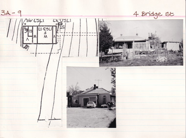 The Beechworth Burke Museum Research Collection
Card (Series) - Index Card, George Tibbits, 4 Bridge Street, Beechworth, 1976
George Tibbits, University of Melbourne. Faculty of Architecture, Building and Town & Regional PlanningIndex system that support the research for Beechworth : historical reconstruction / [by] George Tibbits ... [et al]Arranged by street names of BeechworthEach index card includes: street name and number of property, image of property, allotment and section number, property owners and dates of ownership, description of the property according to rate records, property floor plan with dimensions.beechworth, george tibbitsbeechworth, george tibbits -
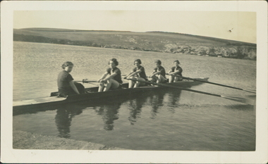 City of Warrnambool Rowing Club
Black and white photograph, 1936
There was a (Warrnambool) Ladies Rowing Club from about 1913. They were autonomous with their own shed, committee and coaches.The photograph is of a ladies crew in a sweep four. They are beside the bank of the Hopkins River, Warrnambool.The back of the photograph has "Before a training spin on the Hopkins River 1936".rowing, warrnambool, hopkins river, ladies rowing, warrnambool rowing club, warrnambool ladies rowing club, city of warrnambool rowing club, city of warrnambool rowing club -
 Clunes Museum
Photograph, 1939
THIS PHOTOGRAPH WAS TAKEN DURING EASTER CENTENARY CELEBRATIONS 1939ORIGINAL PHOTOGRAPH OF BUTTER FACTORY & BRIDGE OVER CREEK.BRIDGE OVER CREEK, PHOTOGRAPH TAKEN FACING TOWARDS THE PARK.local history, photography, photographs, bridges -
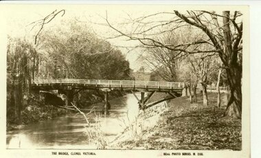 Clunes Museum
Photograph
SEPIA COPY PHOTOGRAPH OF JUBILEE OR QUEEN'S BRIDGE, CLUNES.THE BRIDGE, CLUNES, VICTORIA. REAL PHOTO SERIES M 2155local history, photography, photographs, bridges -
Federation University Historical Collection
Map, Otways Walks and Waterfalls Map, 2013, 06/2013
Tourist map of the Otways showing the townships of Colac, Lorne, Apollo Bay, Beech Forest, Forrest, Barwon Downs, Deans March, Winchelsea, Gellibrand, Lavers Hill, POrt Campbel, Princetown, Johanna, Timboon, Cobden, Camperdown, Swan Marsh, Simpson, Birregurra, Beeac, Marengo, Wye River, Kennett River, Skenes Creek, Peterboroughcolac, lorne, apollo bay, beech forest, forrest, barwon downs, deans march, winchelsea, gellibrand, lavers hill, port campbel, princetown, johanna, timboon, cobden, camperdown, swan marsh, simpson, birregurra, beeac, marengo, wye river, kennett river, skenes creek, peterborough< marriners falls, beauchamp falls, hopetoun falls, triplet falls, little aire falls, stevensons falls -
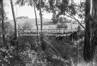 Eltham District Historical Society Inc
Negative - Photograph, Russell Yeoman, Cottles Bridge over Diamond Creek, Cottles Bridge-Strathewan Road, Cottles Bridge, c.1970
Roll of 35mm black and white negative film, 4 of 7 strips and corresponding B&W printIlford HP4bridge, cottles bridge, cottles bridge-strathewen road, diamond creek (creek) -
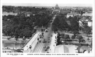 Melbourne Tram Museum
Postcard, Rose Stereograph Co, "Looking across Princes Bridge to St Kilda Road, Melbourne", late 1930s
Rose Series postcard No. P 4287, titled "Looking across Princes Bridge to St Kilda Road, Melbourne" taken from the Flinders St station clocktower. The photo looks down to the Shrine of Remembrance. Has two W2 class trams in St Kilda Road, a W2 in City Road, and a Maximum Traction type C or E class tramcar at the Batman Ave terminus. Includes some horse-drawn vehicles and possibly an overhead tower truck at the intersection with City Road. Yields information about St Kilda Road mid to late 1930sPostcard - printed real photograph with Rose Stereograph Co. name on the rear.trams, tramways, w2 class, swanston st, batman ave, st kilda road, shrine of remembrance -
 Lakes Entrance Historical Society
Photograph - Bridges, 1947
Date made February 1947Black and white photograph showing part of the road bridge over there Snowy River, river level low, man in shorts standing at edge of river. Orbost, Victoria.bridges, waterways, recreation -
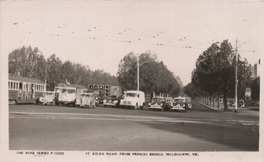 Melbourne Tram Museum
Postcard, Rose Stereograph Co, "St Kilda Road, from Princes Bridge Melbourne Vic", c1950
Postcard - Black and White - Rose Series P13352, titled "St Kilda Road, from Princes Bridge Melbourne Vic", featuring a traffic in St Kilda Road, all stopped (by a traffic policeman) at the intersection with City Road - has 7 motor vehicles all neatly stopped in a line and two tramcars (W2). Includes three black and white taxis - tow of the FJ Holden type. The City Road tram tracks are in the foreground. On the rear - has a divided back, and "A Real Photograph" " & Produced in Australia".On the rear has the stamp of Graeme S Breydon - see image i2.trams, tramways, melbourne, princes bridge, st kilda rd, city rd -
 Wodonga & District Historical Society Inc
Photograph - Murray River "Railway" Hotel, Wodonga
Located in High Street, Wodonga, this hotel underwent many modifications and name changes. It was built c1859 by James Bambrick close to the intended rail terminal in Huon Street. The site of the rail terminal actually changed but the name remained. James Bambrick served three terms as Wodonga Council president and was it was commonly referred to as “Bambrick’s Hotel”. It included 30 rooms as well as dining facilities. James Bambrick ran the hotel until 1902 when it was sold to J. Donnelly for £3,000. In 1912, whilst operated by T. J. Weller, the residential section of the hotel was almost completely destroyed by fire but only the ceiling of the bar was damaged and it continued to operate. Over the ensuing years the licensee changed hands frequently. By 1952, John Perry, owner of the “Stump” Junction Hotel also had the freehold of the Railway Hotel At some stage in the mid 1980’s the hotel was renamed as the “Murray River Hotel”, but still displayed the sign of the Railway Hotel. In 2009, it was closed for a short time whilst renovations took place to convert it into O’Maille’s Irish Hotel. It was demolished in 2020. These images document changes to an important local building first established c1868. It was an important meeting place and also the location of the earliest Council meetings in Wodonga.A set of photos both black and white and colour depicting changes to the Railway Hotel, Wodonga over timeA variety of names and advertising signsjames bambrick wodonga, bambrick's hotel, railway hotel wodonga, murray river hotel wodonga, o'maille's hotel,