Showing 11033 items matching " land"
-
 Glenelg Shire Council Cultural Collection
Photograph - Photograph - Lee Breakwater, Portland, n.d
Port of Portland Authority Archivesport of portland archives, lee breakwater, construction, workers, trade -
 Bendigo Historical Society Inc.
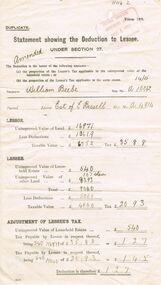
Document - GLENYS MCKITTERICK COLLECTION: WILLIAM BEEBE DOCUMENTS, 14/15
Buff coloured flimsy document. Statement showing the deduction to Lessee under Section 27. Issues to taxpayer William Beebe, estate of E. Bissell. No. A 4814. Unimproved value of land 16,971 pounds.person, bendigo, william beebe -
 Port Melbourne Historical & Preservation Society
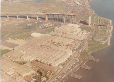
Photograph - Aerial view of West Gate Bridge under construction, 1960 - 1979
Colour aerial (faded) photograph of West Gate Bridge under construction with two land spans incomplete. "Rotten Row" (disused old piers) in the foreground. Aircraft factory and other industry in foreground."Master Copy . Not to be removed from Marketing department " lightly stamped on photo. and on reartransport, engineering, engineering - bridges, fishermans bend, industry, west gate bridge, rotten row, williamstown, yarra river -
 National Vietnam Veterans Museum (NVVM)
Print - Print, Framed, We're outta here
Timber framed, red bordered, signed print 110/250, Mike Eggleston 2783957. Depicting 13 soldiers crouching on the ground, in the foreground and 7 Hueys coming in to land. Other troops in the background.We're outta here, Mike Eggleston 2783957, 110/250. On the reverse side are the signatures of D&E PL/1 HRU Reunion, 2010huey, print -
Port Melbourne Historical & Preservation Society
Document - Photocopy, relating to Robyn Clinch's research report, History of Some Women of Port
White envelope containing A4 and A3 photocopies of birth certificates and land records supplementary to Robyn Clinch's research report 'History of Some Women of Port Melbourne' (nb these do not appear in the report)women -
 Bendigo Historical Society Inc.
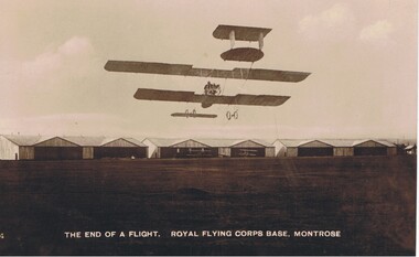
Postcard - BASIL WATSON COLLECTION: ROYAL FLYING CORPS BASE, MONTROSE, UK
Black and white postcard: On bottom of postcard : ' The End of a flight. Royal Flying Corps Base, Montrose. Image shows bi-plane about to land on aerodrome, hangars in background on edge of airfield at Montrose.Davidson's Real Photographic Seriesmilitary, aviation, royal flying corps -
Whitehorse Historical Society Inc.
Letter - Correspondence, Samuel and Ivy Davidson, 10/07/1992 12:00:00 AM
Letter from Jean Mannix accompanying photo and land sale brochure with details of her family - parents, Samuel and Ivy Davidson and brother Donald from the Blackburn area. Ref: NP977; ND2809Letter from Jean Mannix accompanying photo and land sale brochure with details of her family - parents, Samuel and Ivy Davidson and brother Donald from the Blackburn area. Ref: NP977; ND2809Letter from Jean Mannix accompanying photo and land sale brochure with details of her family - parents, Samuel and Ivy Davidson and brother Donald from the Blackburn area. Ref: NP977; ND2809blackburn, davidson, samuel graham, davidson, ivy may, brennan, ivy may, davidson, jean iona, mannix, jean iona, davidson, donald kevin, mascot estate, blackburn -
Whitehorse Historical Society Inc.
Document, German Evangelical Lutheran Church, 1853?
Letter from parishioners of the German Evangelical Lutheran Church, indicating the name of the CHurch's minister, and their intention to erect a church in East melbourne on a grant of land near St Peter's.Letter from parishioners of the German Evangelical Lutheran Church, indicating the name of the CHurch's minister, and their intention to erect a church in East melbourne on a grant of land near St Peter's. Signed by Pauline Schwerkolt.Letter from parishioners of the German Evangelical Lutheran Church, indicating the name of the CHurch's minister, and their intention to erect a church in East melbourne on a grant of land near St Peter's.german evangelical lutheran church, schwerkolt, pauline -
Whitehorse Historical Society Inc.
Pamphlet, Smithfield Walk, Vermont, n.d
Advertisement for housing development: 'Homestead Rise' at Smithfield Walk, Vermont. Land originally owned by L.L. Smith; purchased in 1924 by David Hastie Harvie. Developer: Residential Developments Australia Pty Ltd.auctions, smithfield walk, vermont, harvie, david hastie, residential developments australia pty ltd, homestead rise estate, vermont -
 Whitehorse Historical Society Inc.
Letter - Correspondence, Roads, 10/10/1867
Letter from S. Padgham to Road Board Engineer dated 10 October 1867 re representations by Mr Cook about location of road relating to Mr Cumming's land and Marshall's Gully.marshall's gully, roads and streets, cook, william, cummings, (mr), padgham, silas -
 Whitehorse Historical Society Inc.
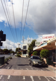
Photograph, Mitcham North Shopping Centre, 2006
Coloured Photo of Mitcham North Shopping Centre (opposite Park Road) looking south. Communications towers situated on roof of a security service building. Land surveyor and chemist on right (west side ).mitcham north shopping centre, shops, shopping centre -
 Bendigo Historical Society Inc.
Document - MARKS COLLECTION: HOBSON AND LANSELL PLANS SHOWING LAND IN DISPUTE
Plan, hand drawn, showing Hobson and Lansell plan 'shewing ground in dispute' On plan East Johnson Lease Ground, Hobson and Lansell land in between, West of England company on bottom of plan.bendigo, mining, hobson and lansell -
Kew Historical Society Inc
Archive (Series) - Subject File, Eastern Freeway (Kew), 1979
Organisation generatedReference, Research, InformationSecondary Values (KHS Imposed Order)Subject file containing sundry newspaper files about protests against the freeway’s construction, land acquisition, speeding, noise etc. There is also a CRB brochure of ‘Your Eastern Freeway Driver’s Guide’kew (vic) - history, kew east (vic) - community groups, kew (vic) - roadskew (vic) - history, kew east (vic) - community groups, kew (vic) - roads -
Surrey Hills Historical Society Collection
Document, Copy of title, 391 Mont Albert Road, Surrey Hills
Victoria Melba Turner (known as Melba) and Elizabeth Maitland Anderson trained together at the Melbourne Hospital, completing their training just months apart; Melba in October 1914 and Elizabeth in May 1915. Both were registered on 31.3.1925 and listed at 391 Mont Albert Road, the site of Mosgiel Private Hospital. Note that the road was subsequently re-numbered and became 293 Mont Albert Road. 391 Mont Albert Road had previously been the home of the Sherar family and had originally been built for Charles J Currie, a solicitor. Three pages relating to the title of 391 Mont Albert Road. Historical search statement from Land Use Victoria is dated 15/09/2020. The reference is Vol 5414, Fol 1082747. 391 mont albert road, victoria melba turner, amy lillian hughes, muriel harper gilchrist, mosgiel hospital, 293 mont albert road, sherar family, charles j currie, quamby, elizabeth maitland anderson -
 Surrey Hills Historical Society Collection
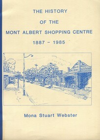
Book, Box Hill Historical Society et al, The history of the Mont Albert Shopping Centre, 1986
Born in 1900, Mona was the daughter of Florence Jane McDowall Stuart (1867-1936) and George Hudson Grant (1864-1910) who married in 1899. He was a surveyor and they lived in Albany Crescent, Surrey Hills. Her full name was Jessie Mona Stuart Grant and she had a sister Mollie. In 1924 she married Clarence William Willoughby Webster (1895-1980) - SERN 33286. Clarence was born in Thorpedale where his father was a teacher. He was living in View Street Mont Albert and was a law student when he enlisted on 3 October 1916. After discharge on 10 May 1919, Clarence returned to his studies. He joined a legal firm in the city which became Pearce & Webster (later Pearce Webster Dugdale). Mona and Clarence lived in Surrey Hills and Mont Albert in a number of homes for the remainder of their lives.A history of the Mont Albert Shopping Centre in Hamilton Street, Mont Albert, including the early land use, and a chronology of shop owners. Index, photos., 39p. Compiled by local resident, Mona Webster.On front cover: top RH corner "Kay Kirkwood/98995158"phoenix park estate, mont albert, hamilton street, (mr) - mckerdy, (mr) - andrew, (mr) - dunn, (lady) emma hamilton, railways, churchill street, surrey hills golf club, (mrs) mona webster -
 City of Kingston
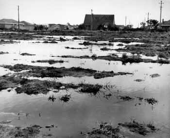
Photograph - Black and white, c. 1958
Unsealed roads and drainage problems created difficulties for those living in Beaumaris during the 1950sBlack and white image depicting the Balcombe Road and Haywood Street, Beaumaris. Unsealed roads and drainage problems have created boggy slushy land. There are houses in the background, indicating people live in the area.Handwritten in red ink on reverse: 90% Handwritten in blue ink on reverse: 2193beaumaris, roads, drainage, water logged, housing -
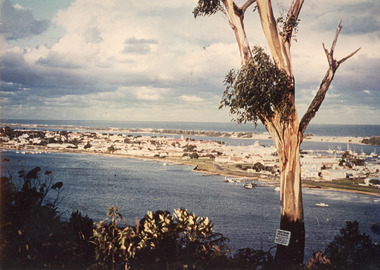 Lakes Entrance Historical Society
Photograph - Township, 1980
Also two different views of Lakes Entrance from KalimnaColour photograph showing the township situated on the land between the two stretches of water, the North Arm and the Cunninghame Arm. In the background can be seen the sand hummocks and the Southern Ocean. Lakes Entrance Victoria township, waterways -
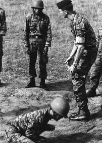 National Vietnam Veterans Museum (NVVM)
Photograph, Gibbons, Denis, Bearcat, South Vietnam
Denis Gibbons (1937 – 2011) Trained with the Australian Army, before travelling to Vietnam in January 1966, Denis stayed with the 1st Australian Task Force in Nui Dat working as a photographer. For almost five years Gibbons toured with nine Australian infantry battalions, posting compelling war images from within many combat zones before being flown out in late November 1970 after sustaining injuries. The images held within the National Vietnam Veterans Museum make up the Gibbons Collection. A black and white photograph - Bearcat South Vietnam, 1970, a member of Australian Army Ttraining Team Vietnam (AATTV) instructs Vietnamese Ranger recruits in the correct way to land during parachute trainingphotograph, bearcat, aattv, arvn soldier, gibbons collection catalogue, australian army training team vietnam (aattv), vietnamese ranger, parachute training, denis gibbons -
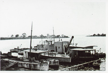 Lakes Entrance Historical Society
Photograph - Paynesville Slipway, 1910 c
Photocopy of photograph has names of all the boats, W H Edgar, suction dredge called Paynesville, grab dredge called Priest Man, stores barge called Lady Harriet, a boat used to keep rivers free of snags called Snagger, sand hopper barge from W H Edgar in process of being dismantled. Information provided by Reg Schulz.Black and white photograph showing five boats / barges at slipway, one with crane. Little row boat in foreground at jetty. Point of land in background, Raymond Island, sparse vegetation. Paynesville Victoriaships and shipping, wharfs -
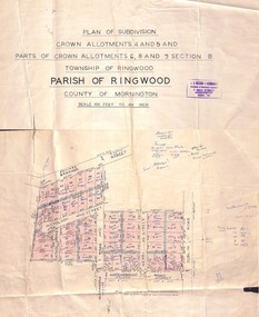 Ringwood and District Historical Society
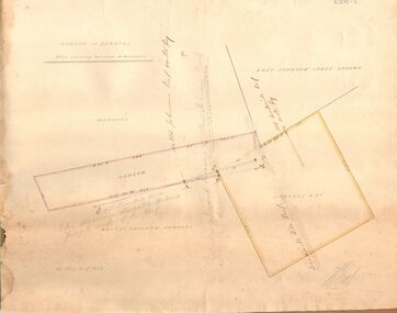
Map - Plan of Subdivision, Crown Allotments 4 and 5, and Parts of Crown Allotments 6, 8 and 9 Section B, Township and Parish of Ringwood, County of Mornington - Salter's Estate East Ringwood Victoria - 1956
Land Title map of 51 allotments with property dimensions and handwritten real estate sales notations. Copy of map on cardboard backing - extracted from auction advertisement for Saturday, 10th November (1956).Subdivision includes Railway Avenue, Nicholson Street, Althol Grove (later Morcom Avenue), Illoura Avenue, Tweed Street, Merry Street, and Dublin Road, Ringwood East, Victoria. -
 Ringwood and District Historical Society
Map, Plan of Subdivision - State School Estate, Ringwood East, Victoria - (Undated, circa 1920s)
Map of land for sale attached to green cardboard backing with handwritten notations showing numbered allotments on Dublin Road, Holland Road, King Street, Charles Street and Purser Avenue, Ringwood East.Locality plan includes reference to proposed Ringwood East railway station which opened in 1925. -
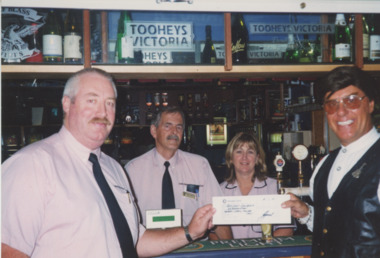 Lakes Entrance Historical Society
Photograph - Lakes Entrance Bowls Club, Lakes Post Newspaper, 2001
Colour photograph Bowls Club Manager Geoff Rhodes presenting cheque to John Couzens, Land Mine Amputees Fundraiser. Bill Aitkens and Jenny Dowie behind the bar. Lakes Entrance Victoriabowls club, donation, fundraising -
 Bayside Gallery - Bayside City Council Art & Heritage Collection
Map, H.B. Foot, Plan of the Brighton Estate containing 5120 acres, first special survey at Port Phillip, c. 1842
This plan records the Brighton Estate, also known as Dendy's Special Survey. In 1840 Henry Dendy, a farmer in Surrey, England acquired a "Special Survey" from the Commissioners for Land and Emigration which gave him the right to choose land in Port Phillip for the low price of £1 per acre for 5120 acres. Dendy appointed Jonathan Binns Were, as his agent, who later became a partner. Together, Dendy and Were decided on an area 5 miles south from Melbourne, bounded by North Road, East Boundary Road, South Road and to the west by Port Phillip Bay. Their Brighton Estate was first surveyed by T. S. Townsend in May 1841 and was re-surveyed by Robert Hoddle. Dendy and Were were making plans to sell the land and advertised a 30-guinea prize for the best subdivision which was to be divided into a village, marine residences, suburban and cultivation allotments, with the remainder being divided into country sections. The competition was won by H.B. Foot, who planned the village around a reserve and crescents and a 'green belt' forming the town boundary. brighton estate, dendy's special survey, special survey, henry dendy, jonathan binns were, w.b. were, survey, plan, map, brighton, george ward cole, baker's lithographer, hibernian, subdivision, town planning, cartographic material, h.b. foot -
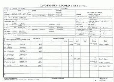 Bendigo Historical Society Inc.
Photograph - The Wilkin Family of Sedgwick - Isaac and Letitia Barcley, 1800s-1900s
The Phil Wilkin Collection contains a series of 11 Items. The related items can be found by clicking on the reference link below. The following history of the Young family and their descendants who lived at the Springs is provided by Phil Wilkin. His Great Grandparents were Frances Young and August Wirth. Phil has also provided notes on the Wilkin Family and some history of the gold mining in Sedgwick. Frances Young's parents Joseph and Margaret Young owned the property called "The Old Place, Preston Vale or Wellington Flat" at Sedgwick near the Springs. Joseph Young owned and Managed the Standard Brewery which was located at Campbells Creek during the late 1800’s early 1900’s. Joseph and Margaret are buried in the Harcourt cemetery. In 1880 August Wirth lived at Mosquito Creek (Lake Eppalock, Victoria) when he married Frances Young. In 1902 they moved to part of Joseph Young's property. They milked cows and sold cattle for a living. One of their children Charles Wirth (Phil Wilkin's Grandfather) bought the land in 1935 after his parents had died. Charles Wirth was a councillor and also was president of the Shire of Strathfieldsaye. The "Old Place" was part of the property owned by members of the family. The old house at the Springs was burnt out by bushfire in January 1944 and much of the stonework was later vandalized by campers. The original Coliban Water Works were designed in 1863 by the Irish engineer Joseph Brady. The system included 70 kilometres of open water channels, aqueducts, syphons and tunnels to carry water (by gravity) from the Coliban River at Malmsbury, north to Castlemaine and Bendigo. Sedgwick is a locality in Central Victoria, Australia. It is located in the City of Greater Bendigo. Facilities include a public hall that opened in 1958 and CFA Rural fire station. It was named Upper Emu Creek until 1901 when it was renamed as Sedgwick after British geologist Adam Sedgwick.Seven historical documents of Isacc and Letitia Barcley who were associated with the Wilkin Family and also with the Springs near Sedgwick. There are 182 photos in this series and can be found at 8683.1 to 8683.11. The series also includes photos of the surrounding farming land and the remains of an old house. There are also some notes on the pioneers of the district.history, bendigo, coliban water, joseph brady, irrigation, the springs, sedgwick, phil wilkin collection, joeseph and margaret young, letitia and isacc barclay -
 Bendigo Historical Society Inc.
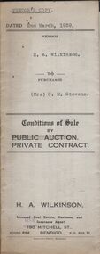
Document - H.A. & S.R. WILKINSON COOLLECTION COLLECTION: CONDITIONS OF SALE
Conditions of sale by private contract dated 2nd March, 1939 between H.A. Wilkinson (seller) and Mrs. C.M. Stevens (buyer) for land situate No. 1 Carolin Street, Bendigo being part of Crown allotment 217 section H being land described in certificate of volume 6129 folio 1225728, together with 4-roomed weatherboard dwelling and all sundry. Also gas stove and all wire window screens. Price 650 pounds. Vendor's copy.organization, business, h.a. & s.r wilkinson real estate -
 Bendigo Historical Society Inc.
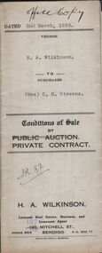
Document - H.A. & S.R. WILKINSON COLLECTION: CONTRACT OF SALE
Conditions of sale by private contract dated 2nd March, 1939 between H.A. Wilkinson (seller) and Mrs. C.M. Stevens (buyer) for land situate No. 1 Carolin Street, Bendigo being part of Crown allotment 217 section H being land described in certificate of volume 6129 folio 1225728, together with 4-roomed weatherboard dwelling and all sundry. Also gas stove and all wire window screens. Price 650 pounds. Office copy.organization, business, h.a. & s.r wilkinson real estate -
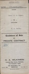 Bendigo Historical Society Inc.
Document - H.A. & S.R. WILKINSON COLLECTION: CONTRACT OF SALE
Conditions of sale by private contract dated 13th March, 1941 between Mrs. H.C. Dixon (seller) and W.C. Smith (buyer) for land situate No. 467 Backhaus Street, corner Sheridan Street, Long Gully being land described in right to occupy residence area No. 7368, together with 5-roomed weatherboard and brick dwelling and all sundry. Also ''Liverpool'' gas stove, wire doors and window screens, electric light globes and shades, but no fancy shades. Price 415 pounds.organization, business, h.a. & s.r wilkinson real estate -
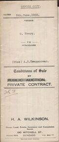 Bendigo Historical Society Inc.
Document - H.A. & S.R. WILKINSON COLLECTION: CONTRACT OF SALE
Conditions of sale by private contract issued by H.A. Wilkinson house, land, estate, insurance and commission agent, 190 Mitchell street, Bendigo and dated 5th June 1935between G. Every (seller) and Miss A.E. Treganowan (buyer) for land situate George Street, Bendigo being part of Crown allotment 77 section H described in certificate of title volume 5378 folio 1075507, together with 4-roomed bungalow and all sundry. Price 534 pounds.organization, business, h.a. & s.r wilkinson real estate -
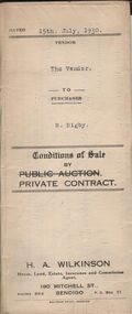 Bendigo Historical Society Inc.
Document - H.A. & S.R. WILKINSON COLLECTION: CONDITION OF SALE
Conditions of sale by private contract dated 15th July, 1930 between H.A. Wilkinson (seller) and R. Rigby (buyer) for land situate Wallan Street, California Gully, being Crown allotment 148 section M described in certificate of title volume 3651 folio 730163, together with 5-roomed weatherboard dwelling and all sundry. Also all vendor's interest in and to the adjoining block of land on the lower side of the above mentioned property. Price 100 pounds.organization, business, h.a. & s.r wilkinson real estate -
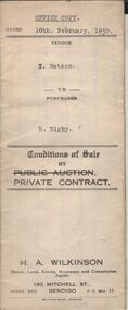 Bendigo Historical Society Inc.
Document - H.A. & S.R. WILKINSON COLLECTION: CONTRACT OF SALE
Conditions of sale by private contract dated 15th July, 1930 between H.A. Wilkinson (seller) and R. Rigby (buyer) for land situate Wallan Street, California Gully, being Crown allotment 148 section M described in certificate of title volume 3651 folio 730163, together with 5-roomed weatherboard dwelling and all sundry. Also all vendor's interest in and to the adjoining block of land on the lower side of the above mentioned property. Price 100 pounds.organization, business, h.a. & s.r wilkinson real estate