Showing 8323 items
matching the bridge
-
 Lakes Entrance Historical Society
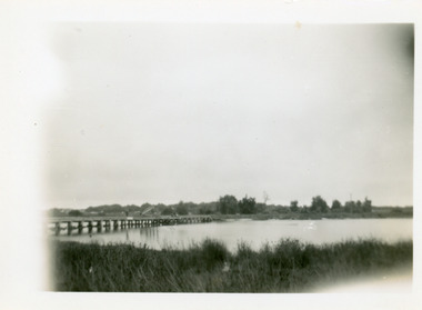
Photograph - Bullock Island, 1930c
Black and white photograph of Bullock Island, showing sparse vegetation on island, low foot bridge to island, reedy vegetation in foreground. Lakes Entrance Victoria topography, islands, bridges -
 Lakes Entrance Historical Society
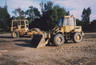
Photograph - Skate Park, Lakes Entrance Tidy Towns Committee, 1999
also second colour photograph ground cleared and levelled in preparation for skate park 1999Colour photograph bulldozers levelling the proposed site for the skate park, previously the southern roadway approach to the previous North Arm bridge. Lakes Entrance Victoriasporting facilities, construction -
 Lakes Entrance Historical Society
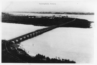
Photograph - Norm Arm bridge, Lakes Entrance Victoria c1900, 1900c
Black and white photograph of the bridge over the Norm Arm, showing the town of Cunninghame, including the Club Hotel, the sand hummocks and Cunninghame. Lakes Entrance VictoriaCunninghame Victoriabridges, township, coast -
 Lakes Entrance Historical Society
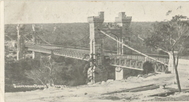
Postcard - Mary Lydia Laughton/Correspondence, 1905
Posted 31.7.1905 from N. S. W. to Miss Laughton Kalimna Lakes Entrance Victoria Message says Please keep this card for my collection am getting a few more Yours GBlack and white postcard of suspension bridge North Sydney showing bushland in distance Sydney Australia.Plus second photo showing details of message on rear side.city, correspondence, hobbies, hotels -
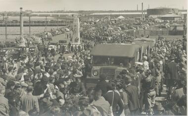 Port Melbourne Historical & Preservation Society
Photograph - Crowds welcoming returning wounded troops, Port Melbourne, Roy Liebig, 1945
The donor's (Karen Bowden) grandfather - Roy Liebig (1897-1968) - took these photos in the 1940s. Karen, as administrtor of his estate, has extracted various photos and sent them to appropriate historical societies.A series of photographs taken by Roy Liebig in the 1940s Hard copy and digital. Crowds at Port Melbourne, ambulances carrying wounded. Centenary bridge pylon in backgroundmaritime, piers and wharves, war - world war ii, piers and wharves - station pier, roy liebig, karen bowden, yarra river, centenary bridge -
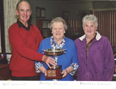 Lakes Entrance Historical Society
Photograph, Lakes Post Newspaper, Bridge Club Lakes Entrance Victoria, 1/08/2012 12:00:00 AM
with Club members Bill and Heather Corwall Lakes Entrance VictoriaColour photograph showing Shirley Hancock holding LE Bridge Club Championship trophy with Club members Bill and Heather Corwall Lakes Entrance Victoria clubs, bridge club -
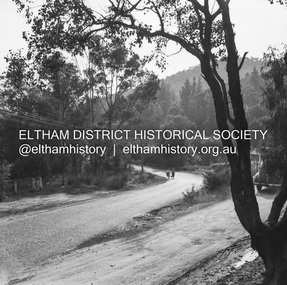
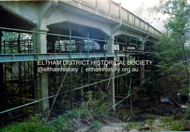 Eltham District Historical Society Inc
Photograph, Ruth H. Pendavingh, Reconstruction of Main Road from Main Road Bridge to Mount Pleasant Road, Eltham, 1984
The original timber bridge over the Diamond Creek was built around 1840. It was destroyed by floodwaters in October 1923. A temporary bridge was rigged up but further damaged in April 1924. A new concrete bridge was built and opened in October 1926. The bridge decking was widened along with Main Road to Dalton Street by the Road Construction Authority in 1984. The upgraded bridge was re-opened October 25, 1984, 78 years after its original opening. (EDHS Chronology of known local events 1835- early 2000)Three colour photograph prints 1984, bridge construction, diamond creek (creek), eltham south, main road, main road bridge, road construction -
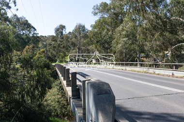 Eltham District Historical Society Inc
Photograph, Peter Pidgeon, Manna Gum, Main Road Bridge, Eltham South, 8 Sep. 2021
This significant tree located near the Main Road Bridge over the Diamond Creek at Eltham dates back to approximately 1870-1880. Though dead now, its trunk has been left as a wildlife habitat. The original timber bridge over the Diamond Creek was built around 1840. It was destroyed by floodwaters in October 1923. A temporary bridge was rigged up but further damaged in April 1924. A new concrete bridge was built and opened in October 1926. The bridge decking was widened along with Main Road to Dalton Street by the Road Construction Authority in 1984., The uygraded bridge was opened in October 1984, 78 years after its original opening.These trees are not only significant for the natural environment but also present a navigational beacon back in time as the environmental landscape is developed around them.Born Digitaleltham south, main road bridge, manna gum, significant tree -
 Warrnambool and District Historical Society Inc.
Financial record - Ledger, Warrnambool Shire Council 1899-1918, Circa 1900
Provides a collection of letters to the President and Councillors of the Shire of Warrnambool from J. M. Crawley. The period covered is 1900 to 1918. It covers such topics as repairs to bridges, purchasing of equipment, complaints, applications for roads. Names of places and structures include Dennington Bridge, Cassidy’s Bridge, Warrumyea Bridge, Yangery, Purnim. Loose within the book is a letter from a W,M(H?) Clarke of Garvoc. The letters contained in this ledger provide information on a large range of works which were carried out in the Shire in the early 1900’sDark olive green fabric cover with tan spine and cornersMinute Book in gold lettering on red background on spine.warrnambool shire council 1899-1918, crawley j w crawley, warrnambool shire offices, warrnambool -
 Eltham District Historical Society Inc
Photograph, Fay Bridge, Centenary celebration, Monash Bridge, Hurstbridge, 7 November 2017
The area of Hurstbridge was originally known as Hurst’s-bridge after the timber bridge built over the Diamond Creek near Hurst’s station in late 1881/early 1882. It was replaced by a new concrete bridge designed by Sir John Monash over the Diamond Creek near Hurst's home of 'Mia Mia' at Hurstbridge. The official opening of the new Monash bridge at Hurstbridge was held 3 November 1917.fay bridge collection, 2017-11-07, hurstbridge, hurstbridge heritage trail, monash bridge, ruins -
 Eltham District Historical Society Inc
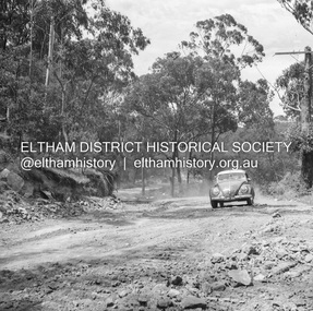
Album - Photograph, J.A. McDonald, Eltham-Greensborough Road, July 1956
Diamond Creek Bridge (Bridge Street Bridge) General view looking to Main Road View looking east up Bridge Street to Main Road prior to widening. The Eltham Obelisk is located at the top of the hill on the left but was relocated to the Eltham RSL front garden as a reesult of road widening works and improvements to the intersection. On the immediate right is the present-day Eltham Rugby Union ovalRecord of various Shire of Eltham infrastructure works undertaken during the period of 1952-1962 involving bridge and road reconstruction projects, sometimes with Eltham Shire Council Project Reference numbers quoted. It was during this period that a number of significant improvements were made to roads and new bridges constructed within the shire that remain in place as of present day (2022). In many situations, the photos provide a tangible visible record of infrastructure that existed throughout the early days of the Shire. The album was put together by or under the direction of the Shire Engineer, J.A. McDonald.infrastructure, road construction, shire of eltham, bridge construction, bridge street bridge, eltham, eltham-greensborough road, 1956-07 -
 Greensborough Historical Society
Photograph - Digital Image, Anne Paul, Opening of restored Old Lower Plenty Bridge 2001 - area adjacent, 14/03/2001
The opening of the restored Old Lower Plenty Bridge, opened on 14/03/2001 by the Minister for Environment and Conservation Sherryl Garbutt MLA and Mayor of Banyule Cr Dale Peters. The project was jointly funded by Banyule Council and Parks Victoria. The restored bridge is the oldest remaining bridge in Nillumbik and forms part of the Plenty River Trail. this photograph shows the area adjacent to the bridge on the day of the opening.Digital copy of colour photographlower plenty, lower plenty bridge, sherryl garbutt, dale peters, banyule council, parks victoria -
 Eltham District Historical Society Inc
Negative - Photograph, J.A. McDonald, Heidelberg-Kinglake Road, 11 May 1961
Silvan Road Bridge Looking northwards before reconstruction View centreline to left of old bridge site 11 May 1961Record of various Shire of Eltham infrastructure works undertaken during the period of 1952-1962 involving bridge and road reconstruction projects, sometimes with Eltham Shire Council Project Reference numbers quoted. It was during this period that a number of significant improvements were made to roads and new bridges constructed within the shire that remain in place as of present day (2022). In many situations, the photos provide a tangible visible record of infrastructure that existed throughout the early days of the Shire. The album was put together by or under the direction of the Shire Engineer, J.A. McDonald.1961-05-11, heidelberg-kinglake road, infrastructure, bridge construction, shire of eltham, reconstruction works, road construction, silvan road bridge -
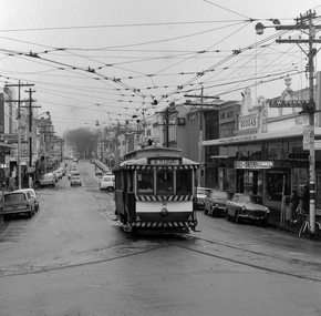
 Melbourne Tram Museum
Photograph - X 217 Hawthorn Depot, c1925
Shows X class tram No. 217 at Hawthorn Depot with a bow collector. Tram has the destination of "Bridge Rd" (Bridge Road). Yields information about X 217 when it was fitted with a bow collector and Hawthorn Depot.Black and white photograph notes on rearIn ink by Keith Kings: - X217 Hawthorn depot about 1925, courtesy of Mr Stephenson Preston Workshops", has Rev L Marshall Wood stamp and K S Kings stamp - with number S-A 111.tramways, tramcars, tram 217, hawthorn depot, bow collector, x class, mmtb -
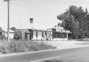 Ringwood and District Historical Society
Photograph, Burnt Bridge Store, Feb 1960 (2 views)
Written on back of one photograph, "Burnt Bridge Store. Demolished 1969. New World super market and shops built on or about site. Feb. 1960". On another copy "Ex BB Hotel, Demolished 3-4.69". On another copy: "Old Burnt Bridge Hotel (Sam Cutts)" -
 Greensborough Historical Society
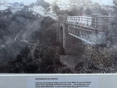
Photograph - Photograph (Framed), Greensborough bridge, 1870s
Greensborough bridge caption reads: "This fine old bluestone bridge was built in the 1860s to carry increasing traffic to the gold fields and farms to the north. The stonemason was James Neave McKenzie. In more recent years this magnificent stone structure had to be replaced by a more modern bridge."From the John Davidson collection.Photograph in black plastic frame with typed caption on matte.john davidson, mckenzie bridge, greensborough, blue stone bridge -
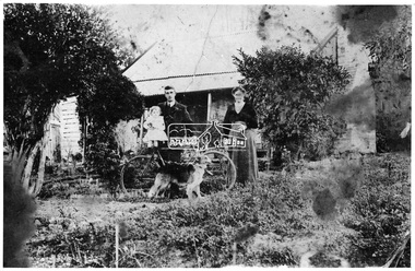 Eltham District Historical Society Inc
Negative - Photograph, Hill family home, Bridge Street, Eltham, c.1892
Mrs. Henry Hill (nee Georgina Reynolds of Research), mother of Arthur Ernest Hill (1891-1961). Taken outside the old Hill family home in Bridge Street, south side between Susan and Bolton Streets. Demolished many years prior to 1965. Georgina Reynolds (1864-1927) married Henry Hill (1862-1948) in 1884. Arthur Ernest Hill was married to Edna Hill. Edna Hill donated the postcard to the Shire of Eltham in 1965, four years after her husband Arthur Ernest Hill's death. At the time she did not know the identity of the others in the photo but it is possible that it is Henery Hill and baby Arthur Ernest Hill.This photo forms part of a collection of photographs gathered by the Shire of Eltham for their centenary project book,"Pioneers and Painters: 100 years of the Shire of Eltham" by Alan Marshall (1971). The collection of over 500 images is held in partnership between Eltham District Historical Society and Yarra Plenty Regional Library (Eltham Library) and is now formally known as the 'The Shire of Eltham Pioneers Photograph Collection.' It is significant in being the first community sourced collection representing the places and people of the Shire's first one hundred years.Digital image 4 x 5 inch B&W Neg Sepia postcard 8.5 x 13.5 cmOn reverse of postcard: Mrs Henry Hill (nee Georgina Reynolds of Research) Mother of Arthur Ernest Hill. Identity of others not known to Mrs A.E. Hill, who states 'photo was taken outside the old Hill residence, Bridge St, (south side between Susan St. & Bolton St.) Demolished many years ago - 26.7.65 Also stamped - Shire of Elthamsepp, shire of eltham pioneers photograph collection, eltham, georgina hill (nee reynolds), hill residence, bridge street, hill family, hill family home, houses, mrs henry hill, arthur ernest hill, henry hill -
 Ballarat Tramway Museum
Photograph - Digital image Set of 2, Peter Bruce, "No.30 Bridge and Main", 1970s
Yields information about Bridge St Ballarat and its associated shopping strip.Digital image, black and white, two images, of No. 30 in Bridge St. 4605.1 - at Stones Corner, enroute to Mt Pleasant with Rodda's, Gill & O'Keffe, C.W. Pennan, ANZ Bank and other shops in the background. Note the signal lamps on the right hand side of the photo above the tram stop sign and how the overhead was arranged at this junction. 4605.2 - at Grenville St end, with Faulls Shoes, Suttons HMV and other shops in the background. Photo taken by Peter Bruce 1970's and 1971, prior to the closure of the Ballarat tramway system. Peter's Title of image: "No.30 Bridge and Main" and "No. 30 Bridge St up end".trams, tramways, bridge st, mt pleasant, tram 30 -
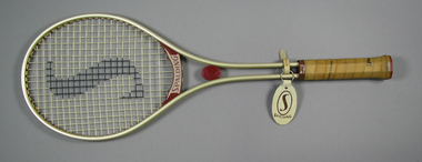 Tennis Australia
Racquet, Circa 1980
A Spalding 'Targa' model metal tennis racquet, with double shaft, red plastic throat bridges; red plastic shaft casing; and handle wrapped in light tan Spalding-branded leather. Red plastic butt cap has adhesive label featuring 'S' logo. Manufacturer's name embossed in white across throat bridge on reverse; on obverse model name is embossed also in white on throat bridge. 'S' logo spraypainted onto net in black. An oval leather Spalding key-ring tag is attached to the shaft pillar. Materials: Metal, Adhesive tape, Plastic, Leather, Adhesive label, Nylon, Painttennis -
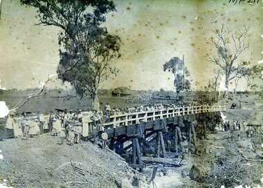 Bendigo Historical Society Inc.
Photograph - AXEDALE BRIDGE
Sepia photograph. Wooden bridge over dry creek ( possibly Campaspe or Axe Creek ?) Dead trees lying in creek. Large group of people, men women and children on bridge. Horse and vehicle at CR. Haystack in centre with stock yards. Inscriptions: On back - in pencil 'Mrs Harris Axedale 21/-' Circular stamp and 1/2 circular stamp 'Royal Historical Society of Victoria, Bendigo Branch'. Pencil note front BR - indecipherable. History: Prev. Acc. No. MP211 Research indicates that this is the bridge over Axe Creek, on the Sugarloaf Road, Axedale. The property in the background belonged to Jonathan and Harriet Harris.place, landscape view -
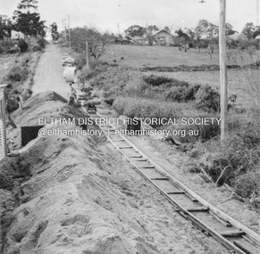
 Eltham District Historical Society Inc
Negative - Photograph, J.A. McDonald, Eltham-Diamond Creek Road, 21 Sep 1959
Bridge construction Eltham-Diamond Creek road over the Diamond Creek (Wattletree Road), Eltham, September 1959 After some delay in receiving funds, work started on the bridge approaches in early September 1959. Traffic was still using the old bridge upstream. On Sunday, 20 September 1959, heavy flooding occurred in the stream and at 3:53 pm the old bridge was washed out. This photo was taken the day after. To the left is the Diamond Creek side abutment for the new Wattletree Road bridge under construction. Where the trucks are parked is near the present-day intersection with Progress Road. At the time Progress Road did not exist and was merely a road reserve on the map. The bridge was originally built as a replacement for an older private bridge built by a man named Foley around 1880. In 1911 Heidelberg and Eltham agreed to share the costs to build a new bridge. Construction began in June 1915 and it was officially opened by Cr. Taylor on Cup Day, November 1915.Record of various Shire of Eltham infrastructure works undertaken during the period of 1952-1962 involving bridge and road reconstruction projects, sometimes with Eltham Shire Council Project Reference numbers quoted. It was during this period that a number of significant improvements were made to roads and new bridges constructed within the shire that remain in place as of present day (2022). In many situations, the photos provide a tangible visible record of infrastructure that existed throughout the early days of the Shire. The album was put together by or under the direction of the Shire Engineer, J.A. McDonald.infrastructure, shire of eltham, bridge construction, bridge, diamond creek (creek), eltham, eltham north, glen park bridge, 1959-09-21, flood damage, wattletree road bridge -
 Eltham District Historical Society Inc
Negative - Photograph, J.A. McDonald, Heidelberg-Kinglake Road, 3 Nov. 1959
Job 56M431 Contractors Wolf and Wood Yow Yow Creek Bridge Curve improvement north of bridge site 3 November 1959Record of various Shire of Eltham infrastructure works undertaken during the period of 1952-1962 involving bridge and road reconstruction projects, sometimes with Eltham Shire Council Project Reference numbers quoted. It was during this period that a number of significant improvements were made to roads and new bridges constructed within the shire that remain in place as of present day (2022). In many situations, the photos provide a tangible visible record of infrastructure that existed throughout the early days of the Shire. The album was put together by or under the direction of the Shire Engineer, J.A. McDonald.infrastructure, shire of eltham, bridge construction, heidelberg-kinglake road, road construction, yow yow creek, 1959-11-03 -
 Eltham District Historical Society Inc
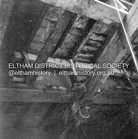
Negative - Photograph, J.A. McDonald, Bridge decking structure, Mar. 1960
Possibly Cherry Tree Road Job 56F443 Contractors Wolf and Wood Old bridge during construction of new bridge March 1960Record of various Shire of Eltham infrastructure works undertaken during the period of 1952-1962 involving bridge and road reconstruction projects, sometimes with Eltham Shire Council Project Reference numbers quoted. It was during this period that a number of significant improvements were made to roads and new bridges constructed within the shire that remain in place as of present day (2022). In many situations, the photos provide a tangible visible record of infrastructure that existed throughout the early days of the Shire. The album was put together by or under the direction of the Shire Engineer, J.A. McDonald.infrastructure, 1960-03, bridge construction, cherry tree road, heidelberg-kinglake road, shire of eltham -
 Greensborough Historical Society
Newspaper clipping, Fiona Cameron, Pioneer bridge is demolished, by Fiona Cameron, 1974_
Describes the removal of the bluestone bridge abutment on the north side of the Plenty River in Greensborough, to make way for the Diamond Creek Road bridge duplication.Photocopy of news articleplenty river, diamond creek road -
 Clunes Museum
Painting, RICHARD FORD, CIRCA 1923
OIL PAINTING FEATURING BRIDGE ACROSS CRESWICK CREEK IN THE STATION FLAT AREA. NORTH WEST OF CLUNES. BRIDGE IS NOW REPLACED BY "FORD".OIL PAINTING BY CLUNES ARTIST RICHARD FORD.local history, illustration, oil, ford richard -
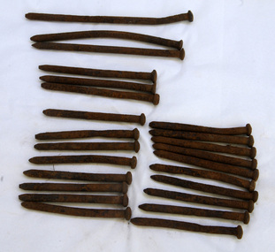 Orbost & District Historical Society
bridge spikes, 1922
These spikes are from the old Snowy River bridge (the second) constructed in 1922 alongside the previous suspension bridge. Its building was a combined effort of the Victorian Railways and the Country Roads Board at a cost of 35,000 pounds. It was replaced in 1976 by the present bridge after several major floods.These items are from a significant piece of infrastructure built in Orbost in the early 20th century. This bridge no longer exists.Twenty-four iron spikes of four different lengths. They are probably hand-made and have round shafts and heads. They are very rusty.snowy-river-bridge bridge-spikes bridge orbost -
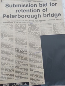 Peterborough History Group
Article - Submission bid for retention of Peterborough Bridge, Cobden Times, 1985
Upon approval of the construction of the new bridge, there was a move to retain the old bridge. It was a very significant connection to the world when first built and it was hoped that all or part of the old bridge could be retained. Town meetings were held and the National Trust approached to enlist their financial support. Significant as it demonstrates the efforts by the townspeople to retain the old bridge.Three and half column newspaper article from the Cobden Times Jan 16th 1985Handwritten at the top is "Cobden Times Jan 16th 1985". With handwritten corrections of names in the article.peterborough, peterborough old bridge, curdies river bridge -
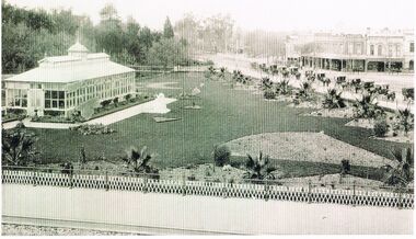 Bendigo Historical Society Inc.
Photograph - BLACK AND WHITE PHOTOGRAPH OF THE CONSERVATORY GARDENS AND SURROUNDING AREA
Black and white photograph of the conservatory gardens and surrounding area. The phot shows the early plantings of the palm trees along the outer fence, and the layout of garden beds waiting to be filled with plants.Just left of centre is a white statue. At the start of Bridge street on the right side there is a line cabs waiting for business. Centre can be seen the bridge over the Bendigo Creek. To the right centre there are a group of retail establishments.bendigo, parks and gardens, conservatory gardens -
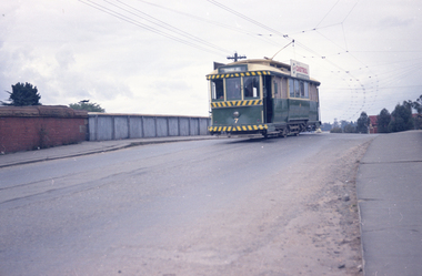 Ballarat Tramway Museum
Negative, Travis Jeffrey, 5/08/1962 12:00:00 AM
Colour Negative No. N406, of the Bendigo No. 7, showing Quarry Hill, crossing over the railway bridge, in Mitchell St with the railway bridge structure in the background. Tram has a Castrol Oil roof advertisement. Photo taken possibly on 5/8/1962. Colour laser printed copy of image stored in box 73. Original negative hires scan and image updated 28/5/2020.In red pen on folder that contained negative, "NR96B" and "5 Aug 62". trams, tramways, bendigo, railway station, mitchell st, tram 7 -
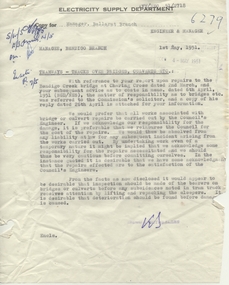 Ballarat Tramway Museum
Document - Letter/s, State Electricity Commission of Victoria (SECV), "Tramways - Tracks over bridges, culverts etc.", Aug. 1957
Yields information about the correspondence that was involving damage to the Charing cross bridge in Bendigo and responsibilities for repair.Memo with attached letter dated 1/5/191, titled "Tramways - Tracks over bridges, culverts etc." regarding repairs to the Bendigo Creek Bridge at Charing Cross and responsibility of costs for repairs - SEC or City of Bendigo. Letter from Dooley and Breen Solicitors, dated 26/4/1951 regarding responsibilities, refer to original agreements. Was pinned the top left hand corner.Has initials in ink.trams, tramways, letters, sec, tram track, pmg