Showing 11033 items matching " land"
-
 Bendigo Historical Society Inc.
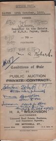
Document - H.A & S.R. WILKINSON COLLECTION: CONDITION OF SALE
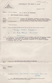
Conditions of sale between private contract issued by H.. Wilkinson and dated 19th October, 1950 between L.B. White, Executor in the estate of K.M.A. Payne (seller) and A. Roberts for land situate No. 18 Hayes Street Bendigo being part of Crown allotment 500A section A Parish of Sandhurst, City and County of Bendigo and being the land remaining in Crown grant volume 6276 folio 1255184, together with 4-roomed weatherboard dwelling and all sundry. Price 835 pounds.organization, business, h.a. & s.r wilkinson real estate -
 Bendigo Historical Society Inc.
Document - MINE SAFETY CAGES & FEDDER DUSTER
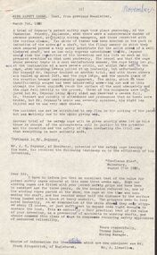
Three pages of extracts titled Mine Safety Cages, Old Bendigonians, memories of 'Fedder Duster', a Chinese Market Gardener; and a book review. The Safety Cage was an invention to stop the cage falling down the shaft if the rope gave way. Fedder Duster was a Chinese Market Gardener who was forced off his garden lease. His name was Ah Louey. The Book Review was 'Land, Labour and Gold' or Two Years in Victoria, with visits to Sydney and Van Diemen’s Land, by William Howitt.document, names of bendigo pioneers, mine safety cages & fedder duster, tasmanian foundry, mr j h seymour, dr stewart, conflecua mine malmsbury, thomas dunne, mr frank fitzpatrick, mr a llewellun, old bendigonians, mr john robshaw, mr hugh mcdevitt, alexander bayne, mr f sciallero, camp reserve, art gallery, hon. w i winter-irvine, george avery fletcher, great central goldfield, dear old bendigo 1892, fedder duster, mrs chancellor, ah louey, market gardener, mr curnow, technical school art class, bendigo benevolent home, joch, land labour and gold 1855, two years in victoria with visits to sydney and van diemen's land, william howitt, lowden publishing co, government camp, stars & stripes of america, odd fellows, freemasons, miss f kingerlee -
 Bendigo Historical Society Inc.
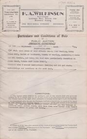
Document - H. A. & S. R. WILKINSON COLLECTION: CONTRACT OF SALE
Conditions of sale by public auction dated 18th March, 1950 between T. Pratt (vendor) and W. & M. G. Spedding (purchaser). Property: land situate Grassy Flat, Bendigo being allotment 218B, Parish of Sandhurst County of Bendigo, containing 2 acres and 26.5 perches, land described in Crown grant volume 3127 folio 625277, together with 5 room weatherboard dwelling and all sundry outbuildings. Price: 800 pounds. Attached 1 hand written note.organization, business, h.a. & s.r wilkinson real estate -
 Bendigo Historical Society Inc.
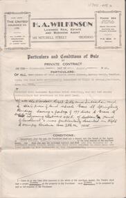
Document - H. A. & S. R. WILKINSON COLLECTION: CONTRACT OF SALE
Conditions of sale by private contract dated 14th August, 1945 between R. D. Bawden (vendor) and Mrs. M. Steel (purchaser). Property: land situate in Grave Street, Spring Gully, having a frontage of 197 links to Grave Street east and adjoining allotment 432E section H, Parish of Sandhurst, land described in right to occupy residence area title No. 7885, together with 4 room Egyptian brick dwelling and all sundry outbuildings. Price: 280 pounds.organization, business, h.a. & s.r wilkinson real estate -
 Bendigo Historical Society Inc.
Document - H. A. & S. R. WILKINSON COLLECTION: CONTRACT OF SALE
Contract of sale of land dated 19th September 1956 between Farmers and Citizens trustees Company Bendigo administrators of the estate of Edith Maud Burrows deceased (vendor) and Mr. G. W. Symons (purchaser). Property: land being allotment 15 section 17B Parish of Sandhurst city of Bendigo, containing 34 perches situated 60 thistle Street referred in right to occupy a residence area no. 006, together with all buildings thereon. Price: 520 pounds.organization, business, h.a. & s.r wilkinson real estate -
 Bendigo Historical Society Inc.
Document - LA TROBE UNIVERSITY BENDIGO COLLECTION: THE BIG LAND PUZZLE10-ACRE MIX UP
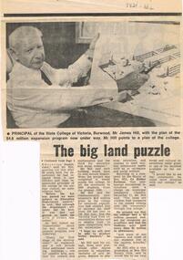
A newspaper article titled 'The Big Land Puzzle: 10-acre mix up'. This relates to a difference of opinion over what a 10 acre site was bought for. The Principal of the State College of Victoria, Burwood Mr. James Mac Hill, said it wasn't bought for a college to train teachers for handicapped children as was reported by The Minister for Education Mr. Lindsay Thompson. The Principal said the land was being acquired by the State College of Victoria, campus. The article includes a photo of Mr. Hill. Gazette, 1974.bendigo, education, state college of victoria burwood, la trobe university bendigo collection, collection, bendigo teachers' college, mr. james mac hill, land development, state college of victoria burwood campus, tertiary education, mr. lindsay thompson, minister of education -
 Bendigo Historical Society Inc.
Document - CONNELLY, TATCHELL, DUNLOP COLLECTION: MORTGAGE MR. GEORGE LADSON TO T. LUXTON
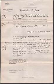
Mortgage document ( 19 August 1892 ) and related correspondence between Mr. George Ladson to Mr. T. Luxton Esq. re purchase of land in Parish of Macorna, County of Gunbower. Includes transfer of land between The Irrigable Estate Coy, to Mr. George Ladson. Letters from Connelly, Tatchell & Dunlop, Thomas Luxton, Irrigable Estate Company, Irrigation & Water supply Trust, George Welch, Railway Hotel, Macorna, draft of document which includes name of John Quick ( unsigned )cottage, miners, george ladson, thomas luxton, john quick, connelly & tatchell, macorna, irrigation and water supply trust, tragowel -
 Kew Historical Society Inc
Photograph - The Boulevard at Kew, 1937
The Yarra Scenic Boulevard stretching from Hawthorn to the Chandler Highway was completed as a major project between 1933 and 1936 during a period of significant unemployment. Key dates in the construction this section the road include: 1933 when Kew Council supported the construction of the road from Studley Park to the Kew Asylum; and 1936 when the road from the Johnston Street Bridge to the Chandler Highway was opened. The inscription on the reverse of the photo 'Boulevard Fairfield' is misleading as there is no section of the Boulevard in Fairfield. A more likely interpretation is that it is a photograph of the Kew section of the Yarra Boulevard with the factories of Fairfield in the distance.Rare early photograph of the Yarra Boulevard, taken one year after the opening of the road. The photograph is an important historical record of the results of 'Susso' labor in the creation of major works in Melbourne by the Victorian Government. Original, black and white positive print of the Boulevard at Kew in 1937. Key aspects to note about the photograph is that the road is bituminised; that the gutters are concreted; that the kerb is constructed of concrete blocks; and that there is an unmade footpath on what appears to be the right hand side of the road. The landscape is sparsely treed, and those trees that remain are presumably remnant vegetation. At the right, the land is fenced. The land at the left falls away sharply to the river below. On the horizon, at left, there is an industrial complex including a tall chimney that is burning fuel creating smoke. "Boulevard Fairfield" great depression, susso projects, roads -- kew (vic.), yarra boulevard, yarra valley -
 Bendigo Historical Society Inc.
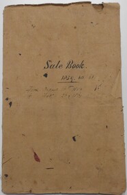
Document - LANDS OFFICE: SANDHURST AND DISTRICT LAND SALES BY PUBLIC AUCTION 1859 - 60
Document: booklet, brown heavy paper cover bound secured with white cotton. Blue paper pages. On front cover ' Sale Book 1859, 60, 61. From August 16th. 1859 to Feb. 26 1861' Contains newspaper cuttings of crown land sales held in Sandhurst. Alongside cuttings are columns: price per acre, amount, purchasers. White sticker fixed to pocket: Book 7 Sandhurst Land Sales 16 August 1859 to March 1861Lands Officebendigo, land sales 1859 - 60, lands office, sandhurst, crown land, auctions -
 Kew Historical Society Inc
Plan, Sydney Arnold Best & Co, Field Place, Kew, c.1929
Pru Sanderson, in her groundbreaking ‘City of Kew Urban Conservation Study : Volume 2 - Development History’ (1988), summarised the periods of urban development and subdivisions of land in Kew. The periods that she identified included 1845-1880, 1880-1893, 1893-1921, 1921-1933, 1933-1943, and Post-War Development. These periods were selected as they represented periods of rapid growth or decline in urban development. An obvious starting point for Sanderson’s groupings involved population growth and the associated economic cycles. These cycles also highlighted urban expansion onto land that was predominantly rural, although in other cases it represented the decline and breakup of large estates. A number of the plans in the Kew Historical Society’s collection can also be found in other collections, such as those of the State Library of Victoria and the Boroondara Library Service. A number are however unique to the collection.The Kew Historical Society collection includes almost 100 subdivision plans pertaining to suburbs of the City of Melbourne. Most of these are of Kew, Kew East or Studley Park, although a smaller number are plans of Camberwell, Deepdene, Balwyn and Hawthorn. It is believed that the majority of the plans were gifted to the Society by persons connected with the real estate firm - J. R. Mathers and McMillan, 136 Cotham Road, Kew. The Plans in the collection are rarely in pristine form, being working plans on which the agent would write notes and record lots sold and the prices of these. The subdivision plans are historically significant examples of the growth of urban Melbourne from the beginning of the 20th Century up until the 1980s. A number of the plans are double-sided and often include a photograph on the reverse. A number of the latter are by noted photographers such as J.E. Barnes.An unnamed subdivision in Studley Park including five lots for sale in Studley Park Road, Highfield Grove and Tara Avenue. Unidentified on the plan, but clearly existing, are the Henty family mansion of Field Place and Tara Hall in Studley Park Road. The first attempted subdivision of Tara Hall was advertised in 1927 in which Lots 5, 6 and 7 in this plan were also advertised. Unusually, Lot 2 in Studley Park Road was created from the northern part of the Henty mansion, rather than Tara Hall. In the subdivision, lots were advertised at varying prices, with the highest price for land being Lot 2 in Studley Park Road. The plan notes that only one villa is to be allowed on each allotment.subdivision plans - kew, field place subdivision -- studley park – kew (vic.), highfield grove – kew (vic.), tara avenue – kew (vic.) -
 Warrnambool and District Historical Society Inc.
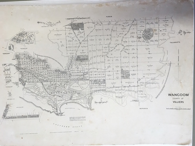
Document: Map, Map Wangoom County of Villiers, 1955
This map contains the names, acreage details and dates of the original property owners of the Parish of Wangoom (County of Villiers), excluding the township of Warrnambool. It also has details of the Crown Lands adjoining the Merri and Hopkins Rivers. This is a most important map as it has details on the original property owners. It is a most valuable research tool and is one of our most-used maps.This is a map, printed in black and white and mounted on cardboard. Where there was intensive land ownership the details have been reproduced in larger print on the margins of the map. There are scuff and dirt marks on the map but it is otherwise in good condition.‘Wangoom, County of Villiers’wangoom, warrnambool, county of villiers -
 Glenelg Shire Council Cultural Collection
Photograph - Photograph - aerial view of Portland coastline, c. 1954
Black and white aerial photograph of coastline around Portland. Black border, scale all sides, 5 rows of 3 't' at regular intervals. 10% ocean, 90% land. See 'Other Information'Front: '820- 52' - handwritten, white, border 'RUN 6' 'PORTLAND', printed, white, borderport of portland, aerial photography, south west coastline -
Glenelg Shire Council Cultural Collection
Photograph - Photograph - aerial view of Portland, c. 1954
Black and white aerial photograph of coastline around Portland. Black border, scale all sides, 5 rows of 3 't' at regular intervals. 25% ocean, 75% land. See 'Other Information'Front: '820 - 50' - handwritten, white, border 'RUN 6' 'PORTLAND', printed, white, borderaerial photography, central portland, portland harbour, south west coastline -
Glenelg Shire Council Cultural Collection
Photograph - Photograph - aerial view of Portland, c. 1954
Black and white aerial photograph of coastline around Portland. Black border, scale all sides, 5 rows of 3 't' at regular intervals. Mostly ocean, small area of land lower left.Front: '820-6' -- handwritten, white, lower border 'RUN 5' 'PORTLAND', printed, white, lower borderaerial photography, central portland, portland harbour, south west coastline -
Glenelg Shire Council Cultural Collection
Photograph - Photograph - Aerial photograph of coastline around Portland, Victoria, c. 1954
Black and white aerial photograph of coastline around Portland. Black border, scale all sides, 5 rows of 3 't' at regular intervals. Bottom 20% ocean, rest land, separated by beach.Front: '607 - 88' - handwritten, white, border 'RUN - 6 PORTLAND', printed, white, border -
Glenelg Shire Council Cultural Collection
Photograph - Photograph - aerial view of Portland, c. 1954
Black and white aerial photograph of coastline around Portland. Black border, scale all sides, 5 rows of 3 't' at regular intervals. Mostly ocean, small area of land, top left.Front: '607 - 49 ' - handwritten, white, border 'RUN 8' 'PORTLAND', printed, white, borderaerial photography, central portland, portland harbour, south west coastline -
Glenelg Shire Council Cultural Collection
Photograph - Photograph - aerial view of Portland, c. 1954
Black and white aerial photograph of coastline around Portland. Black border, scale all sides, 5 rows of 3 't' at regular intervals. Mostly ocean, small area of land, top centreFront: '607 - 50 ' - handwritten, white, border 'RUN 8' 'PORTLAND', printed, white, borderaerial photography, central portland, portland harbour, south west coastline -
Glenelg Shire Council Cultural Collection
Photograph - Photograph - aerial view of Portland, c. 1954
Black and white aerial photograph of coastline around Portland. Black border, scale all sides, 5 rows of 3 't' at regular intervals. Bottom third is ocean, the rest is land, separated by beach.Front: '607 - 89 ' - handwritten, white, border 'RUN - 6 PORTLAND', printed, white, borderaerial photography, central portland, portland harbour, south west coastline -
Glenelg Shire Council Cultural Collection
Photograph - Photograph - aerial view of Portland, c. 1954
Black and white aerial photograph of coastline around Portland. Black border, scale all sides, 5 rows of 3 't' at regular intervals. Bottom half ocean, top land, separated by beach.Front: '607 - 92 ' - handwritten, white, border 'RUN - 6 PORTLAND', printed, white, borderaerial photography, central portland, portland harbour, south west coastline -
Glenelg Shire Council Cultural Collection
Photograph - Photograph - aerial view of Portland, c. 1954
Black and white aerial photograph of coastline around Portland. Black border, scale all sides, 5 rows of 3 't' at regular intervals. Small strip of land across bottom. The rest is ocean.Front: '607 - 56 ' - handwritten, white, border 'RUN 7 PORTLAND', printed, white, borderaerial photography, central portland, portland harbour, south west coastline -
 Halls Gap & Grampians Historical Society
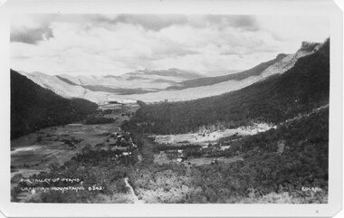
Postcard - B/W
Photo on card was taken by Gilbert Rogers, a photographer and tour guide during the 1930s. This postcard is one of a series.Depicts as valley with mountains on both sides. Cleared land can be seen on either side of a road which runs through the valley. Buildings are also visible in middle area. View is running south-west.scenery, fyans valley -
 Federation University Historical Collection
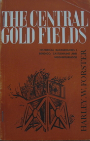
Book, Harley W. Forster, The Central Goldfields, 1969
Brown covered book of 80 pages. Topics include gold, McIvor diggings, Tarrangower goldfields, Maldon, quartz reefs, Chinese, land selection, Mt Alexander, Castlemaine, gold licence agitation, glossary. gold license, gold licence, castlemaine, goldfield agitation -
Federation University Historical Collection
Exercise Book, William Baragwanath, William Baragwanath's Exercise Book, 1898, 1898
William Baragwanath studied at the Ballarat School of Mines, obtained a Geology certificate in 1911. He was born on 01 August 1878 at Ballarat. He joined the Victorian Department of Mines in 1897 and was Chief Mining Surveyor from 1924 to 1943. Baragwanath died at Prahran on 20 Septemeber 1966.Marbled blue card covered exercise book with yellow tape spine containing handwritten notes by William Baragwanath on dividing land problems, earthworks, refraction, etc; Headings include: Tom Joe Smith ballarat school of mines, earthworks, land problems, refraction, william baragwanath, -
Glenelg Shire Council Cultural Collection
Photograph - Photograph - Main Breakwater construction, Portland, n.d
Port of Portland Authority Archivesport of portland archives, main breakwater, construction, portland, harbour, harbour development -
 Bendigo Historical Society Inc.
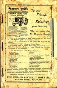
Book - ERROL BOVAIRD COLLECTION: NEW SETTLERS' HANDBOOK TO VICTORIA
Book titled 'New Settlers' Handbook to Victoria. Book contains information of the State of Victoria, Welcoming the New Australian, The Farm Learner, Settling on the Land, The Settler's Home, The 'N.S.L.' Districts and a Buyers' and Sellers' Directory.New Settlers League of Australia3john bovaird collection - new settlers' handbook to victoria, the herald & weekly times ltd, the honorable john allan mla, new settlers league of australia (victorian division), archibald gilchrist -
 Bendigo Historical Society Inc.
Document - CURNOW COLLECTION: FORM DEED OF DEFEASANCE, 19??
'Deed of Defeasance under Mutual Rule . Residence Area Title (Miner's Right). The Bendigo Mutual Permanent Land and Building Society. Four page blank (unused) form. Printer: Cambridge Press Print.Cambridge Press Printperson, individual, curnow collection -
Port Melbourne Historical & Preservation Society
Document - Correspondence re purchase of land by Port Melbourne Council for new Electricity Supply Depot, City of Port Melbourne, 1976
Correspondence etc concerning PMCC's attempt to purchase land for a new Electricity Supply depot in 1976. This paperwork was retained by the City Valuer, Mr Frank Julier, who served in that post from around 1974local government - city of port melbourne, built environment, f l julier - city valuer -
Port Melbourne Historical & Preservation Society
Document - SCDC Report, Ewan Ogilvy's Bayside Papers Box One, 1987 - 1998
Ewan Ogilvy, former Melbourne Councillor and also of Community Services Victoria, Inner Urban Ministerial Advisory Committee and Uniting Church's Centre for Urban Research and Action (CURA), was instrumental in social justice approaches to town planning. He and CURA's Social Justice and the City Project funded Port Melbourne community groups protesting against the SCDC development in 1987. His files were presented to the Society in May 2001 on his preparation for leaving Victoria.From Ewan Ogilvy's chronologically organised 'Bayside Papers' relating to the proposed development of Port Melbourne industrial land in the late 1980s: Extra photocopies of all documents in 1390.06, bound only with bulldog clipAll items signed 'Ewan Ogilvy'town planning, town planning - proposals shelved - bayside, public action campaigns, environmental issues, public housing, ewan ogilvy, centre for urban research and action, sandridge city development co pty ltd, scdc, tom roper, evan walker -
Port Melbourne Historical & Preservation Society
Document - Vendors Statement for the sale of Lot 35 Beacon Cove, Port Melbourne, 1996
Lot 35 is now titled 18 Park Square, Beacon Cove, Port MelbourneFolder with pale green cover and black spiral binding. Folder contains Vendors Statement to the Purchaser of Real Estate pursuant to Section 32 of the Sale of Land Act 1962 for Lot 35 Beacon Cove.built environment - domestic, department of planning and development, park square, beacon cove, mirvac -
Clunes Museum
Document - DOCUMENTS
.1 DATED 12/05/1926 ACCOUNT FOR FUNERAL ARRANGEMENTS FOR HARRIET RICHARDS FROM W BARKELL UNDERTAKER .2 COPY OF TITLE OF LAND SITUATED SMEATON RD., CLUNES FOR JAMES WILLIAMS OF SMEATONw. barkell, harriet richards, james williams of smeaton