Showing 10387 items
matching plan
-
 Federation University Historical Collection
Plan - Plan (copy), Melbourne Road Ballaarat, 1857
This map shows the vicinity of the site of the Eureka Stockade. A3 black and whole photocopy of a plan of Ballarat's Melbourne Road. The plan shows Melbourne Road, Proposed Melbourne Road (later Eureka Street), Chamberlain Street, Queen Street, Allotments between Rodier Street and Stawell Street (William Collard Smith, J & T Oddie, F.A. Edward A. Wynne, David Fitzpatrick, Robert Walsh, Charles Spencer, Alfred Lester, Free Trade Hotel)william collard smith, oddie, wynne, fitzpatrick, walsh, spencer, lester, free trade hotel -
Port Melbourne Historical & Preservation Society
Plan - Liardet Memorial, Sinclair Parade, Port Melbourne, Peter Christoff, Architect, Proposed Liardet Monument for City of Port Melbourne, Aug 1987
Given to donor, source unknown. Monument itself was designed by local architect Peter CHRISTOFF as Port's Bicentenary project; utilises bluestone from the demolished Sugar Works property, later Harper's(.01)Photocopy of plan for Liardet Memorial in Sinclair Parade, Port Melbourne's 1988 Bi-Centennial project designed by Richardson Christoff Architects for Port Melbourne Council (.02) Proposed Liardet monument working drawing. February 1988. Richardson Christoff P/L (.03) Plan of proposed garden for Liardet monument (.04) Correspondence Port Melbourne City Council and Port Melbourne BiCentennial Committee Title has been highlighted in orangebuilt environment - civic, architecture, celebrations fetes and exhibitions, peter christoff, richardson christoff architects, wilbraham frederick evelyn liardet, wfe liardet -
 Ballarat Tramway Museum
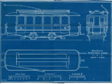
Plan, Ken McCarthy, "NSWGT - Electric trams 1,2,3 1890 - 1900", May. 1960
Yields information about the nature of the trams that came from Sydney to Ballarat for the first electric tramcars and has a strong association with the person who prepared by the plan.Blueprint plan of NSW Govt. Tramway cars 1,2,3,- Roof plan, front and side elevation - with side running trolley poles - 3/8"=1' scale with O gauge 1/4 and O gauge 3/8" scale marked. (These cars become part of the 1905 ESCo Ballarat Fleet). Imaged by scanning in two halves and joining together - could do some further work.trams, tramways, nswgt, plans, tramcars, esco -
 Melbourne Tram Museum
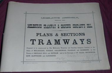
Document - Folder, Jack Cranston, "Melbourne Tramway & Omnibus Company's Bill - Plans and Sections - Tramways - March 1882", 1994
Consists of five sheets with notes about the proposed horse tram system for Melbourne, prepared by Jack Cranston. Includes extract and notes on the parliamentary enquiry and the possibility of a cable tram system. The coloured sheet is from another copy held at the former VicTrack Malvern Museum. Images from the latter set of documents - Sept 2024. 35 Sheets of details on the plans and sections of proposed horse tram lines throughout Melbourne. Produced as part of the work undertaken by Jack Cranston for the Department of Transport / Heritage Victoria - see Reg Item 584. On rear cover ink and on page 2 of the folder is a note on the source of the document. See Inscriptions.Yields information about the proposed horse tram lines by MTOCo that were later developed as cable tram lines.Folder - photocopies or copy prints, A1 approx. size, 45 sheets, clipped together with two black side binders, titled - "Melbourne Tramway & Omnibus Company's Bill - Plans and Sections - Tramways - March 1882". On rear cover sheet, handwritten in black ink - "Constructed and compiled by Jack Cranston by permission from The Ambleside Museum Ferntree Gully Victoria. This is a copy of Original Size Folio"trams, tramways, cable trams, horse trams, mto co, melbourne -
 Port Melbourne Historical & Preservation Society
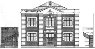
Plan - North west elevation, Port Melbourne Town Hall, Port Melbourne City Council, 1915
Plan - new (1915) Town Hall Port Melbourne, north west elevation, lonitudinal section A-A. Front elevation. Cross section B-B, Section C-C.port melbourne town hall -
University of Melbourne, Burnley Campus Archives
Plan, 'Burnley Park', 1987
Tracing paper copy dated July 1987. Landscape Graphics - Assignment One, 'Burnley Park' Site Plan. Scale 1:100. Includes contours and existing trees.burnley park, trees -
University of Melbourne, Burnley Campus Archives
Plan, Nicole Faulkner, Rose Garden 'Banyule', 1989
Planting Plan for 'Banyule', 72 Buckingham Drive, Heidelberg by Nicole Faulkner for Grad. Dip. Horticulture. Sheet 4 of 4, dated November 1989. Scale 1:100.rose garden, nicole faulkner, "banyule", heidelberg -
 University of Melbourne, Burnley Campus Archives
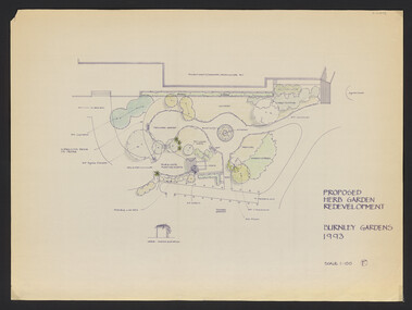
Plan, Jill Kellow, The Herb Garden V.C.A.H. Burnley, 1993
Was held in Phil Tulk's office. Proposed Herb Garden redevelopment Burnley Gardens 1993 (probably drawn by Jill Kellow). Scale 1:100. Also hand drawn rough plan of the position in the gardens. herb garden, phil tulk, andrew smith, jill kellow -
Port Melbourne Historical & Preservation Society
Plan - Handcoloured identification of wood and brick buildings, hotels and lanes on copy of a section of MMBW map, 1930s
Given to Peter LIBBIS, who hand ocloured legend etc. while researching his house and family, then donated to society in 1997.Photocopy of MMBW plan 326 - block between Stokes and Princes, Rouse and Graham. Colour coded for brick or wood builidngs, lanes marked in green and four hotels indicated.As abovehotels, religion - roman catholic church (st josephs), built environment, peter libbis -
 University of Melbourne, Burnley Campus Archives
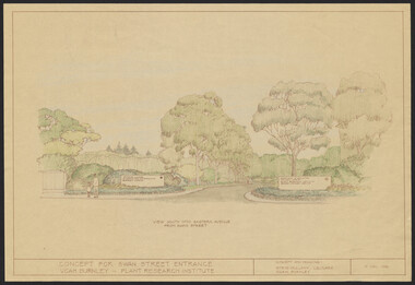
Plan, Concept for Swan Street Entrance. VCAH Burnley - Plant Research Institute, 1988-1998
(1) Concept and Drawing by Steve Mullany, Lec turer V.C.A.H. Burnley 9 Dec 1988. Handdrawn. 1 coloured, 2 copies and 4 tracing paper sketches. (2) Landscape Plan by Steve Mullany 3 Feb 1989. Handdrawn. Includes Plant Plan. 2 copies on tracing paper. 3 copies original on paper with some additional notation. (30 Project Eden, Swan Street, Richmond - Landscape Plan LA2 Project No 682 by Mark McWha Pty Ltd Nov 1997. Photocopy. Includes Irrigation and Plant Schedule. (4) Swan St Frontage Planting Scheme by P. Tulk for AMRAD. Coloured. 19/2/1998. -
University of Melbourne, Burnley Campus Archives
Plan, Albert Park, c.1994
Plans of sections of Albert Park by The Hassell Group, Lead Consultant Land Systems EBC, Melbourne Parks & Waterways. 1 copy laminated of each of: (1) 2 copies Albert Park Golf Course Proposal. (2) Ross Gregory Drive Precinct. (3) Lakeside Drive May 1994. (4) 2 copies New South Melbourne Soccer Ground. (5) 2 copies Aughtie Drive. (6) 2 copies Aughtie Drive Precinct. (7) 2 copies New Home for South Melbourne Cricket Club. (8) Final Proposed Strategy Plan: Realising the Vision, coloured, Key features of the plan on reverse. -
 Kew Historical Society Inc
Plan - Subdivision Plan, St Helliers Estate, Kew, circa 1910, c.1910
Pru Sanderson, in her groundbreaking ‘City of Kew Urban Conservation Study : Volume 2 - Development History’ (1988), summarised the periods of urban development and subdivisions of land in Kew. The periods that she identified included 1845-1880, 1880-1893, 1893-1921, 1921-1933, 1933-1943, and Post-War Development. These periods were selected as they represented periods of rapid growth or decline in urban development. An obvious starting point for Sanderson’s groupings involved population growth and the associated economic cycles. These cycles also highlighted urban expansion onto land that was predominantly rural, although in other cases it represented the decline and breakup of large estates. A number of the plans in the Kew Historical Society’s collection can also be found in other collections, such as those of the State Library of Victoria and the Boroondara Library Service. A number are however unique to the collection.Subdivision plans are historically important documents used as evidence of the growth of suburbs in Australia. They frequently provide information about when the land was sold on which a built structure was subsequently constructed as well as evidence relating to surveyors and real estate and financial agents. The numerous subdivision plans in the Kew Historical Society's collection represent working documents, ranging from the initial sketches made in planning a subdivision to printed plans on which auctioneers or agents listed the prices for which individual lots were sold. In a number of cases, the reverse of a subdivision plan in the collection includes a photograph of a house that was also for sale by the agent. These photographs provide significant heritage information relating house design and decoration, fencing and household gardens.In the subdivision of part of Crown Portion 82, bordered by John and Sackville Streets and Cotham and Burke Roads, over 100 lots were offered for sale. In addition to the designated lots, a number of key locations are also identified. These include the Genazzano Convent to the north of Cotham Road, the Reservoir, St Hilary’s and the land holding of Colonel Parnell on the corner of John Street and Cotham Road. On the Plan, No. 5064, is the handwritten name ‘St. Hellier’s Estate’. St. Helliers, the home of the Dumaresq family is shown beside St. Hilary’s.subdivision plans - kew, st helliers estate -
 Ringwood and District Historical Society
Pamphlet, Subdivisional Auction Sale, Bedford Park, Ringwood - 1924
Bedford Park subdivisional development did not eventuate. The land adjoining the railway line became parkland with provision for sporting facilities and the remainder was purchased by the Education Department as the site for Ringwood High School/Secondary College. Double sided bifolded auction sale advertisement including subdivision features and local facilitiesSubdivision plan includes Bedford Road, Graham Road, Joyce Street, Anderson Street, and Adams Street -
 Ringwood and District Historical Society
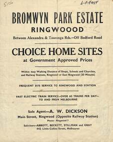
Flyer, Bromwyn Park Estate, Ringwood - 1946 - Avertising Brochures and Map
Two pages of subdivision features, services and locationSubdivision plan includes Alexandra Road, Marwarra Street, Tooronga Road, Hilary Grove, Morcom Avenue. -
 Federation University Historical Collection
Map, Ballarat and Sebastapol Gold Mines, Late 19th Century
colored printed map on paper lined onto linen backingprinted "Rider & Mercer's Plan of the Ballarat & Sebastapol Gold Mines Scale 30 Chains to One Inch"gold mines, mine allotment map, mining leases, ballarat, sebastopol, rider and mercer, golden shaft co, prince of wales and bonshaw united, leviathan gold mines, holst and co, speedwell co, sebastopol plateau, rothschild co, tower hill co, south plateau, south star co, band of hop and albion consols, prince regent co, chenhall and co, despza, buninyong estate, one eye hully, winter's freehold, luplau plateau, e. morey, carrill's quartz -
 Wodonga & District Historical Society Inc
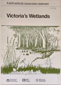
Book - Victoria's Wetlands, Dept. of Conservation, Forests & Lands, 1986
This publication was the result of an inquiry into the state of wetland environments in Victoria. It produced a draft strategy for conservation of threatened areas in the future.An 22 page book containing maps and illustrationsThis publication was the result of an inquiry into the state of wetland environments in Victoria. It produced a draft strategy for conservation of threatened areas in the future.wetland protection, wetlands victoria, water conservation -
 Kew Historical Society Inc
Plan - Subdivision Plan, Violet Farm Estate, 1927
Pru Sanderson, in her groundbreaking ‘City of Kew Urban Conservation Study : Volume 2 - Development History’ (1988), summarised the periods of urban development and subdivisions of land in Kew. The periods that she identified included 1845-1880, 1880-1893, 1893-1921, 1921-1933, 1933-1943, and Post-War Development. These periods were selected as they represented periods of rapid growth or decline in urban development. An obvious starting point for Sanderson’s groupings involved population growth and the associated economic cycles. These cycles also highlighted urban expansion onto land that was predominantly rural, although in other cases it represented the decline and breakup of large estates. A number of the plans in the Kew Historical Society’s collection can also be found in other collections, such as those of the State Library of Victoria and the Boroondara Library Service. A number are however unique to the collection.The Kew Historical Society collection includes almost 100 subdivision plans pertaining to suburbs of the City of Melbourne. Most of these are of Kew, Kew East or Studley Park, although a smaller number are plans of Camberwell, Deepdene, Balwyn and Hawthorn. It is believed that the majority of the plans were gifted to the Society by persons connected with the real estate firm - J. R. Mathers and McMillan, 136 Cotham Road, Kew. The Plans in the collection are rarely in pristine form, being working plans on which the agent would write notes and record lots sold and the prices of these.The subdivision plans are historically significant examples of the growth of urban Melbourne from the beginning of the 20th Century up until the 1980s. A number of the plans are double-sided and often include a photograph on the reverse. A subdivision plan for nineteen ‘bonny, airy building blocks’ on either side of Violet Grove, Kew East. Violet Grove runs between High Street and Harp Road. Like many other subdivisions in Kew and East Kew, older houses (Lots 1 and 13) were often included in the subdivision. Such houses were in some instances the original properties that were subdivided, or in the case of the Violet Grove subdivision, new houses such as the weatherboard villa on lot 13. This villa is advertised as having a tiled roof, 5 rooms, panelled hall, double doors (Rooms 14 x 12 ft. 6 in. (2) 14 x 12, 12 x 11, 13 x 11). A bricked front verandah, a tiled stove recess and existing sewerage connection added to its saleable potential. Water, electric light and power, and gas were all offered as part of the deal. Violet Grove now has about 35 houses, which indicates that the 19 lots of the subdivision were to be further subdivided by purchasers. [A similar plan is in the Batten & Percy Collection of the State Library of Victoria.]subdivision plans - east kew, violet farm estate, violet grove -- kew (vic.), boorool road -- kew (vic.), harp road -- kew east (vic.) -
Federation University Historical Collection
Plans, Ballarat School of Mines architectural plans, 1 - .2) 1984 .3) 1948
.1) Printed plan: Ground floor existing Ballarat East Free Library .2) As above .3) Copy of plan drawing: Additional room to plumbing shop[ plans, smb, g macgregor, percy everett, plumbing, ballarat east library, ballarat school of mines -
Federation University Historical Collection
Report, Emma Nuttall, Goldfields Consultancy Proposal, 2002-5, 1995
.1) Strategic Plan for Goldfields Region: Consultancy Proposal .2) A Strategic Marketing Plan by four students of Tourism at the University of Ballarat relating to Victoria's Goldfields Region.victorian tourisim industry, tourism, goldfields, victorian goldfields -
Port Melbourne Historical & Preservation Society
Document - Specification, Metalling and chanelling, Rouse Street between Esplanade East and Esplanade West, Engineering Department, Town of Port Melbourne, 14 Mar 1893
Specification for tram and road works in Rouse Street between Esplanades East and West and adjacent to Lagoon Loan Works 1893 plan 19; relates to plan 99.2.Signed by JJ Bartlett (Mayor) 14.3.1893engineering - roads streets lanes and footpaths, sandridge lagoon, transport - tramways, arthur victor heath, town clerks, james john bartlett, mayors -
Port Melbourne Historical & Preservation Society
Document, Melbourne and Metropolitan Board of Works, 31 Oct 1935
Documentation of drainage works in 1935 for 141 Bridge St.Plan of drainage 31/10/1935. Details the Melbourne and Metropolitan Board of Works drainage plan for part of Port Melbourne. 141 Bridge St, Port MelbourneHand written details around blueprint of area. Notes made on right hand side and 3 signatures at the bottom.built environment - civic, built environment - domestic, engineering - board of works, melbourne and metropolitan board of works, mmbw, m h grover, r f bentley -
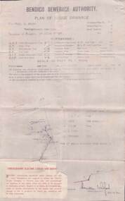 Bendigo Historical Society Inc.
Document - L. PROUT COLLECTION: PLAN OF HOUSE DRAINAGE
Bendigo Sewerage Authority, Plan of House Drainage. For Mrs. C. Prout, weatherboard property situated at 24 Quick Street. The plan is dated 30/10/1930.organization, public utility, water -
Bendigo Historical Society Inc.
Document - MARKS COLLECTION: ALTERATIONS TO FORTUNA VILLA FOR G. LANSELL
Copy of plan: Proposed alterations to Fortuna House (not Villa) for G. Lansell Esq. Plan shows stairway, building. Scale 1/4 inch - 1 foot.buildings, house, fortuna villa -
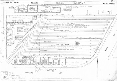 Melbourne Tram Museum
Drawing, Melbourne & Metropolitan Tramways Board (MMTB), "Kew Depot", c1938
Photocopied plans or drawings on A3 sheet of "Kew Depot 22/9/1938 P8400 - Plan of land and buildings - with some 1967 notes shows substation location.trams, tramways, drawings, depots, property, kew, substation -
Whitehorse Historical Society Inc.
Document, Eastern Freeway Extension, 2000 - 2002
Eastern Freeway ExtensionEastern Freeway Extension- Cost estimates for community consultation option Public consultation process : report on analysis submissions Deep Creek Road - Landscape concept Media Release from Premier of Victoria VicRoads - Works update newsletters Whitehorse City Council minutes VicRoads Correspondence Schwerkolt Cottage Precinct - Concept Plan VicRoads maps.Eastern Freeway Extensioneastern freeway extension, vicroads, victoria. department of infrastructure, city of whitehorse, schwerkolt cottage, landscape planning, maps -
Glen Eira Historical Society
Plan - Masonic Hall St Georges Rd, 17, Elsternwick
Handrawn floor plans by FJ Maskell undated of the two floors of the Masonic Hall at 17-19 St Georges Rd Elsternwick with cover letter to Mr Scott. Additional handwritten notes added to the floor plans and letter, author unknown.masonic hall, st georges road, scott wv, maskell fj, plans, elsternwick, halls -
Bialik College
Plan (item) - Extensions to Bialik College, c. 1990s and 2002
Plans for extensions to Bialik College, 429 Auburn Rd, Hawthorn, created by Ron Unger & Associates Architects, c. 1990s. Includes a plan for the new Primary School playground, 2002. Please contact [email protected] to request access to this record.1990s -
Port Melbourne Historical & Preservation Society
Plan - Landscaping Westport Reserve, Port Melbourne, Graeme Bentley, Apr 1990
Plans for landscaping to complement Sandridge Life Saving ClubWorking drawings for landscaping Westport Reserve, Port Melbourne, 5pp, 1990'received 07 Jun 1991'natural environment - beaches and foreshore, westport reserve, bentley, graeme -
 Warrnambool and District Historical Society Inc.
Ledger, Chadwick Copying Book Co, Letter book 1905, 1902
This letter book has maps, letters and plans dating from 1902 to 1905. It came from the office of John William Crawley, Junior, an engineer, architect and surveyor in private practice in Warrnambool and also the engineer for the Shire of Warrnambool from 1895 to 1935. His father, brother and son were all engineers and worked in that capacity or as Shire Secretary for the Shire of Warrnambool, with the Crawley family recording a total of 132 years of service to the Shire of Warrnambool. The Shire of Warrnambool existed from 1863 to 1994. This letter book was passed on to John Crawley’s son, Rolf, engineer for the Shire of Warrnambool from 1935 to 1968. The letter book then came into the possession of Michael Hand who took over the private surveying business of Rolf Crawley in Warrnambool. The Warrnambool and District Historical Society acquired the letter book, along with several other Crawley ledgers, from the Michael Hand estate. This letter book is of considerable importance as it contains the letters, maps and plans produced by John William Crawley Junior, a Shire of Warrnambool engineer for 40 years. It will be useful to researchers. This is a black hard cover letter book of 505 pages, plus an alphabetical index at the back of the book. The letter book contains handwritten letters, sketch maps and plans. There is gold lettering on the spine.‘1’ ‘Invoice’ ‘Chadwick Copying Book Co. Springfield Mass.’ john william crawley, junior, warrnambool, rolf crawley, warrnambool, shire of warrnambool, history of warrnambool -
Glenelg Shire Council Cultural Collection
Administrative record - Administrative record - Parking Plans, Edgar Street Heywood, n.d
'Bower Bird' Museum, HeywoodParking plan for Edgar Street Heywood- Parallel Parking