Showing 7711 items matching "cans"
-
 Ballarat Tramway Museum
Sign, State Electricity Commission of Victoria (SECV), "SEC DANGER HT"
Enamelled metal sign with circular ends and two large and protected mounting holes. With red background & lettered "sec danger ht" in white paint. Has a black enamelled back. Black paint by letter "c" and below it. Letter "h" missing due to damage & a punch mark- like a large can opener mark.trams, tramways, secv, power supply -
 Kew Historical Society Inc
Album - Scrapbook, Eva Grant, Historic Buildings, Kew, 1958-78, 1970s
One of three scrapbooks of photographs and newspaper cuttings taken and or collected by Eva Grant, a past member of the Kew Historical Society, which were donated by her niece, Julie Thomson. The albums include many photographs of Kew from the 1950s to the 1970s. Buildings included in the scrapbook include: Billy Hughes' house - 167 Cotham Road Congregational Church - Walpole Street (c.1978) Country Roads Board - Denmark Street (1960) Dorothy Rogers Reserve - Studley Park Road Ellsmere (also Ellesmere/Ellsmore) - Princess Street Field Place - 3 Henty Court Fernhurst - 13 Fernhurst Grove Kew Civic Centre (1959) Kew Junction (1958) Kew Railway Station (1902, 1959) Kew Recreation Hall - Wellington Street (1960) Neama (Hall) - Studley Park Road Southesk (formerly Ordsall) - Cotham Road (c.1960) St Anthony's Home for Babies (formerly Madford) - 43 Wellington Street (c.1976) Studley House - Nolan AvenueThe scrapbook contains historically significant, rare and sometimes unique images of significant heritage buildings in Kew, including their erection and demolition. 11-page scrapbook of photographs and newspaper clippings with annotations by Eva Grant, a past member of the Kew Historical Society. The pages of the album can be viewed in the image carousel above. Based on the text and known dates of demolition of a number of the buildings, the scrapbook was assembled over a twenty year period between c.1958-c.1978.Includes letter from donoreva grant, billy hughes' house - 167 cotham road, congregational church - walpole street - kew, country roads board - denmark street - kew, dorothy rogers reserve - studley park road - kew, field place - 3 henty court - kew (vic), ellsmere (also ellesmere/ellsmore) - princess street - kew, fernhurst - 13 fernhurst grove - kew (vic), kew civic centre - civic drive - kew (vic), kew junction - kew (vic), kew railway station - denmark street - kew (vic), recreation hall - wellington street - kew, neama - hall - studley park road - kew (vic), southesk - ordsall - cotham road- kew (vic), st anthony's home for babies - madford - 43 wellington street (vic), studley house - nolan avenue - kew (vic) -
 Kew Historical Society Inc
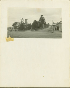
Photograph - Entrance to the Boroondara General (Kew) Cemetery, E.J. Dower, 1913
One of a series of photographs, taken by Edgar James Dower in the second decade of the twentieth century. Born and raised in Olinda, his family later moved to Surrey Hills. He worked as an adult as a clerk in the city office of the Metropolitan Gas Company, and in his role as a 'collector', he was able to photograph scenes including the construction of tramlines and associated buildings in Kew, Hawthorn, Camberwell and Surrey Hills. Later he established a real estate agency with his brother - the E.J. Dower Real Estate Agency, Dandenong Office.The image is an historically significant record of the development of transport infrastructure which was used to connect Victorians in the first two decades of the twentieth century. This development resulted from increases in population and the consequent extension of Melbourne's suburbs. The photographs, both individually and collectively, richly detail the labour of workers and the tools and machinery used to create and extend Melbourne's tram network in the years preceding and during World War 1.Digital copy of an original mounted photograph showing the entrance to the Boroondara General (Kew) Cemetery in 1913. The entrance was/is on the corner of High Street and Parkhill Road. The horse drawn tram from Victoria Street Bridge to the Cemetery can be seen to the left of the photo in High Street. Note also the extensive bluestone gutters in Parkhill Road.Annotated verso: "Entrance to Kew Cemetery? / 1913"theme --- travelling by tram, theme -- connecting victorians by transport and communications, trams -- kew (vic.), high street. -- kew (vic.), parkhill road -- kew (vic.) -
 Kew Historical Society Inc
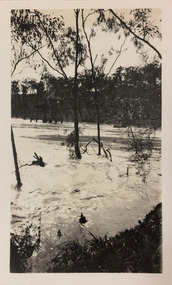
Photograph - Flood, Zig-Zag, Kew, 1924
Henry Beater Christian (1886-1962) , was a descendant of one of the earliest settler families in Kew. Employed at the Kew Asylum as a 'public servant', he was a skilled amateur photographer, photographing numerous scenes in Kew and on his travels around Victoria. The majority of his photographs date from 1916 to 1929. His finest photographs are housed in two photograph albums. Digital copy of a photograph from page 5 of the 47-page photograph album containing 261 gelatinous silver images, loaned by Diane Washfold with permission given to digitise and hold a copy in our collection. This is a photograph of the river at Kew during a flood in January 1924. A section of the Zig-Zag Bridge can be seen in the distance. "Flood / Zig-Zag Kew / 1.24"henry beater christian (1886-1962), landscape photography, kew (vic.) — yarra river, christian-washfold collection, photograph albums, floods -- yarra river -- kew (vic.), zig-zag bridge -
 Surrey Hills Historical Society Collection
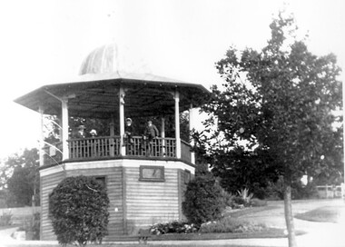
Photograph, John Gray Memorial Rotunda, Surrey Gardens, Photograph by Vic Bowen in 1912
This was erected in 1912 by the Surrey Hills Progress Association to commemorate "one of Surrey Hills most highly respected and revered citizens". The rotunda was demolished in the 1970s. A bronze plaque in tribute to John Gray is now on a stone cairn in the gardens. John Gray was a local citizen very active in community affairs who had died in 1909. The Brass Band rehearsed in the room below which also became a meeting room for many local groups.B&W photocopied image of the John Gray Memorial Rotunda in the Surrey Gardens. The octagonal rotunda has a distinctive domed cupola and is elevated on an enclosed timber base graduated to the slope of the site. A door and 2 windows can be seen in the exposed faces of the base. A group of 4 boys sit on or stand behind the timber railing.surrey gardens, john gray memorial rotunda, rotundas, parks and reserves, gray, john, surrey hills progress association -
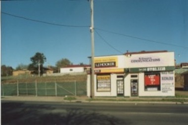 Kilmore Historical Society
Photograph, 5 Sydney Street, 2006?
This photograph is the same property as seen in PHO-00010.15cm x 10cm colour photograph of the building on 5 Sydney Street, which at the time of the photograph is occupied by an L.J. Hooker and Kilmore Communications. The vacant lot adjacent to the building can been seen. Printed on matte standard photographic stock. Kodak and Fuji film brand. 2 photographs with different views from the street.real estate agents, construction sites -
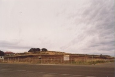 Kilmore Historical Society
Photograph, Sydney Street & Clarke Street
15cm x 10cm coloured photograph of the construction site on the corner of Sydney Street and Clarke Street. The site is now Coles Supermarket, Aldi, Liquorland, McDonalds, Coles Express, Kilmore Pizza Factory. Multiple photos taken over a period of time before the structure was being built. Brewery Hill can be seen in the backgroundWritten on the back: Site being prepared for the new Coles buildingconstruction, supermarkets -
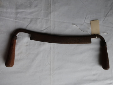
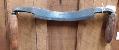 Mont De Lancey
Tool - Draw Knife, ROBT SORBY AUS STEEL, Unknown
A steel curved bladed woodworking tool with two wooden handles used to remove thin slices and big chunks of wood from timber. It can be used to fashion wooden sculptures, debarking trees and trimming beams. The final finishing on such work was done by a Spoke Shave tool which we also have in our collection.ROBT SORBY AUS STEELwoodcarving tools, drawing knives, shaves, handtools, steel, wood, woodworking tools -
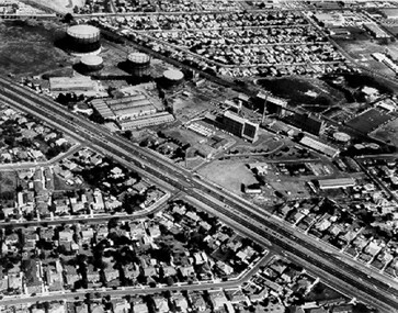 City of Kingston
Photograph - Black and white, c. 1970
The Highett Gas Works were a landmark along the Nepean Highway for many years. With the cessation of the gasification of coal and the introduction of natural gas to Victoria, the gas holders were demolished and the Sir William Fry Reserve was developed on the southern end of the site. The Gas and Fuel redeveloped the northern end of the site with modern offices and laboratories for the organisation's scientific services. At this time, the chimney and retort house were retained.The Highett Gasworks had its beginning in 1939 operated by the Central Brighton and Moorabbin Gas Co Ltd. The company had expanded its gas production facilities to Highett where it had purchased 45 acres of land adjacent to the Melbourne-Frankston railway line. The first gasholder was erected on the Highett site in 1927 and connected with high pressure mains to the Brighton Gas Works. In 1939 the building program including gasometers, the vertical retort house and coal store was completed and gas making commenced. Its area of supply covered approximately 70 square miles and included the municipalities of Brighton, Sandringham, Moorabbin, Mordialloc, Chelsea and part of Dandenong. The Gas and Fuel Corporation eventually took over operations and with the disaggregation and privatisation of the organisation, the site was eventually closed c. 2002.Black and white aerial photograph featuring the Highett Gas Works with gasholders and retort house. In the top right-hand corner, a former Highett Primary School on Graham Road can be viewed. Photograph includes Bay Road, Royal Avenue, Princess Avenue and Jackson Road (Highett) and Alfred, Turner and Sandford Streets (Moorabbin).Handwritten in black ink: [indecipherable] in a circle Handwritten in red ink: 70% Four velcro display adhesivesgasification of coal, gas and fuel corporation of victoria, gasholders, highett, moorabbin, utilities -
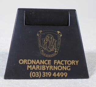 Bendigo Historical Society Inc.
Ephemera - Australian Defence Industries (ADI) desk accessory
Australian Defence Industries (ADI) small triangular plastic desk accessory for desk use, could hold business cards, paper clips, etc. Main edge has the "ADI factory logo and Ordinance Factory Maribyrnong (03) 319 4499" printed in gold. Body of the accessory can be accessed by sliding base panel. made in .... (eligible)local history, adi history -
 Melbourne Tram Museum
Pamphlet, Yarra Trams, "Did you know - No. 5", c2013
Pamphlet - Single DL special size sheet, printed both sides in full colour titled cut for a hanging on a tram handrail, titled "Did You know - No. 5", with an image of a rhino on a skateboard on the front and details that a full tram can weigh as much as 50 tonnes. c2013 - has the Yarra Trams 4 logo.trams, tramways, yarra trams, rhinos, advertisements, safety -
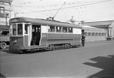 Melbourne Tram Museum
Negative, Wal Jack, 1/09/1941 12:00:00 AM
Black and white negative, by Wal Jack, of S160 at the corner of Lygon and Holden St Brunswick. The conductor is attending to the pole while another person can be seen in the front cab. The tram has the destination of Lygon St and a headlight mask. Photo dated 1-9-1941 in the Wal Jack album along with details of the location.trams, tramways, lygon st, world war 2, holden st, s class, conductors, tram 160 -
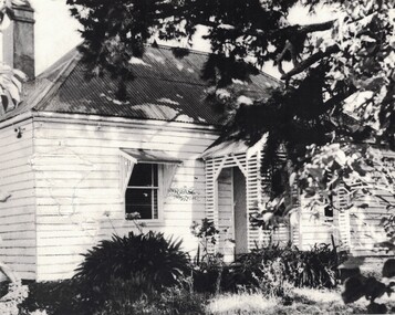 Linton and District Historical Society Inc
Photograph, 'Glenree' : home of the Rankin family
This house, understood to have been built around 1858/59, and demolished around 1990, was situated along what is now known as the Linton-Naringhil Road. It was the home of the Rankin family - John and Catherine Rankin, and later their son Ewen and his wife Anna Rankin. The last member of the Rankin family to live there (until 1974) was Marjorie Jackson, a granddaughter of John and Catherine. The original roof is thought to have been made of wooden shingles.Black and white photograph showing a weatherboard house which has a corrugated iron roof, two front windows and a small front porch. The windows have sunshades supported by timber brackets. A chimney can be seen above the rooftop at the rear of the house. The view of the house is partially obscured by branches of a tree. Date of the photograph is not known.glenree', rankin family, john rankin, ewen rankin, houses -
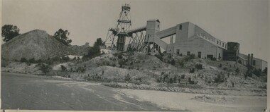 Bendigo Historical Society Inc.
Photograph - CENTRAL NELL GWYNNE MINE
Black and white photograph of Central Nell Gwynne Mine on boundary of Ironbark. This was one of three gold mines marked for assistance to commence the mining revival. This steel poppet head previously stood over the Lightning Hill Mine and firstly over the Virginia Mine. Bendigonians can access the site from Coath Street. Inscriptions: On back - 'MNG 53', 'Nell Gwynne' in lead pencil, 'Central Nell Gwynne' in black ink', 'Royal Historical society of Victoria, Bendigo Branch' circular blue stamp. History of object: previous Acc. No. MNG 53central nell gwynne gold mine, gold mining -
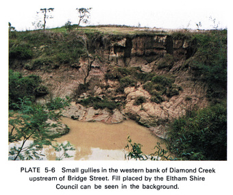 Eltham District Historical Society Inc
Work on paper (Sub-Item) - Photograph, Small gullies in the western bank of Diamond Creek upstream of Bridge Street, Eltham
Colour photograph of a muddy creek (probably after a downpour) on the western bank of Diamond Creek upstream of Bridge Street, Eltham. Fill placed by the Eltham Shire Council can be seen in the backgroundeltham, diamond creek, bridge street, gullies, fill -
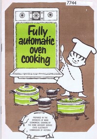 Greensborough Historical Society
Booklet - Recipe Book, State Electricity Commission of Victoria, Fully automatic oven cooking; prepared by the Home Service Section of the State Electricity Commission of Victoria, 1960s
Fully automatic oven cooking: prepared by the Home Service Section of the State Electricity Commission of Victoria. Includes a variety of recipes that can be cooked together using the automatic function on the oven.1960s.Part of a collection of recipe books from Laurence N. Lewis12p. Typed and photocopied text, colour cover.non-fictioncookbooks, recipe books, electric ovens -
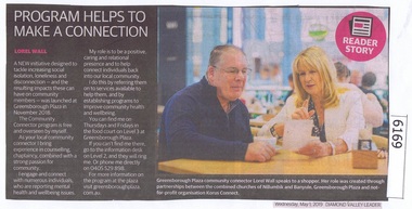 Greensborough Historical Society
Newspaper Clipping, Diamond valley Leader, Program Helps to make a Connection, 01/05/2019
A new initiative designed to tackle increasing social isolation, loneliness and disconnection - and the resulting impacts these can have on community members - was launched at Greensborough Plaza in November 2018 as the Community Connector Program.News article 1 page, black text.social isolation, greensborough plaza, community connector program -
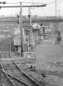 Greensborough Historical Society
Photograph - Digital Image, Upgrades to Greensborough Station 1970, 1970_
Photograph of construction of the new station at Greensborough. The existing track can be seen plus construction of a second track, making the station an island platform. The new station was opened on 03/04/1970.Digital copy of black and white photograph. trains, greensborough railway station -
 Kiewa Valley Historical Society
Drawing Knife
Very old. A drawknife is used to remove large slices of wood for flat faceted work, to debark trees, or to create roughly rounded edges. Can be used to shape the curve of a cricket bat. Used by woodworkers in the Kiewa Valley.Steel frame with wooden handles at each end and a sharp steel blade attached in the middle.Ref. Page 83 Tools for all Trades Catalogue.The drawknife / drawing knife,/ draw shave, / shaving knife is a traditional woodworking hand tool used to shape wood by removing shavings. The blade is much longer (along the cutting edge) than it is deep. It is pulled towards the user. woodworking tool, drawing knife, hand tool -
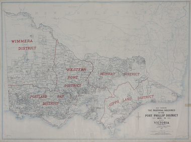 Federation University Historical Collection
Plan, Map Showing the Pastoral Holdings of the Port Phillip District 1835-1851 Now Victoria, 1932, 1932
Another name for Pastoral Holdings is squatting runs. Information on Alfred Stephen Kenyon of the Historical Society of Victoria can be found at http://adb.anu.edu.au/biography/kenyon-alfred-stephen-6936/text12035 Map of Victoria showing the boundaries of the Port Phillip District (Victoria) pastoral boundaries. pastoral holdings, squatters, squatting, victoria, land, crown lands, a.s. kenyon, alfred stephen kenyon -
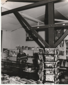 Port Melbourne Historical & Preservation Society
Photograph - Ted Rohan at 'Thirst Aid' kiosk, Station Pier, Port Melbourne, Lloyd Holmes, 1991
Photographed by volunteer Lloyd Holmes, who did copying as well as originals for the Vintage Port Worth Preserving oral history project 1989-1991. Used in 'They Can Carry Me Out'Black and white photograph of Ted Rohan behind souvenir counter of 'Thirst Aid' (western) kiosk, Station Pier, 1991On rear: 'Ted Rohan, "Thirst-Aid" (western) kiosk, Station Pier, 1991. Note pennants, kept in stock since the days of immigration and sea travel at request of ships' crews. Photo LLoyd Holmes (duplicate copy of Library's VP photo)'business and traders - kiosk, piers and wharves - station pier, lloyd holmes, edward j (ted) rohan, thirst-aid kiosk -
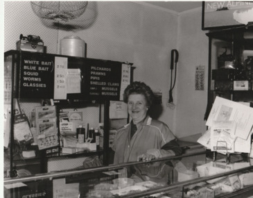 Port Melbourne Historical & Preservation Society
Photograph - Betty Rohan at 'Thirst Aid' kiosk, Station Pier, Port Melbourne, Lloyd Holmes, 1991
Photographed by volunteer Lloyd Holmes, who did copying as well as originals for the Vintage Port Worth Preserving oral history project 1989-1991. Used in 'They Can Carry Me Out'Black and white photograph of Betty Rohan behind the 'fishing' counter of 'Thirst Aid' (western) Kiosk, Station Pier, 1991On back:'Betty Rohan 1991 - 25 years at Station Pier Western Kiosk (fishing tackle and baits added to sales stock at request of the many who fish from the per) Duplicate copy of Library's VP photo'piers and wharves - station pier, business and traders - kiosk, lloyd holmes, betty rohan, thirst-aid kiosk -
 Port Melbourne Historical & Preservation Society
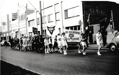
Photograph - Port Melbourne Youth Centre, YMCA & Melbourne City Mission in procession down Bay Street, Reverend Donald LANGFORD, 1967
Groups from Port Melbourne Youth Centre, the YMCA and Melbourne City Mission in a procession down Bay Street, Port Melbourne. The Flower Hotel & Graham Engineering can be seen in the background.B & W photograph of groups from Port Melbourne Youth Centre, YMCA & the Melbourne City Mission.built environment - commercial, business and traders - hotels, business and traders - engineering, graham engineering, flower hotel, melbourne city mission, ymca, port melbourne youth centre -
 Port Melbourne Historical & Preservation Society
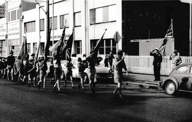
Photograph - Port Melbourne Scouts & Cubs in Bay Street Procession, Reverend Donald LANGFORD, 1967
Group from the Port Melbourne Scout & cub packs salute RAN officer & Scout leader in a procession down Bay Street, Port Melbourne. Graham Engineering can be seen in the background.B & W photograph of group of Port Melbourne Scouts & Cubs in Bay Street parade.1967built environment - commercial, business and traders - engineering, graham engineering, port melbourne scouts, cubs, armed services - navy -
 Stawell Historical Society Inc
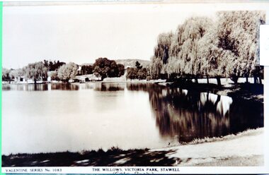
Photograph - View of Cato Lake, Black & White photo of Valentine Series No 1083 Willows Victoria/Cato Lake
View of Victoria/Cato Lake showing just a short section of the walking track and willows around the lake. Houses can be seen in the distance. The lake is very still as the trees are reflected in the water.Black & White photo of Valentine Series No 1083 Victoria/Cato lake. The photo is of a post card of Victoria/Cato Lake. Willow trees line the right side of the photograph. Valentine Series No 1083. The willows Victoria Park, Stawell. stawell -
 Torquay and District Historical Society
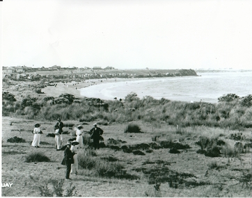
Photograph (copy), Torquay Front Beach circa early 1900s
Photo shows beach front with figures dressed in 'beach wear ' of the time in foreground. A line of bathing boxes in middle ground can be seen. Early Torquay houses along esplanade in background.Black and white photo (copy) of Torquay front beach in early 1900s. -
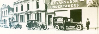 City of Ballarat Libraries
Photograph - Card Box Photographs, H. Evans & Sons Undertakers, Ballarat circa 1931
Henry Evans can be seen wearing the top hat. The building on Main Road was originally the London Chartered Bank built in circa 1875. The original facade is believed to be behind new brickwork.henry evans, undertakers, main road, london chartered bank, ballarat, vehicles, funeral, building, h. evans & son -
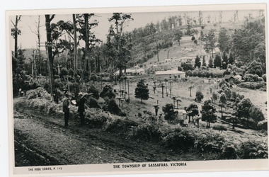 Mt Dandenong & District Historical Society Inc.
Photograph, The Township of Sassafras. Victoria, late 1940s
The township of Sassafras taken late 1940s. The man in the foreground in the trilby, carrying the rucksack is a Rose Series employee. He appears in many of the photos. Sassafras House can be seen in the centre of the picture.Black and white copy of a Rose Series postcard P. 145 showing two men stnding at the side of the road . Behind them is the early township of Sassafras.sassafras -
Port Melbourne Historical & Preservation Society
Audio - Oral History, Lily Goss and Tom Lahiff, Seon Films, May 1991
Interview used in contribution to the book "They can Carry me Out" (Original interview carried out by Seon Films as part of an episode about Port Melbourne for the ABC 4 Corners program)Lily GOSS and Tom LAHIFF recalling their lives in Port Melbourne, football, etcDuration side 01:31:14families, domestic life, social activities, sport - australian rules football, lilian 'lil' goss nee johnson, tommy lahiff -
Port Melbourne Historical & Preservation Society
Audio - Oral History, Lettie Walsh Bradley and Margaret Walsh, Pat Grainger, May 1991
Interview used in contribution to the book "They can Carry me Out" (Original interview carried out by Seon Films as part of an episode about Port Melbourne for the ABC 4 Corners program)Lettie Walsh Bradley and Margaret Walsh recalling their lives in Port MelbourneDuration side 00:58:36families, domestic life, social activities, bradley walsh, lettie walsh, margaret walsh