Showing 10723 items
matching sites
-
 Stawell Historical Society Inc
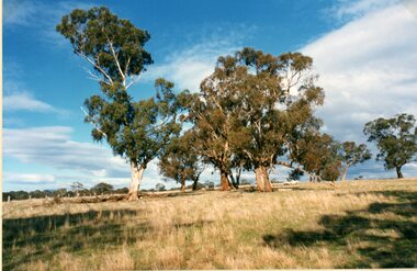
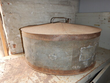
Photograph, Concongella Home Station Site 1994 -- 4 photos -- Coloured
Four photographs of Concongella - Home Station Site 1994stawell -
 Stawell Historical Society Inc
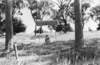
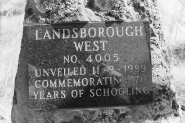
Photograph, Landsborough West State School Number 4005 Plaque -- Old Site
School Site State School No 4005 / Landsborough Weststawell education -
 Stawell Historical Society Inc
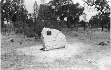
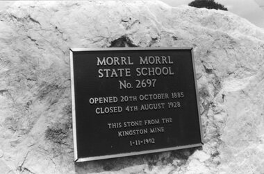
Photograph, Morrl Morrl State School Number 2697 Plaque -- Old Site
School Site State School No 2697 / Morrl Morrlstawell education -
 Stawell Historical Society Inc
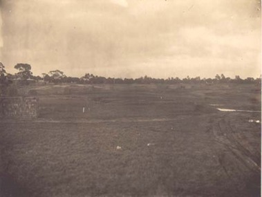
Photograph, North Western Woollen Mills -- Preparing the Site
North Western Woollen Mills - Framed - Preparing the Sitestawell industry -
 Clunes Museum
Functional object - LANTERN
LANTERN USED ON WORK SITE - WARNING POSSIBBLE HAZARD.RED PAINTED LANTERN. FORMERLY OWNED BY PMG.([DEPARTMENT OF POST MASTER GENERAL) METAL CASE HOUSING, REMOVABLE FUEL BOWL RED LAMPSHADE, HANDLE TO HANG LANTERN ON LOW POST, HINGED LID.P.M.G.local history, lighting, kerosene, oil, lighting -
 Parks Victoria - Days Mill and Farm
Domestic object - Food cover
Was used on-site to protect fresh food from flies. OVAL MEAT COVER WITH tin mesh sides, solid tin top with HANDLE at very top. It has been prepared by patching and soldering.food preparation, repairs -
 City of Ballarat Libraries
Postcard - Card Box Photographs, Ballarat Post Office circa 1864
This was the 3rd Post Office on the Lydiard Street North Site.ballarat post office, lydiard street north, building, commerical, public -
 Stawell Historical Society Inc
Photograph, Landsborough West State School Number 4005 Plaque -- Old Site
School Site State School No 4005 / Landsborough Weststawell education -
 Stawell Historical Society Inc
Photograph, Morrl Morrl State School Number 2697 Plaque -- Old Site
School Site State School No 2697 / Morrl Morrlstawell education -
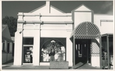 Kilmore Historical Society
Photograph, 13 Sydney Street
Was the site of J. Quinn Bakery and Breakells Bakery and shop20cm x 12.5 black and white photograph of the shop at 13 Sydney Street which at the time of the photograph was J.R. Mens Wear. Light coloured recently renovated building, some of the older trim remains and restored, corrugated steel awning which leads down the arcade, concrete planter box out the front of the shop. Was the location of J. Quinn Bakery and Breakells Bakery and shop. 2 picture available in the item offering slightly different angles.Written on the back: Photo 1: 1024 Photo 2: 1025baker, bakery, bakers and bakeries, shopfront, mens fashion -
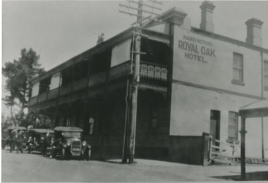 Kilmore Historical Society
Photograph, 29-31 Sydney Street, 1920's?
The site is still the Royal Oak Hotel currently (2020)30cm x 20cm black and white photograph of Harringtons Royal Oak Hotel situated at 29-31 Sydney Street. The building is light coloured and double story. There is a balcony on the top floor has a balcony that provide cover for the ground floor. There is ornate metalwork for the handrails of the balcony. There are three parked car out the front of the hotel where a group of men are sitting.hotels, pubs, inns -
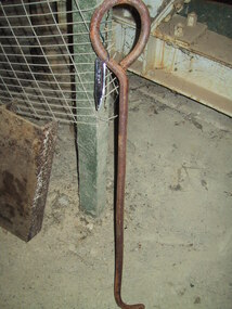 Parks Victoria - Maldon State Battery
Lever
Located on-site behind the battery. It's use is unknown.Long rusty iron rod with round handle on one end, 90 degree angle on other. -
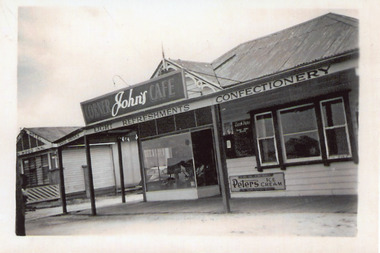 Lakes Entrance Historical Society
Photograph, 1950c
This site became Bamboo Cafe, late the Bamboo MotelBlack and white photograph of Johns Corner Cafe on the corner of Esplanade and Carstairs Street. Corner of Robin Hood Inn in background. Lakes Entrance Victoriarestaurant, motels -
 Lakes Entrance Historical Society
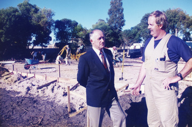
Photograph - Childcare Centre, Lakes Post Newspaper, 1997
Built on former site of Primary School pine plantation.Colour photograph of the laying of the foundation slab for the Lakes Entrance Child Care Centre, at 45 Coates Road. Councillor Ray Hack and builder Phillip Baade discussing progress. Lakes Entrance Victoriapublic utilities, buildings -
 Lakes Entrance Historical Society
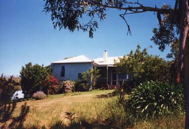
Photograph - Bunga Haven, 1999
Built on site of Northrope's original bark residence (1890c).Colour photograph of a property known as Bunga Haven at 127 Lake Bunga Road. A timber dwelling with corrugated iron roof overlooking Lake Bunga and Bass Strait. Set in rustic garden and native bushland. Dropped log boundary fence and brush gate. Lakes Entrance Victoriaaccommodation, tourism -
 Greensborough Historical Society
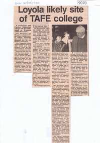
Article - Newspaper Clipping, Diamond Valley News, Loyola likely site of TAFE college 1985, 20/08/1985
Article about likely site of a TAFE college at LoyolaText and black and white imagegreensborough, schools, loyola college, diamond valley tafe -
 University of Melbourne, Burnley Campus Archives
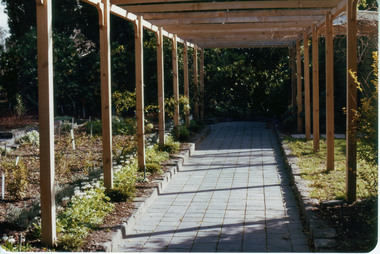
Photograph - Colour print, Sunken Garden, c. 1983
Work commenced 1981 on the site of the former Principal's Residence Colour photographs. (1) Newly constructed pergola with new planting around Sunken Garden on the left. "Sunken Garden Pergola 1983-4." (2) A Gardener planting the Sunken Garden." (3)" Sunken Garden." pergola, planting, sunken garden -
 University of Melbourne, Burnley Campus Archives
Photograph - Colour print, Burnley Library, Unknown
Library built on site of part of former Lagoon Paddock. Colour photograph. One of the original Elm trees with new Library behind.elm tree, library, new library -
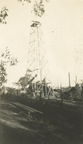 Lakes Entrance Historical Society
Photograph, No 8 Oil Well, off Myers Street Lakes Entrance Victoria, 1/09/1930 12:00:00 AM
Keith Scarce was a rig hand on this site for short timeSepia toned photograph of oil derrick SA Oil Co No 8 Well situated off Myers Street at rear of present Secondary College Lakes Entrance Victoriaoil and gas industry, engineering, social history -
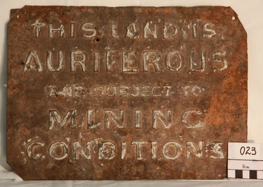 Myrtleford and District Historical Society
Gold Mining Sign
This sign was required to be displayed in the vicinity of gold mining sites. Myrtleford district was known to have had 100 sites within a ten mile radius of the town; the sign was recovered by Charlie McFadyen, a local prospector and fossicker, of some 60 yearsThe sign relates to local gold mining activity, a key source of wealth and employment from 1854 to the late 19th century. Such signs continued to be in use during the period between World War 1 and 2,including the period of the Great Depression.Tin rectangular mining sign embossed with a warningInscription: "THIS LAND IS AURIFEROUS AND SUBJECT TO MINING CONDITIONS"auriferous mining -
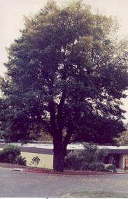
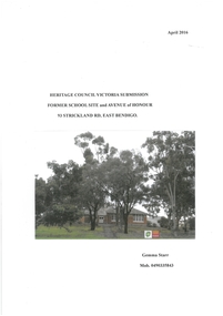 Bendigo Historical Society Inc.
Article - Article for Bendigo East State School Heritage Council Submission
Gemma Starr Collection: Re: Heritage Council Victoria Submission Former School Site and Avenue of Honour 93 Strickland Road, East Bendigo. Contents: Statement of Cultural Heritage Significance, Overview of Victorian State School's WW1 Efforts, Early History of Bendigo East School and Avenue of Honour, Bendigo East School and Avenue of Honour Site Today, Men Commemorated in Bendigo East's Avenue of Honour, Comparison between Eurak Avenue of Honour Site and Bendigo East School and Avenue of Honour Site, School Avenues Planted before Bendigo East's Avenue, School Avenues Planted on the same Dade as Bendigo East's Avenue, Later School Avenues Mentioned in Heritage Victoria's Report, Final Comments, References, Appendices. Includes copies of original correspondence, newspaper articles and interviews with various people. Avenue of Honour planted 1916, Submission for Heritage Protection prepared 2016. Originally 23 trees planted then additional trees planted to make a total of 31 with plaques honouring 31 soldiers from the district. Brief biographies are listed within the submission for each soldier. The school merged with Weeroona College, and the doors closed on East Bendigo State School December 1998. Names associated with Submission: Gilbert Dyett, John Hampson, Keith Emmonson, Samuel C. Brittingham (Senior Architect). Joseph William Fairbanks (Building Contractor), Randall Jones, Stanley Symes. Jack Whitting, Mr. Phillips (Head Master 1916), Mr. Graham Parker (Last Principal), Mr. Donald Campbell (Principal)bendigo east state school, anzac, avenue of honour, heritage submission -
 Sunbury Family History and Heritage Society Inc.
Photograph, c 1930s
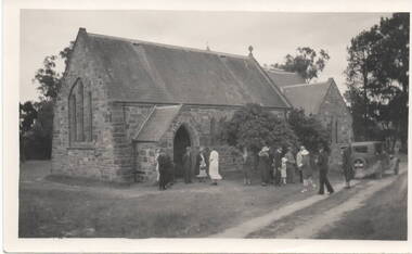
St. Mary's Anglican Church at Bulla originally occupied a site along Oaklands Road, adjacent to 'Woodlands' homestead. It was established in 1859. With there building of the Melbourne Airport at Tullamarine it was found that the church on its existing site was directly under the flight path of the aircraft so the building was demolished stone by stone and rebuilt in the Bulla township adjacent to the Alistair Clark Rose Garden. The original site has not been developed because some early graves are there.St. Mary's Church at Bulla is one of the earliest to be established in the Bulla district. Its mother church, St Pauls Church of England at the original Broadmeadows township was established in 1850 and it still stands and operates on its original site.A black and white photograph with a cream border of a stone church with the congregation members entering the church. A saloon car is parked near the church.st. mary's church of england, bulla., churches. -
 Whitehorse Historical Society Inc.
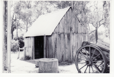
Photograph, Smithy's Shed, 1996
The Blacksmith's shop or 'Smithy' was erected from timbers found in a paddock in the Dandenong Ranges by Mr George Cox which were transported to the Cottage site and re-erected in 1970 on a part of the site where remains of a previous building had been found.Coloured photo of Blacksmith's Shedblacksmith, smithy, schwerkolt cottage -
 Whitehorse Historical Society Inc.
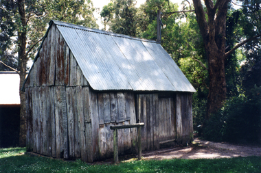
Photograph, Schwerkolt Cottage
The Blacksmith's shop or 'Smithy' was erected from timbers found in a paddock in the Dandenong Ranges by Mr George Cox which were transported to the Cottage site and re-erected in 1970 on a part of the site where remains of a previous building had been found.Black and white photo of Smokehouse and Smithy at Schwerkolt Cottageschwerkolt cottage, smokehouse, smithy, blacksmith forge -
 Whitehorse Historical Society Inc.
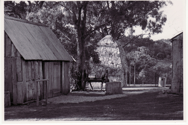
Photograph, Schwerkolt Cottage, 1973
The Blacksmith's shop or 'Smithy' was erected from timbers found in a paddock in the Dandenong Ranges by Mr George Cox which were transported to the Cottage site and re-erected in 1970 on a part of the site where remains of a previous building had been found.Black and white photo of Blacksmith's shop at Schwerkolt Cottageschwerkolt cottage, smithy, blacksmith's -
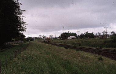 Ballarat Tramway Museum
Slide - Set of 2 - COTMA 2000 Visit to Bungaree, David Verrier, 20-11-2000
Set of two slides taken during the 2000 COTMA Conference visit to the Ballarat Tramway Museum Bungaree station site of Sprinter rail cars 7008 & 7022 on Down Ballarat service at the former Bungaree station site on 20-11-2000Demonstrates rail services through the former Bungaree Rail stationSet of two Kodak colour slides - white plastic mountEach slide has details written on it.ballarat, specials, cotma, btm, bungaree, sprinter rail cars -
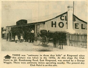 Ringwood and District Historical Society
Photograph - Newspaper Clipping, Early View of Club Hotel, Ringwood East
The newspaper clipping caption is incorrect. The Club Hotel featured in the article was located on the north side of Mount Dandenong Road. It was destroyed by fire in 1890 prior to re-opening later on the south side where it operated until sale and demolition in 2020 to make way for a retirement village. (See PDF attached - "SS0067 Vic Collections 3754b - Club Hotel Fire 1890").Early View of Club Hotel, Ringwood East. Weatherboard with iron roof. Single chimney on one end. Picket fence on RHS. Two horse-drawn vehicles standing out front including three adults and two children. Source/date of newspaper unknown. Later newspaper item also attached reporting hotel being destroyed by fire in 1890.Caption: There was 'antimony in them thar hills' at Ringwood when this picture was taken in the 1890s. At that time the Club Hotel in Mt Dandenong Road, East Ringwood was owned by a George Wiggin. There were antimony mines operating nearby. The present-day Club Hotel is on this site. -
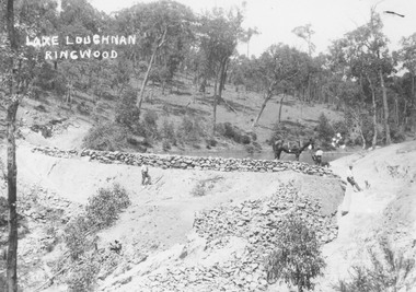 Ringwood and District Historical Society
Photograph, Building the recreational man-made lake on the north side of Loughnans Hill: "Lake Loughnan". (Undated)
Printed on photo "Lake Loughnan Ringwood"Typed below photograph, "Building the recreational man-made lake on the north side of Loughnans Hill. It was the local swimming hole in Werac Drive gully beyond Kubis Drive. Now site of a new housing estate." Written on Photo "Lake Loughnan Ringwood" -
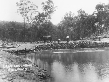 Ringwood and District Historical Society
Photograph, Building the recreational man-made lake on the north side of Loughnans Hill
Typed below photograph, "Building the recreational man-made lake on the north side of Loughnans Hill. It was the local swimming hole in Werac Drive gully beyond Kubis Drive. Now site of a new housing estate". Written on photo: Lake Loughnan Ringwood -
 Ringwood and District Historical Society
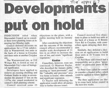
Newspaper, Scrapbook Clipping, Library Collection, Ringwood, Victoria
Newspaper Clipping from "The Post", 10-3-1998. 79. Dvelopments put on holdMaroondah Coincil sat to consider three town planning issues at its meeting last Monday night. Council deferred decisions on applications for a 17 lot subdivision in Warranwood; two units at the back of a house in Croydon and three units at another Croydon site.