Showing 2561 items
matching aerial
-
 Glenelg Shire Council Cultural Collection
Photograph - Photograph - aerial view of Portland harbour, 1960
Port of Portland AuthorityFront: Harbour: Aerial view south. July '60 - typed, bottom.port of portland archives, aerial photography, portland harbour -
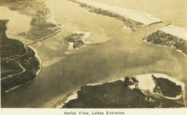 Lakes Entrance Historical Society
Postcard - Aerial view Lakes Entrance, H D Bulmer, 1922 c
Image clearly shows new alignment of Princes Highway around Jemmys Point and part of the original high road to the first bend above North Arm BridgeBlack and white postcard aerial view of the western area of the town, Bullock Island and Snake Island and waterways Lakes Entrance VictoriaAerial View Lakes Entrancewaterways, islands, township -
Glenelg Shire Council Cultural Collection
Photograph - Photograph - aerial view of the train track between Heywood and Rennick, 03/05/1952
Black and white aerial photographs (aerial survey record print) of the railway line between Heywood and Rennick (S.A. border) Taken for Victorian Railways, May 1952. Some photos have annotations later added to the front of the image in penVictorian Railways aerial survey record print of the railway line between Heywood and Rennick (S.A. border) Black and white, white vertical strip on imageFront: Annotations in red ink added at a later date Back: 'Heywood - Rennick 21577 - 19840 279m 41c ' - all black ink. White sticker, black print 'Rennick' Purple VR aerial survey stamp. '3 May 1952' - black stampvictorian railways, travel, train, transport -
Glenelg Shire Council Cultural Collection
Photograph - Photograph - aerial view of Portland, 1960
Port of Portland Authority ArchivesBack: Aerial View South - July '60 -Top left, pencilport of portland archives, aerial photography, portland harbour -
 St Kilda Historical Society
Photograph - Photo map, 13/01/1968
One of a series of photo-maps produced for the Department of Crown Lands and Survey (1857-1983). For correlation with a current map, and access to other historical photo maps of Victoria, see the Historic Photo-Maps Index published by the Department of Environment, Land, Water and Planning at https://services.land.vic.gov.au/DELWPmaps/historical-photomaps/Black and white aerial photograph2138 State Aerial Survey Melbourne 1968 Proj. Run 26 13.1.68 5100 ASL 203st kilda west, albert park, fawkner park, south yarra, prahran, windsor, 1968 -
 St Kilda Historical Society
Photograph - Photo map, 11/01/1968
One of a series of photo-maps produced for the Department of Crown Lands and Survey (1857-1983). For correlation with a current map, and access to other historical photo maps of Victoria, see the Historic Photo-Maps Index published by the Department of Environment, Land, Water and Planning at https://services.land.vic.gov.au/DELWPmaps/historical-photomaps/Black and white aerial photographVic 2132 State Aerial Survey Melbourne 1968 Proj. Run 27E 11.1.68 5100 ASLst kilda, st kilda west, st kilda pier, catani gardens, st kilda beach, albert park, 1968 -
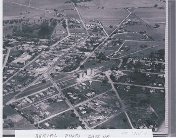 Rutherglen Historical Society
Image, c 1958
Black and white aerial photograph of Rutherglen, believed to be in the late 1950sCaption pasted to bottom of photo: "Aerial Photo Date U.K. Late 1950s ?"rutherglen, aerial photographs -
 St Kilda Historical Society
Photograph - Aerial, St Kilda
showing Luna Park, the Palace Theatre, the Palais and St Moritzblack and white photograph, unmounted original, good conditionNeg 27 -
 St Kilda Historical Society
Photograph - Photo map, 11/01/1968
One of a series of photo-maps produced for the Department of Crown Lands and Survey (1857-1983). For correlation with a current map, and access to other historical photo maps of Victoria, see the Historic Photo-Maps Index published by the Department of Environment, Land, Water and Planning at https://services.land.vic.gov.au/DELWPmaps/historical-photomaps/Black and white aerial photographVic 2132 State Aerial Survey Melbourne 1968 Proj Run 27E 11.1.68 5100 ASL 65caulfield north, caulfield park, armadale, malvern, 1968 -
 St Kilda Historical Society
Photograph - Photo map, 11/01/1968
One of a series of photo-maps produced for the Department of Crown Lands and Survey (1857-1983). For correlation with a current map, and access to other historical photo maps of Victoria, see the Historic Photo-Maps Index published by the Department of Environment, Land, Water and Planning at https://services.land.vic.gov.au/DELWPmaps/historical-photomaps/Black and white aerial photographVic 2132 State Aerial Survey Melbourne 1968 Proj Run 27E 11.1.68 5100 ASL 67st kilda east, st kilda cemetery, caulfield north, alma park, balaclava, armadale, 1968 -
 St Kilda Historical Society
Photograph - Photo map, 11/01/1968
One of a series of photo-maps produced for the Department of Crown Lands and Survey (1857-1983). For correlation with a current map, and access to other historical photo maps of Victoria, see the Historic Photo-Maps Index published by the Department of Environment, Land, Water and Planning at https://services.land.vic.gov.au/DELWPmaps/historical-photomaps/Black and white aerial photographVic 2132 State Aerial Survey Melbourne 1968 Proj. Run 27E 11.1.68 5100 ASL 69st kilda, albert park, st kilda east, st kilda beach, alma park, windsor, prahran, 1968 -
 St Kilda Historical Society
Photograph - Photo map, 11/01/1968
One of a series of photo-maps produced for the Department of Crown Lands and Survey (1857-1983). For correlation with a current map, and access to other historical photo maps of Victoria, see the Historic Photo-Maps Index published by the Department of Environment, Land, Water and Planning at https://services.land.vic.gov.au/DELWPmaps/historical-photomaps/Black and white aerial photographVic 2132 State Aerial Survey Melbourne 1968 Proj. Run 28E 11.1.68 5100 ASL 81st kilda, balaclava, st kilda east, ripponlea, elwood, elsternwick, caulfield, st kilda botanical gardens, 1968 -
 St Kilda Historical Society
Photograph - Photo map, 11/01/1968
One of a series of photo-maps produced for the Department of Crown Lands and Survey (1857-1983). For correlation with a current map, and access to other historical photo maps of Victoria, see the Historic Photo-Maps Index published by the Department of Environment, Land, Water and Planning at https://services.land.vic.gov.au/DELWPmaps/historical-photomaps/Black and white aerial photographVic 2132 State Aerial Survey Melbourne 1968 Proj. Run 29E 11.1.68 5100 ASL 194elwood, elwood beach, elwood park, elsternwick park, ripponlea, elwood canal, balaclava, st kilda, 1968 -
 St Kilda Historical Society
Photograph - Photo map, 11/01/1968
One of a series of photo-maps produced for the Department of Crown Lands and Survey (1857-1983). For correlation with a current map, and access to other historical photo maps of Victoria, see the Historic Photo-Maps Index published by the Department of Environment, Land, Water and Planning at https://services.land.vic.gov.au/DELWPmaps/historical-photomaps/Black and white aerial photographVic 2132 State Aerial Survey Melbourne 1968 Proj. Run 29E 11.1.68 5100 ASL 196elwood, elwood park, elwood canal, elwood beach, st kilda marina, mc moran reserve, point ormond, 1968 -
Glenelg Shire Council Cultural Collection
Postcard - Postcard - Portland Harbour, c. 1970
Coloured photo postcard, serrated edge. Aerial view of Portland and harbour, 1970sBack: Maker details. 'Portland Vic, Aerial view of Portland Harbour'postcard, aerial view of portland harbour -
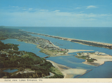 Lakes Entrance Historical Society
Postcard - Aerial view Lakes Entrance, Murray View Gympie Qld, 1970 c
Also a second postcard lookin west showing township, North Arm and Kalimna Heights 05213.1 10 x 15 cmBlack and white postcards showing aerial views of township, North Arm and Cunninghame Arm, Bullock Island and part of Kalimna Heights and Jemmys Point Lakes Entrance VictoriaAerial view of Lakes Entrance Victownship, waterways, islands -
Glenelg Shire Council Cultural Collection
Photograph, c. 1967
Port of Portland Authority archives On 19 November 1960, the Portland Harbour Trust was officially opened by His Excellency, The Governor of Victoria, Sir Dallas Brooks, in front of thousands of onlookers. It was one of the largest concentration of Premiers, Statesmen, industrial and civic leaders ever to attend an event outside of an Australian capital city. Today, Port of Portland is a busy modern port, handling in excess of $2 billion in trade. One of Victoria’s four major shipping ports, it handles bulk cargoes such as plantation woodchips and logs, grain, aluminium products, mineral sands, fertiliser, livestock and wind tower components.This forms part of the archives of the Port of Portland which were donated to the Glenelg Shire Cultural Collection by the Port of Portland. The collection documents the growth and significance of the Port of Portland.Back: Aerial view of section of Port and its surroundsport of portland, henty park, portland botanic gardens -
 Port Fairy Historical Society Museum and Archives
Photograph
Aerial view of Port Fairy WestColoured aerial photographsand hill cemetery, water tower, west -
 University of Melbourne, Burnley Campus Archives
Photograph - Black and white print, College and Grounds, c. 1990
Aerial photograph of College and grounds. Could be late 1980'saerial, burnley college -
Glenelg Shire Council Cultural Collection
Photograph - Photograph - land reclamation, 1959
Port of Portland Authority ArchivesFront: Canal and Reclamation. Aerial view west November 1959 - typed.port of portland archives, land reclamation, canal, botanic gardens -
Glenelg Shire Council Cultural Collection
Postcard - Postcard - Nelson, Victoria, n.d
Coloured photo postcard, aerial view of Nelson, Victoria, showing the bridge, township and river mouth. Rose Series De Luxe colorview NO 1213Back: Maker details. 'Aerial view of Nelson Victoria'postcard, nelson -
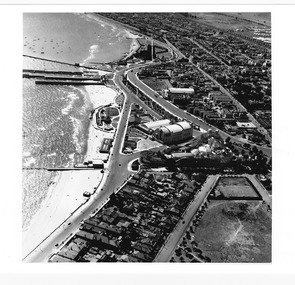
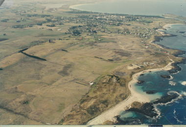
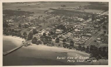
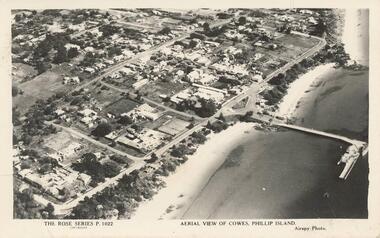 Phillip Island and District Historical Society Inc.
Photograph - Post Card, Unknown
Donated by Stan McFee from the Keith McIlwraith Collection.Black & White postcard showing an aerial view of Cowes Town Centre, beach and pier."The Rose Series P. 1022" "Aerial view of Cowes, Phillip Island." "Airspy Photo".cowes phillip island, cowes foreshore and pier, phillip island, stan mcfee, keith mcilwraith collection -
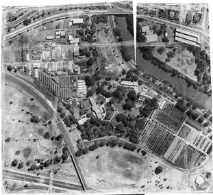
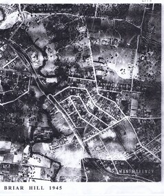 Greensborough Historical Society
Aerial Photograph, Briar Hill 1945, 1945_
Aerial survey photograph of Briar Hill area produced in 19452 photocopies of aerial surveysbriar hill -
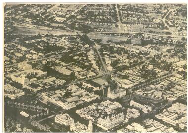 Bendigo Historical Society Inc.
Map - BENDIGO MAP AERIAL VIEW, 1890s
Map of Bendigo. Aerial View of Bendigo. This aerial photograph was taken specially to mark the pccasion of the United Country party conference of 1936. Issued with the complements of 'The Argus' April 1936.photograph, aerial, bendigo -
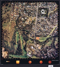
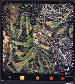
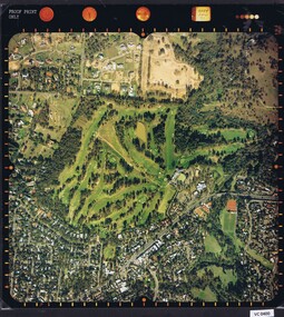 Heidelberg Golf Club
Photograph - Aerial Photograph, Heidelberg Golf Course 2000, 01/05/1980
Aerial photograph of Heidelberg Golf Club course in 1980, showing the course layout and surrounding land use.Aerial photograph, colour.Printed on edge of photo: "Colour proof", "LandSur756"aerial photographs, heidelberg golf club, lower plenty -
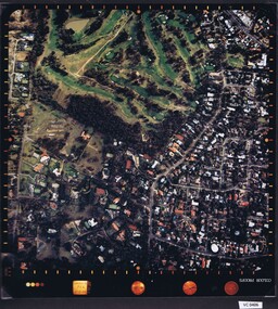 Heidelberg Golf Club
Photograph - Aerial Photograph, Heidelberg Golf Course 2000, 01/05/1980
Aerial photograph of Heidelberg Golf Club course in 1980, showing layout of course and surrounding land use.Aerial photograph, colour.Printed on edge of photo: "Colour proof", "LandSur756"aerial photographs, heidelberg golf club, lower plenty -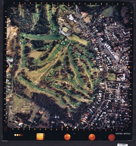
 Phillip Island and District Historical Society Inc.
Photograph - Post Card, Early 1900's
Photograph donated by Les JonesBlack & White postcard of an aerial view of Cowes. Jetty on the left - tree lined Thompson Avenue - Isle of Wight Hotel on the Esplanade left of Thompson Avenue and Bayview Guesthouse on the right on the Esplanade. Township and farmland."Aerial View of Cowes, Phillip Island. No. 147"aerial view of cowes phillip island, cowes township, part cowes township - cowes beach and jetty, phillip island, les jones