Showing 1601 items
matching archaeology
-
 Working Heritage Crown Land Collection
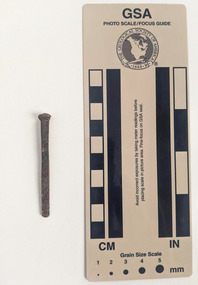
Functional object - Nail, Nail - medium rose head with star
Corroded nail with rectangular shaft narrowing to a blunt tip. The head is slightly irregular. Horizontal incised lines on shaft below head.archaeology, historic building, former royal mint -
 Working Heritage Crown Land Collection
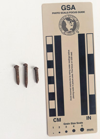
Functional object - Nail, Nail - small with rounded irregular head
Three corroded nails with rounded shaft consistent in diameter to a pointed tip.archaeology, historic building, former royal mint -
 Working Heritage Crown Land Collection
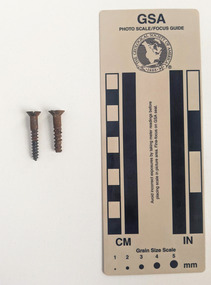
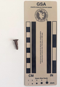
Functional object - Nail, Nail - medium screw
Two corroded screws with circular narrowing to a pointed tip. Incised screw grooves extending down the body of the shaft. Incised notch extending across the nail head.archaeology, historic building, former royal mint -
 Working Heritage Crown Land Collection
Functional object - Nail, Nail - small screw
Three corroded screws with circular narrowing to a pointed tip. Incised screw grooves extending down the body of the shaft. Incised notch extending across the nail head.archaeology, historic building, former royal mint -
 Working Heritage Crown Land Collection
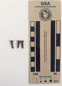
Functional object - Nail, Nail - small screw
Corroded screw with circular narrowing to a pointed tip. Incised screw grooves extending down the body of the shaft. Incised notch extending across the nail head.archaeology, historic building, former royal mint -
 Working Heritage Crown Land Collection
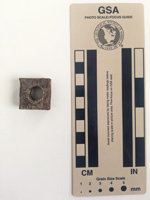
Functional object - Nail, Nut
Square-shaped nut with a circular perforation measuring 1.3cm with interior grooves.archaeology, historic building, former royal mint -
 Working Heritage Crown Land Collection
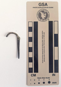
Functional object - Nail, Nail - medium with hooked head
Corroded nail with rectangular shaft that narrows to a blunt tip. The head is hooked and appears to have been a secondary manufacturing process, attached to a machine cut shaft.archaeology, historic building, former royal mint -
 Working Heritage Crown Land Collection
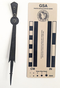
Functional object - Nail, Clock hand
Alloy clock hand with a circular plate and pointed tip. archaeology, historic building, former royal mint -
 Ballarat Tramway Museum
Document, City of Ballarat, "Statement regarding tram tracks at Bridge Mall", 21-11-2023
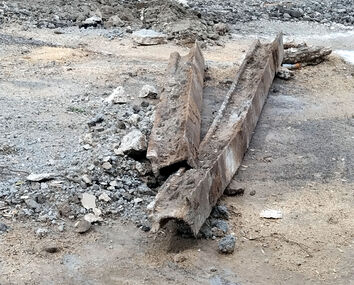
The two items concern the work being undertaken at the time by the City of Ballarat to reconstruct Bridge St Mall. The City of Ballarat notes the archaeological significance of the works. The photograph shows some of the rail being excavated. Understood that the work is being done in four stages.Demonstrates the work to return road traffic to Bridge St BallaratReport downloaded from the City of Ballarat website - 21-11-2023 and digital image from [email protected] received by email 21-11-2023bridge st, bridge mall, city of ballarat, roadworks -
 Queenscliffe Maritime Museum
Functional object - Anchor from Eliza Ramsden
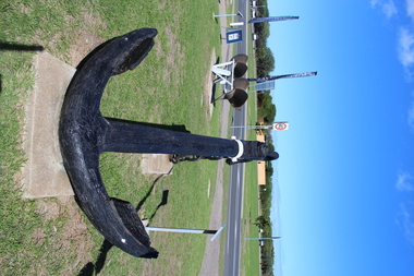
The Eliza Ramsden, with its intact clipper bow, is one of Victoria's most aesthetically spectacular shipwreck sites, and thus has both recreational and educational significance. It is archaeologically significant as relics of cultural significance, including a small ship's bell, have been found on the site.Struck Corsair Rock and later sank in South Channel, Port Philip on 24 July 1875. Now a popular diving site. Large Anchor ex Eliza Rambden which was wrecked on Corsair Rock Point Nepean 24/071875 Made of Cast Ironeliza ramsden, shipwrecks, port phillip, anchors -
 Greensborough Historical Society
Photograph, Jan Macdonald, Viewbank Farm silos - Banyule Road, 1999
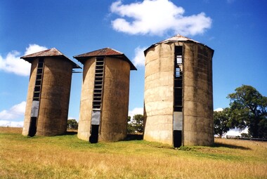
Colour photograph of Viewbank Farm Silos - Banyule Road. Silos were built in the 1930s by Harold Bartram. He used them to store fodder for his 200 milking cows. A brief history of the site is included. These photos taken in 1999 during the Viewbank Homestead archaeological dig.2 colour photographs of Viewbank Farm silosviewbank homestead, viewbank silos, harold bartram, banyule road viewbank, viewbank, archaeological digs -
 Queenscliffe Maritime Museum
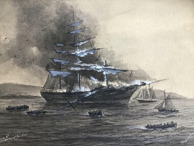
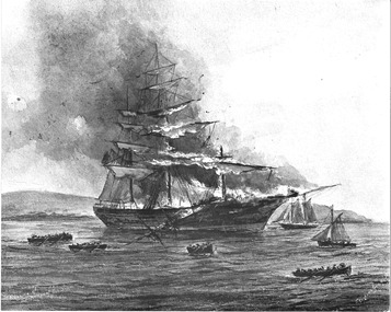
Painting - Painting - watercolour 'Empress of the Sea', Charles Dickson Gregory, 'Burning of the Empress of the Sea'
The Empress of the Sea is historically and archaeologically significant as it was one of Donald Mackay's famous wooden clipper ships ie: representative of a particular design or type. It was also associated with both the Black Ball and White Star Lines of Australian Packets, which carried thousands of immigrants from Britain to Australia.An original watercolour painting of the burning of the sailing ship 'Empress of the Sea' by charles Dickson GregoryFront: Burning of the Empress of the Sea, C. Dickson Gregory. Back: Whatmans watercolour drawing board, 36640, C. Dickson Gregory, 41 Albert Street. Fixed label: 'Destruction of the famous clipper 'Empress of the Sea' at Port Phillip Heads 19th December 1861 Drawing by C. Dickson Gregoryempress of the sea, watercolours -
 Queenscliffe Maritime Museum
Photograph - Photograph of the Painting (water colour) of the 'Empress of the Sea' burning, Charles Dickson Gregory, 'Burning of the Empress of the Sea'
The Empress of the Sea is historically and archaeologically significant as it was one of Donald Mackay's famous wooden clipper ships ie: representative of a particular design or type. It was also associated with both the Black Ball and White Star Lines of Australian Packets, which carried thousands of immigrants from Britain to Australia.Photograph of an original water colour painting of the burning of the sailing ship 'Empress of the Sea' by Charles Dickson GregoryFront: Burning of the Empress of the Sea, C. Dickson Gregory. Back: nilempress of the sea, watercolours -
 Ringwood and District Historical Society
Book, Anita Barker, From the Ashes Children at the Coach & Horses Hotel, 2008
Ringwood Early Beginnings, Ringwood in the 1890's, Childhood and the people at The Coach & Horses Hotel - Thesis submitted as part of the Final Honours Examination in the Archaeology Program La Trobe University 2008 +Additional Keywords: Anita Barker. Hard-bound copy 124 pages with digital addenda CD of Artefact Catalogue & Photograph Catalogue. (CD copied to RDHS Library Master Images - File Ref: 4424 Coach and Horses Hotel Addenda CD) -
 Greensborough Historical Society
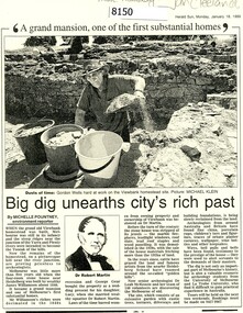
Article - Newspaper Clipping (copy), Michelle Pountney, Big dig unearths city's rich past, 18/01/1999
In 1999, an archaeological dig was undertaken at the Viewbank Homestead site in Viewbank. The house was built c1840 by James Williamson; it was later purchased by George Gear as a wedding gift to his daughter on her marriage to Dr Robert Martin. It became a grand mansion in the late 1800s but by the 1920s, it was stripped bare of materials and demolished in the 1920s. The archaeological dig was and insight into early life in the Viewbank HomesteadCopy of news clipping, black and white text and images.viewbank homestead, banyule road viewbank, viewbank, archaeological digs -
 Greensborough Historical Society
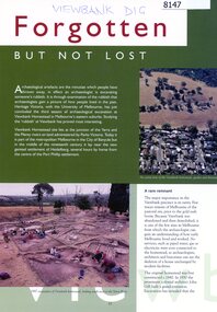
Article - Article, Journal, Forgotten but not lost, 1999
In 1999, an archaeological dig was undertaken at the Viewbank Homestead site in Viewbank. The house was built c1840 by James Williamson; it was later purchased by George Gear as a wedding gift to his daughter on her marriage to Dr Robert Martin. It became a grand mansion in the late 1800s but by the 1920s, it was stripped bare of materials and demolished in the 1920s. The archaeological dig was an insight into early life in the Viewbank HomesteadMagazine clipping, colour text and images.viewbank homestead, banyule road viewbank, viewbank, archaeological digs -
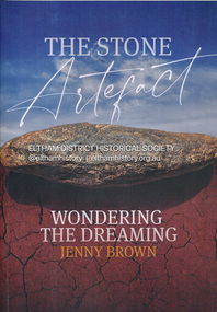 Eltham District Historical Society Inc
Book, Jenny Brown, The stone artefact : wondering the dreaming, 2022
The discovery in a Melbourne park (opposite the Osborne Peninsula, North Warrandyte) of an enigmatic Aboriginal stone tool led writer Jenny Brown on a fascinating journey that connected her with expert anthropologists, archeologists, Indigenous elders and knowledge holders to discover what it was. The stone tool invited many interpretations and spun off just as many amazing stories and experiences. It also afforded Jenny the appropriate canvas to tell of her own time-warping encounters with the extraordinary "otherness" of Aboriginal Australia, and with an especially marvelous character, the late Elder of the Yuin Tribe of southern NSW, Guboo Ted Thomas.193 pages : illustrations (chiefly colour), maps, portraits ; 30 cmindigenous history, aboriginal artefacts, warrandyte, archaeology -
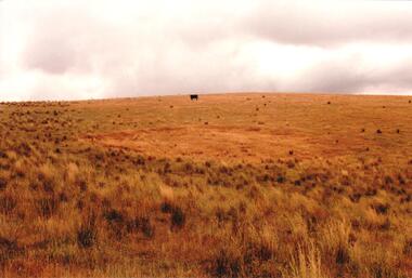 Hume City Civic Collection
Photograph, c late 1990s
The series of 9 photographs were taken to be included in a study of archaeological sites and Aboriginal rings in the Sunbury area. Five earth rings which are thought to be associated with male initiation ceremonies have been identified in Sunbury. Only 3 others have been found in the rest of Victoria. Despite rapid development in the area, those sites are protected heritage sites.A coloured photograph of an Aboriginal Ring which is a proclaimed sacred site on an open grassy hillside. A black cow is standing in the distance.aboriginal culture, aboriginal rings, sacred sites, george evans collection -
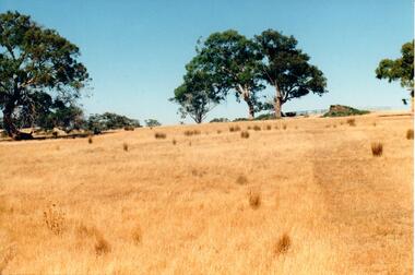 Hume City Civic Collection
Photograph, c late 1990s
The series of 9 photographs were taken to be included in a study of archaeological sites and Aboriginal rings in the Sunbury area. Five earth rings which are thought to be associated with male initiation ceremonies have been identified in Sunbury. Only 3 others have been found in the rest of Victoria. Despite rapid development in the area, those sites are protected heritage sites.A coloured photograph of an open hillside which is a sacred site. Gum trees and grassy tufts are dotted across the hillside.aboriginal culture, aboriginal rings, sacred sites, george evans collection -
 Hume City Civic Collection
Photograph, c late 1990s
The series of 9 photographs were taken to be included in a study of archaeological sites and Aboriginal rings in the Sunbury area. Five earth rings which are thought to be associated with male initiation ceremonies have been identified in Sunbury. Only 3 others have been found in the rest of Victoria. Despite rapid development in the area, those sites are protected heritage sites.A view of the Aboriginal ring and sacred site and its close proximity to a proposed housing estate at Sherwood near Racecourse Road.aboriginal culture, aboriginal rings, sacred sites, george evans collection -
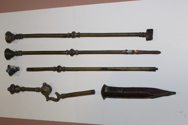 Queenscliffe Maritime Museum
Equipment - Fire implements
The wreck site of the Earl of Charlemont is historically and archaeologically significant for the remains of its cargo and passengers' belongings from an international immigrant ship of the gold rush period, representing the cultural material being bought out to Australia in a typical immigrant ship. It is socially significant for the descendants of the many immigrants who made it ashore safely, and who have erected a memorial cairn to their forbears on Point Flinders.4 brass implements: fire poker, fire shovel handle, shaft and head of unknown implement, piece if fire tongs. 1 copper dumpship wrecks, earl of charlemont, fire implements -
 Unions Ballarat
Journal of Australasian mining history 2006, Australian Mining History Association, 2006
Periodical/journal: "Embracing all aspects of mining history, mining archaeology and heritage." Articles by various contributors includes topics around mining history: Keelbottom Freehold Copper Mines Cornish, Scottish and Australian copper mining Moonta OH&S Emuford Battery Copper mining - Northern Territory Thames Miners Union Blackwater gold mine - New Zealand Burra St Wells Tin Mine Relevant to Australian and New Zealand history, particularly around miners and mining.Paperback. Front cover: crème coloured background; black and white photo; red and black lettering; 200 pages.Front cover: title and publisher.btlc, ballarat trades and labour council, ballarat trades hall, history - mining, moonta mines, blackwater gold mine, mining - copper, keelbottom freehold copper mines, oh&s, emuford battery, thames miners union, burra, st wells tin mine -
 Hume City Civic Collection
Photograph, early 1990's
The scarred tree is located on a hillside in a local reserve. The bark has been removed in the past to make a boat or other large utensil. Melbourne's skyline can be seen faintly in the distance in the middle of the photograph with local suburban development in the middle distance. The set of 20 photographs were taken of a number of archaeological ands sacred sites in the Bulla district. The photographs were included in a study published by the Shire of Bulla in the early 1990's.A scarred tree aboriginal ring sites, george evans collection -
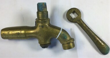 Queenscliffe Maritime Museum
Equipment - Tap, brass
Along with the wrecks of the Light of the Age (1868 - American-built wooden clipper ship) and Sussex (1871 - Blackwall frigate) nearby these vessels represent the three major design classes, and span the evolution of commercial and immigrant sailing ships used by the British in the colonial Australian trade in the last half of the nineteenth century. Taken as a group, it can be seen that the Great Ocean Road area wrecks constitute an extremely rich resource of historical and archaeological information.The Victoria Tower is archaeologically significant as the wreck of an international inward-bound passenger and cargo vessel. It is educationally and recreationally significant as a coherently intact example of a British built iron clipper Brass tap with key (handle)shipwrecks, victoria tower, tap with key -
Greensborough Historical Society
Article, The Willis Diary by Anne Paul. Based on A Pioneer Squatter's Life, 09/04/1837o
The Willis Diary by GHS member Anne Paul is based on A Pioneer Squatter's Life (Item158). The Willis family were early settlers at Lower Plenty, just near where the hotel and old bridge are today. Anne has reviewed and analysed this chapter from Historical Records of Victoria, Vol. 6. The Crown, the land, and the squatter, 1835-1840. She includes further information on the Willis family and photographs of the archaeological dig at the Bridge Inn Hotel Mernda in 2017.Diary of James L Willis from 1837, portraying hardships suffered in the young colony of Victoria.15 page, text and colour illustrations. Digital copy.willis family, plenty river, lower plenty, james willis, bridge inn hotel mernda -
Greensborough Historical Society
Article, A Squatter's life on the Plenty River at 'Wanstead' by Anne Paul, 09/04/1837o
The Willis Diary by GHS member Anne Paul is based on A Pioneer Squatter's Life (Item158). The Willis family were early settlers at Lower Plenty, just near where the hotel and old bridge are today. Anne has reviewed and analysed this chapter from Historical Records of Victoria, Vol. 6. The Crown, the land, and the squatter, 1835-1840. She includes further information on the Willis family and photographs of the archaeological dig at the Bridge Inn Hotel Mernda in 2017.Diary of James L Willis from 1837, portraying hardships suffered in the young colony of Victoria.10 pages, text and colour illustrations. Abridged hard copy of item 4491.willis family, plenty river, lower plenty, james willis, bridge inn hotel mernda -
 Orbost & District Historical Society
book, Impact Printing, Clonmel, 1999
The paddle steamer Clonmel was one of the first steam-powered vessels on the Australian coast. However, its career was short, being wrecked on its third voyage on what is now known as Clonmel Island at the Port Albert entrance. All on board reached safety, but much of the cargo was lost.The wreck of the Clonmel was instrumental in the settlement of Gippsland and the establishment of the towns of Port Albert, Tarraville and Alberton. Although the wreck of the Clonmel was a disaster at the time, it is now one of the most significant archaeological sites in Victoria. (Ref. Australian National Shipwreck Database) This item is a useful reference tool on a significant part of shipping history in Victoria.A thin 27 pp cardboard covered book titled, "Clonmel Disaster to Discovery". On the cover is a black drawing of the Clonmel with a coloured background of yellow, red and blue blocks. The book contains the history of the paddle-steamer Clonmel which was wrecked at port Albert in 1841.clonmel-paddle-steamer shipwreck-port-albert -
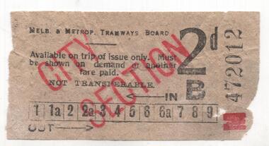 Melbourne Tram Museum
Ephemera - Ticket, Melbourne & Metropolitan Tramways Board (MMTB), Ticket - 2d, c1928?
Ticket - 2d black printing on off white paper, over printed in red for "City Section". Ticket No. M472012. Has a Fishers Ink advert on rear. See htd3959doc.pdf for a detailed investigation of the ticket, where it was found and discussions with the donor. Summary - found in an archaeological dig for 74 Collins St - see htd3959doc1.pdf - which gives the background to the history of the site. Ticket found nearby a 1928 paper. Gary Davey, see htd3959doc for background could not date the ticket, though is landscape format and single row of punch marks are of note. Most likely c1928. Images i3 and i4 are of the docket that was received with the ticket from the dig and the donors name.trams, tramways, tickets, city section, advertisements -
 Federation University Historical Collection
Ethnographic, Possible Aboriginal Axehead
Possible stone axehead made of limestone with fractures aboriginal, stone tool, stone, axe, axehead, limestone, archaeology -
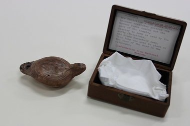 Warrnambool Art Gallery
Oil lamp, c. 100BC
It is unknown how this came into the collection at the Warrnambool Museum. However, during the 18th and 19th centuries it was fashionable for young men of means to undertake a 'grand tour'. During their travels they would often pick up souvenirs with these sometimes being ancient artefacts from classical Greece or Rome. It is thought that the item most probable came to the museum in this manner.From discussion with specialists at the British Museum and the University of Reading it was ascertained that the oil lamp is indeed ancient Roman and over 2000 years old. The marking on the top could be Venus although it is quite worn away so it is difficult to tell for sure.A terracotta oil lamp housed in a wooden box. On the top of the lamp are 3 circle incisions and in the centre of the circles is a depiction of a figure. There is a small finger sized handle on the side of the lamp. The handle has 2 incised lines leaving 3 raised ridges. It is squared off at the top. The top of the oil lamp has a hole in which to place a cloth wick and a spout from which the smoke would have come out. The spout is blackened from smoke. The container box is guessed to be from the time of acquisition which would be around the early 1900s and is made from a polished wood. Light in colour.In the box was a label saying, 'Venus coming out of the gate of the temple'. It also stated that the lamp may have been placed at the feet of the dead in the catacombs.oil lamp, roman, terracotta, classical, archaeology, victorian, grand tour