Showing 428 items
matching balconies
-
 RMIT Design Archives
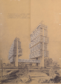
Diazotypes, Robin Boyd's Sketch for combined project 60-64 Clarendon St + corner site, 1968
Robin Boyd’s unbuilt scheme for two residential towers for Carnich Pty Ltd in East Melbourne is one of his most striking late projects – remarkable for its daring scale, its indebtedness to the megastructural polemics of Paul Rudolph and Japanese Metabolism, and its prescience – a high-rise apartment building now sits on the same site. The drawing is spectacular: trays of space are held aloft on angled concrete props that branch off trunk-like vertical slabs. With balconies and spandrels highlighted in white, the scheme’s dynamism echoes El Lissitzky’s mad Wolkenbugel (‘Skyhooks’) while also signalling a tragic last hurrah before Boyd’s 1971 death. Philip GoadIncludes sketch of two structures and surrounding flora.Inscribed upper left of recto, "ROBIN BOYD'S SKETCH FOR / COMBINED PROJECT 60-64 / CLARENDON ST. + CORNER SITE"architecture, mid-century modern, emigre, rmit design archives -
 Melbourne Legacy
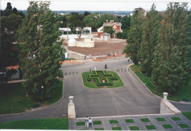
Photograph, Legacy Garden of Appreciation, 1998
A photo of the Legacy Garden of Appreciation at the Shrine of Remembrance taken from the balcony of the Shrine in September 1998 after the installation of the statue of the Widow and Children. It is called the Garden of Appreciation 'marking the generosity of Victorians in supporting Legacy in its work of assisting widow sand children of deceased veterans'. The 'Widow and Children' statue was commission by Legacy and installed in 1998. The Garden is in a cruciform shape and is on the eastern side of the Shrine Reserve near Birdwood Avenue. It was formerly called the Garden of Memory from 1980-1986 according to Monument Australia website. One plaque explains 'the garden features the Flanders Fields poppies, the seeds which came from Villers-Bretonneux, France'. A record the Legacy garden at the Shrine after the statue was installed in 1998.Colour photo of the Legacy Garden of Appreciation at the Shrine of Remembrance.Handwritten on the reverse in blue pen 'Sept 1998'.shrine of remembrance, memorial garden -
 Surrey Hills Historical Society Collection
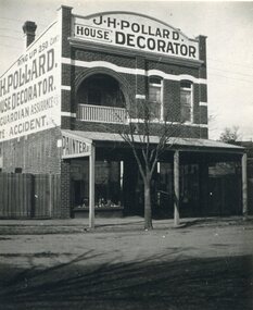
Photograph, Shop of J H Pollard, House Decorator, at 139 Union Road, Surrey Hills, 1930
This site was later occupied by Mitton's pharmacy. James Henry Pollard appears on the 1903 electoral roll as a painter in Canterbury Road (in one of the buildings that made up Hansen's Terrace.)The Union Road shops are covered by a City of Boroondara Heritage Overlay. This particular shop has changed very little with some alteration to the upper storey when it was repurposed for residential dwelling.Black and white photo of James Henry Pollard's shop at 139 Union Road, Surrey Hills in 1930. It is a 2 storey brick building with 2 glass display windows either side of the door and a corrugated iron roofed verandah supported on 3 posts. Above is a dwelling with 2 sash windows and an interior balcony within an arch. A wooden paling fence adjoins on the left. The side of the building and the front pediment carry advertising for the business. From this it appears that James Henry Pollard was an insurance agent for Guardian Assurance Company as well as being a house painter and decorator. There is a deciduous tree in the front of the shop.businesses, shops, mitton's pharmacy, guardian assurance company, union road shops, james henry pollard, painter, decorator -
 Melbourne Legacy
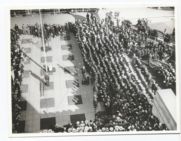
Photograph - Photo, Anzac commemoration for students, 194?
A Legacy ceremony at the Shrine of Remembrance. One of the annual "Anzac Commemoration Ceremony for Students" events, usually held just prior to ANZAC Day. The ceremony provides a valuable opportunity for students to gain an appreciation of the Anzac spirit, the significance of the Shrine and the meaning of Anzac Day. The year is unknown but barricades and flagpole are similar to the 1945 photos. The photos are an aerial view of the crowd and the flagpole, with the Australian flag at half mast, as viewed from the Shrine balcony. Items were in an envelope with other photos and programmes from different School Student ceremonies. Labelled S15 in red pen it was part of an old archive numbering system, that showed there has been efforts in the past to collect, order and save items of Legacy's history.A record of a ceremony for school students at the Shrine.Black and white photo x 2 of an Anzac Commemoration Ceremony for students at the Shrine.Stamped with purple copyright stamp of The Age and The Leader. anzac commemoration for students, wreath laying ceremony -
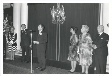 Melbourne Legacy
Photograph, Legacy 50th Anniversary, 1973
Photos of an event for Legacy at Queen's Hall in the Victorian Parliament House. Exact event and date unknown but stored with items of the 50th Anniversary celebrations in 1973. The photos show President Geoff Handbury making a speech and his wife Helen (in black gloves), Dame Mary Herring and Sir Edmund Herring to the right hand side of the photo. Also views from a balcony down on the attendees. Photo came from an envelope marked P1 Federal Conference 1973 / 50 Year anniversary / 1983 Morewell / 1973 Legacy March ANZAC Day, 50 yr celebration, inclusion in ANZAC Day March authority of RSL". See items 00451 to 00455, 00460 to 00464, 00391, 01418, 01419. A record of an event at Parliament house to mark the 50th anniversary of Legacy during the Golden Jubilee year 1973.Black and white photo x 4 an event held at Parliament house for Legacy in 1973.All stamped "This Photograph is with the compliments of the Ministry of Tourism, Government of Victoria. Please acknowledge Michael Cheshire" in grey ink.golden jubilee, legatee event -
 Bendigo Historical Society Inc.
Photograph - EDITH LUNN COLLECTION: PHOTOS OF THE REAR OF DR. O. PENFOLD'S SURGERY ON VIEW STREET, BENDIGO, 6/04/1996
Photographs of the rear of Doctor O. Penfiold's suregy /building on View Street Photographs taken 6/04/1996 11A Balcony of Dr. O. Penfold's home at the rear of his surgery in View Street 11B gaate post at entrance off View Street, of Births, deaths aned Marriages Registery at the rear of Temperance Hall, Niew Street 11C rear of residenceof Dr. O. Penfold's home behind his surgery on View Street. Photo notes the residence (possibly) originally built for Robert Strickland, barrister in 1871 11D rear of Dr. O. Penfold's home behind his surgery in View StreetEdith Lunn -
 Bendigo Historical Society Inc.
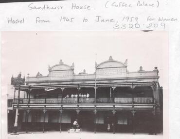
Photograph - LA TROBE UNIVERSITY BENDIGO COLLECTION: SANDHURST HOUSE
A black and white photograph of Sandhurst House now demolished. The building was situated on the corner of Mollison and Mitchell Streets and was used for female student accommodation from 1945 through 1959. Prior to this it was known as the Sandhurst Coffee Palace or Coffee Palace. It was a two storey building with two pediments at the top of the building. Each pediment had a sign Heywood Sandhurst House. On the balcony at the front can be seen seven adults looking out over the street. A gentleman is riding his bicycle in the foreground and a woman is at the front door. St. Paul's Cathedral can be seen in the background on the left hand side. See 3320. 100.bendigo, education, accommodation, la trobe university bendigo collection, collection, bendigo, accomodation, bendigo teachers' college, students, building, site, place, hospitality, entertainment, sandhurst coffee palace, coffee palace, photograph, photographs, photo, history -
 Melbourne Legacy
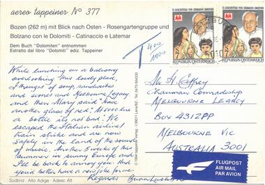
Postcard - Document, postcard
A postcard to the Comradeship Committee when a Legatee was travelling in Austria. "Bozen mit Blick each Osten" which translates as "Bolzano with view to the east". It is addressed to Mr H Caffrey, Chairman Comradeship at Melbourne Legacy. It is not dated and is signed Brian Lucky Luscombe. It says: "While lunching on a balcony overlooking this lovely place, I thought of soup, sandwiches and scones and Melbourne Legacy. And then Mary said "have another glass of red". At 6000 lire a bottle it's not too bad. We escaped the Italian airline/train strike and are now safely in the land of the Sound of Music. Another 5 weeks of this summer in sunny Europe and I'll be back to annoy you. And you'd better have a new job for me. Regards. Brian Lucky Luscombe.A record of a Legatee travelling and relating experiences back to his comrades in Melbourne.Colour postcard from Austria.Printed "Bozen mit Blick each Osten". Two Austrian postages stamps and an Airmail sticker. Handwritten text in blue pen.comradeship, legatee -
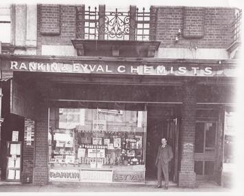 Glen Eira Historical Society
Photograph - Glenhuntly Road, Elsternwick
... Balconies ...11 photographs of Glen Huntly Road, Elsternwick, from horsedrawn carriage days to the 1980s: A black and white photograph (200mm x 253mm) of Hulbert Gorrie standing outside the shop front of Rankin and Eyval Chemists at 35 Glen Huntly Road Elsternwick. Date and photographer unknown. Three black and white photographs (107mm x 130mm; 88mm x 140mm; 88mm x 88mm) of shop fronts on Glen Huntly Road taken in different eras. A horse drawn vehicle and women in long dresses are shown in one of the photographs. The other two most likely date to the 1960s. Exact dates and photographers unknown. Seven colour photographs of advertising signs revealed when a building on Glen Huntly Road was demolished in the 1980s to build the Bank of New South Wales.gorrie hulbert, rankin and eyval chemists, cast iron work, pharmacies, balconies, chemists, architectural features, advertising signs, selwyn street, p calandro and co, estate agents, elsternwick, chinese café, j higgins, glen huntly road -
 Wodonga & District Historical Society Inc
Album - Ringer's River by Des Martin - Settings
Image 1: "de KERILLEAU" - Alongside Wodonga, home of the Watson family, was built by Charles Huon de Kerilleau, founder of the Wodonga Run. Huon took up his country in 1836, living then about 13 miles from the present homestead, the front portion of which was built about 1870. The actual age of an earlier portion is not known. Excellent for "Barmagulla". Image 2: "THE HERMITAGE" - Home of the Taylor family, is 13 miles from Wodonga. It was begun in 1852 and finished in 1854, and is the oldest occupied home in the area. The original atmosphere of the interior is maintained. As "Gooloora" its little balcony would provide a splendid vantage point for MacLough's speech. Image 3: Murray River Country above Granya, Victoria Image 4: Looking over Murmungee from the Buckland Gap near Beechworth, VictoriaThe album and images are significant because they document literature written by a prominent member of the Wodonga community. The presentation of this precis was supported by several significant district families and individuals.Coloured photos of venues suggested as settings for filming of the series. des martin, many a mile, ringer's river, northeast victoria stories -
 Wodonga & District Historical Society Inc
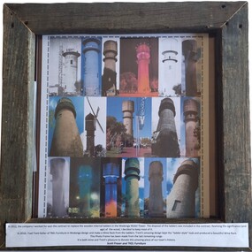
Memorabilia - Water Tower Picture Frame
The Water Tower is a major landmark of High Street, Wodonga. Construction of the Water Tower was completed in early 1924 and after thorough testing throughout that year, the completed new water system for Wodonga was officially opened on 4th December 1924. It was decommissioned in 1959. It stood unused until the lower section was modified and put to use as “ The Tower’s Cobbler’s Inn” in 1962. In 1972 Wodonga City Council proposed to demolish the Tower. Their suggestion received an unfavorable response from the city’s citizens, so the Tower still stands today. The community celebrated its centenary on 4th December 2024. This picture frame was created from timber taken from the ladders that were inside the Tower, allowing access to the water tank itself and the external balconies. It was donated to the Wodonga & District Historical Society at the Centenary Celebration.This item is significant because it is made from timber from the original ladders inside the Wodonga Water Tower.A timber frame made from sections of timber from the ladders once part of the Wodonga Water Tower.On sign at base on frame: In 2012, the company I worked for won the contract to replace the wooden internal ladders in the Wodonga Water Tower. The disposal of the ladders was included in the contract. Realising the significance (and age) of the wood, I decided to keep most of it. In 2018, I had Trent Keller of TKEL Furniture in Wodonga design and make a Wine Rack from the ladders. Trent's amazing design kept the "ladder-style" look and produced a beautiful Wine Rack. This Photo Frame has been made from the last remaining rungs. it is both mine and Trent's pleasure to donate this amazing piece of our town's history. Scott Fraser and TKEL Furniturewodonga water tower, landmarks wodonga -
 Bendigo Historical Society Inc.
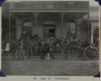
Photograph - DELIVERY OF GOLD TO ORIENTAL BANK, HIGH STREET, EAGLEHAWK, 1907
Black and white photograph of group of males and two small girls at Oriental Bank. Building with cast iron balcony. Horse and jinker. One man mounted on horse. Photo attached to cream card with blue corners. Inscriptions: on front - 'Sam Bartlett on left (bearded), hand printed at BL. '54 High St. Eaglehawk', 'HJG Biggs, Health Inspector'. On back - circular stamp 'Royal Historical Society of Victoria, Bendigo Branch'. History: Gold from the South New Moon Mine, Eaglehawk. Delivered in 1907 to the Oriental Bank. Mine Manager Sam Bartlett on the left of gold (with beard)' James Lerk 19/11/1999. Previous Acc. No. GP35person, group, employees -
 Bendigo Historical Society Inc.
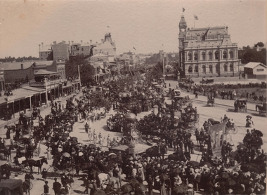
Photograph - PALL MALL PROCESSION
Black and White photograph. The photo shows large procession heading north up Pall Mall. On RH side of image: Law Courts, Union Jack flag flying overhead. Conservatory Gardens just visible, picket fence along footpath. In centre of image: procession with horse drawn floats; float in front of image has large ball above an ornate supporting structure. Written on side of ball ' Gold .tained…' (gold contained?) On LH side of image, 'Harry Davey’ and 'F. Davey' written on shop fronts. All shops along Pall Mall have verandahs. Many people are sitting on balconies and rooftops watching the parade.bendigo, streetscape, pall mall -
 Mt Dandenong & District Historical Society Inc.
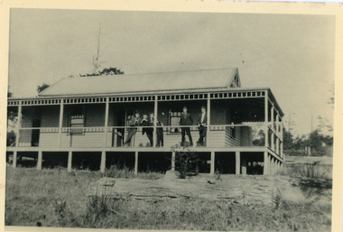
Photograph, 'Folly Farm' in Falls Road, Olinda 1914, 1914
Dr Leonard Bell Cox (1894-1976) was a noted neurologist and collector. He had a family cottage 'Folly Farm' at Olinda, the garden of which had input from Edna Walling. He moved permanently to 'Folly Farm' in 1962. In his glasshouse, he propagated and cultivated rhododendrons and camellias, and gathered rare species. He helped to form the National Rhododendron Garden at Olinda, providing many specimens from his beautiful garden. This photograph showing a group of people on the balcony of 'Folly Farm' was taken in 1914 and the cottage looks to have been newly built. The descriptive text on the reverse of this photograph was hand written by John Lundy-Clarke. Dr Cox’s “Folly Farm” Falls Road Olinda. Lot 19 Section 3 Village Settlement. Taken 1914 copied 1974 by J.L.C. folly farm, olinda, dr leonard bell cox, dr cox, edna walling, rhododendron garden -
 Alfred Hospital Nurses League - Nursing Archive
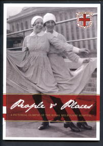
Book - Illustrated book, Susan Sherson et al, People and places; a pictorial glimpse of the Royal Melbourne Hospital, 2012
The story of nursing at the Royal Melbourne Hospital as told in pictures. Comprising of 100 annotated photographs from the RMH Archives, the images give a rare glimpse of the places and people that marked the learning experience and lives of thousands of young nurses who graduated from the RMH nursing schollBook has black and white photo of "Cav and Pag" in a rooftop performance, Melbourne Hospital, Lonsdale Street 1928 on front cover. On the back cover is a black and white photo "fresh air for all"-patients on the balconies of the Lonsdale Street hospital in1916. These photos have white borders. Also on front cover is the hospital crest prior to 1935. There is 46mm wide maroon coloured band between two narrow gilt stripes near bottom of cover. On this band, title is printed in white and gilt in, on front cover, on back cover synopsis of book is printed in white ink. Title is also printed in gilt ink on white coloured spine. Approximately 100 photos from RMH Archives within.non-fictionThe story of nursing at the Royal Melbourne Hospital as told in pictures. Comprising of 100 annotated photographs from the RMH Archives, the images give a rare glimpse of the places and people that marked the learning experience and lives of thousands of young nurses who graduated from the RMH nursing schollroyal melbourne hospital-nursing-history, royal melbourne hospital-history, nurses-victoria-history, hospitals - victoria - history -
 Flagstaff Hill Maritime Museum and Village
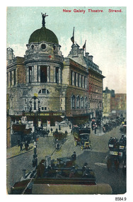
Postcard - Historical, building, New Gaiety Theatre, Strand, 1905-1907
The nine postcards in this set were donated together and date to the early 1900s. All but one postcard in this set shows images of Warrnambool, in the Western District of Victoria; the other has a London image. The postcards were all printed in Great Britain according to that country’s postal regulations. The fronts of all cards have titles printed in red. Most of the images on the cards are attributed to photographer Joseph Jordan and belong to the Jordan Series. The back of these cards has an outline for a postage stamp, a vertical dividing line and a heading on each side of the line to separate the Correspondence from the Address. However, this postcard is the 'odd one out' in that its location is London, it has no border, it has no reference to 'Jordan' or 'Jordan Series' no reference to the printer, no 'correspondence heading', it is slightly smaller than the others, and it has text in the stamp area that refers to 'inland' and 'foreign' postage, a half-penny inland and one-penny overseas.. Postcards or ‘correspondence cards’ appeared in Britain in 1894. They were plain cards with a space for the message on one side and an address on the other; regulations didn’t allow anything but the address to be written on the ‘address’ side. In 1902 the British regulations then allowed a picture to be printed on the front and the address on the back, so messages had to be written on the picture side. Soon, the regulations changed and the back was divided for a message and the address. New Gaiety Theatre, Strand [London] - The New Gaiety Theatre opened in 1903 on the corner of The Strand and Aldwych, London. The second show performed in the new theatre was “The Spring Chicken” in 1905. The third show followed in 1907. The preprinted postage cost on the stamp outline is ½ d. or half penny; according to The Great Britain Philatelic Society, Great Britain Postcard Stamps were priced 1/2 d. or Half Penny from 1-Oct-1870 to 3-Jun-1916. The postcard is significant for its inclusion with a set of nine postcards, eight of which are images of Warrnambool and its district and photographed by Joseph Jordan. It is also curious for is lack of connection to Jordan. Postcard, one of nine, portrait orientation, coloured print. The image shows a tall three-storey corner building with a statue on its domed tower and smaller towers on the sides. The top two storeys have balconies with columns, and overhang the ground floor, providing cover over the footpath. The foreground has horse-drawn carriages and coaches, and motorised vehicles including a bus. Figures wearing top hats and others in long dresses are in front of the building, which has a sign on the corner advertising the building and its current show. There is no correspondence written on the card. The front of the postcard has a printed red title and an inscription on the image. The reverse has inscriptions and outlines for a postage stamp. Made in Britain.Sign on the image of the building: “GAIETY / SPRING CHICKEN / THEATRE” On the front in red: “New Gaiety Theatre, Strand” On the back in printed in green: Stamp box “INLAND / 1/2d.’ STAMP / FOREIGN 1d.” “POST CARD” “THE ADDRESS ONLY TO BE WRITTEN HERE” flagstaff hill maritime museum, flagstaff hill maritime village, flagstaff hill maritime museum and village, maritime museum, warrnambool, great ocean road, warrnambool and district, warrnambool scenes, local scenes, views of warrnambool, postcard, souvenir, correspondence, cameo postcard, new gaiety theater, the strand, spring chicken, gaiety theatre, london theatre -
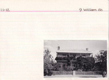 The Beechworth Burke Museum Research Collection
Card (Series) - Index Card, George Tibbits, 9 William Street, Beechworth, 1976
George Tibbits, University of Melbourne. Faculty of Architecture, Building and Town & Regional PlanningIndex system that support the research for Beechworth : historical reconstruction / [by] George Tibbits ... [et al]Arranged by street names of BeechworthEach index card includes: street name and number of property, image of property, allotment and section number, property owners and dates of ownership, description of the property according to rate records, property floor plan with dimensions.beechworth, george tibbitsbeechworth, george tibbits -
 Melbourne Legacy
Photograph - Photo, Anzac commemoration for students
A Legacy ceremony at the Shrine of Remembrance. One of the annual "Anzac Commemoration Ceremony for Students" events, usually held just prior to ANZAC Day. The ceremony provides a valuable opportunity for students to gain an appreciation of the Anzac spirit, the significance of the Shrine and the meaning of Anzac Day. The year is unknown but barricades and flagpole are similar to the 1945 photos. 01195.1 shows school children playing bugles. 01195.2 and 01195.3 show school girls with floral wreaths sitting on the forecourt. 01195.4 and 01195.5 are aerial views of the crowd and the flagpole, with the Australian flag at half mast, as viewed from the Shrine balcony. Items were in an envelope with other photos and programmes from different School Student ceremonies. Labelled S15 in red pen it was part of an old archive numbering system, that showed there has been efforts in the past to collect, order and save items of Legacy's history.A record of a ceremony for school students at the Shrine.Black and white photo x 5 of an Anzac Commemoration Ceremony for students at the Shrine.Photos are stamped with purple copyright stamp of The Argus with identifying numbers, (M2351, M2469-C, M2469-D, M2469-A) in pencil. anzac commemoration for students, wreath laying ceremony -
 Kew Historical Society Inc
Plan, Melbourne & Metropolitan Board of Works : Borough of Kew : Detail Plan No.1585, 1904
The Melbourne and Metropolitan Board of Works (MMBW) plans were produced from the 1890s to the 1950s. They were crucial to the design and development of Melbourne's sewerage and drainage system. The plans, at a scale of 40 feet to 1 inch (1:480), provide a detailed historical record of Melbourne streetscapes and environmental features. Each plan covers one or two street blocks (roughly six streets), showing details of buildings, including garden layouts and ownership boundaries, and features such as laneways, drains, bridges, parks, municipal boundaries and other prominent landmarks as they existed at the time each plan was produced. (Source: State Library of Victoria)This plan forms part of a large group of MMBW plans and maps that was donated to the Society by the Mr Poulter, City Engineer of the City of Kew in 1989. Within this collection, thirty-five hand-coloured plans, backed with linen, are of statewide significance as they include annotations that provide details of construction materials used in buildings in the first decade of the 20th century as well as additional information about land ownership and usage. The copies in the Public Record Office Victoria and the State Library of Victoria are monochrome versions which do not denote building materials so that the maps in this collection are invaluable and unique tools for researchers and heritage consultants. A number of the plans are not held in the collection of the State Library of Victoria so they have the additional attribute of rarity.Original survey plan, issued by the MMBW to a contractor with responsibility for constructing sewers in the area identified on the plan within the Borough of Kew. The plan was at some stage hand-coloured, possibly by the contractor, but more likely by officers working in the Engineering Department of the Borough and later Town, then City of Kew. The hand-coloured sections of buildings on the plan were used to denote masonry or brick constructions (pink), weatherboard constructions (yellow), and public buildings (grey). This plan, which covers parts of High Street, Pakington Street and Derby Street is dominated by two historic Kew mansions: ‘Konetta’ and ‘Ramornie’. Ramornie was constructed in 1890 for James Maitland Campbell, three times Mayor of Kew. Sold in 1940, it became a boarding house known as ‘The Towers’. Now a private residence again, it has only one of its three balconies remaining. The location of the missing two balconies can be seen on the plan. In 1903, the grounds of Ramornie included a large tennis court fronting Pakington Street. The rear of the property is shown as extending to Cobden Street. One of Kew’s oldest hotels, the Prospect Hill Hotel on the corner of High and Cobden Street was established in 1858. The outline of the hotel shown on the plan represents the second building on the site. During the 19th century it was often used for electoral meetings. The Prospect Hill Hotel was to be redeveloped again in 1928, by the local architect Robert McIntyre. Since the 1980s, the hotel has been a live music venue, the home of the Melbourne Jazz Club, a restaurant and a liquor outlet.melbourne and metropolitan board of works, detail plans, maps - borough of kew, mmbw 1585, cartography -
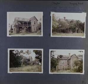
 Glen Eira Historical Society
Article - Portavoe, Alma Road, 359, Caulfield North
... Balconies ...Photocopied photo of Portavoe and extract from Andrew Ward’s 1994 conservation study of home. Describes architect- vrol features, history and significance of the house. Gives brief history of owner/occupant from 1903 to 1908.alma road, kooyong road, verandahs, chimneys, portavoe, bon accord, stained glass, edgar john m., edwardian style, ward andrew, muntz street, federation style, caulfield north, mansions, slate tiles, balconies, bay windows -
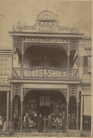 Bendigo Historical Society Inc.
Photograph - ABBOTT & CO BOOT AND SHOE MANUFACTURERS, c.1900
Sepia toned photograph of two story building. Cast iron supports to verandah and balcony. Ornate cast iron trim. New Times sign on parapet. Various sale signs on windows and front doors. Hitching post? In front of shop. Bags of grain, two males, 1 femal figures, four adolescents in front of building. Brick gutter. Wooden case on right. 'Abbott's & Co. Pall Mall Bendigo Boot and Shoe Store' . Check directories for dates of occupation. James Lerk 17/12/1999. History of object: The very flamboyant front for Abbott & Co Boot and Shoe Manufacturers. Abbotts conducted a tannery at Sheepwash - a wonderful example of an industry 'adding'. Photos. C1900. James Lerk caption.buildings, commercial, abbotts boot & shoe manufacturers -
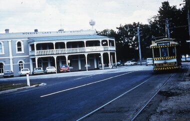 Ballarat Tramway Museum
Slide - 35mm slide/s, late 1960's
Agfa plastic mount (blue base, white cover) of a photograph of No. 14, en route to the View Point terminus in Wendouree Parade. Photo take late 1960's. Tram has destination of View Point and has a Twin Lakes sign on the front end. Has Morris's Lake View Hotel in the background. The hotel has a "Fosters Lager" symbol on the front of the building and a banner "Ballarat Regatta / February 2" banner on verandah balcony fence. The slide appears to be a copy slide, given the nature of the colour and the additional number WP403. Photographer could be Bill Pearce (WP). Slide rescanned at 3200 dpi 25-10-2020, jpg replaced, tiff file retained. This file was scanned in 2003 and may show colour changes."BAS 59 and "Tram 14" in pencil.tramways, trams, view point, wendouree parade, lake view hotel, tram 14 -
 Glen Eira Historical Society
Album - Album page, Presentation Convent (ex "Cambria), Neerim Road, Circa 1972
... balconies ...This photograph is part of the Caulfield Historical Album 1972. This album was created in approximately 1972 as part of a project by the Caulfield Historical Society to assist in identifying buildings worthy of preservation. The album is related to a Survey the Caulfield Historical Society developed in collaboration with the National Trust of Australia (Victoria) and Caulfield City Council to identify historic buildings within the City of Caulfield that warranted the protection of a National Trust Classification. Principal photographer thought to be Trevor Hart, member of Caulfield Historical Society. Most photographs were taken between 1966-1972 with a small number of photographs being older and from unknown sources. All photographs are black and white except where stated, with 386 photographs over 198 pages. References cited above indicate that Cambria was demolished around 1974-1976 (2 dates given). Caulfield's Built Heritage states it was built for Cyril Godby with the National Trust (Victorian Heritage Database) saying it was built in 1888.Page 144 of Photograph Album with two photographs (one portrait, one landscape) of Presentation Convent, Neerim Road.Handwritten: Presentation Convent (ex- "Cambria") Neerim Road [top] / 144 [bottom right]trevor hart, presentation sisters, cambria, presentation convent, roseberry grove, glen huntly, neerim road, convent, victorian, polychrome bricks, mansions, gates, verandahs, balconies, towers, lookouts, cyril godby, house names -
 Glen Eira Historical Society
Album - Album page, Neerim Road, Circa 1972
... balconies ...This photograph is part of the Caulfield Historical Album 1972. This album was created in approximately 1972 as part of a project by the Caulfield Historical Society to assist in identifying buildings worthy of preservation. The album is related to a Survey the Caulfield Historical Society developed in collaboration with the National Trust of Australia (Victoria) and Caulfield City Council to identify historic buildings within the City of Caulfield that warranted the protection of a National Trust Classification. Principal photographer thought to be Trevor Hart, member of Caulfield Historical Society. Most photographs were taken between 1966-1972 with a small number of photographs being older and from unknown sources. All photographs are black and white except where stated, with 386 photographs over 198 pages. "Edenkillie" was the home of Frederick Jowett, Caulfield's shire secretary and town clerk from 1887 to 1921. The Outer Circle Railway's Oakleigh section opened 1890 and closed 1895. Victorian Heritage database (as of 26/10/2021) HO45 Edenkillie https://vhd.heritagecouncil.vic.gov.au/places/35545 "Edenkillie" at 37 Neerim Road, Glenhuntly, is a substantial two storeyed polychrome brick villa, built for Frederick Jowett, municipal secretary, in 1890. It has aesthetic, historical and social significance. "Edenkillie's" aesthetic value derives from its survival as a substantially intact example of a common villa form expressed in polychrome brickwork. Its historical significance lies in its association with Frederick Jowett, Shire of Caulfield secretary and town clerk for over three decades. Its social significance is derived from the building's ability to demonstrate the kind of lifestyle which a local government administrator could enjoy during the Land Boom.Page 145 of Photograph Album with four landscape photographs from Neerim Road: two photographs of No 37 and two of the Outer Circle Railway Reserve.Handwritten: Neerim Road [top left] / 37 NEERIM ROAD 1OCT 1972 [under top left photo] / 37 NEERIM RD 1 OCT 1972 [under top right photo] / OUTER CIRCLE RAILWAY RESERVE MURRUMBEENA [under bottom left photo] / 145 [bottom left]trevor hart, neerim road, murrumbeena, caulfield, edenkillie, glen huntly, polychrome brick, mansions, frederick jowett, town clerks, shire of caulfield, outer circle railway, railways, parks and reserves, outer circle railway reserve, cast iron work, verandahs, balconies -
 Glen Eira Historical Society
Album - Album page, Orrong Road, Circa 1972
... balconies ...This photograph is part of the Caulfield Historical Album 1972. This album was created in approximately 1972 as part of a project by the Caulfield Historical Society to assist in identifying buildings worthy of preservation. The album is related to a Survey the Caulfield Historical Society developed in collaboration with the National Trust of Australia (Victoria) and Caulfield City Council to identify historic buildings within the City of Caulfield that warranted the protection of a National Trust Classification. Principal photographer thought to be Trevor Hart, member of Caulfield Historical Society. Most photographs were taken between 1966-1972 with a small number of photographs being older and from unknown sources. All photographs are black and white except where stated, with 386 photographs over 198 pages.Victorian Heritage Database https://vhd.heritagecouncil.vic.gov.au/places/35576 No. 70 Orrong Road is important as an exceptionally ornate Boom style villa residence in the terraced form and in this respect is rare in Caulfield. Its architectural value is enhanced by its intact state and by the manner in which its bold architectural expression is carried through into the hallway and staircase. Victorian Heritage Database - National Trust local significance 284 Orrong Road Caulfield https://vhd.heritagecouncil.vic.gov.au/places/65700 A house designed by Harold Desbrowe Annear in 1917 and believed to have been the first "all electric" house in Melbourne. It has been extensively altered.Page 164 - four photographs of 2 different houses on Orrong Road. The top left photo is in colour while the others are in black and white.Handwritten: Orrong Road [top right] / Lisborn House [ (ed. correct name is LISBON HOUSE), under top left photo] / Lisborn House [under top right photo] / [under bottom right photo] / CORNER ORRONG ROAD AND PEARSON AVENUE / HOUSE BY DESBROWE ANNEAR [under bottom left photo] / 164 [bottom right]trevor hart, orrong road, lisbon house, lisborn house, elsternwick, pearson grove, st kilda east, caulfield north, terrace houses, cast iron work, verandahs, balconies, parapets, arches, cars, streetscapes, attic houses, desbrowe annear -
 Eltham District Historical Society Inc
Photograph - Digital Photograph, Marguerite Marshall, Former home of Professor William MacMahon Ball, York Street, Eltham, 24 May 2007
Situated at the eastern end of York Street, Eltham, 'Shinrone', the former home of Professor William (Mac) MacMahon Ball was one of the first in the Shire of Eltham to incorporate mud-brick. Professor MacMahon Ball, a political scientist, writer, broadcaster and diplomat and family moved to York Street, Eltham in 1945 into a timber cottage built around the 1890s and in poor repair. Mac asked Alistair Knox to renovate the home and he expanded the living area and added verandahs. In 1948 Montsalvat artist and sculptor Sonia Skipper supervised the building of most of the mud-brick studio. Neighbour Gordon Ford made the mud-bricks. Mac also asked John Harcourt, who had worked with him as a journalist in shortwave broadcasting, to build a pise (rammed earth) and stone addition to the largely timber house. Harcourt built two bedrooms - including an attic bedroom - a balcony with a shower and toilet, and a fireplace and chimney of local stone. Published: Nillumbik Now and Then / Marguerite Marshall 2008; photographs Alan King with Marguerite Marshall.; p141This collection of almost 130 photos about places and people within the Shire of Nillumbik, an urban and rural municipality in Melbourne's north, contributes to an understanding of the history of the Shire. Published in 2008 immediately prior to the Black Saturday bushfires of February 7, 2009, it documents sites that were impacted, and in some cases destroyed by the fires. It includes photographs taken especially for the publication, creating a unique time capsule representing the Shire in the early 21st century. It remains the most recent comprehenesive publication devoted to the Shire's history connecting local residents to the past. nillumbik now and then (marshall-king) collection, eltham, alistair knox, gordon ford, john harcourt, mudbrick construction, pise construction, professor macmahon ball, shinrone, sonia skipper, york street -
 St Kilda Historical Society
Ephemera - Flyer, Welcome and Presentations to St Kilda's (1914) Anzacs, 1918
For welcome and presentations to St Kilda's (1914) ANZACs on 4 December 1918. The event is described by John Butler Cooper in 'The History of St Kilda' (pp 263-264) as follows: 'On Wednesday evening, December 4, 1918, seventy Anzacs of St. Kilda who had returned were welcomed by the St. Kilda Patriotic Committee at the City Hall. The hall was decorated with an immense bouquet of red, white and blue flowers, depending from the centre of the ceiling, with floral and electric festoons leading therefrom. Anzacs shields in laurel wreaths and flags were displayed along the balcony of the hall. Over the stage the word "Anzacs," outlined by electric lights, was surmounted with the words "Patriotic Committee of St. Kilda heartily Welcomes You." As the returned soldiers marched into the hall, they were received with cheers, and an electric button being touched, the word "Welcome" flashed in light caught their eyes. The Mayor presented the 1914 soldiers with gold enamelled medals, bearing the arms of St. Kilda.' White paper, single sheet folded, printed on 3 pages in blue.wwi, world war i, st kilda patriotic committee, citizens welcome to anzacs -
 Glen Eira Historical Society
Album - Album page, Royston, Kooyong Road, Circa 1972
... balconies ...This photograph is part of the Caulfield Historical Album 1972. This album was created in approximately 1972 as part of a project by the Caulfield Historical Society to assist in identifying buildings worthy of preservation. The album is related to a Survey the Caulfield Historical Society developed in collaboration with the National Trust of Australia (Victoria) and Caulfield City Council to identify historic buildings within the City of Caulfield that warranted the protection of a National Trust Classification. Principal photographer thought to be Trevor Hart, member of Caulfield Historical Society. Most photographs were taken between 1966-1972 with a small number of photographs being older and from unknown sources. All photographs are black and white except where stated, with 386 photographs over 198 pages. Vol 1 of 4 "Caulfield's Heritage" p34 states that this mansion was demolished in 1972.Page 114 of Photograph Album with four colour photographs (landscape) of different views of Royston in its garden.Handwritten: "Royston" Kooyong Road / 240 KOOYONG ROAD / 1939 - SLATTER - MISS MAY EDITH ALICE. [top right] / 114 [bottom right]trevor hart, caulfield north, kooyong road, 1860's, villa residence, victorian, mansion, ornamented corner stones, royston, renwick, curved windows, timber verandahs, return verandahs, bay windows, may edith alice slatter, may slatter, balconies, polychrome bricks, abandoned buildings -
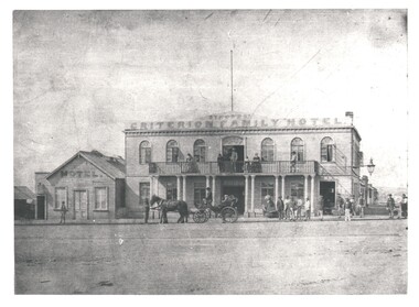 Bendigo Historical Society Inc.
Photograph - WES HARRY COLLECTION: SYMONDS' CRITERION FAMILY HOTEL, BENDIGO
Photograph of a double storied stone building, it has a three quarters length open verandah along the first floor. The name 'Symonds Criterion Family Hotel' is painted above the first floor. There is a large lamp on a bracket on the right hand side of the building. To the left of the main structure there is a smaller weatherboard building with the word 'Hotel' painted along the top. There are several groups of people both on the ground and on the balcony, also in front of the hotel is a very up market buggy/wagonette with a coachman? Driving. This hotel was on the corner of Mundy and Hargreaves Streets, and is significant as centre of events as it overlooked the original Market Square. Original photo is part of the Batchelder Collection owned by the State Library of Victoria. Published in 'An American on the Goldfields' p. 38-39 with description and details. See also Mosaic No. 1232. *See Research field for further details. Symonds operated the Criterion Hotel 1858 - 1862.Batchelderbuildings, hotel, criterion family hotel, criterion family hotel. mundy street hargreaves street. market square. princess theatre. symonds, joseph s. -
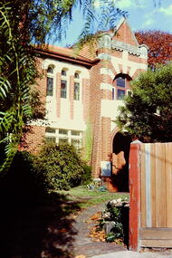 Kew Historical Society Inc
Slide - House, cnr Fellows and Barry Streets, 1979
One of a group of slides taken by members of the Society of built heritage in Kew in 1979-80. The selection of subject matter reflects the priorities of the period. The colour of some slides has degraded. This particular slide is of 'Fairholme' on the corner of Barry and Fellows Street. The building is listed by the National Trust (Victoria). The citation on the Historic Buildings Register states: 'Fairholme is of State architectural significance as a distinctive free Romanesque Revival residence. Built in two stages, 1889 for solicitor Edward Smart and early this century for importer, J K Meritt, the singular architectural character of Fairholme is achieved by combining window bays and groups of windows with a two-storey gabled porch. The deliberate and distinctively asymmetrical composition is emphasised by Art Nouveau pressed cement detailing (coprosma) on a bowed balcony and the two-storey timber verandah, which is typical of the Edwardian period. The architects were Reed, Henderson & Smart (1889) and C Gordon McCrae (c 1900-1). Internally a grand entry hall with inglenook, staircase and gallery follow the Arts and Crafts quality of the exterior. Classified: 17/03/1993'The slides represent a snapshot in time of built architecture in Kew, much of which has changed in the forty-plus period since they were created. 35mm colour transparency (slide) of 'Fairholme' (1889) on the north-east corner of the intersection of Fellows and Barry Streets, Kew. The photo was developed in May 1979.barry street -- kew (vic.), fellows street -- kew (vic.), historic houses -- kew (vic.), architects -- reed henderson & smart, architectural styles -- romanesque revival, j k merritt