Showing 3475 items matching " bridge road"
-
 Eltham District Historical Society Inc
Slide - Photograph, Main Road at Bridge Street, Eltham, c.May 1988
... Main Road at Bridge Street, Eltham...Main Road at Bridge Street, Eltham, c.May 1988... melbourne Main Road at Bridge Street, Eltham, c.May 1988 Bridge ...Main Road at Bridge Street, Eltham, c.May 198835mm colour positive transparency (1 of 36) Mount - Kodak KodachromeProcess Date MAY 88Mbridge street, eltham, infrastructure, main road, roads -
 Melbourne Tram Museum
Pamphlet, Transport Victoria, "Racecourse Road bridge Safety works, Kensington", July 2025
... "Racecourse Road bridge Safety works, Kensington"...Pamphlet titled "Racecourse Road bridge Safety works...Pamphlet titled "Racecourse Road bridge Safety works ...Pamphlet titled "Racecourse Road bridge Safety works, Kensington" distributed to residents and business in Kensington, Flemington about the proposed installation of a no right hand turn from Racecourse Road into Bellair St and from Bellair St into Racecourse Road. The pamphlet explains the purpose of the right hand turn ban to prevent high trucks doing a U turn or turning into Bellair St and striking the tram overhead in order to miss hitting the low bridge (3.7m) and other works to direct trucks to the approved routes. This is common occurance.Yields information about a long overdue process to try and stop trucks damaging the overhead at the Newmarket rail over bridge and the bridge itself.Pamhlet - printed in colour, folded A3 sheet.racecourse rd, tramways, bridges, accidents -
 Orbost & District Historical Society
black and white photographs, 1975
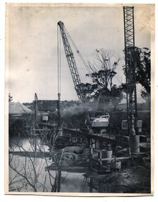
... Snowy-River-bridge-Orbost road-construction-Orbost bridge... cement road bridge across the Snowy River at Orbost. Construction... of a road bridge across a river. 3257.1 shows piles being dropped... cement road bridge across the Snowy River at Orbost. Construction ...These are photographs of the construction of the current cement road bridge across the Snowy River at Orbost. Construction of the bridges commenced in January 1975, with an expectation to open the bridge across the Snowy River as soon as possible. Less than two years later, on 25 November 1976, the bridge across the Snowy River was opened to traffic, allowing the old bridge to be demolished. The remainder of the Orbost Bypass, both the floodplain crossings and the eastern section around the township itself, was declared ‘Princes Freeway’ and opened to traffic in December 1977. (ref http://mrv.ozroads.com.au)The opening of this Snowy River Bridge was an important development in the accessibility to the township of Orbost. These photographs record its construction.Two black / white photographs showing the construction of a road bridge across a river. 3257.1 shows piles being dropped beside the bridge, 3257.2 is of the early stages of construction of this bridge.snowy-river-bridge-orbost road-construction-orbost bridge-orbost -
 Kew Historical Society Inc
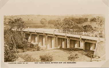
Postcard, Valentine Publishing Co Pty Ltd, New Yarra Bridge, Between Kew and Heidelberg, 1926-1930
... burke road bridge - kew (vic)... Bridge linking Bridge and Burwood Roads. A bridge across...Angle view of the new Yarra bridge [ie. The Burke Road... Bridge and Burwood Roads. A bridge across the Yarra at Burke Road ...Without bridges, Kew remained cut off from the City of Melbourne, only being accessible by Punt. Private and public bridges were constructed from the 1850s, beginning with the Hawthorn Bridge linking Bridge and Burwood Roads. A bridge across the Yarra at Burke Road was created as early as 1873. Since that first wooden bridge, a number of later bridges, typically on concrete pylons have been built, in 1926 and again during the 1970s.Angle view of the new Yarra bridge [ie. The Burke Road bridge] taken from the Kew side, showing the bridge’s structure. Trees line the river’s edge. In the distance can be seen a distant line of houses stretching to the horizon. The river appears to have an S-shaped bend beyond the bridge. The postcard, No. 227, was produced by the Valentine Publishing Co. Pty Ltd., of Queen Street, Melbourne.burke road bridge - kew (vic), bridges - kew (vic) -
 Eltham District Historical Society Inc
Document - Property Binder, 826 Main Road, Eltham
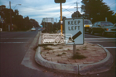
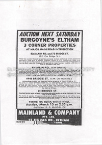
... minding centre at the corner of Bridge Road and Main Road however... minding centre at the corner of Bridge Road and Main Road however ...Photocopy advertisement, sale three corner properties at Main Road intersection, by Burgoyne family. Newspaper article: Nod for medical centre plan, Diamond Valley News, May 31, 1995 - Nillumbik Council approved plans for medical facility and chiuld minding centre at the corner of Bridge Road and Main Road however not all members of the Planning Special Committee were in support - eventually did not proceed and units were built with the address of 72 Bridge Roadmain road, eltham, property, burgoyne family, medical centre, 72 bridge street, 826 main road, bridge street, child minding centre, don cordell, jim connor, nillumbik planning special committee, tony lazzarotto -
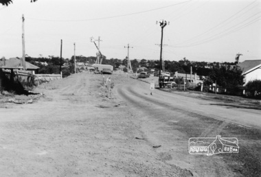
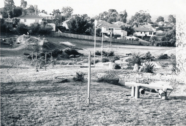
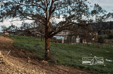 Eltham District Historical Society Inc
Photograph, Fred Mitchell, Site of the new Eltham Town Park, corner of Main Road and Bridge Street, Eltham, 1968, 1968
... Site of the new Eltham Town Park, corner of Main Road and...During the Main Road duplication. Bridge Street... melbourne During the Main Road duplication. Bridge Street ...During the Main Road duplication. Bridge Street in background to the right of picture. Eltham Town Park was later renamed Alistair Knox Park.Digital copy of colour photographfred mitchell collection, 1968, main road, road construction, duplication, alistair knox park, bridge street, eltham town park -
 Greensborough Historical Society
Newspaper Clipping, Herald Sun, Estate offers buyers a fair deal, 24/04/2010
... bridge inn road mernda... "Fairview" in Bridge Inn Road Mernda.... residential development "Fairview" in Bridge Inn Road Mernda. mernda ...This article advertises a new residential development "Fairview" in Bridge Inn Road Mernda.News clipping, text and colour image.mernda, bridge inn road mernda -
 Eltham District Historical Society Inc
Photograph, Eltham Bridge
... Photograph of bridge, Main Road, Eltham possibly taken... melbourne Photograph of bridge, Main Road, Eltham possibly taken ...Photograph of bridge, Main Road, Eltham possibly taken by Peter Bassett-Smith. No date. eltham, bridge, main road -
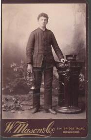 Bendigo Historical Society Inc.
Photograph - CABINET PORTRAIT OF A YOUNG MAN
... W. Mason & Co. 134 Bridge Road, Richmond...- W Mason & Co Richmond W. Mason & Co. 134 Bridge Road ...Sepia Cabinet Portrait of a young man on brown mount board. The young man is wearing a uniform and has a trumpet or bugle in his right hand. His left hand is resting on a pedestal which has a cap on it. On the cap band is: 'The Salvation Army? - - -.W. Mason & Co. 134 Bridge Road, Richmondphotograph, portrait, male, cabinet portrait of a young man, the salvat-, w mason & co richmond -
The Beechworth Burke Museum
Audio - Oral History, Jennifer Williams, Mr Tom Carey, 3/08/2000
... Bridge Road... industries in Beechworth, from the Bridge Road, Price’s Store... industries in Beechworth, from the Bridge Road, Price’s Store ...Mr Tom Carey was born in 1940 in Beechworth to family from Beechworth and Woolshed. His family had strong associations with Australia's Gold Rush, with grandparents having followed the rush from town to town, and parents in Beechworth. Tom has strong associations with Beechworth and its surrounds, with his family having some connection to the Kelly Gang. Tom worked in many industries in Beechworth, from the Bridge Road, Price’s Store, tannery, post office, the Kiewa Murray Water Authority, and the Beechworth Council. This oral history recording was part of a project conducted by Jennifer Williams in the year 2000 to capture the everyday life and struggles in Beechworth during the twentieth century. This project involved recording seventy oral histories on cassette tapes of local Beechworth residents which were then published in a book titled: Listen to what they say: voices of twentieth century Beechworth. These cassette tapes were digitised in July 2021 with funds made available by the Friends of the Burke. Mr Tom Carey account of his life in Beechworth and the local area during the 20th century is historically and socially significant to the cultural heritage of the region. He details important historical events and hardships in the region's history that had a lasting local, regional and national impact, including Australia during war time, economic struggles, and women's and men’s societal roles in a rural area. This oral history account is socially and historically significant as it is a part of a broader collection of interviews conducted by Jennifer Williams which were published in the book 'Listen to what they say: voices of twentieth-century Beechworth.' While the township of Beechworth is known for its history as a gold rush town, these accounts provide a unique insight into the day-to-day life of the town's residents during the 20th century, many of which will have now been lost if they had not been preserved. This is a digital copy of a recording that was originally captured on a cassette tape. The cassette tape is black with a horizontal white strip and is currently stored in a clear flat plastic rectangular container. It holds up 40 minutes of recordings on each sideMr Tom Carey/ beechworth, oral history, burke museum, tannery, beechworth council, kelly gang, bridge road, price’s store, post office, the kiewa murray water authority, woolshed, gold rush, carey, tom carey, listen to what they say -
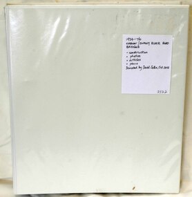 Orbost & District Historical Society
folder, Orbost Bridges - Snowy River Road Bridges, 1974 1976
... A white plastic folder - Orbost Bridges - Snowy River Road... / SNOWY RIVER ROAD BRIDGES... on the construction history of the Snowy River Road bridges. Snowy-River ...This folder was compiled in October 2015 from documents, magazines. papers and photographs donated by David Jellie, engineer in charge 1974 - 1976. In early 1974, as an Engineer with the Country Roads Board, David came to Orbost as the Supervising Engineer for the construction of the new bridges which were part of an 8.4km Orbost bypass road design. This was a major project involving not only a new bridge over the Snowy River (including Lochiel Lagoon), but other bridges over Ashby’s Gulch and Watt’s Gulch. These new bridges were opened in November 1976 with the unveiling of a plaque on the eastern end of the $2.4M Snowy River Bridge. (ref. May Leatch)This item is a useful reference tool on the construction history of the Snowy River Road bridges.A white plastic folder - Orbost Bridges - Snowy River Road Bridges. it contains newspaper articles, booklets, photographs and documents relating to the construction of the Snowy River Road Bridge in 1974 -1976.on front cover - 1974 - 76 ORBOST / SNOWY RIVER ROAD BRIDGES * construction * photos * articles * plans Donated by David Jellie Oct 2015snowy-river-bridges jellie-david -
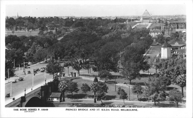 Melbourne Tram Museum
Postcard, Rose Stereograph Co, "Princes Bridge and St Kilda Road Melbourne", late 1930s
... "Princes Bridge and St Kilda Road Melbourne"... station clock tower showing Princess Bridge and St. Kilda Road... tower showing Princess Bridge and St. Kilda Road with a W2 class ...Rose Series postcard No. P 10649, titled "Princes Bridge and St Kilda Road Melbourne", looking south from Flinders St station clock tower showing Princess Bridge and St. Kilda Road with a W2 class tram in the view at the intersection of City Road to the west and Alexandra Avenue to the east. In the background is the Shrine of Remembrance. To the west of St. Kilda Road running in parallel from City Road to Mafra Street is Sloss Street, it was removed in the late 1960' for the construction of the National Arts Center. The former "Green Mill" dance hall built in 1926 become the "Forty Club" in 1933 and evolved to being the "Trocadero Palais" by the late 1930's can be seen on the right of the photo. The road on the south side of the Yarra River, at the bottom of the photo, is Riverside Avenue. Yields information about St Kilda Road, late 1930s.Postcard - printed real photograph with Rose Stereograph Co. name on the rear.trams, shrine of remembrance, st kilda road, princes bridge, w2 class, tramways -
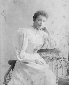 Stawell Historical Society Inc
Photograph - Portrait, Young Woman
... W. mason & Co. 150 Bridge Road, Richmond. Melbourne... Bridge Road, Richmond. Melbourne B/W Studio Portrait: Young Woman ...Huttley - Martin FamilyB/W Studio Portrait: Young Woman in white dress with puffed full length sleeves Sitting on chair leaning on whicker tableW. mason & Co. 150 Bridge Road, Richmond. Melbournehuttley, martin -
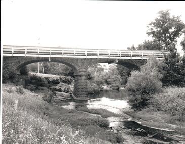 Hume City Civic Collection
Photograph, 1970s
... macedon street road bridge...A black and white photograph of the bluestone Macedon road... road bridge harris thomas lascelles jacksons creek george evans ...The bluestone bridge which spans the Jacksons Creek was built in 1857 and replaced a laminated timber bridge. In the 1970s the stone bridge was replaced with a wider cement structure to accommodate the increased traffic flow.A black and white photograph of the bluestone Macedon road bridge over the Jacksons Creekmacedon street road bridge, harris, thomas lascelles, jacksons creek, george evans collection -
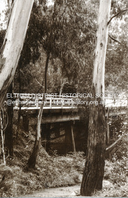
 Ringwood and District Historical Society
Photograph, Warrandyte Road Bridge over Mullum Mullum Creek, Ringwood with the higher bridge being erected. Date probably in the 1920s. Taken by M. McGivern
... Warrandyte Road Bridge over Mullum Mullum Creek, Ringwood... Road Bridge over Mullum Mullum Creek, Ringwood with the higher ...Digital photograph -
 Eltham District Historical Society Inc
Negative - Photograph, J.A. McDonald, One Tree Hill Road Bridge, Christmas Hills, 2 July 1962
... One Tree Hill Road Bridge, Christmas Hills... melbourne One Tree Hill Road Looking south 2/7/62 The bridge ...One Tree Hill Road Looking south 2/7/62 The bridge was destroyed by bushfires 15-16 January 1962. A temporary bridge was set up to the east sideRecord of various Shire of Eltham infrastructure works undertaken during the period of 1952-1962 involving bridge and road reconstruction projects, sometimes with Eltham Shire Council Project Reference numbers quoted. It was during this period that a number of significant improvements were made to roads and new bridges constructed within the shire that remain in place as of present day (2022). In many situations, the photos provide a tangible visible record of infrastructure that existed throughout the early days of the Shire. The album was put together by or under the direction of the Shire Engineer, J.A. McDonald.1962-07-02, bridge construction, christmas hills, infrastructure, shire of eltham, victorian bushfires - 1962, bush fires, one tree hill road, property damage -
 Eltham District Historical Society Inc
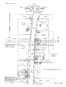
Document - Survey Plan, Country Roads Board, SP 6800, Eltham-Yarra Glen Road; Bridge St to Henry St, 1958
... SP 6800, Eltham-Yarra Glen Road; Bridge St to Henry St...-Yarra Glen Road; Bridge St to Henry St Document Survey Plan ...1958 C.R.B. Plan of Survey of Part of Crown Portions 12 and 13 Section 4 Parish of Nillumbik, County of Evelyn Eltham-Yarra Glen Road., Shire of Eltham Shows Surveyor field notes, property ownership and building type and construction.1958, a.m. gahan, a.s & s.j. davis, annie ellen davies, bridge street, country roads board, d.a. lyon, dave lyon, eltham, flora towell, g.e. gallagher, henry street, j. lyon, k. greene, main road, p.a. gahan, survey plan, w.l. chynoweth pty ltd, york street, neil webster collection -
 Eltham District Historical Society Inc
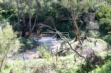
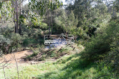
Photograph, Peter Pidgeon, Diamond Creek near Main Road Bridge, Eltham South, 8 Sep. 2021
... Diamond Creek near Main Road Bridge, Eltham South...) floods Born Digital Diamond Creek near Main Road Bridge, Eltham ...Evidence of flooding from recent winter and early spring rainBorn Digitaleltham south, diamond creek trail, diamond creek (creek), floods -
 Eltham District Historical Society Inc
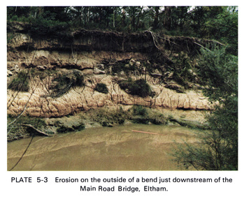
Work on paper (Sub-Item) - Photograph, Erosion on the outside of a bend just downstream of the Main Road Bridge, Eltham
... Main Road Bridge, Eltham... of the Main Road Bridge, Eltham Work on paper Photograph ...Colour photograph of a muddy Diamond Creek (probably after a downpour) with siginificant water erosion apparent at the bend of the creek in Eltham.eltham, creek, vegetation, diamond creek, erosion -
 Eltham District Historical Society Inc
Work on paper (Sub-Item) - Photograph, Arthurs Creek Road Bridge, Hurstbridge, 1885
... Arthurs Creek Road Bridge, Hurstbridge, 1885... Arthurs Creek Road Bridge, Hurstbridge, 1885 Work on paper ...Black and white photograph.bridge, hurstbridge -
 Eltham District Historical Society Inc
Work on paper (Sub-Item) - Photograph, Monash Bridge, Arthurs Creek Road, Hurstbridge, 1917
... Monash Bridge, Arthurs Creek Road, Hurstbridge, 1917... Diamond Creek Basin Study, 1980 Monash Bridge, Arthurs Creek Road ...Black and white photograph of the new bridge opened in 1917.bridge, hurstbridge -
 Greensborough Historical Society
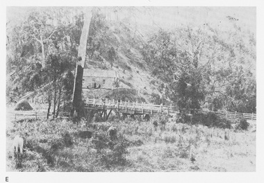
Photograph, Main Road bridge looking to township of Greensborough, 1929c
... Main Road bridge looking to township of Greensborough... including Plenty River bridge and Marble Hall on corner of Carter... and the road approaching the bridge is unsealed. The rail bridge shows ...View of Main Street Greensborough from Partington's Hill including Plenty River bridge and Marble Hall on corner of Carter Street (now Para Road) and Main Street. This view of Greensborough Park shows the old pan toilets, the hawthorn fence line and the rather undeveloped roadside area of the park. Looking up Main Street we see the old Chapman house at the corner of Poulter Avenue and some newer houses below this. The stone river bridge appears to be only a single lane wide and the road approaching the bridge is unsealed. The rail bridge shows evidence of soot from steam trains and at the extreme left of picture the two concrete buildings indicate the line had been electrified. This occurred in 1923. Sparse housing is seen in the Flintoff Street and Grimshaw Street area.Part of a collection of photographic enlargements of views of Greensborough in the early 1900s.Black and white enlargement of photographic imagemain street greensborough, marble hall, greensborough railway, chapman house, greensborough park, poulter avenue greensborough, carter street, para road -
 Greensborough Historical Society
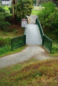
Photograph - Digital Image, Marilyn Smith, Willinda Park bridge to Simms Road, 06/11/2017
... Willinda Park bridge to Simms Road... of colour photograph Willinda Park bridge to Simms Road Photograph ...Willinda Park is situated in Beatrix Street Greensborough. It has an athletics track and field and is adjacent to the Plenty River. This photograph shows the footbridge across the Plenty River to Simms Road Reserve.Digital copy of colour photographwillinda park, beatrix street greensborough, athletics, plenty river -
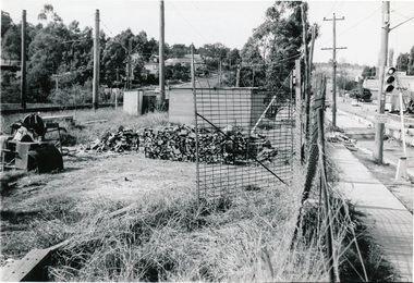
 Eltham District Historical Society Inc
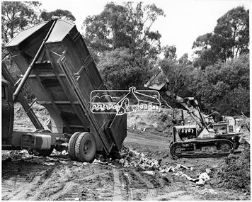
Photograph, Land Reclamation by Sanitary Land Fill Method. Main Road, Bridge Street, Diamond creek, Eltham area, November 1966
... Land Reclamation by Sanitary Land Fill Method. Main Road... Reclamation by Sanitary Land Fill Method. Main Road, Bridge Street ...Source: Shire of ElthamThis photo forms part of a collection of photographs gathered by the Shire of Eltham for their centenary project book,"Pioneers and Painters: 100 years of the Shire of Eltham" by Alan Marshall (1971). The collection of over 500 images is held in partnership between Eltham District Historical Society and Yarra Plenty Regional Library (Eltham Library) and is now formally known as the 'The Shire of Eltham Pioneers Photograph Collection.' It is significant in being the first community sourced collection representing the places and people of the Shire's first one hundred years.Digital imagesepp, shire of eltham pioneers photograph collection, eltham, road construction -
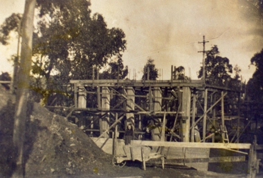
 Eltham District Historical Society Inc
Photograph, Sherbourne Road bridge construction works over railway line, Montmorency, c.1971, 1971c
... Sherbourne Road bridge construction works over railway line... melbourne eltham sherbourne road railway bridge construction ...Black and white photograph printeltham, sherbourne road, railway bridge, construction, montmorency -
 Eltham District Historical Society Inc
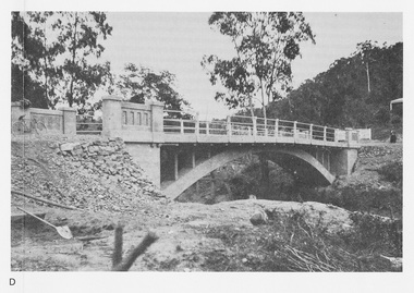
Photograph, Para Road Bridge construction, Briar Hill, near Greensborough, c.1971, 1971c
... Para Road Bridge construction, Briar Hill, near... melbourne greensborough briar hill para road bridges construction ...Three black and white photographs; two showing construction works of the bridge over the Plenty River at Briar Hill and one of Greensborough Park, Grimshaw Street, summer 1971-1972greensborough, briar hill, para road, bridges, construction, plenty river -
 Eltham District Historical Society Inc
Photograph, Para Road Bridge construction, Briar Hill, near Greensborough, c.1971, 1971c
... Para Road Bridge construction, Briar Hill, near... melbourne greensborough briar hill para road bridges construction ...Three black and white photographs; two showing construction works of the bridge over the Plenty River at Briar Hill and one of Greensborough Park, Grimshaw Street, summer 1971-1972greensborough, briar hill, para road, bridges, construction, plenty river -
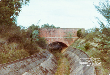
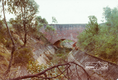 Eltham District Historical Society Inc
Photograph, Parsons Road Bridge over Maroondah Aqueduct near Margaret Street, Eltham, c.Jun 1981, 1981
... Parsons Road Bridge over Maroondah Aqueduct near Margaret... road Colour photograph Parsons Road Bridge over Maroondah ...Colour photographmaroondah aqueduct, bridge, eltham, margaret street, parsons road -
 Eltham District Historical Society Inc
Photograph, Parsons Road Bridge over Maroondah Aqueduct near Margaret Street, Eltham, c.Jun 1981, 1981
... Parsons Road Bridge over Maroondah Aqueduct near Margaret... road Colour photograph Parsons Road Bridge over Maroondah ...Colour photographmaroondah aqueduct, bridge, eltham, margaret street, parsons road