Showing 1938 items
matching floods
-
 Charlton Golden Grains Museum Inc
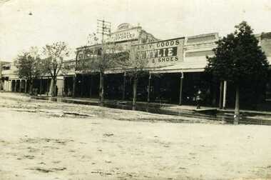
Photograph, Flood 1911, c. 1911
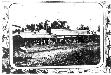
High St Charlton showing W. Wylie General Store, 1911 floodSepia photo of High St Charlton showing W. Wylie General Store and Golden Fleece Hotel after the 1911 flood. Two children standing on footpath with water on the road in front of them.charlton, wylie's building, flood, high street -
 Melbourne Tram Museum
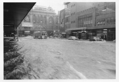
Photograph - Set of 5 black and white - Elizabeth St flood, Peter Duckett, 17-2-1972
... Floods ...Shows the impact of a major rain event near the Victoria Market and the former creek bed of Elizabeth Street acting as a drain. Cars floated and trams were damaged.Yields information about a major rain event in Elizabeth St during 1972 and the impact it had on vehicles and tramway operations.Set of five black and white photographs of major flooding in Elizabeth St 17-2-1972. Copied by the donor from negatives provided by the photographer.floods, elizabeth st, tramways, events, trams, melbourne -
 Greensborough Historical Society
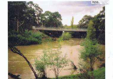
Photograph - Photograph (Copy), Anne Paul, Plenty River in flood 2003, Lower Plenty, 2003_12
... floods ...Two views of Plenty River in flood, Lower Plenty.2 colour photographs printed on paper, handwritten captionslower plenty, plenty river, floods -
 Lakes Entrance Historical Society
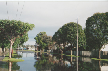
Photograph, Bulmer Street in flood Lakes Entrance Victoria, 2004 c
... Floods ...Colour photograph showing flood water in Bulmer Street looking south towards the Cunninghame Arm Lakes Entrance Victoria. Also second colour photograph taken at same time plus another of a house under construction following a mini tornado in 2005floods, naturalm disasters, township -
 Greensborough Historical Society
Photograph - Digital image, Plenty River in Flood 2017: Graffiti, 14/12/2017
... floods ...Photograph of graffiti on the Plenty River bridge, Greensborough. This flood was in December 2017.Digital copy of colour photograph.plenty river, floods, graffiti -
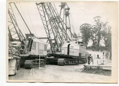 Orbost & District Historical Society
black and white photographs, 1974 - 1976
Construction of the roadway embankment between the bridges across the Snowy River flood plains at Orbost commenced in January 1974 and was completed in November 1976. Pearsons were the bridge contractors for the construction of the Princes Freeway and bridges across the river flood plains at Orbost. Heavy rains and floods held up progress.These photographs are of the construction of a major structure in Orbost. The opening of this Snowy River Bridge was an important development in the accessibility to the township of Orbost.Four black / white photographs of construction sites. 3241.1 is of three cranes and other machinery with six persons. 3241.2 is of workmen working on flooded site. 3241.3 is a photograph of the early stages of construction of a bridge looking towards the township. 3241.4 shows the construction of a roadway between the bridges.construction-snowy-river-bridge bridge-orbost -
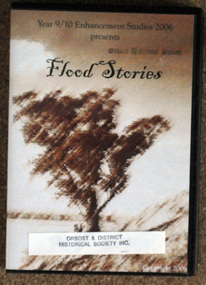 Orbost & District Historical Society
D.V.D, Flood Stories, 2006
In October 2006, Orbost Secondary College 9/10 Enhancement Studies Class worked to preserve the memories of the Orbost community with three short films describing recollections of Orbost floods. There are ten stories including memories of the 1952, 1971 and 1991 floods. They are narrated by various Orbost identities - Anne Bridges; Kay Lynn; Ken Edlington; Margaret Adams; Max Reynols; Shirley Reynolds and Ngaere Donald.Floods have been part of the history of Orbost since settlement. These stories record impressions of local people.A D.V.D. in a black plastic case. On the cover ia a brown sketch of a tree. Above in black print is the title, "Flood Stories" with " Year 9/10 Enhancement Studies 2006 presents" at the top.sticker and stamp - Orbost & District Historical Society -
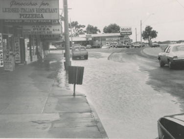 Lakes Entrance Historical Society
Photograph - Flooding of Esplanade Lakes Entrance Victoria 1993, Lakes Post Newspaper, 1/09/1993 12:00:00 AM
Flooding due to inadequate drainage, it soon went down.Black and white photograph showing flooding on Esplanade west of Myers Street intersection, businesses in photograph Pinochio Pizzaria, Lakes Auto Parts, Arjus Pizza, Bait and Tackle and Mobil Service Station on opposite corner Lakes Entrance Victoriabusiness, roads and streets -
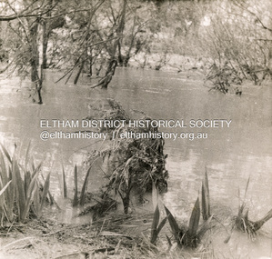 Eltham District Historical Society Inc
Photograph, George W. Bell, Flood Eltham, 1960s
... floods ...Diamond Creek in flood at Eltham c.1960sBlack and white printfloods, eltham, diamond creek, george w bell collection -
 Bialik College
Mixed media (Item) - 2005 General school activity photographs
Colour photographs taken during the Bialik College school year. They depict a range of activities in 2005: bike ride, mali, police band, purim, science Y12, snow sports, flood. Items are listed as being uploaded from 2006 to 2008. Please contact [email protected] to request access to this record.2005 photos bike ride, mali, police band, purim, science Y12, snow sports, flood2000s, 2005, bialik college, sport, science, incursion, excursion, flood -
 Kew Historical Society Inc
Photograph - Flooding of the Yarra River in North Kew, 1934
North Kew, now divided between Kew and Kew East, bordered the Yarra River. As such, it was a region subject to flooding in the Yarra Valley. Development beyond this point (ie Kellett Grove) was limited by the City of Kew's planning regulations. Prior to urban development, the area since European settlement and the first land sales in the district in the 1840s, had been used for dairy farming. Small sepia snapshot of floodwaters taken from near Willsmere Road, in what was then known as North Kew. The point of view is looking towards Fairfield. In the foreground are two figures viewing a group in a rowboat in the middle of the flooded river. Semi-submerged street lighting indicates that entire streets had been. overwhelmed by the flood waters. Verso: WILLSMERE ROAD NORTH KEW / Stamped 3 163yarra river -- north kew, floods -- yarra valley, floods -- north kew, floods -- 1934, natural disasters -- kew, willsmere road -
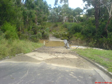 Greensborough Historical Society
Photograph - Digital image, Jasmin Burge, Kalparrin in flood February 2011: group of 5 photographs, 08/02/2011
... floods ...In February 2011, the Plenty River flooded the Kalparrin area in Greensborough. These photographs were taken by GHS member Jasmin Burge.Digital copy of colour photographs.kalparrin reserve, plenty river, floods -
 Eltham District Historical Society Inc
Photograph, Peter Pidgeon, Diamond Creek near Main Road Bridge, Eltham South, 8 Sep. 2021
... floods ...Evidence of flooding from recent winter and early spring rainBorn Digitaleltham south, diamond creek trail, diamond creek (creek), floods -
 Eltham District Historical Society Inc
Photograph, Peter Pidgeon, Diamond Creek near Main Road Bridge, Eltham South, 8 Sep. 2021
... floods ...Evidence of flooding from recent winter and early spring rainBorn Digitaleltham south, diamond creek trail, diamond creek (creek), floods -
 El Dorado Museum Association Inc.
Photograph (item) - Digital Image
... floods ...Cocks Pioneer after Flood. Cocks Pioneer Electric Gold & Tin Mine Company was formed in 1899. The company's first power station, located at the eastern end of the valley began operating with its 340 Kilowatt steam-powered generator. By 1909, from 2,500,000 cubic yards worked, reported recovery was 17,284 ounces of gold and 224 tons of tin ore. By 1909, Cocks Pioneer’s power plant had become inadequate and uneconomical. The barge was floated downstream about a mile, but lost time caused the operations to cease. Following testing, a new mine was established by diverting Reid's Creek at a cost of £25,000. Settling dams were built, one of which held 1,935,900 cubic feet. Sold earth banks, built against a wall of stringy bark saplings constructed and laced with vertical props, were built. In 1914, the company was reformed as Cock’s Pioneer Gold and Tin Mines NL, another power station was constructed at the western end of the township, near the junction of Clear and Reid's Creeks. From 6,800,000 cubic yards of material processed, the returns were 64,397 ounces of gold and 855 ton of tin. Cocks Pioneer mine then moved the barge downs stream and continued sluicing. In 1929 Cocks Pioneer Electric Gold and Tin Mining Company ceased operations due to a drop in values. Cock’s Pioneer Gold and Tin Mines NL carried on large-scale hydraulic sluicing operations until 1941. mining, gold, tin, barge, floods, gold mining, tin mining, cocks pioneer, el dorado, eldorado, men -
 Port Fairy Historical Society Museum and Archives
Photograph
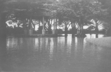
Showing the flood waters of 1946 around the Band Rotunda in the botanical gardens. Funding for the construction of the Rotunda was bequeathed in the Will of local resident Mrs Annie Williams, who was born in Daylesford in 1872 and died in Kew in 1930. Annie’s Will stipulated that the remaining value of her Estate be spent on erecting a Bandstand in the Port Fairy Botanical Gardens dedicated to the memory of her brother Hugh, a stretcher bearer in WW1 and who died in 1921 after being discharged with health issues, her husband Henry, and herself naturally. There is a plaque dedicated to Annie on the Bandstand She requested that the Bandstand be a replica of the one at Daylesford but by 1933 the value of her Estate had diminished to £76.4/8 which was insufficient to cover a similar design and the Borough Councillors felt it would be too extravagant for the Port Fairy Botanical Gardens. Local builder J.J.McLaren’s tender of £71.15/- was accepted and the octagonal concrete pillared construction was completed with the use of sustenance labour the following year. The Bandstand was opened in December, 1934 with a performance by the Port Fairy Band and local residents enjoying the entertainment and a picnic. In 1934 it was reported that there was some fuss in Council because of the whereabouts of the sum of approximately £3/- , being the amount left over from the build. After some months of debate, in which the Councillors suggested that the Engineer had used the money inappropriately, and to which he responded that the build had cost more than the quote, the matter seems to have ended there An image of the flood waters in the botanical gardens in 1946Black and white photograph of Flood water around rotunda in the gardensflood, river, botanical gardens, port fairy, moyne river, rotunda, bandstand -
 Eltham District Historical Society Inc
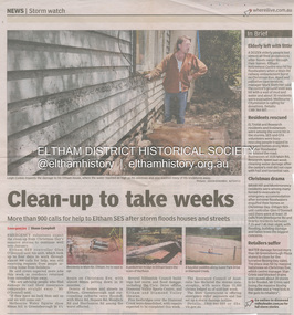
Newsclipping, Shaun Campbell, Clean-up to take weeks, Diamond Valley Leader, December 2011
... floods ...A late afternoon storm on Christmas Day 2011. A flash flood occurred from significant rain fall and hail, which accumulated along an old waterway with floodwater submerging cars along Valonia Drive then down Grove Street flooding houses, through the Bible Street Reserve where it then submerged Main Road washing away the small railway trestle bridge opposite the reserve then flooding the Judge Book Village before finally entering the Diamond Creek. Widespread damage occured from hail and flash flooding.fay bridge collection, eltham, flood damage, floods, floodwater -
 Tarnagulla History Archive
Photograph: Simpsons Store and Hotel, Newbridge after flood, Simpsons Store and Hotel, Newbridge after flood, 1909 (original image)
In this image, store merchandise, including drapery, is hung out to dry after the flood. On 20th August,1909 the Laanecoorie Weir broke away and released 18.3 million cubic metres of water through the opening and causing severe damage to all towns downstream. At Newbridge, Petersen's bakery collapsed and Simpson's Store and Hotel flooded to the roof. The billiard table was later found in a tree five miles down the Loddon near Learmonth. Murray Comrie Collection. Monochrome photograph, image depicting buildings in the area near Loddon River at Newbridge after major flood in 1909. This is a very grainy and dark copy of an older original. Copy probably made by Murray Comrie in the 1960s.newbridge, loddon river, flood, simpson, stores, hotels -
 City of Kingston
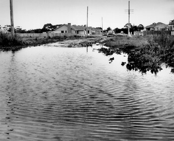
Photograph - Black and white, c. 1958
This photograph depicts flooding of Ozone Avenue in Beaumaris, located off Balcombe Road. Roads in the Beaumaris area lacked sufficient drains to clear surface water. In many cases streets were unsealed and without footpaths and some were dirt tracks. Gutters and road surfaces were made of clay and in the wetter months of winter, unsealed roads and tracks became impossible quagmires that were unnavigable for vehicles and pedestrians. In the first decade after World War II there was rapid expansion in construction of new houses in the suburb of Beaumaris. Utilities and infrastructure to support the growth of housing was inadequate and not provided for prior to the development of the area. Without rudimentary drainage, flooding was frequent. Storm water runoff, domestic sullage and septic tank overflow would form large pools and families were sometimes marooned within their homes. The frequent flooding caused isolation and hardship and residents endured difficulties with accessibility to facilities. These disadvantages had the potential to cause social issues for the new residents.Black and white photograph of flooding in Ozone Avenue, Beaumaris. The image shows floodwaters with boggy and rough terrain on an unsealed road with housing in the distance.Handwritten in blue ink: 2124 circled Handwritten in red ink: 80% Handwritten in blue ink on yellow Post-It note: Chap 6. underlined, 2194 Ozone Ave Beaumaris 1958beaumaris, ozone avenue, balcombe road, flooding, roads, infrastructure -
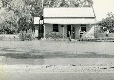 Charlton Golden Grains Museum Inc
Photograph, Charlton Tribune, 1973 February Flood, Feb 1973
Feb 1973 flood Charlton, Victoria. Old Ive's house with floodwater to front fence on the Calder Highway opposite Charlton Park Gates. Mrs Gloria Jordan.B/W Photograph of February 1973 flood. Old Ive's house with floodwater to front fence on Calder Highway opposite Charlton Park gates. Photo used in Charlton Tribune on 09/07/1973 P4.flood, charlton, calder highway, local brick -
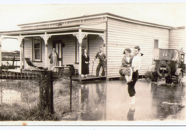 Lakes Entrance Historical Society
Photograph - Rosemont/Fraser, 1935 C
... Floods ...Sepia toned photograph of a man carrying a woman through flood water surrounding Rosemont House, Barkes Avenue. On the veranda of boarding house are Alice Fraser nee Falk, her daughter Joan and husband George leaning on stick, beside house is a soft topped sedan car with sign Telsons on back, Lakes Entrance Victoria.genealogy, guesthouses, floods -
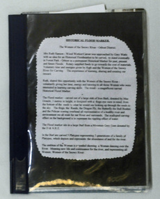 Orbost & District Historical Society
folder, Historical Flood Marker, 1999 - 2001
This folder contains a record of the construction of the flood marker in Forest Park, Orbost. It depicts the six highest floods since the first recording. The construction of the marker was commenced in August 1999 and took eighteen months to be completed by nine volunteers under the tutelage of Ruth Hansen.This item is a contemporary record of the construction of an iconic marker in Orbost.A loose leaf folder containing information, records and photographs about the Historic Flood Marker in Forest Park, Orbost. Most photographs and printed text are glued in. There are twelve loose photographs.The front cover and spine are dark blue, the back is a lighter blue and has a bar code and price sticker attached.flood-marker-orbost -
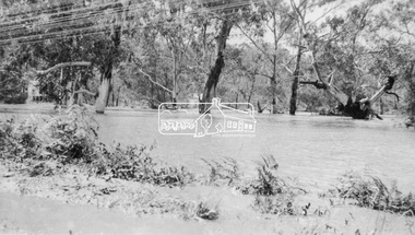
 Eltham District Historical Society Inc
Negative - Photograph, Diamond Creek floodwater at Monash Bridge, Hurstbridge, Dec. 1934
... floods ...The historic 1934 flood of the Diamond Creek and Yarra River following the storms of 29-30 November set the levels for future planning with respect to flood water rise.This photo forms part of a collection of photographs gathered by the Shire of Eltham for their centenary project book,"Pioneers and Painters: 100 years of the Shire of Eltham" by Alan Marshall (1971). The collection of over 500 images is held in partnership between Eltham District Historical Society and Yarra Plenty Regional Library (Eltham Library) and is now formally known as the 'The Shire of Eltham Pioneers Photograph Collection.' It is significant in being the first community sourced collection representing the places and people of the Shire's first one hundred years.Digital image 4 x 5 inch B&W Negshire of eltham pioneers photograph collection, hurstbridge, 1934 flood, floods, monash bridge, diamond creek (creek) -
 Eltham District Historical Society Inc
Negative - Photograph, Floodwaters, Diamond Creek, Eltham, 1934
... floods ...The Diamond Creek in flood near the Main Road bridge at Eltham, Victoria. The Yarra also was in flood. In early December 1934 the "Greatest flood in the history of the Yarra" occured, according to The Argus newspaper. Bridges and houses were swept away with hundreds of people left homeless across the state. The historic 1934 flood of the Diamond Creek and Yarra River set the criteria for future planning with respect to flood water rise. Noted on reverse of print - Copied by Hugh Fisher, 82 Lygon St., BrunswickThis photo forms part of a collection of photographs gathered by the Shire of Eltham for their centenary project book,"Pioneers and Painters: 100 years of the Shire of Eltham" by Alan Marshall (1971). The collection of over 500 images is held in partnership between Eltham District Historical Society and Yarra Plenty Regional Library (Eltham Library) and is now formally known as the 'The Shire of Eltham Pioneers Photograph Collection.' It is significant in being the first community sourced collection representing the places and people of the Shire's first one hundred years.Digital image 4 x 5 inch B&W Neg (2 frames on one neg) Print 9 x 15.5 cmOn reverse of print - "Copied by Hugh Fisher, 82 Lygon St., Brunswick" (for Shire of Eltham)sepp, shire of eltham pioneers photograph collection, eltham, floods, 1934 flood, diamond creek (creek), floodwater -
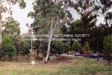
 Eltham District Historical Society Inc
Photograph, Flooding of Diamond Creek at Lower Eltham, Feb 2005, 2005
... floods ...Three colour photographs of the flooded Diamond Creek showing Main Road floodwater below Dalton Street (Eltham Primary) school, west side of Diamond Creek near flower stall and Wingrove Park, Feb 2005eltham, main road, diamond creek, floods, dalton street, wingrove park -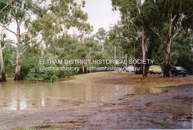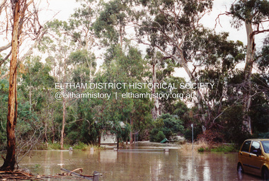
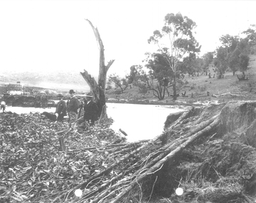
 Warrnambool and District Historical Society Inc.
Footwear - Child's boot, 1940s
This small shoe (or boot) was found at Rosebrook, a small settlement between Warrnambool and Port Fairy, after the 1946 Western District floods. These floods are regarded as the worst in the history of European settlement in the Western District. At least five lives were lost, many small settlements and towns were isolated resulting in food shortages, onion and potato crops were ruined, 20 bridges were destroyed or damaged, roads were swept away, hundreds of farm animals perished and road and rail services were disrupted. The floods were the result of a very high rainfall in five successive days (658 points of rain in one 24 hours) and there was more flooding a week after the first major impact of the rains. A link to a major weather event in the South west.This is a small child’s brown shoe made of leather with a lace-up upper part (no laces) and a leather sole. The sides of the upper part of the shoe have broken away at the edges. As the shoe has been water-logged (it was found after the 1946 Western District floods) it has become hard and brittle. warrnambool, rosebrook western district floods, 1946, 1940's shoe -
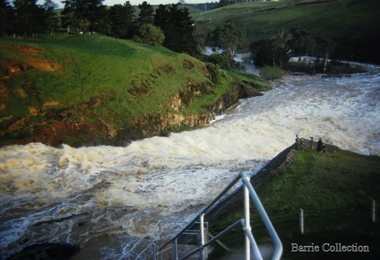
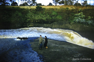 Melton City Libraries
Photograph, Melton Weir, 1961
Family at the spillway in floodmisc. -
 Melton City Libraries
Photograph, Melton Weir, 1961
Family at the spillway in floodmisc.