Showing 423 items matching " map of system"
-
 Kew Historical Society Inc
Plan, Melbourne & Metropolitan Board of Works : Borough of Kew : Detail Plan No.1561, 1905
The Melbourne and Metropolitan Board of Works (MMBW) plans were produced from the 1890s to the 1950s. They were crucial to the design and development of Melbourne's sewerage and drainage system. The plans, at a scale of 40 feet to 1 inch (1:480), provide a detailed historical record of Melbourne streetscapes and environmental features. Each plan covers one or two street blocks (roughly six streets), showing details of buildings, including garden layouts and ownership boundaries, and features such as laneways, drains, bridges, parks, municipal boundaries and other prominent landmarks as they existed at the time each plan was produced. (Source: State Library of Victoria). This plan forms part of a large group of MMBW plans and maps that was donated to the Society by Mr Poulter, City Engineer of the City of Kew in 1989. Within this collection, thirty-five hand-coloured plans, backed with linen, are of statewide significance as they include annotations that provide details of construction materials used in buildings in the first decade of the 20th century as well as additional information about land ownership and usage. The copies in the Public Record Office Victoria and the State Library of Victoria are monochrome versions which do not denote building materials so that the maps in this collection are invaluable and unique tools for researchers and heritage consultants. A number of the plans are not held in the collection of the State Library of Victoria so they have the additional attribute of rarity.Original survey plan, issued by the MMBW to a contractor with responsibility for constructing sewers in the area identified on the plan within the Borough of Kew. The plan was at some stage hand-coloured, possibly by the contractor, but more likely by officers working in the Engineering Department of the Borough and later Town, then City of Kew. The hand-coloured sections of buildings on the plan were used to denote masonry or brick constructions (pink), weatherboard constructions (yellow), and public buildings (grey). MMBW Detail Plan 1561 outlines those residences in the area bordered by Burke Road, Loxton Street, Mount Street and Barkers Road that had been constructed by 1905 when the land was surveyed. At this time, the area nearest Burke Road had been subdivided and developed whereas the lands to the west were as yet undeveloped. The houses represented are not named on the Plan.melbourne and metropolitan board of works, detail plans, mmbw 1561, cartography -
 Kew Historical Society Inc
Plan, Melbourne and Metropolitan Board of Works, Borough of Kew : Detail Plan No.1562, 1905
The Melbourne and Metropolitan Board of Works (MMBW) plans were produced from the 1890s to the 1950s. They were crucial to the design and development of Melbourne's sewerage and drainage system. The plans, at a scale of 40 feet to 1 inch (1:480), provide a detailed historical record of Melbourne streetscapes and environmental features. Each plan covers one or two street blocks (roughly six streets), showing details of buildings, including garden layouts and ownership boundaries, and features such as laneways, drains, bridges, parks, municipal boundaries and other prominent landmarks as they existed at the time each plan was produced. (Source: State Library of Victoria). This plan forms part of a large group of MMBW plans and maps that was donated to the Society by the Mr Poulter, City Engineer of the City of Kew in 1989. Within this collection, thirty-five hand-coloured plans, backed with linen, are of statewide significance as they include annotations that provide details of construction materials used in buildings in the first decade of the 20th century as well as additional information about land ownership and usage. The copies in the Public Record Office Victoria and the State Library of Victoria are monochrome versions which do not denote building materials so that the maps in this collection are invaluable and unique tools for researchers and heritage consultants. A number of the plans are not held in the collection of the State Library of Victoria so they have the additional attribute of rarity.Original survey plan, issued by the MMBW to a contractor with responsibility for constructing sewers in the area identified on the plan within the Borough of Kew. The plan was at some stage hand-coloured, possibly by the contractor, but more likely by officers working in the Engineering Department of the Borough and later Town, then City of Kew. The hand-coloured sections of buildings on the plan were used to denote masonry or brick constructions (pink), weatherboard constructions (yellow), and public buildings (grey). MMBW detail plan No.1562, in contrast to No.1561 includes the names of a large number of houses: in Barkers Road: ‘Ashwick’, ‘Owasso’, ‘Anadiha’, ‘Eurobin’, ‘Carlsruhe’, ‘Arlington’ and ‘Altyre’. Unnamed but clearly represented on the plan is what was then known as the ‘Auburn Heights Recreation Club’, which at this stage included a Bowling Green, a Croquet Green and two Tennis Courts. On the plan, Brougham Place, as it was then known, is represented. It was later renamed Daniell Place. The aforementioned Arlington is now the junior campus of Preshil. melbourne and metropolitan board of works, detail plans, mmbw 1562, cartography -
 Kew Historical Society Inc
Plan, Melbourne & Metropolitan Board of Works : Borough of Kew : Detail Plan No.1563, 1905
The Melbourne and Metropolitan Board of Works (MMBW) plans were produced from the 1890s to the 1950s. They were crucial to the design and development of Melbourne's sewerage and drainage system. The plans, at a scale of 40 feet to 1 inch (1:480), provide a detailed historical record of Melbourne streetscapes and environmental features. Each plan covers one or two street blocks (roughly six streets), showing details of buildings, including garden layouts and ownership boundaries, and features such as laneways, drains, bridges, parks, municipal boundaries and other prominent landmarks as they existed at the time each plan was produced. (Source: State Library of Victoria)This plan forms part of a large group of MMBW plans and maps that was donated to the Society by the Mr Poulter, City Engineer of the City of Kew in 1989. Within this collection, thirty-five hand-coloured plans, backed with linen, are of statewide significance as they include annotations that provide details of construction materials used in buildings in the first decade of the 20th century as well as additional information about land ownership and usage. The copies in the Public Record Office Victoria and the State Library of Victoria are monochrome versions which do not denote building materials so that the maps in this collection are invaluable and unique tools for researchers and heritage consultants. A number of the plans are not held in the collection of the State Library of Victoria so they have the additional attribute of rarity.Original survey plan, issued by the MMBW to a contractor with responsibility for constructing sewers in the area identified on the plan within the Borough of Kew. The plan was at some stage hand-coloured, possibly by the contractor, but more likely by officers working in the Engineering Department of the Borough and later Town, then City of Kew. The hand-coloured sections of buildings on the plan were used to denote masonry or brick constructions (pink), weatherboard constructions (yellow), and public buildings (grey). This plan covers the area between Barkers Road, Wrixon Street, Sackville Street and Brougham Place, much of it now occupied by Carey Baptist Grammar and Preshil schools. This was an area of large and prestigious homes in 1903, some with formally laid-out gardens, such as ‘Tower Hill’ and ‘Opawa’. ‘Kalimna’ was built in 1890-91 for William H. Jarman, an accountant, and ‘Blackhall’ at the same time for W.H. Roberts. Blackhall was to be acquired by the Salvation Army in 1915 and renamed ‘Catherine Booth Girls’ Home’. The Home accommodated girls, aged between 4 and 16. Kalimna and Blackhall are of significance as typical and intact late Victorian mansions and as such are two key Victorian buildings to have been built in Kew. Both Blackhall and Kalimna are now part of Preshil. ‘Fairview’ was for a long time occupied by the Sisters of St. Joseph of Cluny as a care home for the elderly, but it is now part of Carey Grammar School, as are the grounds of ‘Wagga Merne’, ‘Weemutta’, ‘Blakely’, ‘Daheim’ and ‘Mildura’ (later ‘Urangeline’), the last being particularly impressive in 1903, with a tennis court, conservatory, outhouses, and two bathrooms!melbourne and metropolitan board of works, detail plans, mmbw 1563, cartography -
 Kew Historical Society Inc
Plan, Melbourne & Metropolitan Board of Works : Borough of Kew : Detail Plan No.1564, 1905
The Melbourne and Metropolitan Board of Works (MMBW) plans were produced from the 1890s to the 1950s. They were crucial to the design and development of Melbourne's sewerage and drainage system. The plans, at a scale of 40 feet to 1 inch (1:480), provide a detailed historical record of Melbourne streetscapes and environmental features. Each plan covers one or two street blocks (roughly six streets), showing details of buildings, including garden layouts and ownership boundaries, and features such as laneways, drains, bridges, parks, municipal boundaries and other prominent landmarks as they existed at the time each plan was produced. (Source: State Library of Victoria)This plan forms part of a large group of MMBW plans and maps that was donated to the Society by the Mr Poulter, City Engineer of the City of Kew in 1989. Within this collection, thirty-five hand-coloured plans, backed with linen, are of statewide significance as they include annotations that provide details of construction materials used in buildings in the first decade of the 20th century as well as additional information about land ownership and usage. The copies in the Public Record Office Victoria and the State Library of Victoria are monochrome versions which do not denote building materials so that the maps in this collection are invaluable and unique tools for researchers and heritage consultants. A number of the plans are not held in the collection of the State Library of Victoria so they have the additional attribute of rarity.Original survey plan, issued by the MMBW to a contractor with responsibility for constructing sewers in the area identified on the plan within the Borough of Kew. The plan was at some stage hand-coloured, possibly by the contractor, but more likely by officers working in the Engineering Department of the Borough and later Town, then City of Kew. The hand-coloured sections of buildings on the plan were used to denote masonry or brick constructions (pink), weatherboard constructions (yellow), and public buildings (grey). In 1905, when Plan No.1564 was printed, that part of Kew bordered by Brougham Place (now Daniell Place), Mount Street, Sackville Street and Ross Street was already the location of a number of large mansions. Here, subdivisions, at least at this stage, produced larger blocks than in Central Kew. Many of the houses on this plan are named: ‘Faybrook’, ‘Northumbria’, ‘Parkholm[e]’, ‘Dunboe’, ‘Katoomba’ and ‘Eschol’ fronting Sackville Street. Eschol was once the home of the manufacturer Robert Harrison, whose cordial factory in Spring and Argyle Streets Fitzroy are noted on the Victorian Heritage Register. ‘The Hawthorns’ on the corner of Brougham Place and Mount Street was the home of the medical practitioner Frank William Fay, who won the military cross and other honours for conspicuous gallantry and devotion to duty in World War 1.melbourne and metropolitan board of works, detail plans, mmbw 1564, cartography -
 Kew Historical Society Inc
Plan, Melbourne & Metropolitan Board of Works : Borough of Kew : Detail Plan No.1565, 1905
The Melbourne and Metropolitan Board of Works (MMBW) plans were produced from the 1890s to the 1950s. They were crucial to the design and development of Melbourne's sewerage and drainage system. The plans, at a scale of 40 feet to 1 inch (1:480), provide a detailed historical record of Melbourne streetscapes and environmental features. Each plan covers one or two street blocks (roughly six streets), showing details of buildings, including garden layouts and ownership boundaries, and features such as laneways, drains, bridges, parks, municipal boundaries and other prominent landmarks as they existed at the time each plan was produced. (Source: State Library of Victoria). This plan forms part of a large group of MMBW plans and maps that was donated to the Society by the Mr Poulter, City Engineer of the City of Kew in 1989. Within this collection, thirty-five hand-coloured plans, backed with linen, are of statewide significance as they include annotations that provide details of construction materials used in buildings in the first decade of the 20th century as well as additional information about land ownership and usage. The copies in the Public Record Office Victoria and the State Library of Victoria are monochrome versions which do not denote building materials so that the maps in this collection are invaluable and unique tools for researchers and heritage consultants. A number of the plans are not held in the collection of the State Library of Victoria so they have the additional attribute of rarity.Original survey plan, issued by the MMBW to a contractor with responsibility for constructing sewers in the area identified on the plan within the Borough of Kew. The plan was at some stage hand-coloured, possibly by the contractor, but more likely by officers working in the Engineering Department of the Borough and later Town, then City of Kew. The hand-coloured sections of buildings on the plan were used to denote masonry or brick constructions (pink), weatherboard constructions (yellow), and public buildings (grey). MMBW Plan No.1565 is an example of a plan where a number of streets have been created since the area was surveyed, or in other cases renamed. The plan shows those streets that were bordered by Ross Street, Mount Street, Sackville Street and Burke Road. Since 1905, Mawson Street has been created and Mont Albert Road renamed as Dean Street. Named houses on the plan include ‘Tyrol’, ‘Glengorse’, ‘Theodore Villa’, ‘Arncliffe’, ‘Ballynira’ and ‘Hazeldene’. The plan also shows a Wesleyan Church in Sackville Street. In 1883, the Church’s Sunday School celebrated its silver anniversary.melbourne and metropolitan board of works, detail plans, mmbw 1565, cartography -
 Kew Historical Society Inc
Plan, Melbourne & Metropolitan Board of Works : Borough of Kew : Detail Plan No.1568, 1905
The Melbourne and Metropolitan Board of Works (MMBW) plans were produced from the 1890s to the 1950s. They were crucial to the design and development of Melbourne's sewerage and drainage system. The plans, at a scale of 40 feet to 1 inch (1:480), provide a detailed historical record of Melbourne streetscapes and environmental features. Each plan covers one or two street blocks (roughly six streets), showing details of buildings, including garden layouts and ownership boundaries, and features such as laneways, drains, bridges, parks, municipal boundaries and other prominent landmarks as they existed at the time each plan was produced. (Source: State Library of Victoria)This plan forms part of a large group of MMBW plans and maps that was donated to the Society by the Mr Poulter, City Engineer of the City of Kew in 1989. Within this collection, thirty-five hand-coloured plans, backed with linen, are of statewide significance as they include annotations that provide details of construction materials used in buildings in the first decade of the 20th century as well as additional information about land ownership and usage. The copies in the Public Record Office Victoria and the State Library of Victoria are monochrome versions which do not denote building materials so that the maps in this collection are invaluable and unique tools for researchers and heritage consultants. A number of the plans are not held in the collection of the State Library of Victoria so they have the additional attribute of rarity.Original survey plan, issued by the MMBW to a contractor with responsibility for constructing sewers in the area identified on the plan within the Borough of Kew. The plan was at some stage hand-coloured, possibly by the contractor, but more likely by officers working in the Engineering Department of the Borough and later Town, then City of Kew. The hand-coloured sections of buildings on the plan were used to denote masonry or brick constructions (pink), weatherboard constructions (yellow), and public buildings (grey). Plan No.1568 covers the area bounded by Cotham Road, John Street, Sackville Street, and Edward Street. Alfred Street and Rowland Street are in shown in the middle of the plan. The two most notable buildings shown are ‘St Helliers’, the home of the Dumaresq family, and St Hilary’s Church and school. While the colours used to indicate St Hilary’s are grey as in other civic/public buildings, the first St Hilary’s Anglican Church was at this stage constructed in weatherboard. At the left of the plan, facing Sackville Street is a house named ‘Glencara’. The 1988 ‘Kew Conservation Study’ recorded that “The first documentary evidence of this house comes from Rate Books which record that in 1893 a Mrs Treadway was the owner of this building with an N.A.V. of £81? At that date the occupier of the house was Charles B. Kelly, a clerk, while by 1910 Kelly had become the owner of the property described in that year ‘as a six-roomed stone, brick and wood house with stables and outbuildings’”. Contrary to this description, the 1905 plan indicates that the house was entirely constructed of masonry.melbourne and metropolitan board of works, detail plans, mmbw 1568 -
 Kew Historical Society Inc
Plan, Melbourne & Metropolitan Board of Works : Borough of Kew : Detail Plan No.1569, 1905
The Melbourne and Metropolitan Board of Works (MMBW) plans were produced from the 1890s to the 1950s. They were crucial to the design and development of Melbourne's sewerage and drainage system. The plans, at a scale of 40 feet to 1 inch (1:480), provide a detailed historical record of Melbourne streetscapes and environmental features. Each plan covers one or two street blocks (roughly six streets), showing details of buildings, including garden layouts and ownership boundaries, and features such as laneways, drains, bridges, parks, municipal boundaries and other prominent landmarks as they existed at the time each plan was produced. (Source: State Library of Victoria)This plan forms part of a large group of MMBW plans and maps that was donated to the Society by the Mr Poulter, City Engineer of the City of Kew in 1989. Within this collection, thirty-five hand-coloured plans, backed with linen, are of statewide significance as they include annotations that provide details of construction materials used in buildings in the first decade of the 20th century as well as additional information about land ownership and usage. The copies in the Public Record Office Victoria and the State Library of Victoria are monochrome versions which do not denote building materials so that the maps in this collection are invaluable and unique tools for researchers and heritage consultants. A number of the plans are not held in the collection of the State Library of Victoria so they have the additional attribute of rarity.Original survey plan, issued by the MMBW to a contractor with responsibility for constructing sewers in the area identified on the plan within the Borough of Kew. The plan was at some stage hand-coloured, possibly by the contractor, but more likely by officers working in the Engineering Department of the Borough and later Town, then City of Kew. The hand-coloured sections of buildings on the plan were used to denote masonry or brick constructions (pink), weatherboard constructions (yellow), and public buildings (grey). This plan covers parts of Sackville Street, John Street, Thomas Street and Cotham Road, and includes several very large houses in Sackville Street. Job Smith built ‘Berrington’ in about 1888-90 for himself, and ‘Pomeroy’ (now ‘Merridale’) in 1885 for James Mickleburgh. ‘Heathfield’ was built in 1888 for Henry Eeles, and was one of many fine homes in Kew, Hawthorn and surrounding suburbs designed by prolific architect John Beswicke; it later became “La Verna” and was a Franciscan monastery. Similarly, in Cotham Road, we can see ‘Bella Vista’ (now demolished), and ‘Charleville’, with its double-storeyed arcade frontage, built in 1889 for Charles Donaldson whose family occupied it until 1939. This was renamed ‘Ross House’ by the second owner, Dr. Thomas King, and then substantially restored in the 1960s by the Stillwell family, well known as car drivers and dealers. Bella Vista (later ‘Malinda’) was originally designed by the architect Robert Haddon and built for Abel Hoadley, inventor of the Violet Crumble Bar and many other delicious delicacies. He began by manufacturing jams and pickles in South Melbourne using fruit from his own orchard in East Burwood.melbourne and metropolitan board of works, detail plans, mmbw 1569, cartography -
 Kew Historical Society Inc
Plan, Melbourne & Metropolitan Board of Works : Borough of Kew : Detail Plan No.1570, 1905
The Melbourne and Metropolitan Board of Works (MMBW) plans were produced from the 1890s to the 1950s. They were crucial to the design and development of Melbourne's sewerage and drainage system. The plans, at a scale of 40 feet to 1 inch (1:480), provide a detailed historical record of Melbourne streetscapes and environmental features. Each plan covers one or two street blocks (roughly six streets), showing details of buildings, including garden layouts and ownership boundaries, and features such as laneways, drains, bridges, parks, municipal boundaries and other prominent landmarks as they existed at the time each plan was produced. (Source: State Library of Victoria)This plan forms part of a large group of MMBW plans and maps that was donated to the Society by the Mr Poulter, City Engineer of the City of Kew in 1989. Within this collection, thirty-five hand-coloured plans, backed with linen, are of statewide significance as they include annotations that provide details of construction materials used in buildings in the first decade of the 20th century as well as additional information about land ownership and usage. The copies in the Public Record Office Victoria and the State Library of Victoria are monochrome versions which do not denote building materials so that the maps in this collection are invaluable and unique tools for researchers and heritage consultants. A number of the plans are not held in the collection of the State Library of Victoria so they have the additional attribute of rarity.Original survey plan, issued by the MMBW to a contractor with responsibility for constructing sewers in the area identified on the plan within the Borough of Kew. The plan was at some stage hand-coloured, possibly by the contractor, but more likely by officers working in the Engineering Department of the Borough and later Town, then City of Kew. The hand-coloured sections of buildings on the plan were used to denote masonry or brick constructions (pink), weatherboard constructions (yellow), and public buildings (grey). Plan No.1570 shows the layout of gardens and houses in Sackville Street, Davis Street, Wrixon Street, and Fitzwilliam Street in 1904. While Thomas Street is included on the map, at this stage no houses had been built. The plan identifies two named houses: ‘Fairview’ and ‘Kylemore’. Fairview is more fully delineated in Plan No.1563. Kylemore is one of the few houses in Kew designed by John Beswicke. The most notable owner of Kylemore was William Whitehead, who owned the house between 1895 and 1900. In 1894, Australian newspapers reported the marriage of Whitehead’s daughter to Dr. Gerald Eugene Cussen, the brother of Sir Leo Cussen, the Supreme Court Judge. The married couple was to live at ‘Wilton’ (now the Kew RSL) from 1911-15.melbourne and metropolitan board of works, detail plans, mmbw 1570, cartography -
 Kew Historical Society Inc
Plan, Melbourne & Metropolitan Board of Works : Borough of Kew : Detail Plan No.1571, 1904
The Melbourne and Metropolitan Board of Works (MMBW) plans were produced from the 1890s to the 1950s. They were crucial to the design and development of Melbourne's sewerage and drainage system. The plans, at a scale of 40 feet to 1 inch (1:480), provide a detailed historical record of Melbourne streetscapes and environmental features. Each plan covers one or two street blocks (roughly six streets), showing details of buildings, including garden layouts and ownership boundaries, and features such as laneways, drains, bridges, parks, municipal boundaries and other prominent landmarks as they existed at the time each plan was produced. (Source: State Library of Victoria)This plan forms part of a large group of MMBW plans and maps that was donated to the Society by the Mr Poulter, City Engineer of the City of Kew in 1989. Within this collection, thirty-five hand-coloured plans, backed with linen, are of statewide significance as they include annotations that provide details of construction materials used in buildings in the first decade of the 20th century as well as additional information about land ownership and usage. The copies in the Public Record Office Victoria and the State Library of Victoria are monochrome versions which do not denote building materials so that the maps in this collection are invaluable and unique tools for researchers and heritage consultants. A number of the plans are not held in the collection of the State Library of Victoria so they have the additional attribute of rarity.Digital copy of the original survey plan, issued by the MMBW to a contractor with responsibility for constructing sewers in the area identified on the plan within the Borough of Kew. The plan was at some stage hand-coloured, possibly by the contractor, but more likely by officers working in the Engineering Department of the Borough and later Town, then City of Kew. The hand-coloured sections of buildings on the plan were used to denote masonry or brick constructions (pink), weatherboard constructions (yellow), and public buildings (grey). This plan is part of a large and historically significant group of MMBW plans and maps that was donated to the Society by the Mr Poulter, City Engineer of the City of Kew in 1989. When the contracts were let for surveyors to identify and record the extant houses and landscapes within an area for the Board of Works, the contracts were let at separate times, hence the anomaly where two copies of Plan No.1571 exist in our collection. The first of these plans identifies the building materials used in houses bordering Fitzwilliam Street, Edgevale Road, May Street, Malin Street, Davis Street and Wellington Street. The cut off point for the survey was the south side of Wellington Street. By 1903 when the survey was undertaken many of the sites were already built on, particularly those facing Edgevale Road. The plan identifies the preponderance of weatherboard houses in the area. The other version of the plan identifies the buildings between Wellington Street and Cotham Road.melbourne and metropolitan board of works, detail plans, mmbw 1571, cartography -
 Kew Historical Society Inc
Plan, Melbourne & Metropolitan Board of Works : Borough of Kew : Detail Plan No.1571, 1904
The Melbourne and Metropolitan Board of Works (MMBW) plans were produced from the 1890s to the 1950s. They were crucial to the design and development of Melbourne's sewerage and drainage system. The plans, at a scale of 40 feet to 1 inch (1:480), provide a detailed historical record of Melbourne streetscapes and environmental features. Each plan covers one or two street blocks (roughly six streets), showing details of buildings, including garden layouts and ownership boundaries, and features such as laneways, drains, bridges, parks, municipal boundaries and other prominent landmarks as they existed at the time each plan was produced. (Source: State Library of Victoria)This plan forms part of a large group of MMBW plans and maps that was donated to the Society by the Mr Poulter, City Engineer of the City of Kew in 1989. Within this collection, thirty-five hand-coloured plans, backed with linen, are of statewide significance as they include annotations that provide details of construction materials used in buildings in the first decade of the 20th century as well as additional information about land ownership and usage. The copies in the Public Record Office Victoria and the State Library of Victoria are monochrome versions which do not denote building materials so that the maps in this collection are invaluable and unique tools for researchers and heritage consultants. A number of the plans are not held in the collection of the State Library of Victoria so they have the additional attribute of rarity.Original survey plan, issued by the MMBW to a contractor with responsibility for constructing sewers in the area identified on the plan within the Borough of Kew. The plan was at some stage hand-coloured, possibly by the contractor, but more likely by officers working in the Engineering Department of the Borough and later Town, then City of Kew. The hand-coloured sections of buildings on the plan were used to denote masonry or brick constructions (pink), weatherboard constructions (yellow), and public buildings (grey). This plan is the other half of Plan No.1571 representing the constructions to the west of Wellington Street before and in 1903/4. This plan represents the built environment in Edgevale Road, Wellington Street, Atkins Street, Annadale Street, Mortimer Street, and Cotham Road. Whereas there are smaller allotments and more modest housing stock facing Edgevale Road, larger blocks and more substantial houses are represented facing Cotham Road.melbourne and metropolitan board of works, detail plans, mmbw 1571, cartography -
 Kew Historical Society Inc
Plan, Melbourne & Metropolitan Board of Works : Borough of Kew : Detail Plan No.1572, 1905
The Melbourne and Metropolitan Board of Works (MMBW) plans were produced from the 1890s to the 1950s. They were crucial to the design and development of Melbourne's sewerage and drainage system. The plans, at a scale of 40 feet to 1 inch (1:480), provide a detailed historical record of Melbourne streetscapes and environmental features. Each plan covers one or two street blocks (roughly six streets), showing details of buildings, including garden layouts and ownership boundaries, and features such as laneways, drains, bridges, parks, municipal boundaries and other prominent landmarks as they existed at the time each plan was produced. (Source: State Library of Victoria)This plan forms part of a large group of MMBW plans and maps that was donated to the Society by the Mr Poulter, City Engineer of the City of Kew in 1989. Within this collection, thirty-five hand-coloured plans, backed with linen, are of statewide significance as they include annotations that provide details of construction materials used in buildings in the first decade of the 20th century as well as additional information about land ownership and usage. The copies in the Public Record Office Victoria and the State Library of Victoria are monochrome versions which do not denote building materials so that the maps in this collection are invaluable and unique tools for researchers and heritage consultants. A number of the plans are not held in the collection of the State Library of Victoria so they have the additional attribute of rarity.Original survey plan, issued by the MMBW to a contractor with responsibility for constructing sewers in the area identified on the plan within the Borough of Kew. The plan was at some stage hand-coloured, possibly by the contractor, but more likely by officers working in the Engineering Department of the Borough and later Town, then City of Kew. The hand-coloured sections of buildings on the plan were used to denote masonry or brick constructions (pink), weatherboard constructions (yellow), and public buildings (grey). Plan No. 1572 represents the built environment bordered by Barkers Road, Wrixon Street, Edgevale Road and Fitzwilliam Street. Other streets identified on the plan include Stansell Street. Plan 1572 shows that by 1903-05, there was only patchy development in this area of Kew, mainly on Edgevale Road and Fitzwilliam Street. Only two named houses are identified: the quaintly named ‘Tweed Cottage’, and ‘Mendip’. The earliest reference to Treed Cottage in Australian newspapers is to the death of Walter Thompson, aged 74 who was a resident there in 1885. His youngest daughter was to die there in 1908. Mendip to the north of Tweed Cottage was owned by Henry Thompson; he was to die in 1901; his wife in 1932. At this period of time, Malin Street and Clivedon Court did not extend to Barkers Road.melbourne and metropolitan board of works, detail plans, mmbw 1572, cartography -
 Kew Historical Society Inc
Plan, Melbourne & Metropolitan Board of Works : Borough of Kew : Detail Plan No.1573, 1905
The Melbourne and Metropolitan Board of Works (MMBW) plans were produced from the 1890s to the 1950s. They were crucial to the design and development of Melbourne's sewerage and drainage system. The plans, at a scale of 40 feet to 1 inch (1:480), provide a detailed historical record of Melbourne streetscapes and environmental features. Each plan covers one or two street blocks (roughly six streets), showing details of buildings, including garden layouts and ownership boundaries, and features such as laneways, drains, bridges, parks, municipal boundaries and other prominent landmarks as they existed at the time each plan was produced. (Source: State Library of Victoria)This plan forms part of a large group of MMBW plans and maps that was donated to the Society by the Mr Poulter, City Engineer of the City of Kew in 1989. Within this collection, thirty-five hand-coloured plans, backed with linen, are of statewide significance as they include annotations that provide details of construction materials used in buildings in the first decade of the 20th century as well as additional information about land ownership and usage. The copies in the Public Record Office Victoria and the State Library of Victoria are monochrome versions which do not denote building materials so that the maps in this collection are invaluable and unique tools for researchers and heritage consultants. A number of the plans are not held in the collection of the State Library of Victoria so they have the additional attribute of rarity.Original survey plan, issued by the MMBW to a contractor with responsibility for constructing sewers in the area identified on the plan within the Borough of Kew. The plan was at some stage hand-coloured, possibly by the contractor, but more likely by officers working in the Engineering Department of the Borough and later Town, then City of Kew. The hand-coloured sections of buildings on the plan were used to denote masonry or brick constructions (pink), weatherboard constructions (yellow), and public buildings (grey). This plan has detailed annotations written in red or blue ink, showing prices, which may be the annual valuations of the properties, and some owners’ names, a most unusual feature on contractor's maps. Some areas, such as the buildings of Methodist Ladies’ College (MLC), include the school’s tennis court and swimming pool, but are not coloured to show building materials – did the draftsman just run out of time, or ink, or enthusiasm, before his plan had to be submitted? MLC had been founded in 1882 as a ‘modern school of the first order’ with buildings that formed ‘a collegiate institution for girls unsurpassed in the colonies’. The goal of its founders was to provide a high-class Christian education for girls, comparable with that provided elsewhere for boys. Some shops are shown along Edgevale Road, though they are not designated as commercial premises. Larger houses are depicted, including ‘Fairlawn’ in Barkers Road, and ‘Clevedon’ and ‘Rosehill’ (now demolished) in Fitzwilliam Street.melbourne and metropolitan board of works, detail plans, mmbw 1573, maps - borough of kew, cartography -
 Kew Historical Society Inc
Plan, Melbourne & Metropolitan Board of Works : Borough of Kew : Detail Plan No.1574, 1905
The Melbourne and Metropolitan Board of Works (MMBW) plans were produced from the 1890s to the 1950s. They were crucial to the design and development of Melbourne's sewerage and drainage system. The plans, at a scale of 40 feet to 1 inch (1:480), provide a detailed historical record of Melbourne streetscapes and environmental features. Each plan covers one or two street blocks (roughly six streets), showing details of buildings, including garden layouts and ownership boundaries, and features such as laneways, drains, bridges, parks, municipal boundaries and other prominent landmarks as they existed at the time each plan was produced. (Source: State Library of Victoria)This plan forms part of a large group of MMBW plans and maps that was donated to the Society by the Mr Poulter, City Engineer of the City of Kew in 1989. Within this collection, thirty-five hand-coloured plans, backed with linen, are of statewide significance as they include annotations that provide details of construction materials used in buildings in the first decade of the 20th century as well as additional information about land ownership and usage. The copies in the Public Record Office Victoria and the State Library of Victoria are monochrome versions which do not denote building materials so that the maps in this collection are invaluable and unique tools for researchers and heritage consultants. A number of the plans are not held in the collection of the State Library of Victoria so they have the additional attribute of rarity.Original survey plan, issued by the MMBW to a contractor with responsibility for constructing sewers in the area identified on the plan within the Borough of Kew. The plan was at some stage hand-coloured, possibly by the contractor, but more likely by officers working in the Engineering Department of the Borough and later Town, then City of Kew. The hand-coloured sections of buildings on the plan were used to denote masonry or brick constructions (pink), weatherboard constructions (yellow), and public buildings (grey). This plan shows several very large houses, particularly along Glenferrie Road, and the area now occupied by Ruyton Girls’ School. ‘Tarring’ (incorrectly spelled here as ‘Karring’) was built for Henry Henty in 1872, on part of his original allotment of 20 acres, and ‘Mount View’, which retains its original building and the fountain in the front garden, is part of Ruyton’s Junior School. The most significant change to Tarring and its grounds since 1903, involve the removal of a number of the outbuildings, including a Burmese temple, bought by Henty from the Burmese Exhibit at the Great Exhibition of 1880. It is shown on the plan as a summerhouse. The two-storey mansion, on the corner of Glenferrie Road and Wellington Street, was built in 1891 by leading architect Alfred White as his own home. Having an initial N.A.V. of £160, the house was purchased by a warehouseman Henry Lister, by 1900, when the N.A.V. was recorded at £111. By the turn of the century the house was known as ‘Comaques’. By contrast, much smaller houses are shown in Scott and Byron Streets, including a tiny Mission Hall in Byron Street, which belonged to the Anglican Church from at least 1903 to 1917.melbourne and metropolitan board of works, detail plans, maps - borough of kew, mmbw 1574, cartography -
 Kew Historical Society Inc
Plan, Melbourne & Metropolitan Board of Works : Borough of Kew : Detail Plan No.1575, 1905
The Melbourne and Metropolitan Board of Works (MMBW) plans were produced from the 1890s to the 1950s. They were crucial to the design and development of Melbourne's sewerage and drainage system. The plans, at a scale of 40 feet to 1 inch (1:480), provide a detailed historical record of Melbourne streetscapes and environmental features. Each plan covers one or two street blocks (roughly six streets), showing details of buildings, including garden layouts and ownership boundaries, and features such as laneways, drains, bridges, parks, municipal boundaries and other prominent landmarks as they existed at the time each plan was produced. (Source: State Library of Victoria)This plan forms part of a large group of MMBW plans and maps that was donated to the Society by the Mr Poulter, City Engineer of the City of Kew in 1989. Within this collection, thirty-five hand-coloured plans, backed with linen, are of statewide significance as they include annotations that provide details of construction materials used in buildings in the first decade of the 20th century as well as additional information about land ownership and usage. The copies in the Public Record Office Victoria and the State Library of Victoria are monochrome versions which do not denote building materials so that the maps in this collection are invaluable and unique tools for researchers and heritage consultants. A number of the plans are not held in the collection of the State Library of Victoria so they have the additional attribute of rarity.Original survey plan, issued by the MMBW to a contractor with responsibility for constructing sewers in the area identified on the plan within the Borough of Kew. The plan was at some stage hand-coloured, possibly by the contractor, but more likely by officers working in the Engineering Department of the Borough and later Town, then City of Kew. The hand-coloured sections of buildings on the plan were used to denote masonry or brick constructions (pink), weatherboard constructions (yellow), and public buildings (grey). Plan No.1575 shows that in the area bounded by Wellington Street, Edgevale Road, Glenferrie Road, and Cotham Road, there had already been significant subdivision of land and houses constructed. As one of the highest points in Kew, as expected, there were already some significant mansions built on large allotments of land. Many of these mansions are identified by name on the plan such as ‘Kelso’, ‘Abbotsford’, ‘Clarendon’ and ‘Ashlyn’ in Cotham Road. Other houses of equal size are unnamed on the plan.melbourne and metropolitan board of works, detail plans, maps - borough of kew, mmbw 1575, cartography -
 Kew Historical Society Inc
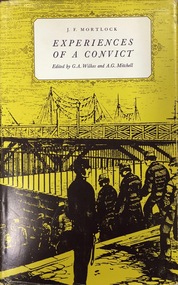
Book, Sydney University Press, Experiences of a Convict: Transported for 21 years, 1968
Originally published in 1864-5. 'Mortlock was sentenced in 1843 for a violent attack on a Fellow of Christ's Church, Cambridge. Transported to NSW, he experienced almost every aspect of the penal system between 1844-1864.Sydney : Sydney University Press, 1965 248 paegs ; 24 cm non-fictionOriginally published in 1864-5. 'Mortlock was sentenced in 1843 for a violent attack on a Fellow of Christ's Church, Cambridge. Transported to NSW, he experienced almost every aspect of the penal system between 1844-1864.transportation, convicts -
 Kew Historical Society Inc
Map, MMBW, MMBW Town of Kew, 1910-21
The Melbourne and Metropolitan Board of Works (MMBW) was established by an act of the Victorian Parliament in 1890 to prepare for and to implement a sewerage and water reticulation system across what was then inner Melbourne, its surrounding and middle distance suburbs, including Kew. The MMBW was disbanded in 1991.The map collection of the Kew Historical Society has at its core the historic maps assembled and originally stored in the City Engineer's Department of the City of Kew. These include maps in a number of scales. The vast majority of maps were produced by the MMBW in the first two decades of the twentieth century, and are solid working maps, backed by linen for durability. These maps are historically significant to Kew, the City of Boroondara and to the history of the development of state utilities in Victoria. A number of the Kew maps have additional details added by former municipal officers, including the levels reached by various floods. As these were working documents, information was added to them long after the period of their initial production and distribution.Early map of the Town of Kew, created after 1910, at a scale 440 ft to 1 inch. The 'assembled' map by the City of Kew Engineer's Department includes scaled down copies of The Melbourne and Metropolitan Board of Works maps, Nos. 39, 40, 64, 65, 66, 67, 68, and 117. The map covers the entirety of the Town of Kew, bordered on its north and west by the River Yarra, by Burke Road in the East and Barkers Road in the south. The map shows the extent of urban development by that time, prominent institutions and the outlines of built structures in the municipality. TOWN OF KEW / SCALE 400 FEET TO 1 INCHmelbourne & metropolitan board of works, mmbw maps, mmbw plans, town of kew, cartography -
 Kew Historical Society Inc
Map, MMBW, MMBW Plan No.39 Kew & Heidelberg, 1900-1910
The Melbourne and Metropolitan Board of Works (MMBW) was established by an act of the Victorian Parliament in 1890 to prepare for and to implement a sewerage and water reticulation system across what was then inner Melbourne, its surrounding and middle distance suburbs, including Kew. The MMBW was disbanded in 1991.The map collection of the Kew Historical Society has at its core the historic maps assembled and originally stored in the City Engineer's Department of the City of Kew. These include maps in a number of scales. The vast majority of maps were produced by the MMBW in the first two decades of the twentieth century, and are solid working maps, backed by linen for durability. These maps are historically significant to Kew, the City of Boroondara and to the history of the development of state utilities in Victoria. A number of the Kew maps have additional details added by former municipal officers, including the levels reached by various floods. As these were working documents, information was added to them long after the period of their initial production and distribution.Early map of part of the Borough of Kew, created in the first decade of the twentieth century, at a scale 160 ft to 1 inch. The map covers what was then the north western section of Kew, bordered on its north by Wills Street and the Kew Lunatic Asylum, in the west by the River Yarra [and the later added Yarra Boulevard] , by Princess Street in the East and Holroyd Street in the south. The map shows the extent of urban development by that time, prominent institutions and the outlines of built structures in the municipality. Contour lines were added in ink to the map at a later stage.MELBOURNE AND METROPOLITAN BOARD OF WORKS / PLAN NO. 39 / KEW & HEIDELBERGmelbourne & metropolitan board of works, mmbw maps, mmbw plans, borough of kew, cartography -
 Kew Historical Society Inc
Map, MMBW, MMBW Plan No.40 Collingwood & Kew, 1900-1910
The Melbourne and Metropolitan Board of Works (MMBW) was established by an act of the Victorian Parliament in 1890 to prepare for and to implement a sewerage and water reticulation system across what was then inner Melbourne, its surrounding and middle distance suburbs, including Kew. The MMBW was disbanded in 1991.The map collection of the Kew Historical Society has at its core the historic maps assembled and originally stored in the City Engineer's Department of the City of Kew. These include maps in a number of scales. The vast majority of maps were produced by the MMBW in the first two decades of the twentieth century, and are solid working maps, backed by linen for durability. These maps are historically significant to Kew, the City of Boroondara and to the history of the development of state utilities in Victoria. A number of the Kew maps have additional details added by former municipal officers, including the levels reached by various floods. As these were working documents, information was added to them long after the period of their initial production and distribution.Early map of part of the Borough of Kew, created in the first decade of the twentieth century, at a scale 160 ft to 1 inch. The map covers what was then the south western section of Kew, bordered on its north by Studley Park Road, in the west by Walmer Street and the River Yarra, by High Street South and Princess Street in the East and Barkers Road in the south. The map shows the extent of urban development by that time, prominent institutions and the outlines of built structures in the municipality. Contour lines and historic flood levels were added in ink to the map at a later stage.MELBOURNE AND METROPOLITAN BOARD OF WORKS / PLAN NO. 40 / COLLINGWOOD & KEWmelbourne & metropolitan board of works, mmbw maps, mmbw plans, borough of kew, cartography -
 Kew Historical Society Inc
Map, MMBW, MMBW Plan No.64 Kew & Heidelberg, 1900-1910
The Melbourne and Metropolitan Board of Works (MMBW) was established by an act of the Victorian Parliament in 1890 to prepare for and to implement a sewerage and water reticulation system across what was then inner Melbourne, its surrounding and middle distance suburbs, including Kew. The MMBW was disbanded in 1991.The map collection of the Kew Historical Society has at its core the historic maps assembled and originally stored in the City Engineer's Department of the City of Kew. These include maps in a number of scales. The vast majority of maps were produced by the MMBW in the first two decades of the twentieth century, and are solid working maps, backed by linen for durability. These maps are historically significant to Kew, the City of Boroondara and to the history of the development of state utilities in Victoria. A number of the Kew maps have additional details added by former municipal officers, including the levels reached by various floods. As these were working documents, information was added to them long after the period of their initial production and distribution.Early map of part of the Borough of Kew, created in the first decade of the twentieth century, at a scale 160 ft to 1 inch. The map covers what was then the northern most part of Kew, bordered on its north and west by the Yarra River, in the East by Connor's Creek and by the Asylum in the south. The map shows the extent of urban development by that time, prominent institutions and the outlines of built structures in the municipality. Contour lines and historic flood levels were added in ink to the map at a later stage.MELBOURNE AND METROPOLITAN BOARD OF WORKS / PLAN NO. 64 / KEW & HEIDELBERGmelbourne & metropolitan board of works, mmbw maps, mmbw plans, borough of kew, cartography -
 Kew Historical Society Inc
Map, MMBW, MMBW Plan No.65 Kew & Heidelberg, 1900-1910
The Melbourne and Metropolitan Board of Works (MMBW) was established by an act of the Victorian Parliament in 1890 to prepare for and to implement a sewerage and water reticulation system across what was then inner Melbourne, its surrounding and middle distance suburbs, including Kew. The MMBW was disbanded in 1991.The map collection of the Kew Historical Society has at its core the historic maps assembled and originally stored in the City Engineer's Department of the City of Kew. These include maps in a number of scales. The vast majority of maps were produced by the MMBW in the first two decades of the twentieth century, and are solid working maps, backed by linen for durability. These maps are historically significant to Kew, the City of Boroondara and to the history of the development of state utilities in Victoria. A number of the Kew maps have additional details added by former municipal officers, including the levels reached by various floods. As these were working documents, information was added to them long after the period of their initial production and distribution.Early map of part of the Borough of Kew, created in the first decade of the twentieth century, at a scale 160 ft to 1 inch. The map covers what was then the south central part of Kew, bordered on its north by Malmsbury Street, in the west by Florence Avenue, in the south by Barkers Road, and in the east by Princess Street. The map shows the extent of urban development by that time, prominent institutions and the outlines of built structures in the municipality. Contour lines were added in ink to the map at a later stage.MELBOURNE AND METROPOLITAN BOARD OF WORKS / PLAN NO. 65 / KEW & HEIDELBERGmelbourne & metropolitan board of works, mmbw maps, mmbw plans, borough of kew, cartography -
 Kew Historical Society Inc
Map, MMBW, MMBW Plan No.66 Kew, 1900-1910
The Melbourne and Metropolitan Board of Works (MMBW) was established by an act of the Victorian Parliament in 1890 to prepare for and to implement a sewerage and water reticulation system across what was then inner Melbourne, its surrounding and middle distance suburbs, including Kew. The MMBW was disbanded in 1991.The map collection of the Kew Historical Society has at its core the historic maps assembled and originally stored in the City Engineer's Department of the City of Kew. These include maps in a number of scales. The vast majority of maps were produced by the MMBW in the first two decades of the twentieth century, and are solid working maps, backed by linen for durability. These maps are historically significant to Kew, the City of Boroondara and to the history of the development of state utilities in Victoria. A number of the Kew maps have additional details added by former municipal officers, including the levels reached by various floods. As these were working documents, information was added to them long after the period of their initial production and distribution.Early map of part of the Borough of Kew, created in the first decade of the twentieth century, at a scale 160 ft to 1 inch. The map covers what was then the south eastern part of Kew, bordered on its north by Adeney Avenue, in the west by Sackville Street, in the south by Barkers Road, and in the east by Burke Road. The map shows the extent of urban development by that time, prominent institutions and the outlines of built structures in the municipality. Contour lines were added in ink to the map at a later stage.MELBOURNE AND METROPOLITAN BOARD OF WORKS / PLAN NO. 66 / KEW melbourne & metropolitan board of works, mmbw maps, mmbw plans, borough of kew, cartography -
 Kew Historical Society Inc
Map, MMBW, MMBW Plan No.67 Kew, 1900-1910
The Melbourne and Metropolitan Board of Works (MMBW) was established by an act of the Victorian Parliament in 1890 to prepare for and to implement a sewerage and water reticulation system across what was then inner Melbourne, its surrounding and middle distance suburbs, including Kew. The MMBW was disbanded in 1991.The map collection of the Kew Historical Society has at its core the historic maps assembled and originally stored in the City Engineer's Department of the City of Kew. These include maps in a number of scales. The vast majority of maps were produced by the MMBW in the first two decades of the twentieth century, and are solid working maps, backed by linen for durability. These maps are historically significant to Kew, the City of Boroondara and to the history of the development of state utilities in Victoria. A number of the Kew maps have additional details added by former municipal officers, including the levels reached by various floods. As these were working documents, information was added to them long after the period of their initial production and distribution.Early map of part of the Borough of Kew, created in the first decade of the twentieth century, at a scale 160 ft to 1 inch. The map covers what was then the north central part of Kew, bordered on its north by the Outer Circle Railway Spruzen and Beresford Avenues, in the west by Princess Street, in the south by High Street, and in the east by (about) Belford Road. The map shows the extent of urban development by that time, prominent institutions and the outlines of built structures in the municipality. Contour lines were added in ink to the map at a later stage.MELBOURNE AND METROPOLITAN BOARD OF WORKS / PLAN NO. 67 / KEW melbourne & metropolitan board of works, mmbw maps, mmbw plans, borough of kew, cartography -
 Kew Historical Society Inc
Map, MMBW, MMBW Plan No.68 Kew, 1900-1910
The Melbourne and Metropolitan Board of Works (MMBW) was established by an act of the Victorian Parliament in 1890 to prepare for and to implement a sewerage and water reticulation system across what was then inner Melbourne, its surrounding and middle distance suburbs, including Kew. The MMBW was disbanded in 1991.The map collection of the Kew Historical Society has at its core the historic maps assembled and originally stored in the City Engineer's Department of the City of Kew. These include maps in a number of scales. The vast majority of maps were produced by the MMBW in the first two decades of the twentieth century, and are solid working maps, backed by linen for durability. These maps are historically significant to Kew, the City of Boroondara and to the history of the development of state utilities in Victoria. A number of the Kew maps have additional details added by former municipal officers, including the levels reached by various floods. As these were working documents, information was added to them long after the period of their initial production and distribution.Early map of part of the Borough of Kew, created in the first decade of the twentieth century, at a scale 160 ft to 1 inch. The map covers what was then the north central part of Kew, bordered in the north by Oak Avenue, in the west by the Yarra River and Connor's Creek, in the south by Beresford and Carnegie Avenues, and in the east by Glass's Creek and Burke Road. The map shows the extent of urban development by that time, prominent institutions and the outlines of built structures in the municipality. Contour lines and the levels of historic floods were added in ink to the map at a later stage.MELBOURNE AND METROPOLITAN BOARD OF WORKS / PLAN NO. 68 / KEW melbourne & metropolitan board of works, mmbw maps, mmbw plans, borough of kew, cartography -
 Kew Historical Society Inc
Map, MMBW, MMBW Plan No.117 Heidelberg & Kew, 1900-1910
The Melbourne and Metropolitan Board of Works (MMBW) was established by an act of the Victorian Parliament in 1890 to prepare for and to implement a sewerage and water reticulation system across what was then inner Melbourne, its surrounding and middle distance suburbs, including Kew. The MMBW was disbanded in 1991.The map collection of the Kew Historical Society has at its core the historic maps assembled and originally stored in the City Engineer's Department of the City of Kew. These include maps in a number of scales. The vast majority of maps were produced by the MMBW in the first two decades of the twentieth century, and are solid working maps, backed by linen for durability. These maps are historically significant to Kew, the City of Boroondara and to the history of the development of state utilities in Victoria. A number of the Kew maps have additional details added by former municipal officers, including the levels reached by various floods. As these were working documents, information was added to them long after the period of their initial production and distribution.Early map of part of the Borough of Kew, created in the early twentieth century, at a scale 160 ft to 1 inch. The map covers what was then the north eastern part of Kew showing the natural landscape and limited development on the south side of the Yarra River. In the Kew section, south of the river, the land is occupied currently by the Greenacres and Kew Golf Clubs. The map shows the extent of urban development by that time and the outlines of the few built structures in the municipality. The height above sea level of all parts of the landscape are indicated numerically in feet. Contour lines and the levels of historic floods were added in ink to the map at a later stage. MELBOURNE AND METROPOLITAN BOARD OF WORKS / PLAN NO. 117 / HEIDELBERG & KEW melbourne & metropolitan board of works, mmbw maps, borough of kew, cartography, mmbw plan no. 117, kew (vic.) -- maps, heidelberg (vic.) -- maps -
 Kew Historical Society Inc
Map, MMBW, River Yarra Beautification Schemes, c.1913
The Melbourne and Metropolitan Board of Works (MMBW) was established by an act of the Victorian Parliament in 1890 to prepare for and to implement a sewerage and water reticulation system across what was then inner Melbourne, its surrounding and middle distance suburbs, including Kew. The MMBW was disbanded in 1991.The map collection of the Kew Historical Society has at its core the historic maps assembled and originally stored in the City Engineer's Department of the City of Kew. These include maps in a number of scales. The vast majority of maps were produced by the MMBW in the first two decades of the twentieth century, and are solid working maps, backed by linen for durability. These maps are historically significant to Kew, the City of Boroondara and to the history of the development of state utilities in Victoria. A number of the Kew maps have additional details added by former municipal officers, including the levels reached by various floods. As these were working documents, information was added to them long after the period of their initial production and distribution.Map of the City of Kew showing part of the River Yarra Beautification Schemes. The map shows development to date and the flood levels reached in 1923 and 1924. This map may have been adapted from an earlier map, as most development in central Kew and Studley Park had occurred by this date yet numerous streets are not represented. Public buildings and institutions are clearly represented and named on the map as are significant public transport infrastructure (eg the Outer Circle railway).MELBOURNE AND METROPOLITAN BOARD OF WORKS / RIVER YARRA BEAUTIFICATION SCHEMES / SCHEME / SCALE 10 CHAINS TO AN INCHmelbourne & metropolitan board of works, mmbw maps, mmbw plans, city of kew, flood levels -- kew (vic.), cartography -
 City of Greater Bendigo - Civic Collection
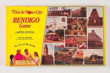
Leisure object - Board Game, E Systems Publications, This is Your City - Bendigo Game, 1985
This limited edition board game was produced in conjunction with local businesses and attractions and sponsored by the Bendigo Development Committee. Supported by the five local municipalities (pre amalgamation) and both State and Local governments, the role of the Committee was to promote Bendigo's economic development. Boxed board game. Yellow box lid featuring photographs of popular sights around Bendigo on right side and a family playing the game on the left on lid. Inside box includes game board, playing cards, dice and game rules. 0345a; Fold out game board. Commercially printed with a full colour stylised map of Bendigo and Eaglehawk. 0345b Set of 96 Destination Cards single side printing on coloured card 0345c Set of 32 Surprise Cards 0345d Paper money 0345e Player tokens 0345f Set of dice 0345g Letter to Players re the board game and local businesses on 'Bendigo Premier Town' letterhead. 0345h Three printed pages of discount vouchers for local businesses. 0345i Game Rulescity of bendigo premier town 1982-85, city of bendigo commerce -
 Mrs Aeneas Gunn Memorial Library
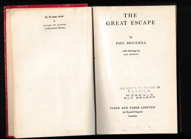
Book - The Great Escape, Faber & Faber, 1951
With only their bare hands and the crudest of homemade tools, they sank shafts, built underground railroads, forged passports, drew maps, faked weapons, and tailored german uniforms and civilian clothes. They developed a fantastic security system to protect themselves from the German "ferrets" who prowled the compounds with nerve-racking tenacity and suspicion. It was a split-second operation as delicate and as deadly as a time bomb.Ill, p.263.non-fictionWith only their bare hands and the crudest of homemade tools, they sank shafts, built underground railroads, forged passports, drew maps, faked weapons, and tailored german uniforms and civilian clothes. They developed a fantastic security system to protect themselves from the German "ferrets" who prowled the compounds with nerve-racking tenacity and suspicion. It was a split-second operation as delicate and as deadly as a time bomb. world war 1939-1945 - prisoners of war, world war 1939 1945 - escapes -
 Wodonga & District Historical Society Inc
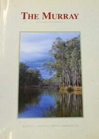
Book - THE MURRAY, Norman Mackay and David Eastburn, 1990
A study of the Murray River system, commissioned by the Murray Darling Basin Commission and published in 1990. This book provided a starting point for the understanding needed to make sustainable development og the Murray-Darling system an achievable goal. It provides a basis for action to halt futher degradation of the River and to rehabilitate its damaged environment. The picture that emerges from this volume is of a river in decline but not yet beyond saving. It covers topics such as groundwater and salinity, the associated fauna and flora, the surrounding environment, and the human impact. Illustrated with maps, diagrams and colour photographs. Includes a glossary and an index.non-fictionA study of the Murray River system, commissioned by the Murray Darling Basin Commission and published in 1990. This book provided a starting point for the understanding needed to make sustainable development og the Murray-Darling system an achievable goal. It provides a basis for action to halt futher degradation of the River and to rehabilitate its damaged environment. The picture that emerges from this volume is of a river in decline but not yet beyond saving. It covers topics such as groundwater and salinity, the associated fauna and flora, the surrounding environment, and the human impact. Illustrated with maps, diagrams and colour photographs. Includes a glossary and an index.upper murray region, murray river ecology, stream ecology murray river -
 Wodonga & District Historical Society Inc
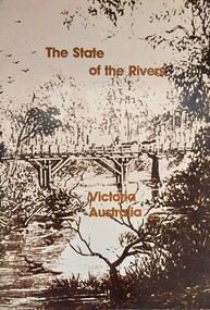
Book - The State of the Rivers, Victoria Australia, Constable, D & Smith, K, 1983
Rivers play an essential part in the life and wealth of our society. They are also the most striking feature of the landscape, contributing much to the beauty of rural and urban surroundings as well as to the recreation, peace and happiness of our people. This report includes historical colour and black and white photos and maps. It aimed to give an accurate account of the condition of the rivers of Victoria. It was produced by the Standing Consultative Committee on River Improvement.A 64 page volume including text, black and white and colour images and maps.Rivers play an essential part in the life and wealth of our society. They are also the most striking feature of the landscape, contributing much to the beauty of rural and urban surroundings as well as to the recreation, peace and happiness of our people. This report includes historical colour and black and white photos and maps. It aimed to give an accurate account of the condition of the rivers of Victoria. It was produced by the Standing Consultative Committee on River Improvement.rivers in victoria, conservation victoria, water supply victoria -
 Bendigo Military Museum
Photograph - 4th Field Survey Squadron deployed on Operation NERIGHT, Queensland & Northern Territory, 1989
This is a set of 19 photographs taken in 1989 during 4th Field Survey Squadron’s deployment on Operation NERIGHT 89 in Queensland and the Northern Territory. It was a two-part operation in 1989 with work conducted in the areas of Camooweal and Weipa. Part 1 was the field completion of topographic maps conducted near Camooweal QLD, along the Barkley Highway on the border between NT and QLD, from the 12th of September to the 20th of October 1989. A Bell Kiowa LOH helicopter from 162 Recce Sqn supported topographic field completion. Operation NERIGHT 89 Part 2 was the acquisition of mapping control by GPS field parties utilising Texas Instruments TI4100 Global Positioning System receivers around Weipa on Cape York Peninsula from the 22nd of September to the 22nd of October 1989. Part 2 Two Bell UH-1H Iroquois helicopters from RAAF’s 35 Squadron were principally used to deploy GPS field parties. Identification photography of control points was taken by air camera operators in AAAvn Pilatus Porter aircraft from 173 Gen Spt Sqn fitted with an RC10 aerial camera. The two parts of the operation were conducted concurrently. This is a set of 19 photographs taken in 1989 during 4th Field Survey Squadron’s deployment on Operation Neright in Queensland & the Northern Territory. The colour photographs are on 35mm negative film and are part of the Army Survey Regiment’s Collection. The photographs were scanned at 96 dpi. .1) to .3) - Photo, colour, 1989. En-route to areas of survey operations. .4) to .5) - Photo, colour, 1989. Unidentified personnel relax next to river/waterhole. .6) - Photo, colour, 1989. Two Bell UH-1H Iroquois helicopters from RAAF’s 35 SQN utilised in the movement of GPS parties. .7) to .9) - Photo, colour, 1989. Unidentified soldier practices repelling from a UH1H Iroquois helicopter. .10) - Photo, colour, 1989. Inside the cockpit of a UH1H Iroquois helicopter. .11) - Photo, colour, 1989. Field Party camp with GPS equipment in foreground. Unidentified soldier prepares a meal. .12) - Photo, colour, 1989. GPS antenna plumbed over a survey ground mark. Witness post on left. .13) & .14) - Photo, colour, 1989. Unknown Cape York Peninsula beaches. .15) & .16) - Photo, colour, 1989. Dramatic fire next to base camp. .17) - Photo, colour, 1989. Aboriginal rock art at unknown location. .18) - Photo, colour, 1989. Aboriginal rock art at unknown location. L to R: unidentified, SPR Andrew Quin. .19) - Photo, colour, 1989. Aboriginal rock art at unknown location. LT Chris Topovsek..1P to .19P – There are no personnel identified. ‘1989 OP NERIGHT’ annotated on negative sleeve.royal australian survey corps, rasvy, 4 fd svy sqn, op neright 89