Showing 385 items
matching ordnance
-
 Bendigo Historical Society Inc.
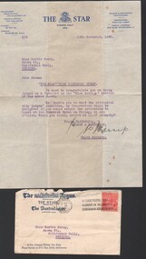
Letter - Gertrude Perry Collection - The Star (newspaper) invitation to Miss G. Perry to attend a lunch as a "Miss Bendigo" as part of the Bendigo Easter Fair Society 1935. A separate invite refers to 1939 Bendigo Easter Fair
Gertrude Perry was born in California Gully in 1917. Her singing skills were recognized at an early age. She later sang with local choirs and sang on radio. She was involved with the Bendigo Operatic Society for many years. Gertrude began her working life in sales. After studying book keeping she worked at the Bendigo Ordnance Factory during WW2 and then worked for local solicitors and accountants. Gertrude was involved with many community and sporting organizations.Gertrude Perry Collection - The Star (newspaper) letter and invitation to Miss G. Perry to attend a lunch as a finalist in the "Miss Bendigo" as part of the Bendigo Easter Fair Society on Friday (??) 1935 at one o'clock. The invitation is separate to the letter as it is for the 1939 Bendigo Easter Fair Charity Carnival, no date is specified on the invitation. Miss Perry raised the "record sum of One Thousand and One Pounds" Signed by the sales manager of The Star (newspaper)physical culture class, fitness, exercise, bendigo easter fair -
 Bendigo Historical Society Inc.
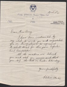
Letter - Gertrude Perry Collection - handwritten letter from Bendigo YMCA congratulating Miss Perry on being chosen to represent Mitchell Street for the 1941 Miss Popular Girl Competition for the Bendigo Easter Fair
Gertrude Perry was born in California Gully in 1917. Her singing skills were recognized at an early age. She later sang with local choirs and sang on radio. She was involved with the Bendigo Operatic Society for many years. Gertrude began her working life in sales. After studying book keeping she worked at the Bendigo Ordnance Factory during WW2 and then worked for local solicitors and accountants. Gertrude was involved with many community and sporting organizations.Gertrude Perry Collection - handwritten letter from Bendigo Y.M.C.A. Amateur Athletic Club congratulating Miss Perry on being chosen to represent Mitchell Street for the 1941 Miss Popular Girl Competition for the Bendigo Easter Fair.Signed G.G. Glover (Hon. Sec.) social, bendigo easter fair -
 Bendigo Historical Society Inc.
Letter - Gertrude Perry Collection - Bendigo Easter Fair Society letter
Gertrude Perry was born in California Gully in 1917. Her singing skills were recognized at an early age. She later sang with local choirs and sang on radio. She was involved with the Bendigo Operatic Society for many years. Gertrude began her working life in sales. After studying book keeping she worked at the Bendigo Ordnance Factory during WW2 and then worked for local solicitors and accountants. Gertrude was involved with many community and sporting organizations.Gertrude Perry Collection - Bendigo Easter Fair Society letter, 28th February 1991; inviting Miss Perry to the inaugural Bendigo Easter Fair Popular Girls 1930 - 1991. The reunion is to be held at the Senior Citizens Centre, Bendigo Library, Hargreaves Street, Bendigo on Sunday 24 March 1991. Letter sent under the Sandhurst Trustees Bendigo Easter Fair letterhead.physical culture class, fitness, exercise, bendigo easter fair -
 Bendigo Historical Society Inc.
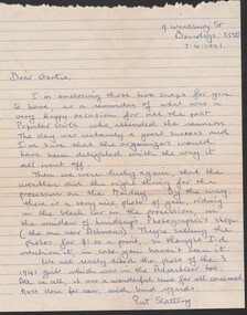
Letter - Gertrude Perry Collection - handwritten note from Pat Slattery to "Gertie" referring to the reunion of the Bendigo easter Fair Miss Popular Girls on 7 April 1991
Gertrude Perry was born in California Gully in 1917. Her singing skills were recognized at an early age. She later sang with local choirs and sang on radio. She was involved with the Bendigo Operatic Society for many years. Gertrude began her working life in sales. After studying book keeping she worked at the Bendigo Ordnance Factory during WW2 and then worked for local solicitors and accountants. Gertrude was involved with many community and sporting organizations.Gertrude Perry Collection - handwritten note from Pat Slattery to "Gertie" referring to the reunion of the Bendigo Easter Fair Miss Popular Girls on 7th April 1991. The letter refers to two photos the writer has attached but which are not included in the folder. Lined paper has been torn from a writing pad. The letter has two fold marks.physical culture class, fitness, exercise, bendigo easter fair -
 Bendigo Military Museum
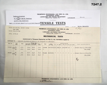
Document - MECHANICAL TEST RESULTS, Thompson's Engineering and Pipe Works, 26 Mar 1943
By referring to Cat No 7237.2 will bring all items associated with Thompsons.1. Single sheet of paper. From Thompson's Engineering & Pipe Co Ltd to Ordnance Factory Maribyrnong. A/c Ministry of Munitions. Titled - mechanical tests - Test on 25 PDR Breech rings. Rings NR (1790-1793). Dated 26 March 1943. 2. Tensile tests on material for 95 (loose) Barrel forgings for 25 PDR Gun Howitzers. From Thompson's to Commonwealth of Australia - Ministry of Munitions. Barrel 14236/1 (Y2) - Barrel 635/3 - Dated 18 Feb 1942.1. Top has name "Mr. Johnson" written. In the middle is an unidentifiable signature dated 26-3-1943. Bottom has (??) Martin. 2. At bottom signed off by (??) Martin.25 pdr, thompson's castlemaine, ordnance factory maribyrnong. -
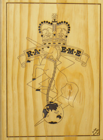
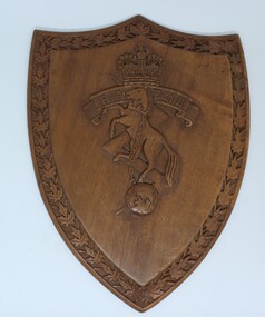 Wodonga & District Historical Society Inc
Functional object - RAEME Shield, c1978
RAEME Corps was first established in 1942 when the Ordnance Corps and the Service Corps were combined. The royal ascent was granted in 1948. The Royal Australian Electrical and Mechanical Engineers (RAEME) is a technical corps tasked with the maintenance of the Army's modern hardware and equipment. RAEME personnel are represented in most Army units. The Royal Australian Electrical and Mechanical Engineers corps motto is ‘Arte et Marte’, which is Latin for ‘With Skill and Fighting’. This item, was presented to the Council of the Rural City of Wodonga in 1978. RAEME has a strong connection with the city of Wodonga through its service and training facilities at the Bandiana base on the edge of Wodonga. A shield shaped plaque carved with the emblem of RAEME corps (The Royal Australian Electrical and Mechanical Engineers corps). The edge of the shield is decorated with carved leaves. An engraved metal plate has been attached to acknowledge the presentation of the plaque to the Council of the Rural City of Wodonga. The rearing horse and chain are symbolic of power under control and the lightning flash, of electrical engineering. The rearing horse also forms part of the crest of the Institution of Mechanical Engineers and, together with the lightning flash, is intended to mark the close relationship which exists between the electrical and mechanical engineers in both civil and military life. The globe is indicative of the impact of engineering on the world generally.Attached to rear of shield "Presented to/The Council of the Rural CIty of Wodonga/ by/ The Commanding Officer and Members of/RAEME Training Centre/ 21 October 1978"raeme, australian army -
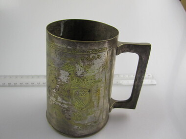 Ballarat RSL Sub-Branch Inc.
Tankard (Med)
This object relates to James Tennyson BENTLEY. He was born on 05/01/1927 in South Yarra, VIC. James Tennyson served in the Army (VX96171) enlisting on, 23/01/1945 in North Melbourne, VIC before being discharged from duties with the 21 ARMY ORDNANCE DEPOT as a Army Non-Commissioned Private (PTE) on 12/12/1947. James Tennyson BENTLEY was not a prisoner of war. His next of kin is Christina BENTLEY. Brass used for the manufacture of this tankard was salvaged from the battle fields of World War II.Engraved with map - "Persian Gulf Command"second world war (ww2), 1939 - 1945, collectables, ballarat rsl, ballarat -
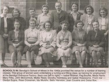 Bendigo Historical Society Inc.
Newspaper - JENNY FOLEY COLLECTION: SCHOOL'S IN
Bendigo Advertiser "The way we were" from Tuesday, June 22, 2004. School's in: Bendigo's School of Mines in the 1940s provided the venue for a number of training classes. This group of women were undertaking a turning and fitting class, as training for employment at the Bendigo Ordnance Factory. Back row from left: Isabel Widmar, Peg Bourke, Marje Harris, Mary Fittis, John McCormick, Mollie Reed, Dorothy Holmberg and Isabel Rosewarne. Front row: Gladys Evans, Rose Crossman, Ida Murphy, Betty Harreton, Joan Cousins and Dulce Box.newspaper, bendigo advertiser, the way we were -
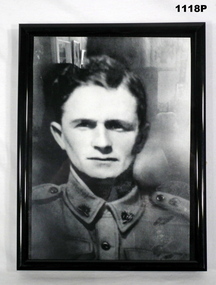 Bendigo Military Museum
Photograph - PHOTOGRAPH WW2, FRAMED, 1941
Raymond James Russel WHYTE Initially enlisted on 16.8.40 as V28354 serving in 2 Cav Div ASC. He was discharged on 6.10.41 his enlistment date into the AIF on his records is stated as 1.10.1941 age 24 years 4 months. Taken strength at RRD Royal Park on 7.10.1941, posted to 2/10th Ordnance W/Shops 2.1.1942, embarked for Malaya 10.1.1942 arriving 26.1.1942, reported missing 16.2.1942, listed POW dated 29.10.1942, deceased while POW, cause not stated 5.6.1945. Raymond died in Borneo on the Sandakan Death March.Photo, B & W Portrait of R.J.R. Whyte in uniform, no hat on. Photo is in a black plastic frame.photography - photgraphs, military history, sandakan, borneo -
 Bendigo Military Museum
Photograph - PHOTOGRAPH WW2, FRAMED, 1941
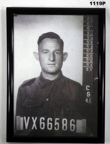
William Patrick SHEPHERD No VX66586 enlisted in the 2nd AIF on 26.11.1941 age 25 years 10 months at RRD Royal Park. Transfers to A.A.S.C on 3.12.1941 then posted to 2/10th Ordnance W/Shops, embark for Malaya 10.1.1942 arriving Singapore 26.1.1942, listed Missing 16.2.1942, listed as POW 13.4.1943, dated 28.9.1945 listed as deceased whilst POW, cause not stated 5.6.1945. A letter to Mrs Sheperd dated 18.1.1946 states died of Malaria. This was from Japanese records mostly. William died on the Sandakan Death March Borneo.Photo B & W portrait of W.P Sheperd in uniform no hat. Photo taken with his Regt No. Display at bottomphotography - photographs, military history, sandakan, borneo -
 Bendigo Military Museum
Award - MEDAL SET, Post WW1 and Post WW11
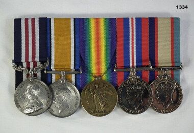
John Thomas O'Bree enlisted in 20th reinforcements 22nd Batt AIF on 4.7.16. As a Stretcher Bearer he was awarded a "Military Medal on 4.10.18 during an attack at Estrees east of Peronne. He worked without rest for 24 hours bringing out wounded lying helpless under concentrated shell fire and machine guns. Hospitalised on 20.10.18 with Influenza. Discharged from the AIF on 27.10.19. He enlisted again during WW11 on 24.4.41 for home service in the CMF, served in various Garrison Bn’s Ordnance and Salvage depots and was discharged on 18.1.45.Medal set, court mounted, set of (5) re J.T O'Bree. 1. Military Medal. 2. British War Medal 1914-19. 3. Victory Medal. 4. War Medal 1939-45. 5. Australian Service Medal.1 "6865 Pte J T O'Bree 22 Aust Inf" 2 & 3 "6865 Pte J T O'Bree 22 Bn" 4 & 5 "V13666 J T O'Bree"medals, military, history -
 Montmorency/Eltham RSL Sub Branch
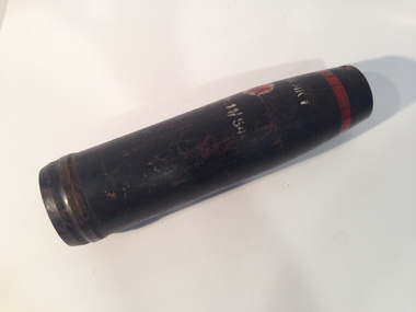
Weapon - Artillery shell for 25 pounder Gun/Howitzer, Artillery Shell, 1954
The Ordnance QF 25-pounder was the major British field gun and howitzer during the Second World War. Many Commonwealth countries used them during WW2 and Australia produced the guns at General Motors Holden. They were renowned for their rapid rate of fire and when firing at maximum range (12,253m -13,400yds) one gun could have up to 5 shells in the air at once. In North Africa during WW2, they were sometimes called upon to act as anti-tank guns. A shortened and lightened version of the gun was made in Australia and used in jungle operations.Steel conical projectile25 PR MK 1 L35 ME 11/54 -
 4th/19th Prince of Wales's Light Horse Regiment Unit History Room
Envelopes, Commemorative, Australia - 7 July 1982, NZ - ?
Sets of Australian and New Zealand stamped commemorative envelopes. Australia: 1AR, RAAC- Cambrai, 1 AR Standard, Armoured Centre, 2 Cav, 3 Cav, 4 Cav, 1/15 RNSWL, 2/14 LH (QMI), 3/9 SAMR, 4/19 PWLH, 8/13 VMR, 10 LH, 12/16 HRL, Beersheba. New Zealand: Otago University Medical Corps, RNZ Education Corps, Home Guard, Ordnance, Start of War, Disbanding of RNZ Service Corps, Anniversary of South Africa, NZ Army Day. -
 National Vietnam Veterans Museum (NVVM)
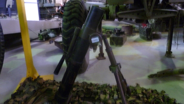
Weapon, 60mm Mortar, 1960's
The Chinese type 31 60mm Mortar is a copy of the US M2 Mortar. The mortar consists of a barrel, bipod and baseplate. The barrel is made from ordnance steel and has a smoothbore profile. the breech end has a ball and socket arrangement that fits into the baseplate. The tripod is adjustable for traverse and elevation and can be folded for transportation purposes and is fitted with a leather binding strap. The baseplate is square in profile and is made from pressed metal. A canvas carry strap is fitted through two loops in the top surface. There are anchor spikes at the bottom of the baseplate. The mortar is painted camouflage in black, brown and olive drab.INNOC. Serial numbers : Base Plate 9307 330937; Bipod 9364south east asia, vietnam, vietcong, weapon -
 Melbourne Tram Museum
Document - Instruction, Melbourne & Metropolitan Tramways Board, Mal Rowe, Destination Signs on Munitions Factory Extras, 1942
Printed copies of a digital copies of Instructions issued by the MMTB regarding World War 2 notices to crews. .1 - Notice C4608 - Destination Signs on Munitions Factory Extras - dated 24/2/1942 to Essendon, Footscray and Central Bus Garage crews - when the various signs and route number letters were to be used on Explosives Factory, Ordnance Factory and Ammunition Factory to be shown on trams. .2 - Notice C4551 - "Running to and from Explosives and Ordinance factories - Instructions regarding destination signs to be shown for trams from Brunswick, Malvern, Glenhuntly and Hanna St depots.trams, tramways, world war 2, footscray, destination roll, maribyrnong, west maribyrnong, explosives factory, ordnance factory, ammunition factory -
Clunes Museum
Weapon - NAVAL CANNON, 1847
IT IS ON PERMAMENT LOAN FROM HEPBURN SHIRE THE CANNON WAS ORIGINALLY ON THE BRITISH NAVAL SHIP "NELSON" IN FEBRUARY 1867. "NELSON" WAS HANDED OVER TO THE VICTORIAN NAVAL FORCES, ON LOAN FROM THE ROYAL NAVY. "NELSON" WAS SOLD 1898, IT IS BELIEVED THAT THE GUNS WERE THEN OFFERED FOR SALE TO COUNCILS. IT WAS DISPLAYED ON A SITE NEAR THE SCENIC ROAD, CLUNES, UNTIL THE WOODEN UNDERCARRIAGE WAS DESTROYED BY THE BUSHFIRES IN 1944. IT WAS LATER RETRIEVED AND KEPT IN THE CLUNES BOROUGH COUNCIL YARD UNTIL IT WAS RESTORED BY THE APPRENTICES AT THE BENDIGO ORDNANCE WORKSHOPS IN 1895. THE TIMBER USED FOR THE RESTORATION WAS TAKEN FROM AN ELM TREE NEAR THE CREEK IN CLUNES..1 NAVAL CANNON MOUNTED ON A WOODEN UNDERCARRIAGE. .2 CANNON BALLlocal history, military history, navy, military -
 8th/13th Victorian Mounted Rifles Regimental Collection
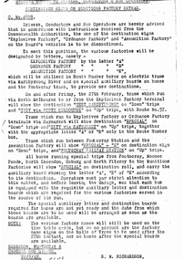
Photograph - Governor General's escort Bandiana 4.12.81
Sir Zelman Cowan, Governor General of Australia, made a visit to Bandiana to present the Sovereign's Banner to the Royal Australian Army Ordnance Corps (RAAOC). The 8/13 Victorian Mounted Rifles Light Horse Heritage Troop provided a mounted escort for Sir Zelman and Lady Cowan. The escort was under the command of Captain (later Major) Robert Morrison, a keen horseman, who had been the prime mover in raising the Heritage Troop. All riders were serving soldiers of A Squadron 8/13 Victorian Mounted Rifles and their horsed activities were additional to their normal training responsibilities. Black and white photograph of Lieutenant R Morrison riding Cherokee (left) and Sergeant S Berg riding Postie (right) either side of a car carrying the Governor General Sir Zelman Cowan at Bandiana 4 December 1981.bandiana, light horse, morrison, berg, sir zelman cowan, governor general -
 8th/13th Victorian Mounted Rifles Regimental Collection
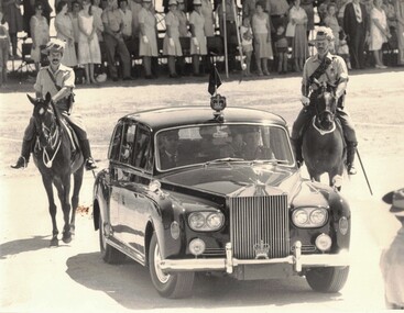
Photograph - Escort to Governor General 1981
Sir Zelman Cowan, Governor General of Australia, made a visit to Bandiana to present the Sovereign's Banner to the Royal Australian Army Ordnance Corps (RAAOC). The 8/13 Victorian Mounted Rifles Light Horse Heritage Troop provided a mounted escort for Sir Zelman and Lady Cowan. The escort was under the command of Captain (later Major) Robert Morrison, a keen horseman, who had been the prime mover in raising the Heritage Troop. All riders were serving soldiers of A Squadron 8/13 Victorian Mounted Rifles and their horsed activities were additional to their normal training responsibilities. Black and white photograph of light horse escort to Governor General Sir Zelman Cowan at Bandiana 4 December 1981. Riders are Lieutenent R Morrison, Sergeant S Berg, Corporals F Reynolds, A Florient, Lance Corporal Milgate, Troopers C Ellison, K Dudley, Anderson, McDonald.light horse, morrison, bandiana, sir zelman cowan -
 Bendigo Military Museum
Document - MEMORANDOM RE TESTS, Thompson's Engineering and Pipe Works, 1942
By referring to Cat No 7237.2 will bring up all items associated with Thompsons.These are typed copies of work documents. They are on a lightweight pink paper. They are from Thompson's Engineering to the Bendigo Ordnance factory, Naval Dept. 1. Dated 7 Oct 1942 for tests on breech ring billed in "D" steel contract MON1775. 2. Dated 13 Oct 1942 for tests on Gun metal castings 4"Naval Guns, and Class "D " stee4l for breech rings for 4" Naval Guns. 3. Dated 29 Oct 1942. Test on gunmetal castings. 4. Dated 4 Nov 1942. Tests covered by 3 particular contracts. 5. Dated 25 Nov 1942, For Mechanical tests on a spcific contract. 2.3. & 5. Rubber stamp of a signature - illegibleww2, cannons, manufacture -
 Lara RSL Sub Branch
Plaque - RAEME Plaque
RAEME Corps was first established in 1942 when the Ordnance Corps and the Service Corps were combined. The royal ascent was granted in 1948. Ref: www.raeme.org.au The Royal Australian Electrical and Mechanical Engineers (RAEME) is a technical corps tasked with the maintenance of the Army's modern hardware and equipment. RAEME personnel are represented in most Army units, with the representation varying in size from one or two tradespersons, to small groups of 20 to 30 tradespersons, to large maintenance units with over 150 personnel and a totally integrated military and civilian workforce. The Royal Australian Electrical and Mechanical Engineers corps motto is ‘Arte et Marte’, which is Latin for ‘With Skill and Fighting’. Ref: www.army.gov.auVarnished Wooden BoardRAEME Badge Jan Zyla George Zyla 2020 -
 Bendigo Military Museum
photograph - Fortuna - 1st Year of Army Occupation in Bendigo, 1942
This is a set of 17 photographs taken during the first year of Army occupation at Fortuna, Bendigo in 1942. The photos provide an insight into the preparatory work performed on the Fortuna Villa and surrounding buildings, by the Working Party 5th Army Troop and Ordnance Training Depot, before its occupation by personnel from LHQ Cartographic Company, Royal Australian Survey Corps. The annotation on the back of Photos .9P and .10P is misspelt. The correct spelling is ‘Nell Gwynne’. The poppet head of the Central Nell Gwynne mine is still an iconic landmark in Bendigo, lying just down the road from the poppet head lookout at Victoria Hill. The Central Nell Gwynne was the premier mine of Bendigo's 1930s mining revival and is of high historical value, due to the extensive and relatively intact features which remain at the site. The annotation on the back of Photo .17P is incorrect. The location of HQ 5th Army Troop was ‘Reynard St, Coburg.’ By late 1941 as Japan extended its control throughout Indo-China, resolving the accommodation problem of AHQ Cartographic Company located in Melbourne became more urgent. The steady Japanese advance made the bombing of Melbourne no longer a remote possibility, and in accordance with a general policy of dispersion, the Deputy Chief of the General Staff, Major General Sidney Rowell instructed Major William Sarll, in the interests of security of plant and to provide against possible damage of air attack, to investigate suitable safer inland accommodation for AHQ Cartographic Company. Major Sarll inspected many properties before finding one that would meet the requirements of the Cartographic Company. In late 1941, he came to inspect Fortuna, a rambling old mansion with about fifteen acres of ground in central Bendigo. Initially there was no intention to occupy the site beyond the end of the war, although Major Sarll's report to the Director of Survey noted many advantages in moving the Company to Bendigo. Major General Rowell quickly approved the selection of Fortuna before other authorities, which were investigating the evacuation of school children, could get in ahead of the Cartographic Company. On 23 March 1942, the Commonwealth of Australia, under the provisions of the National Security Act of 1939, took possession of the house, the old battery buildings and the fifteen acres of grounds. Under Warrant Officer J. Trist’s direction, over fifty Parks and Works tradesmen completed building works necessary to accommodate the Survey Corps’ military, map making and printing requirements. The building program was still under way when the first officer, Lieutenant Ralph Westgarth, arrived in May 1942 with the advance party which received and positioned all equipment as it came up from Melbourne in semi-trailers. Once the equipment was installed the rest of the Cartographic Company completed its shift to Bendigo by 11th June 1942. The first year of the Survey Corps’ occupation of Fortuna is covered in more detail with additional historic photographs, in pages 17-22 of Valerie Lovejoy’s book 'Mapmakers of Fortuna – A history of the Army Survey Regiment’ ISBN: 0-646-42120-4.This is a set of 17 photographs taken during the first year of Army Occupation at Fortuna, Bendigo in 1942. The black and white photographs were printed on photographic paper and are part of the Army Survey Regiment’s Collection. The photographs were scanned at 300 dpi. .1) - Photo, black & white, 1942. Bendigo Parks and Works tradesmen at Fortuna. L to R: Cliff Day, Ernie Arnold, Norm? .2) - Photo, black & white, 1942. “Don” - possibly SGT Don Sutcliffe. Fortuna, Bendigo. .3) - Photo, black & white, 1942. Parks and Works tradesmen in garden at Fortuna, Bendigo. L to R: Fred & Ernie. .4) - Photo, black & white, 1942. Benny Jack Williams at Fortuna, Bendigo. Accommodation tents were erected above the lake, which later became the parade ground. .5) - Photo, black & white, 1942. Working dress - Giggle suits. Parks and Works tradesmen at Fortuna, Bendigo. L to R: Cliff and Harry on big roof. .6) - Photo, black & white, 1942. Parks and Works tradesmen at Fortuna, Bendigo. Ted on big roof. .7) - Photo, black & white, 1942. Gold crusher battery just behind Fortuna. .8) - Photo, black & white, 1942. Scene of Bendigo from Fortuna. .9) - Photo, black & white, 1942. Nell Gwynne Mine from mullock heap at Victoria Hill near Fortuna, Bendigo. .10) - Photo, black & white, 1942. Nell Gwynne Mine and crusher near Fortuna, Bendigo. .11) - Photo, black & white, 1942. Sluicing for gold at Eaglehawk. .12) - Photo, black & white, 1942. Fortuna, Bendigo taken from the far side of tennis courts. .13) - Photo, black & white, 1942. Fortuna, Bendigo & its reflection from across the lake. .14) - Photo, black & white, 1942. Fortuna, Bendigo from the fishpond. .15) - Photo, black & white, 1942. Fortuna, Bendigo. .16) - Photo, black & white, 1942. First Fortuna Football Team at unknown location. L to R: 5th Bob Wright, 11th SGT Don Sutcliffe. .17) - Photo, black & white, 1942. Working Party from 5th Army Troop and Ordnance Training Depot at Fortuna, Bendigo.Some personnel are identified. Annotated with date within photos. .1) – Annotated on back ‘Cliff, Ernie, Norm, Dec ‘42. Cliff Day - dairy farmer, plasterers’ labourer. Ernie Arnold – hard plasterer. Norm? - QM Store for tools etc. QM Store was the Stables.’ .2) - Annotated on back ‘Don. Fortuna 1942’ .3) - Annotated on back ‘Fred & Ernie. Dec 1942. Carpenters. Note the state of the gardens.’ .4) - Annotated on back ‘Benny Jack Williams Fortuna Bendigo. Tents were erected where present day parade ground is above the lake.’ .5) - Annotated on back ‘Working dress - Giggle suits. June 42. Cliff and Harry on big roof. This photo was taken as the ventilating ridge was being installed on the building housing the printing machines. The machines were installed later by civilian labour when building was complete.’ .6) - Annotated on back ‘Ted on big roof Fortuna Bendigo.’ .7) - Annotated on back ‘Gold crusher battery – Bendigo for slay heap – 1942. 12 stamp battery. Just behind Fortuna. Was working at night when the “Army” came to Bendigo. Later removed to “Coolgardie - WA. Present site of Southern Cross TV.’ .8) - Annotated on back ‘Scene of Bendigo from Fortuna. June 1942.’ .9) - Annotated on back ‘Nell Gwyne Mine from mullock heap (Victoria Hill) Sept 1942.’ .10) - Annotated on back ‘Nell Gwyne Mine and crusher September 1942.’ .11) - Annotated on back ‘Sluicing for gold at Eaglehawk. August 1942.’ .12) - Annotated on back ‘Fortuna Bendigo 1942. Taken from far side of tennis courts.’ .13) - Annotated on back ‘ “Fortuna” across the lake & reflection.’ .14) - Annotated on back ‘Fortuna from fishpond June 1942.’ .15) - Annotated on back ‘Fortuna Dec 1942.’ .16) - Annotated on front ‘X’ x2. Annotated on back First Fortuna Football Team 1942‘Bob Wright’, ‘SGT Don Sutcliffe’. .17) - Annotated ‘Working Party at Fortuna before one of the drafts’, Working Party 5th Army Troop and Ordnance Training Depot Showgrounds, now the Sportsground Bendigo’, ‘HQ of 5th Army Troop was Reynards Rd, Coburg.’royal australian survey corps, rasvy, army survey regiment, army svy regt, fortuna, asr -
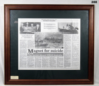 Bendigo Military Museum
Newspaper - NEWSPAPER CUTTING, FRAMED, Bethany Gallery, HMAS AUSTRALIA, 2.4.1994
Reference 2314 medals and service history re Warick Niven Johanson PM4958 RAN. Also 286P, 2566P. Warwick is first on the left in the article. The other three are; Norman Stanley Winzar PM7506. Enlisted 20.6.1944 age 19 years. Discharged from the RAN 25.7.1946 with the rank of Able Seaman at HMAS Lonsdale. Alexander Dundas Reid PM5769. Enlisted 11.1.1943 age 21 years. Discharged from the RAN 21.5.1946 with the rank OA111 (Ordnance Artificer 3) at HMAS Lonsdale. Neil Knox PM2072. Enlisted 3.11.1939 age 19 years. Discharged from the RAN 31.1.1946 with the rank LDG Seaman (Leading) at HMAS Lonsdale. HMAS Lonsdale was shore based facility in Port Melbourne.Photocopy of a newspaper article, Bendigo Advertiser, page 14, Saturday 23.4.1994. The photo in article shows 4 Bendigo ex Sailors. Magnet for Suicide. The horror aboard HMAS Australia. documents - newspapers, cuttings, frame accessories, hmas australia -
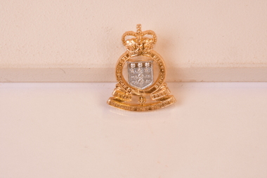 Chiltern Athenaeum Trust
Royal Australian Army Ordinance Corps Hat Badge : 1953 to 1960, 1953 to 1960
The Royal Australian Army Ordnance Corps (RAAOC) is the Corps within the Australian Army concerned with supply and administration, as well as the demolition and disposal of explosives and salvage of battle-damaged equipment. The Corps contains clerks, operator supplies (including q-store staff, warehouse staff and food technicians), petroleum operators, parachute riggers and ammunition technicians. Members of the Corps are nicknamed Roaches. Unlike other Corps within the Australian Army, there are no longer any RAAOC specific units, instead RAAOC sub-units sit within mixed units such as Combat Service Support Battalions (CSSBs) or Force Support Battalions (FSBs). RAAOC is also responsible for clerks and quartermaster store staff in all Australian Army Units.Circa 1953 to 1960. Associated with the supply chain and equipment resourcing within The Royal Australian Army. Gold and silver chrome hat corps badge. The reverse has two pin points that a stud affixes to so as to secure to a hat or cap. The top of the badge has a crown shape and the bottom is curved. There is corps writing on the badge at the bottom and surrounding sides : "Royal Australian Army Ordinance Corps". Royal Australian Army Ordinance Corps. 1953 to 1960 raaoc corps hat badge, royal australian army ordinance corps, raaoc -
 Wodonga & District Historical Society Inc
Uniform - Australian Military Uniform - RAEME Corps, c1965
RAEME Corps was first established in 1942 when the Ordnance Corps and the Service Corps were combined. This uniform was donated by a RAEME member who served during the Vietnam War. The Corps began sending advisers to Vietnam in 1964 and this foreshadowed a massive build- up of RAEME personnel and equipment which peaked in 1971. The first direct RAEME support was provided in early 1965 as part of 1 Aust Logistic Support Coy (1 ALSC). Prior to 1971 the RAEME elements of 1 Australian Logistic Support Group built up to a stage where there were two field workshops. The withdrawal of all Australian forces was completed in 1972 and RAEME reverted to its peacetime role.This uniform was worn by a member of the Wodonga community who served with RAEME during the Vietnam War. RAEME Corps members are also represented at the Army Logistic Training Centre at Bandiana.Australian Military uniform - this uniform was issued during Australia's involvement in the Vietnam war. It was worn by a member of RAEME (The Royal Australian Engineers), Damien Hunt who is a resident of Wodonga.On shoulder badge: "ROYAL AUSTRALIAN ELECTRICAL / & MECHANICAL ENGINEERS"raeme, military uniforms, australian army -
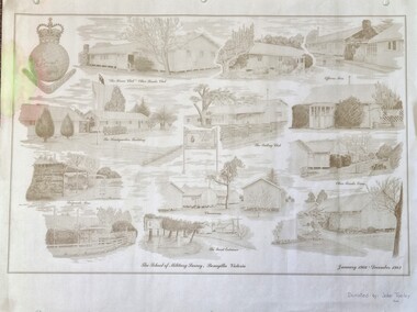 Wodonga & District Historical Society Inc
Work on paper - Sketch - The School of Military Survey, Bonegilla, 1970s
Bonegilla operated as an army base from September 1940 and by 1943 was expanded to 848 buildings, including a general hospital. It provided training for small arms instructors, signallers, transport workers, bomb disposal and gas warfare personnel. In a response to the need to house the growing number of displaced persons coming to Australia, the Bonegilla Reception and Training Centre began operating in 1947. For some time it was a shared facility but the Army withdrew temporarily from Bonegilla in 1949, whilst still retaining ownership of the site. From 1949-65 Bonegilla Reception and Training Centre operated without a military presence. However, in the late 1960s and Australia’s commitments to the Vietnam War and pressed by the need to find accommodation to train men, especially National Servicemen, the Army negotiated with the Department of Immigration to take over several blocks at Bonegilla in 1965. Thirty-five huts were acquired by the Royal Australian Army Ordnance Corps as a Recruit Training Centre in which National Servicemen and recruits could attend 10-week ordnance courses. Shortly afterwards additional huts were acquired by the School of Military Survey, which established field-survey practical training areas and special astronomical observation sites as it began conducting courses in surveying. Instructors and trainees co-located at Bonegilla with migrant reception centre. In 1971 the Reception Centre closed and the site reverted to the Army. Progressively after 1971 the Army undertook a major site redevelopment with the construction of Latchford Barracks as the Army Apprentice School. Later Latchford Barracks was redeveloped into part of the Army Logistic Training Centre. Block 19 of the Mirant Reception Centre later became the Bonegilla Migrant Experience Heritage Park.This item depicts a heritage listed historical site located in the Wodonga district.A large poster size representation of the variety of buildings at Bonegilla, Victoria when it served as the location for the Royal Australian School of Military Survey. The insignia of the Royal Australian Survey Corps is featured in the top left hand corner.Top left corner: Insignia of the Royal Australian Survey Corps At bottom of sketches: "The School of Military Survey, Bonegilla Victoria / January 1966 - December 1982migrant reception centre bonegilla, army at bonegilla, australian military -
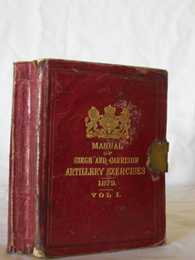 Flagstaff Hill Maritime Museum and Village
Book - Instruction Manual, British War Office, Manual of Siege and Garrison Artillery Exercises Vol 1, ca 24-06-1882
This little book has been designed to fit into a small space such as a pocket, backpack or trunk. The brass book lock helps keep the pages and covers together, preserving them from being bent, torn or damaged in handling.The book includes four of ten parts of the Manual, published for use in training the garrison troops, including the placement and firing of cannon. The four parts included in this Volume I are: - Part 1 - Gunnery Part 2 - Ammunition Part 3 - Siege Artillery Part 4 - Garrison Gun Drills The remaining six of then parts are: - Part 5 - Material and Appliances Part 6 - Elementary Instruction Part 7 - Machines Part 8 - Mounting and Dismounting Ordnance Part 9 - Sleighs Part 10 - Sheers and DerricksThe book is significant to both British and Australian history, being issued for the training of the garrison defense of both countries in the late 10th Century. It is also significant for its connection with other historical military items within the Collection at Flagstaff Hill Maritime Museum and Village.Manual of Siege and Garrison Artillery Exercises Vol 1 [Parts I, II, III, IV] Publisher Her Majestys Stationery Office Date 1879, Corrected June 24th 1882 Small, red, hard-cover book with embossed gold letters and British Coat of Arms on the front. The book has a brass closure or locking clip across the text block. There are diagrams and a foldout table within the text. flagstaff hill, flagstaff hill maritime museum and village, warrnambool, maritime museum, maritime village, great ocean road, shipwreck coast, training manual, book, british garrison, garrison artillery, siege exercises, british government training book, technical book, pocket book, manual of siege and garrison artillery exercises vol 1, garrison exercises, military training, defense training, british artillery, royal artillery, gunnery, gun drill, brass book lock, british war office, locking clip, reference book -
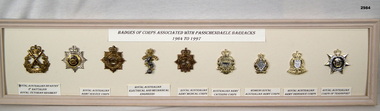 Bendigo Military Museum
Badge - BADGES, FRAMED, c.1998
Cream wooden framed selection of 9 badges displayed on cream coloured background.Top centre: “BADGES OF CORPS ASSOCIATED WITH PASSCHANDAELE BARRACKS 1964 TO 1977” Underneath each badge: “1. Royal Australian Infantry 2nd Battalion Royal Victorian Regiment 2. & 3. Royal Australian Army Service Corps 4. Royal Australian Electrical & Mechanical Engineers” 5. Royal Australian Army Medical Corp 6. Australian Army Catering Corp 7. Women's Royal Australian Army Corps 8. Royal Australian Army Ordnance Corps 9. Royal Australian Corps of Transportpasschendaele barracks trust, badges, framed -
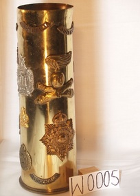 Doncaster RSL Sub Branch
Shell Case, 18 Pound Shell Case, shell case marked 1940
Brass shell case with various insignia attachedInsignia; Royal Marines Epaulette;Royal Marines Gibralter; Kings Own Scotland Borderers;Royal Army Ordnance Corp;Australian Engineers; Australian Intelligence Corp;Tank Corp Badges;Australian Rising Sun Hat Badge AIF;Tunic Collar Badge AIF; Australian Epaulette AIF;Australian Artillery Hat Badge Perm Forces;Cross Cannons with No 70 Italian found in abandoned fort in North Africa1941;Eagle with spread wings Italian pound in abandoned fort North Africa -
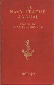 Bendigo Historical Society Inc.
Book - THE NAVY LEAGUE ANNUAL
A red hard covered book with an illustration of an anchor on the front cover. Titled ''The Navy League Annual.'' '' (corrected to October 10th, 1909). Founded and edited by Alan H. Burgoyne. :The Fleet of England is her all in all.'-Tennyson. Third year of issue. Part 1 The Editor Part 11Lord Elcho; Graf Ernst Von Reventlow; Hector C. Bywater; Maurice Loir, Secretaire Central de la Ligue Maritime Francaise; Satori Kato; Maxime Laubeuf, late Engineer in-Chief of the French Navy; J. Alec Mitchell; ''Naval Constructor''; 'Blue Peter.' Part 111 List of ships, comparative, statistical, dock and ordnance tables : The Editor.'' October 21st (Trafalgar Day), 1909. London John Murray, Albemarle Street, W. 279pgs. (ii.)Alan H. Burgoyne, Editorbooks, military, navy, book, books, ships, shipping, navy, navies, war, warships, battleships, bendigo free library view street -
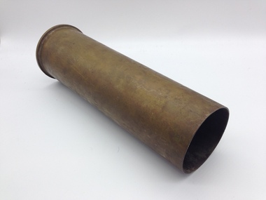 Montmorency/Eltham RSL Sub Branch
Weapon - 6-Pounder Shell Case, E.C.C, 1942
The Ordnance QF 6-pounder (57mm) 7 cwt was a British anti-tank gun used by both British and Commonwealth forces during World War II. Different versions of the gun were used on tanks, armoured cars and naval vessels. One version - the Molins Gun - was even used on an aircraft. Designed to replace the QF 2-pounder (40mm) it was first used by Australian troops during the El Alamein battles in 1942. The guns were also made in Australia by General Motors Holden who produced 615 of them, delivering the first gun in July 1942. The United States Army also adopted it and called it the 57mm Gun M1. Ammunition was primarily armour-piercing but in March 1944 a high-explosive round was introduced. The shell case shown here would have contained a 2.86kg (6lb 5oz) armour-piercing projectile. Brass Shell CaseOn Base of Cartridge: 6PR 7CWT LOT E.C.C. 236 On central firing disc: No. 15 II 11C 41 115 TH 1- -42 7 1942 F. T