Showing 10909 items matching " plans "
-
 Moorabbin Air Museum
Document (Item) - Australian Domestic Flight Notification Instructions - Flight plans
... - Flight plans ... -
Moorabbin Air Museum
Plan (Item) - Assorted plans/schematic drawings RAAF, Assorted plans/schematic drawings
... Assorted plans/schematic drawings ...RAAF -
Moorabbin Air Museum
Document (Item) - KD2R-5 Training Target System Photocopy Of Plans
... KD2R-5 Training Target System Photocopy Of Plans ... -
Moorabbin Air Museum
Document (Item) - Turana General Arrangement Photo Copy Of Plans
... Turana General Arrangement Photo Copy Of Plans ... -
Moorabbin Air Museum
Work on paper (Item) - GAF Nomad, Various plans, drawings and articles on GAF Nomad
... Various plans, drawings and articles on GAF Nomad ...Government Aircraft Factories -
Moorabbin Air Museum
Plan (Item) - Airtrainer CT4 Plans
... Airtrainer CT4 Plans ... -
Moorabbin Air Museum
manual (item) - CAC Atar 9C34 engine plans, ATAR 09C3 Plans
... ATAR 09C3 Plans ...CAC Collection -
Moorabbin Air Museum
manual (item) - CAC SNECMA Avon Engine Miscellaneous Plans
... CAC SNECMA Avon Engine Miscellaneous Plans ...CAC Collection -
Moorabbin Air Museum
Plan (Item) - CAC Plans, Commonwealth Aircraft Corporation Plans Multiple Components
... Commonwealth Aircraft Corporation Plans Multiple Components ...Commonwealth Aircraft Corporation -
Moorabbin Air Museum
Document (item) - CAC Collection - CAC Restructure Plans also Monthly Planning Restructure Reports
... CAC Collection - CAC Restructure Plans also Monthly ... -
Moorabbin Air Museum
Work on paper (item) - CAC Collection Facility Assembly Plans, Facility Assembly Plans
... Facility Assembly Plans ...CAC Collection -
Kew Historical Society Inc
Archive (series) - Subject File, Maps and plans, 1838-1998
... Maps and plans ...Reference, Research, InformationSecondary Values (KHS Imposed Order)Subject file containing a range of maps from different historical periods. Some have newspaper articles with background historical information. Some are maps produced by the MMBW, Members of Parliament, Melways, and hand-drawn maps locating where buildings, people and places were formerly in evidence. -
 Queen Victoria Women's Centre
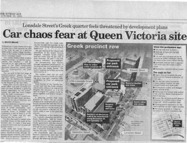
Newspaper excerpt, The Sunday Age, Car Chaos fear at Queen Victoria Site: Lonsdale Street's Greek quarter feels threatened by development plans, 29 October 2000
... Greek quarter feels threatened by development plans. ...Newspaper excerpt from The Sunday Age. Page 5 and a smaller introduction probably from the front page. Smaller excerpt colour photo of blue-stone and cast-iron wall which was to be demolished. Larger excerpt, a black and white aerial view of QVWC and the block where it is situated. building construction, building permits, historic building -
Freemasons Victoria - Southern Cross Lodge No. 24 (Maldon)
Binder, Building Plans
... Building Plans ... -
Beechworth Honey Archive
Book, Plants and planting plans for a bee garden, 2012
... Plants and planting plans for a bee garden ... -
University of Melbourne, Burnley Campus Archives
Plan, Orchard Plans, 1959-1966
... Orchard Plans ...Handwritten and typed roneo copies, with amendments. (1) Apple Block at October 1959. (2) Pear Block at October 1959. (3) Plum Block at 16/5/60. (4) Citrus Block at 1/3/60. (5) Citrus Block at 13/10/60 and Plum-Apricot Block at 8/10/60. (6) Misc. Fruits, Peach, Nectarine, Apricot, Almond & Fig Block at Oct. 1960. (7) Berry Block at 25 Oct 1960. (8) Apple Block at October 1960. Pear Block at October 1960. (9) Citrus Block June 1966. (10) Apple Block June 1966. (11) Quinces, figs, almonds, apricots, peaches. (12) Peach, Nectarine, Apricot, Almond and Fig Block June 1966roneo, fruits, orchards -
University of Melbourne, Burnley Campus Archives
Plan, Plans for courtyards at a hospital. Courtyards 1, 2 and 3; 4; 5 ; 6; Typical Courtyard sections; Functional areas
... Plans for courtyards at a hospital. Courtyards 1, 2 and 3 ... -
University of Melbourne, Burnley Campus Archives
Booklet, Victorian College of Agriculture and Horticulture, Plans for Management of Emergencies V.C.A.H, 10.02.1991
... Plans for Management of Emergencies V.C.A.H. ...vcah, emergencies, evacuation -
 Wodonga & District Historical Society Inc
Album - Ringer's River by Des Martin - Plate 23 - Plans for a ring-in at Nuggety track
... Ringer's River by Des Martin - Plate 23 - Plans for a ...Keiran, Artie Klinberg, and an old horse trainer named Tim Byrne combine to make friends with Grapeshot. Nightly they row across the river, feed him on oats, and train him. Their intention is to ring Grapeshot in for Smokey at the Nuggety Flat meeting where Klinberg will punt him well. Des Martin as Byrne. Lt. Col. Tony Hammett as Klinberg.The album and images are significant because they document literature written by a prominent member of the Wodonga community. The presentation of this precis was supported by several significant district families and individuals.Ringer's River Album Coloured photo Plate 23des martin, many a mile, ringer's river, northeast victoria stories -
Healesville Sanctuary Heritage Centre
Newspaper - Cutting, The Sun News-Pictorial, Melbourne, New Sanctuary Body Plans Rebuilding, 27 June 1949
... New Sanctuary Body Plans Rebuilding ...Mr Pinches states that new committee have plans for rebuilding, after criticism of the enclosure for Tasmanian Devils.photocopynon-fictionMr Pinches states that new committee have plans for rebuilding, after criticism of the enclosure for Tasmanian Devils.1940s -
Healesville Sanctuary Heritage Centre
Newspaper - Cutting, The Herald, Melbourne, Sanctuary Plans For Cabinet, 26 March 1949
... Sanctuary Plans For Cabinet ...Plans for Healesville Sanctuary and appointment of an advisory committee will be discussed by Cabinet. Committee would comprise of not only Government officials but with experts on native animals and birds included.photocopynon-fictionPlans for Healesville Sanctuary and appointment of an advisory committee will be discussed by Cabinet. Committee would comprise of not only Government officials but with experts on native animals and birds included.1940s -
Ringwood and District Historical Society
Container, Carton awaiting cataloguing: Ringwood Library plans and folders with misc. research
... Carton awaiting cataloguing: Ringwood Library plans and ... -
Stawell Historical Society Inc
Archive - Drawings, St Matthews Uniting Church Plans, 20/4/1977
... St Matthews Uniting Church Plans ...Sheet 1 - Line drawing of suggested ideas for interior of St Matthews Presbytery 20/4/1977 Sheet 1A - Organ at South end bet set on ceiling of Narthex set back against wall 20/4/1977 Sheet 1B - Organ at South end but set lower into front wall of glass screen of Narthex 20/4/1977 Sheel 1C - Organ at South end set overhanging front screen of Narthex Screen 20/4/1977 Sheet 2 - Proposed Glorious Cross in Metal, Lead, Glass 20/4/1977Paper in brown cardboard Roll Holderreligion -
Stawell Historical Society Inc
Archive - Blueprint, St Matthew Uniting Church Plans, 12/10/1997
... St Matthew Uniting Church Plans ...Proposed alterations to Uniting Church St Matthews Stawell N.H. Cottman 12/10/1979Paper & Tracing Paper in brown Cardboard roll holderreligion -
Stawell Historical Society Inc
Archive - Blueprint, Methodist Church Main Street Plans, 20/10/1965
... Methodist Church Main Street Plans ...Alterations and additions to Stawell Methodist Church Main Street Earle and Associates Architects 25/10/1965 Job 6455 Drawing 3Paper in brown Cardboard roll holderreligion -
Clunes Museum
Document - PLAN, TITLE PLANS OF GLENGOWER
... TITLE PLANS OF GLENGOWER ...1 PAGE PHOTOCOPY OF MAP OF GLENGOWER3153 G(3) 28 COMPILED AUGUST 1875 COMPARED WITH ORIGINALS 5/6/1965 AND 4/8/1976photo-lithographic, glengower titles plan -
 Warrnambool and District Historical Society Inc.
Document, Plan of Church of Christ Warrnambool, 1883
These plans have been drawn up in 1883 by the Warrnambool architect, William Patterson. They show six sections of plans for the erection of a Church of Christ at 12 Spence Street Warrnambool. The mason was William Kellas and the builder was Harold Dawkins. Church of Christ adherents began meeting in Warrnambool in 1875 and bought land in Spence Street in 1877. The church was opened in 1885 with visiting pastors until a resident minister, A. J. Fisher, was appointed in 1915. This church was closed early in the 21st century when a new church, Gateway Church of Christ, was opened in Ragland Parade in Warrnambool. These plans are of great interest as original ones of the Church of Christ In Spence Street Warrnambool. The plans have come from the present-day Warrnambool Church of Christ. The building still exists but is no longer is use as a church. These are two sheets of cream-coloured thick paper with scaled drawings of plan sections of the Church of Christ in Warrnambool. The drawings are in black ink with some sections coloured in. Both pages have a black line margin drawn around the edges. The pages are torn at the edges in several places and the sheets are much stained. The sheets have been reinforced at the back (left side) with thick brown paper.‘Plan of Christ Church Warrnambool’plans church of christ warrnambool, william kellas, harold dawkins warrnambool -
 Flagstaff Hill Maritime Museum and Village
Document - Plan, Victorian Harbours Warrnambool, Victorian Harbours, Warrnambool, Plan to Accompany Sir John Coode's Report, 28-02-1879
This plan is of great significance to the local history of Warrnambool, in particular the Breakwater and its impact on Warrnambool's maritime and trade history. The plan shows the existing jetties at the Port of Warrnambool, plus the partially erected Breakwater and proposed works to the Breakwater by both the Borough of Warrnambool Surveyor and Sir John Coode. The plan was signed 28th February 1879 by Sir John Coode. The legend at the bottom left describes the existing works and the proposed works. The Warrnambool Breakwater Sir John Coode was a British harbour engineer. He was brought to Melbourne by the Melbourne Harbour Trust to advise on works to improve the Port of Melbourne. The Victorian Government commissioned him to present a plan to complete the Warrnambool Breakwater. His original plan was too expensive so he prepared a revised plan for a shorter structure. The work was completed in 1890. The construction proved to be too short to protect adequately from the weather and didn't allow enough depth for larger vessels to come into port. The decreasing trade was further affected by siltation in the bay due to the breakwater, and the completion of the railway line. The situation of the harbour became a real problem that, by 1910, required continuous dredging. In 1914 the Breakwater was extended but proved to be a failure because the work began to subside and by 1920 about two thirds of the harbour was silted up. Alterations made in the 1920's increased the silting problem and by the 1940's the harbour was no longer used. More alterations were made in the 1950's and 1960's. The Warrnambool Breakwater is registered as a place of significance on the Victorian Heritage Database. This plan of the proposed works for the existing Warrnambool Breakwater is of great significance to the local history of Warrnambool, in particular the Breakwater and its impact on Warrnambool's maritime and trade history. The Warrnambool Breakwater is registered as a place of significance on the Victorian Heritage Database (VHR H2024). It is historically significant to Victoria as one of the most important maritime engineering projects in Victoria in the late 19th century. The Warrnambool Breakwater is of historical significance as one of the most important maritime engineering projects in Victoria in the late nineteenth century. It is evidence of Victoria's nineteenth century investment in regional port infrastructure and the development of Victorian coastal shipping. It is of significance for its association with the English civil engineer Sir John Coode, the most distinguished harbour engineer of the nineteenth century, who was brought to Victoria to advise on works to improve the Port of Melbourne, but was retained by the Government to advise on improvements to the harbours at Portland, Geelong, Port Fairy, and Lakes Entrance, as well as Warrnambool. His projects for Melbourne, Lakes Entrance and Warrnambool were major engineering projects of the nineteenth century. The breakwater is historically significant as a reminder of Warrnambool's early maritime history as a Western District port, and as one of Victoria's major 'outer ports'. While the Warrnambool Breakwater is a demonstration of the engineering skills of the nineteenth century, it also demonstrates the limitations of knowledge relating to sedimentology at the time and the confidence apparent in a number of nineteenth century plans which assumed that natural forces could be overcome or contained by engineering.Plan of Warrnambool Harbour, Port of Warrnambool, dated 28 Feb 1879. Plan shows existing Breakwater and work proposed by both Warrnambool Borough Surveyor and Sir John Coode. Plan has gold coloured quarter-dowel rods top and bottom and a metal ring at the top. Stamped with title. Signed by Sir John Coode.Stamped "VICTORIAN HARBOURS / WARRNAMBOOL / PLAN / to accompany / SIR JOHN GOODE'S REPORT / DATED 28 FEB 1879" Signature "John Coode"flagstaff hill, warrnambool, maritime museum, shipwreck coast, great ocean road, sir john coode, borough of warrnambool surveyor, plan of warrnambool, victorian harbours, warrnambool harbour, warrnambool breakwater, port of warrnambool, vhd vhr h2024, flagstaff hill maritime museum & village, maritime village, map, chart, plan, lady bay, breakwater, jetty, pier, vhr h2024, proposed works, 1879 -
 Bendigo Historical Society Inc.
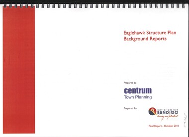
Book - EAGLEHAWK STRUCTURE PLAN BACKGROUND REPORTS, 2011
Eaglehawk Structure Plan Background Reports, 5 reports in 2 volumes identifying a broad range of findings to guide future strategis planning in Eaglehawk, with maps photographs and graphs. Prepared for City of Greater Bendigo: Reports 1 & 2 prepared by Centrum Town Planning (5756a) Reports 3, 4 & 5 prepared by Traffic Works (5756b)Centrum Town Planningbendigo, council, eaglehawk structure plan -
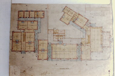 Kew Historical Society Inc
Slide - Architectural Drawing, Kew Public Offices, 1887
A civic campaign for new public offices developed in Kew in the 1880s. After much deliberation, the location chosen was the junction of Bulleen and Cotham Roads. The buildings were designed by George Watson and John Henry Harvey, architects within the Department of Public Works (Victoria). Building was commenced in 1887, and after one year, the buildings were opened. The Post Office was transferred to the new Commonwealth Government in 1901. The Police Station and Court House, sold by the Victorian Government to the City of Boroondara in 2007, are now a community cultural centre and performing arts venue.The buildings were listed on the Victorian Heritage Register Register (HO885) in 1991. They are historically and architecturally significant to the State Of Victoria because Watson and Harvey's designs exhibit diversity in integrating civil offices, they accommodate the apex of road junctions, and they demonstrate a departure from the contemporaneously favoured High Victorian Classical to the Queen Anne style in the design of civic buildings. 35mm colour transparency of an original plan by George Watson and John Henry Harvey, architects of the Department of Public Works (Victoria), in 1887 for New Public Offices at Kew. This plan was copied by the donor from an original held at the Commonwealth Archives in Brighton (Vic). The copy was made to illustrate a report that the donor made on ‘The functional planning design, building materials and construction methods of the Kew Post Office’ as part of course work at RMIT.GROUND PLANkew court house, kew police station, kew post office, architectural drawings, khs - slides, new public offices — kew (vic.), architecture — queen anne style