Showing 110536 items
matching roads
-
 Ringwood and District Historical Society
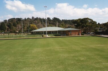
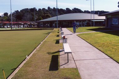
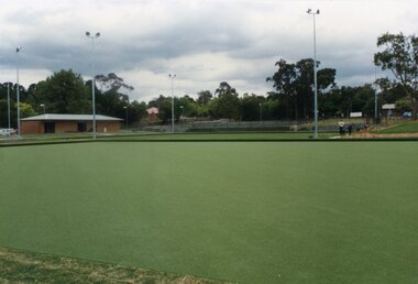
Photograph, Ringwood Bowls Club - New club house and greens at the corner of Warrandyte and Loughnan Roads, 1997. Photo taken by Jim Bennett
... corner of Warrandyte and Loughnan Roads, 1997. Photo taken by Jim ...Coloured photograph -
 Ringwood and District Historical Society
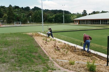
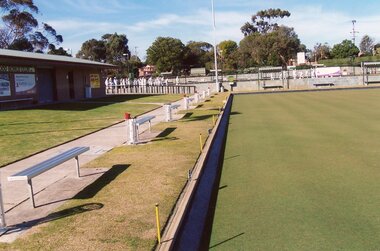
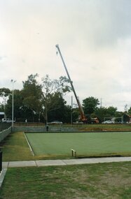
Photograph, Ringwood Bowls Club - New club house and greens at the corner of Warrandyte and Loughnan Roads, 1997. Photo taken by Jim Bennett
... corner of Warrandyte and Loughnan Roads, 1997. Photo taken by Jim ...Coloured photograph -
 Ringwood and District Historical Society
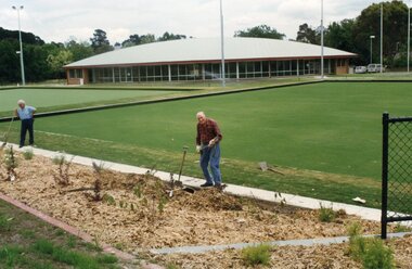
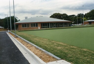
Photograph, Ringwood Bowls Club - New club house and greens at the corner of Warrandyte and Loughnan Roads, 1997. Photo taken by Jim Bennett
... corner of Warrandyte and Loughnan Roads, 1997. Photo taken by Jim ...Coloured photograph -
 Ringwood and District Historical Society
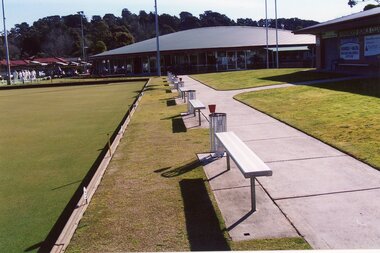
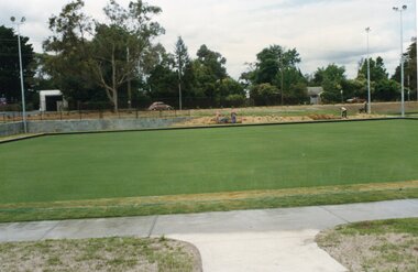
Photograph, Ringwood Bowls Club - New club house and greens at the corner of Warrandyte and Loughnan Roads, 1997. Photo taken by Jim Bennett
... corner of Warrandyte and Loughnan Roads, 1997. Photo taken by Jim ...Coloured photograph -
 Ringwood and District Historical Society
Photograph, Ringwood Bowls Club - New club house and greens at the corner of Warrandyte and Loughnan Roads, 1997. Photo taken by Jim Bennett
... corner of Warrandyte and Loughnan Roads, 1997. Photo taken by Jim ...Coloured photograph -
 Ringwood and District Historical Society
Photograph, Ringwood Bowls Club - New club house and greens at the corner of Warrandyte and Loughnan Roads, 1997. Photo taken by Jim Bennett
... corner of Warrandyte and Loughnan Roads, 1997. Photo taken by Jim ...Coloured photograph -
 Ringwood and District Historical Society
Photograph, Ringwood Bowls Club - New club house and greens at the corner of Warrandyte and Loughnan Roads, 1997. Photo taken by Jim Bennett
... corner of Warrandyte and Loughnan Roads, 1997. Photo taken by Jim ...Coloured photograph -
 Ringwood and District Historical Society
Photograph, Ringwood Bowls Club - New club house and greens at the corner of Warrandyte and Loughnan Roads, 1997. Photo taken by Jim Bennett
... corner of Warrandyte and Loughnan Roads, 1997. Photo taken by Jim ...Coloured photograph -
 Ringwood and District Historical Society
Photograph, Ringwood Bowls Club - New club house and greens at the corner of Warrandyte and Loughnan Roads, 1997. Photo taken by Jim Bennett
... corner of Warrandyte and Loughnan Roads, 1997. Photo taken by Jim ...Coloured photograph -
 Ringwood and District Historical Society
Photograph, Ringwood Bowls Club - New club house and greens at the corner of Warrandyte and Loughnan Roads, 1997. Photo taken by Jim Bennett
... corner of Warrandyte and Loughnan Roads, 1997. Photo taken by Jim ...Coloured photograph -
 Victorian Railway History Library
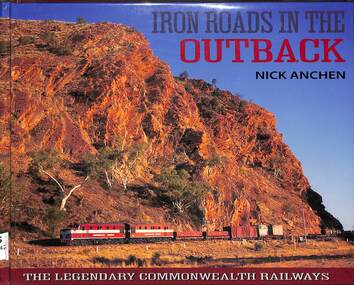
Book, Nick Anchen, Iron Roads in the Outback, 2017
... Iron Roads in the Outback ...The Iron Roads of the Australian Outback - the legendary Commonwealth Railways were built through some of the harshest landscapes on Earth. They were railways like no other, where men and women battled extreme temperatures, flash floods and maddening isolation to keep the trains running. This publication is the culmination of 25 years of Outback exploration, research, photography and interviews by author Nick Anchen. The result is a diverse book which brings to life both the beauty and harshness of the Australian Outback, through a collection of fascinating and historic images, along with the memories of former Commonwealth Railways employees. Following an introductory chapter on the vastness and grandeur of the Australian interior - highlighted by the memoirs of 1950s flying doctor Macarthur Job - the book delves into the story of the Central Australia Railway. This was the line built through the 'back of beyond' - the forbidding desert country of South Australia and the Northern Territory. It was here that operators of famous trains such as The Ghan battled searing heat, dust storms and raging floodwaters to keep the trains running. The chapter includes stories by well known Ghan conductor 'Aspro' Lyons, and 'Piano Playing Chef' Paddy Greenfield - along with enginemen Wolf Markowski and John Theel, both of whom worked trains on this famous railway. The story of the North Australia Railway - 'The Line to Nowhere' - is the tale of a ramshackle railway which came alive during the dark days of World War II. The memoirs of wartime engineman Jim Prentice are eye opening, as are the hair raising accounts of surviving Tropical Cyclone Tracy, as told by rolling stock foreman Bill Donaldson. The Trans-Australian Railway was built across one of the harshest and loneliest environments on Earth - the vast Nullarbor Plain. Stories from enginemen Jack Slattery and Ron Howrie, along with Nullarbor resident and roadmaster's wife Cathy Beek, tell not only of the rudimentary living conditions and maddening isolation, but of the great camaraderie amongst the railway people who kept trains such as the Trans-Australian and the Tea and Sugar running. As well as examining the ruins and relics from the long-closed CR narrow gauge lines, the book also includes a chapter on the much-loved Pichi Richi Railway - the last surviving portion of that great Transcontinental Railway dream from another age.ill, maps, p.208.non-fictionThe Iron Roads of the Australian Outback - the legendary Commonwealth Railways were built through some of the harshest landscapes on Earth. They were railways like no other, where men and women battled extreme temperatures, flash floods and maddening isolation to keep the trains running. This publication is the culmination of 25 years of Outback exploration, research, photography and interviews by author Nick Anchen. The result is a diverse book which brings to life both the beauty and harshness of the Australian Outback, through a collection of fascinating and historic images, along with the memories of former Commonwealth Railways employees. Following an introductory chapter on the vastness and grandeur of the Australian interior - highlighted by the memoirs of 1950s flying doctor Macarthur Job - the book delves into the story of the Central Australia Railway. This was the line built through the 'back of beyond' - the forbidding desert country of South Australia and the Northern Territory. It was here that operators of famous trains such as The Ghan battled searing heat, dust storms and raging floodwaters to keep the trains running. The chapter includes stories by well known Ghan conductor 'Aspro' Lyons, and 'Piano Playing Chef' Paddy Greenfield - along with enginemen Wolf Markowski and John Theel, both of whom worked trains on this famous railway. The story of the North Australia Railway - 'The Line to Nowhere' - is the tale of a ramshackle railway which came alive during the dark days of World War II. The memoirs of wartime engineman Jim Prentice are eye opening, as are the hair raising accounts of surviving Tropical Cyclone Tracy, as told by rolling stock foreman Bill Donaldson. The Trans-Australian Railway was built across one of the harshest and loneliest environments on Earth - the vast Nullarbor Plain. Stories from enginemen Jack Slattery and Ron Howrie, along with Nullarbor resident and roadmaster's wife Cathy Beek, tell not only of the rudimentary living conditions and maddening isolation, but of the great camaraderie amongst the railway people who kept trains such as the Trans-Australian and the Tea and Sugar running. As well as examining the ruins and relics from the long-closed CR narrow gauge lines, the book also includes a chapter on the much-loved Pichi Richi Railway - the last surviving portion of that great Transcontinental Railway dream from another age. commonwealth railways (australia) -- history., central australia railway -- history. -
 Surrey Hills Historical Society Collection
Work on paper - Vertical file, Boroondara Roads Board
... Boroondara Roads Board ...1. History notes 1841-1864 from Alan Holt, undated (1 page). -
 Phillip Island and District Historical Society Inc.
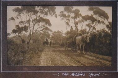
Photograph, Hay carting, The Nobbies Road, Phillip Island, c 1913
Unmade road through bush and trees. One white horse and one black horse pulling cart loaded with hay. Two hatted men seated on top of hay. A rider on horseback with stock in background. Very rural scene.Carting hay on Nobbies RoadThe Nobbies Roadlocal history, photographs, the nobbies road, sepia photograph, betty kus collection, rural scene, phillip island, bruce bennett -
 Whitehorse Historical Society Inc.
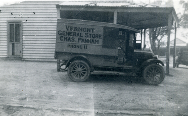
Photograph, Pannam's General Store
... Vermont, Canterbury & Boronia Roads. ...Part of The Shambrook Collection for 'This is Vermont', not used.Black and white photo of Chas. Pannam's General Store on corner of Canterbury and Boronia Roads, Vermont,(South-East corner), showing front of Delivery Truck.pannam's store, pannam, charles., shambrook, tim -
 Whitehorse Historical Society Inc.
Photograph, Pannam's Store & Truck, 10/05/2000 12:00:00 AM
... Vermont, Boronia & Canterbury Roads ...Part of The Shambrook Collection for 'This is Vermont'.Black and white photo of Chas. Pannam's General Store, South-East corner of Boronia and Canterbury Roads, Vermont. Pannam's Delivery Motor Truck also in photo.pannam's store, pannam, charles, shambrook, tim -
 City of Kingston
Photograph - Black and white, c. 1950
... Roads ...While the road is sealed, there is evidence of potholes that have been filled, and the wide, gravel shoulder has long grass running into the gutter of the nature strip. On the other side of the road, extremely long grass can be seen growing on the side of the road. There is a truck visible on the road, which indicates the rural nature of the Cheltenham community in the 1950s.This image is one of many in the collections that focuses on the railway or roads. The development of roads and the railway was crucial to the ongoing development of the area. Black and white photograph of the intersection of Warrigal and Centre Dandenong roads, Cheltenham. On the left hand side is a small sign warning of a cross roads intersection. Housing and shops line the road.Handwritten in blue ink on reverse: 219 Handwritten in red ink on reverse: 80%cheltenham, roads, suburbs -
Glen Eira Historical Society
Drawing - Thomson Memorial Presbyterian Church Ormond, Jubilee - - 1953: The Jubilee History of the Thomson Memorial Presbyterian Church
... North & Booran Roads, Ormond, Victoria, Australia ...Two documents about this Church: 1/ a pamphlet that describes the jubilee history of Thomson Memorial Presbyterian Church Ormond, 1953, with the history actually dating from 1892. The cover has an illustration of the church and the contents include a list of office bearers in 1953 as well as significant people over the years. Different addresses for it are recorded. 2/ Also a typed page with the description of wording used on the foundation stones at the church (1939) and at the hall (1923).Small paper booklet of 10 pages (beige-coloured) plus front and back cover with a sketch of the church corner of North and Booran Roads Ormond which measures 100mm x 70mm on front cover.presbyterian, ormond, jubilee, north road, booran road, foundation stone, thomson memorial, presbyterian, church, churches, centre road, saint cuthberts, flynn john dr rev., chalinor john p rev., jones hugh rev., balfour graham h. rev., beattie james rev., chisholm farquar rev., hadley vincent f rev., owen j. e. rev, george fincham & sons, building committee, manse, home missionary, pipe organ, thomas street, jasper road, huntly street, brighton east, ulster creek, whitmuir road, merton hall, mulua street, wheatley road, ocean street, cadby hall, plaza theatre, mentone rsl, hadley v.f. rev. b.a. minister, anderson v. mr, box h. mr, curtis r. mr, inglis j. mr, jackson f. mr, lang r. mr, paterson g. mr, ponsford d. mr, porter l. mr, reynoldson a. mr, stevenson d. mr, shallcross h. mr, towers h. mr, viccars r. mr, wade r. mr, williamson w. mr, ponsford d.w. mr, anstee r. mr, box f. mr, mac cleland r. mr, davis a. mr, denton o.w. mr, ferguson a. mr, johnston l. mr, lawrence a. mr, mckerral w. mr, noblet n. mr, sinclair w. mr, taylor s. mr, whitby n. mr, wickenton d. mr, wilson h. mr, warby h. mr, wyatt r. mr, porter lance mr, wade r. mr, wilson d. mr, anderson v. mr, wallace r.a.f. mr, beresford f.j. mr, jackson f. mr, thomson j. mr, henderson a. mr, newham c. mr, arnold a.t. mr, mckerral j. mr, smith e.b. mr, roberts j.h. mr, thomson j. mr, uniting church ormond, 264 booran road, the manse, 428 north road, chinese community, ormond presbyterian church, sutherland family, market gardens, elster creek, sunday schools, malua street, louis r williams architect, norman taylor builder -
 Marysville & District Historical Society
Photograph (Item) - Black and white photograph, c1940s
A black and white photograph of the Marysville-Buxton Road in Marysville in Victoria.A black and white photograph of the Marysville-Buxton Road in Marysville in Victoria. This road leads from Murchison Street, which is the main street, in Marysville in Victoria.Buxton Roadmarysville-buxton road, marysville, victoria, murchison street -
 Uniting Church Archives - Synod of Victoria
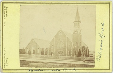
Photograph, Undated c.1880
The Wesleyan Church was located at the corner of Burwood Road and William St. Hawthorn. It was designed by Messrs. Crouch and Wilson. The foundation stone was laid by the Hon. Alexander Fraser MLC on 14 August 1867. The Sunday School next to the church was built in 1878.Sepia carte de visite photograph of the Wesleyan Methodist Church located at the corner of Burwood Road and Williams Street Hawthorn.Burwood Road, Williams Roadwesleyan church, hawthorn, crouch and wilson, hon. alexander fraser -
 Surrey Hills Historical Society Collection
Photograph, Fred Ambler and Family
... Cnr. Union And Sunbury Roads, Surrey Hills, Victoria ...Fred Ambler and family at Albert Mills Premier Land Agency building on the corner of Union and Sunbury Roads, c.1910. Fred had his carpenter and upholstery business on the ground level and his home above. (No.1) Premier Land Agency Building, was built in 1886-7 by Albert Mills, builder, at 122 Union Road, on the corner of Sunbury Crescent, opposite the Railway Station. Photo shows his wife and family. Alfred died in 1890 and the family moved. The Boroondara Standard in 1888 reported: "Splendid block of brick buildings reaching completion in Union Road adjacent to railway line – 2 storey. Frontage 120 feet for Premier Land Agency. Shops at Ground Level." A sepia coloured photograph of a two storey terrace building with 3 ladies and 2 children standing on the balcony. Downstairs, a gentleman stands outside the shopfront beside two prams. There is a child in one pram.albert mills premier land agency building, (mr) fred ambler, union road, carpenter, upholsterer, sunbury crescent -
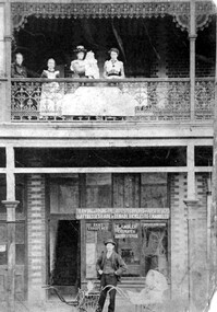
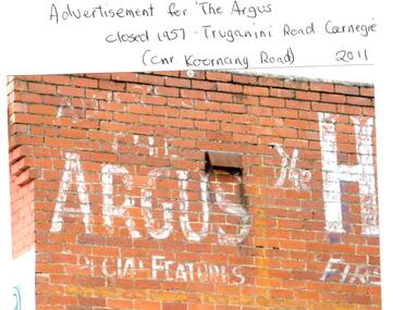 Glen Eira Historical Society
Photograph - CARNEGIE
... Corner Koornang and Truganini Roads, Carnegie, Victoria ...24 photographs relating to Carnegie plus 1 slide: 1/Two photographs, one of Koornang Road c.1920’s and one of flower shop rear of library, date unknown. 2/One photograph of Carnegie Post Office c. undated. 3/Two photographs Koornang Road, Carnegie and phone boxes, Carnegie, dated 1914. 4/Two photographs (the same) of an RSL Ball dated 15/08/1937. 5/17 black and white negative photos – reprinted, date unknown, of Carnegie Library, shop front opening Koornang Road. 6/Slide showing Koornang Road, Carnegie looking South. 7/6 photocopied postcards from Valentines Real Photo Series, in album owned by Mrs. Zoe Mason, collected and returned to Pam Speedy (daughter) 12 Wattle Grove, East Malvern, 15/03/1999. Photocopied pages from 1923 Sands and McDougalls included with some prints to give an idea of architecture and other retail trade. 8/Two photocopied prints of Carnegie Flood. 1946 – Koornang Road, shows shopkeepers in street at that time. 9/Two photographs of brick wall advertising the "Argus" newpaper, which closed in 1957. Photos taken in 2011 when building was exposed prior to rebuilding on site.koornang road, rosstown road, carnegie, shepparson street, carnegie library, carnegie post office, mcallister b., glen huntly, glenhuntly, phone boxes, memorial hall, bamfield m., tranmere avenue, carnegie railway station, stations, libraries, post offices, memorial hall carnegie, progress hall, carnegie community singing, social clubs, chadstone progress, newspapers, temminghoff robert, carnegie chamber of commerce, caulfield city council, rob’s chocolate box, rosstown, ross william murray, rosstown railway, elsternwick, oakleigh, city of caulfield, glen huntly road, glenhuntly road, grange road, carnegie primary school, primary schools, murrumbeena, neerim road, dandenong road, koornang park, lord reserve, rosanna street reserve, packer oval reserve, caulfield swim centre, holywood grove, mile end road, mcpherson avenue, munster avenue, rosstown hotel, leila road, methodist church, toolambool street, carnegie theatre, carnegie estate agency – sims and broadbent, woorayl street, estate agents, cowie j. mrs., confectioner, woodhouse e., stationer, mckay jno. a., mckay jonathon, small goods, perry w. b., chemists, kinsman e. h., newsagents, jones a. w., mckee wm., furniture stores, neil geo. m., grocer, truganini road, brick -
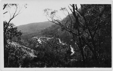
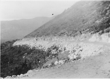 Halls Gap & Grampians Historical Society
Photograph - B/W, C 1927
... Roads ...New road approaching Wirranatwa GapRoad through Mirranatwa Gap with people walking???access routes, mirranatwa gap, roads -
Glen Eira Historical Society
Letter - Hart Family
... Bambra & Neerim Roads, Caulfield, Victoria, Australia ...Handwritten letter from Rodney Hart to Mr Ballantyne, Secretary of the Caulfield Historical Society donating a photograph of his grandfather John Hart and family in from of their Bambra Road house, letter dated 07/03/1984. Includes a black and white photograph with verso description “ John Hart’s home Bambra/Neerim Road, Caulfield 1858 L-R John Hart, wife Mary, mother Susannah. [Date incorrect: John married Mary in 1864, Susannah died in 1875 so it is most likely dated 1870s]hart rodney, hart john, hart mary, hart susannah, ballantyne r, caulfield historical society, bambra, neerim road, caulfield, brick houses, architectural styles -
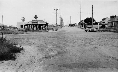
 City of Kingston
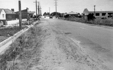
Photograph - Black and white, c. 1950
... Roads ...This image highlights the rural nature of the area during the 1950s where areas that are now major highways and intersections appear like country roads.Black and white photograph of the intersection of Warrigal Road and Centre Road in Oakleigh. There is a truck travelling south toward the camera along Warrigal Road which is a sealed road. On the right hand side is a Caltex petrol station with a street sign for Centre Road.Handwritten in blue ink on reverse: 2191 Handwritten in red ink on reverse: 72%oakleigh, cars, roads, suburbs -
 Marysville & District Historical Society
Photograph (Item) - Black and white photograph, c1940s
A black and white photograph of the Marysville-Buxton Road in Marysville in Victoria.A black and white photograph of the Marysville-Buxton Road in Marysville in Victoria. This road leads into Murchison Street, which is the main street, in Marysville in Victoria.Buxton road Crossways in back/ groundmarysville-buxton road, marysville, victoria, murchison street -
 Halls Gap & Grampians Historical Society
Postcard - Sepia, C 1920s
... Roads ...The road winding up Stoney Creek Gorge with Elephant Hide, the rocky slope in the picture, on the left. Sections of the earlier 19th century bridal track, which was later widened to become a jinker track, can be seen above the new road.Postcard shows Mt Victory Rd unsealed Elephant's hide on leftPostcard Correspondence Address only Kodak Mt Vic Roadaccess routes, mt victory rd, roads -
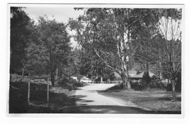
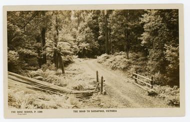 Mt Dandenong & District Historical Society Inc.
Photograph, The Road to Sassafras. Victoria
Rose Series postcard # P. 1588 showing a view of the road to Sassafras pre WW1.Sepia Coloured Rose Series post card P.1588 showing a stretch of unmade road passing over a simple bridge on the road to sassafras.On Front: THE ROSE SERIES, P. 1588 THE ROAD TO SASSAFRAS, VICTORIArose series, postcard, sassafras, road -
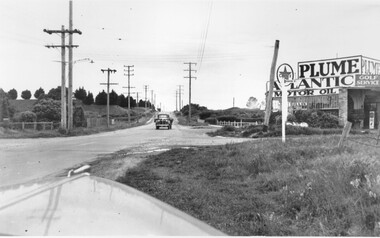
 City of Kingston
Photograph - Black and white, c. 1950
... Roads ...The intersection of Warrigal Road and Nepean Highway is now a major intersection, serviced by traffic lights. In the 1950s it was a joining of two sealed roads, although covered in gravel, and with wide gravel shoulders. There are no traffic signs and the few houses visible are not set very far back from the road. This image is one of many in the collections that focuses on either roads or the railway. The development of roads and the railway was crucial to the ongoing development of the area.Black and white photograph of the intersection of Warrigal Road and Nepean Highway, Mentone. Handwritten in blue ink on reverse: 218 Handwritten in red ink on reverse: 75%mentone, roads, suburbs -
 Whitehorse Historical Society Inc.
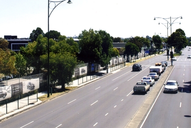
Photograph, Whitehorse Road, Blackburn, 2012
... roads ...The property on the left of Whitehorse Road was once the Cottees factory. It later became the Leader Newspaper headquarters. It was next owned by Lexus Motor Sales and is now used (2014) as a storage yard with the eastern end used by Leader Newspaper as a staff car park.Coloured photograph of Whitehorse Road, Blackburn - 2012. Cars waiting to turn right into Surrey Road.whitehorse road, blackburn, roads -
Stawell Historical Society Inc
Map, R.O. Robson - Authorised Surveyor, Road from Glenorchy to near Geary's Selection Callawaddy 1880, 29.04.1880
Survey for Road CreationCloth Backed Map. Plan of Road.Parishes of Richella & Callawadda. County of Borong. Plan of Road. R.O. Robson Authorised Surveyor Stawell 29.04.80