Showing 40723 items
matching roads and streets
-
 Marysville & District Historical Society
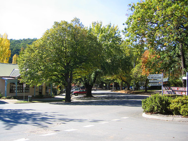
Photograph (Item) - Colour photograph, Travel Victoria, 2006
A colour photograph of Murchison Street in Marysville in Victoria.A colour photograph of Murchison Street in Marysville in Victoria. Shows the view looking down Murchison Street from Pack Road. The buildings that can be seen in the photograph were all destroyed in the 2009 Black Saturday bushfires.murchison street, pack road, marysville, victoria, photograph, 2009 black saturday bushfires -
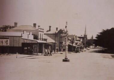 Glenelg Shire Council Cultural Collection
Photograph - Photograph - street scene, Portland, n.d
Photograph showing a street scene. There is a church spire in the background and a group of 3 people crossing the street. There is a monument in the middle of the road. -
 Eltham District Historical Society Inc
Photograph, Street near Eltham
Main Road Eltham looking south from opposite John Street towards Pitt Street showing Eltham Hotelmain road, pitt street, eltham, hotels -
 Port Melbourne Historical & Preservation Society
Plan - Williamstown Road from Salmon Street to Prohasky Street, Engineering Department, Town of Port Melbourne, 1893 - 1919
Plan of Williamstown Road (Reconstruction of pitched portion). From Salmon Street to Prohasky Street. 1893 Loan Number 5.Reverse side - Williamstown Road, west of Salmon (Pitcher Construction).engineering - roads streets lanes and footpaths -
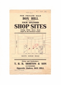 Whitehorse Historical Society Inc.
Document, Shop Sites, 1922
Notice of private sale of four shop sitesNotice of private sale of four shop sites in Whitehorse Road, Box Hill between Watt Street and Court Street.Notice of private sale of four shop sitest. r. b. morton & son, whitehorse road, box hill, court street, watt street -
 Ringwood and District Historical Society
Flyer, Land Sale Brochure, Heathmont Estate, Vic. - circa 1960
Advertisement for sale of residential lots - Heathmont Estate, opposite Heathmont Railway Station, with map and locality plan.Subdivision includes Canterbury Road, Royal Avenue, Coleman Street, Stoda Street, Herman Street, and Campbell Street. Agent - A.W. Dickson, opposite Station, Ringwood. Phone WU6007. -
 Ringwood and District Historical Society
Administrative record - Rate Books, Borough of Ringwood Valuation & Rate Cards for 1944-49 (Assessments 3193-3197), March 2012
Originally stored at Ringwood Council offices, then taken to PROV.Only source of ratepayers in the Borough of RingwoodDigital imagesFor BR Stewart (Belgrave Road), Violet Sampson (Barkly Street), Margaret Cowin (Barkly Street), Edith Phillips (Barkly Street) & Arthur George (Barkly Street, Allman's Estate). -
 Whitehorse Historical Society Inc.
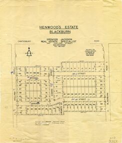
Map, Henwoods Estate, Blackburn
Plan of subdivision in Blackburn SouthPlan of subdivision in Blackburn South between Holland Road and Blackburn Road. Estate advertised by Spencer Jackson, 341 Collins Street.Plan of subdivision in Blackburn South land subdivision, henwoods estate, blackburn south, holland road, brazeel street, marama street, blackburn road, gissing street, hearty street -
 Camberwell Historical Society
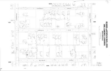
Map (Item) - MMBW map, Melbourne and Metropolitan Board of Works, Melbourne and Metropolitan Board of Works - Shire of Boroondara and Camberwell - Detail Plan no. 1845, August 1904
Lithographer JEM, exd. JWD, June 1904, no. 71. 40P.15W.melbourne and metropolitan board of works, map, camberwell, cartography -
Canterbury History Group
Photograph - Street view looking north up Maling Road including the shop signs of Brittany Cake Shop at No. 114, Milton's at No. 116 and Simple Solutions at No.118, Jan Pigot, 27/03/1993 12:00:00 AM
Coloured photograph of the street view of Maling Road looking north towards Canterbury Road with Shop 114 , 116 and 118 in view.canterbury, maling road, shops, wunderlite pressed metal ceilings, street signs -
 Whitehorse Historical Society Inc.
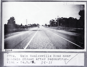
Photograph, Main Healesville Road 1938, 24/05/1938 12:00:00 AM
Black and white photograph of main Healesville Road (Whitehorse Road) near Goodwin Street, Blackburn after road construction on 24 May 1938. Other Number 3724healesville road, blackburn, goodwin street, blackburn., whitehorse road -
University of Melbourne, Burnley Campus Archives
Map, Drainage & Contours City of Hawthorn, c. 1970
Copy of map with some coloured and pencil annotations. Scale 1:2000. Marked "2". Area bounded by Glenferrie Road, Power Street, Barkers Road, Burwood Roadhawthorn, glenferrie sports ground, grace park, contours -
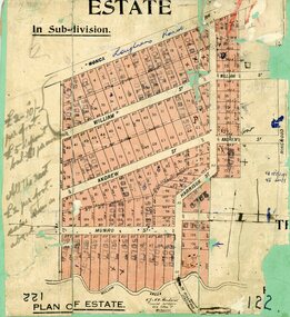 Ringwood and District Historical Society
Map, Subdivision Plan, Loughnans Road, Ringwood - circa 1922
Green card with cut-out map of residential allotments, some marked "sold". "Plan of Estate" includes Wonga Road, Loughnans Road, William Street, Andrew Street, Harrison Street, and Munro Street, Ringwood. (Surrounding area is part of Ringwood Park Estate featured in seperate 1922 auction flyer).Handwritten notations - (northern section) {£2-10/- per foot. £5 deposit bal £1 per month} All the rest £2 per foot, value same as above. Licensed Surveyors - W.J. & A.W. Kenhardt, 352 Collins Street, Melbourne. -
 Ringwood and District Historical Society
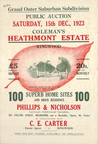
Flyer, Land Sale Brochure, Coleman's Heathmont Estate, Ringwood, Vic. - 1923
Bi-fold advertisement for auction sale of residential sites, including photographs, map, and summary of subdivision features and local facilities. Auction date Saturday 15th December, 1923. Subsequent auction date Saturday 19th January, 1924, following previous sale stopped on account of rain. Initial newspaper advertisement (publication unknown) dated 16/11/23.Subdivision includes Bedford Road, Canterbury Road, Alvena Crescent, Leonard Street (later Royal Avenue), and Coleman Street. Agent - Phillips & Nicholson, 281 Collins Street Melbourne, (Phone) Central 10907, in conjunction with C.E. Carter, Main Street, Ringwood. Tel. Ringwood 24. -
 Kew Historical Society Inc
Plan - Subdivision Plan, Boulevard Estate - Boulevard Section, 1930-1936
Pru Sanderson, in her groundbreaking ‘City of Kew Urban Conservation Study : Volume 2 - Development History’ (1988), summarised the periods of urban development and subdivisions of land in Kew. The periods that she identified included 1845-1880, 1880-1893, 1893-1921, 1921-1933, 1933-1943, and Post-War Development. These periods were selected as they represented periods of rapid growth or decline in urban development. An obvious starting point for Sanderson’s groupings involved population growth and the associated economic cycles. These cycles also highlighted urban expansion onto land that was predominantly rural, although in other cases it represented the decline and breakup of large estates. A number of the plans in the Kew Historical Society’s collection can also be found in other collections, such as those of the State Library of Victoria and the Boroondara Library Service. A number are however unique to the collection.The Kew Historical Society collection includes almost 100 subdivision plans pertaining to suburbs of the City of Melbourne. Most of these are of Kew, Kew East or Studley Park, although a smaller number are plans of Camberwell, Deepdene, Balwyn and Hawthorn. It is believed that the majority of the plans were gifted to the Society by persons connected with the real estate firm - J. R. Mathers and McMillan, 136 Cotham Road, Kew. The Plans in the collection are rarely in pristine form, being working plans on which the agent would write notes and record lots sold and the prices of these. The subdivision plans are historically significant examples of the growth of urban Melbourne from the beginning of the 20th Century up until the 1980s. A number of the plans are double-sided and often include a photograph on the reverse. This plan shows a subdivision with two sections: the ‘Boulevard Section’ and the ‘Riverside Section’. The first of these sections bordered Burke Road between Kilby Road and the farm beside the Yarra. Kilby Road, Munro Road, Burke Road and Old Burke Road bordered the 102 lots in the Boulevard Section of the plan. The streets within the Section included Walbundry Avenue, Inverness Way, Riverside Avenue, Cascade Street and Kyora Parade. These street names, at least in this subdivision plan linked the two Sections of the subdivision. At a later date, the City of Kew decided to alter the street names. Walbundry, Inverness, Riverside, Cascade and Kyora were all renamed as ‘Drives’ (e.g. Kyora Drive). The subdivision plan is of interest in that it names High Street in Kew as Doncaster Road. It also shows the location of the wooden church that was later removed to Yarraville on the corner of Kilby Road and High Street. The plan predates later developments such as the S. E. Dickens Supermarket.subdivision plans - east kew, boulevard estate, munro road -- kew east (vic.), kilby road -- kew east (vic.), burke road -- kew east (vic.), walbundry avenue -- kew east (vic.), inverness way -- kew east (vic.), riverside avenue -- kew east (vic.), cascade drive -- kew east (vic.), nyora parade -- kew east (vic.) -
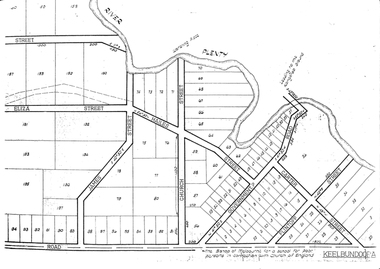 Greensborough Historical Society
Maps, Greensborough. Parish Plan 1860, 1860c
This plan show Green's subdivision of Greensborough, north of Grimshaw Street.Enlargements of Parish plan circa 1860?One copy possibly from 1860, containing lot numbers for a government road, now Main Street, and surrounding streets.greensborough, grimshaw street greensborough, edward bernard green -
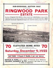 Ringwood and District Historical Society
Flyer, Sub-divisional auction sale advertisement - Ringwood Park Estate, Ringwood, Vic. - 1922
Folded double-sided page with black and white photographs of local views with black and red print advertising auction sale on Saturday 9th December, 1922, - 70 residential home sites, including terms of sale, locality map, and description of local facilities and services. Subdivision includes Wonga Road (later Loughnan Road), William Street, Andrew Street, and Harrison Street. Vendors Solicitors - Rigby & Fielding, 60 Market Street, Melbourne. Estate Agents - Keogh & King, 70 Elizabeth Street, Melbourne, Telephone 6938. Auctioneer - Cranny, Sambell & Co., 325 Collins Street, Melbourne, Telephone Central 5067 and 5077. -
 Bacchus Marsh & District Historical Society
Map, Gaynor Street Area Land Sales, Maddingley, 1888
This map was produced for a major sale of land in the Maddingley area of Bacchus Marsh in 1888. The sale was conducted by two firms from Melbourne, Carney and Kelly 12 Swanston Street Melbourne. and 'Richardson, Kerr & Co. 40 Flinders Lane Melbourne. 136 blocks were for sale.A single page paper map showing land allotments for sale in the Maddingley area of Bacchus Marsh. Locations shown include Gaynor Street, Maddingley Road South, Parwan Road, Mitchem Street, Typpynge Street, Finn Street and East Maddingley Road. . The map is pasted into a bound volume containing 76 maps or plans in total. High resolution digital image stored on BMDHS computer network. bacchus marsh victoria maps, maddingley victoria maps, land use, maddingley victoria history, land sales bacchus marsh, land sales maddingley -
 Bacchus Marsh & District Historical Society
Map, Gaynor Street Land Sales, Maddingley, circa 1880s-1890s
This map was produced for a major sale of land in the Maddingley area of Bacchus Marsh. The precise date of the sale has not been determined. Features present on the map such as the Bacchus Marsh Railway Station indicate the land sale must have taken place some time after 1887 when the Railway Station opened. A single page paper map showing land allotments for sale in the Maddingley area of Bacchus Marsh. Locations shown include Gaynor Street, Maddingley Road South, Parwan Road, Mitchem Street, Typpynge Street, Finn Street and East Maddingley Road. . The map is pasted into a bound volume containing 76 maps or plans in total. High resolution digital image stored on BMDHS computer network. bacchus marsh victoria maps, maddingley victoria maps, land use, maddingley victoria history, land sales bacchus marsh, land sales maddingley -
 Kew Historical Society Inc
Photograph, Stuart Tompkins Studio, Electricity Supply Poles, South Road, Moorabbin, 1965
Research provided by Stuart Tompkins Studio, Box Hill, into alternatives for median strip street lighting to be used in Burke Road, Kew. The photographers identified variants in different suburbs appropriate to Kew's needs.The series from which the photograph is drawn provides a snapshot by a commercial photographic studio of each named vicinity in 1965 as well as providing examples of public works infrastructure being commissioned by local government in the 1960s. The photos originally formed part of the Engineering Department's files in the City of Kew before being donated to the kew Historical Society.Electricity Supply Poles, South Road, Moorabbin, 1965. Stuart Tompkins Studio provided this photograph for the Kew City Council. The photograph of South Road, Moorabbin, west of Jasper Road, looking east depicts steel poles with two lamps in a median strip and supply wires from pole to pole. The poles were described as 100′ apart. The notation on the rear of the photograph was that there were lamps along the median strip except at intersections. A wooden pole is recognised as supporting heavy supply lines across the road. The steel poles in the photograph were said to be between 3′ to 3.5′ whereas the wooden poles were three to 12.25″ in diameter. [There are three copies of this photograph in the Collection.] Typed inscription on reverse: "Electricity Supply Poles. Photographed for Kew City Council 8/2/65. No.2 South Road - Moorabbin, west of Jasper Road, looking east. Steel poles with two lamps in median strip and supply wires from pole to pole along median strip (poles only 100' apart). Lamps along median only except at intersections. Wooden pole supports heavy supply lines across the road. Wooden poles 3' up and 8 1/2" dia. Wooden poles 3' up and 12 1/2 dia." Studio stamp: "Stuart Tompkins Studio. 547 Station Street, Box Hill. WX1439."public infrastructure -- kew (vic.), city of kew - engineers department -
 Kew Historical Society Inc
Photograph, Stuart Tompkins Studio, Electricity Supply Poles, South Road, Moorabbin, 1965
Research provided by Stuart Tompkins Studio, Box Hill, into alternatives for median strip street lighting to be used in Burke Road, Kew. The photographers identified variants in different suburbs appropriate to Kew's needs.The series from which the photograph is drawn provides a snapshot by a commercial photographic studio of each named vicinity in 1965 as well as providing examples of public works infrastructure being commissioned by local government in the 1960s. The photos originally formed part of the Engineering Department's files in the City of Kew before being donated to the kew Historical Society.Electricity Supply Poles, South Road, Moorabbin, 1965. Stuart Tompkins Studio provided this photograph for the Kew City Council. The photograph of South Road, Moorabbin, west of Jasper Road, looking east depicts steel poles with two lamps in a median strip and supply wires from pole to pole. The poles were described as 100′ apart. The notation on the rear of the photograph was that there were lamps along the median strip except at intersections. A wooden pole is recognised as supporting heavy supply lines across the road. The steel poles in the photograph were said to be between 3′ to 3.5′ whereas the wooden poles were three to 12.25″ in diameter. [There are three copies of this photograph in the Collection.] Typed inscription on reverse: "Electricity Supply Poles. Photographed for Kew City Council 8/2/65. No.2 South Road - Moorabbin, west of Jasper Road, looking east. Steel poles with two lamps in median strip and supply wires from pole to pole along median strip (poles only 100' apart). Lamps along median only except at intersections. Wooden pole supports heavy supply lines across the road. Wooden poles 3' up and 8 1/2" dia. Wooden poles 3' up and 12 1/2 dia." Studio stamp: "Stuart Tompkins Studio. 547 Station Street, Box Hill. WX1439."city of kew -- engineers department, public infrastructure -- kew (vic.) -
 Kew Historical Society Inc
Photograph, Stuart Tompkins Studio, Electricity Supply Poles, South Road, Moorabbin, 1965
Research provided by Stuart Tompkins Studio, Box Hill, into alternatives for median strip street lighting to be used in Burke Road, Kew. The photographers identified variants in different suburbs appropriate to Kew's needs.The series from which the photograph is drawn provides a snapshot by a commercial photographic studio of each named vicinity in 1965 as well as providing examples of public works infrastructure being commissioned by local government in the 1960s. The photos originally formed part of the Engineering Department's files in the City of Kew before being donated to the kew Historical Society.Electricity Supply Poles, South Road, Moorabbin, 1965. Stuart Tompkins Studio provided this photograph for the Kew City Council. The photograph of South Road, Moorabbin, west of Jasper Road, looking east depicts steel poles with two lamps in a median strip and supply wires from pole to pole. The poles were described as 100′ apart. The notation on the rear of the photograph was that there were lamps along the median strip except at intersections. A wooden pole is recognised as supporting heavy supply lines across the road. The steel poles in the photograph were said to be between 3′ to 3.5′ whereas the wooden poles were three to 12.25″ in diameter. [There are three copies of this photograph in the Collection.] Typed inscription on reverse: "Electricity Supply Poles. Photographed for Kew City Council 8/2/65. No.2 South Road - Moorabbin, west of Jasper Road, looking east. Steel poles with two lamps in median strip and supply wires from pole to pole along median strip (poles only 100' apart). Lamps along median only except at intersections. Wooden pole supports heavy supply lines across the road. Wooden poles 3' up and 8 1/2" dia. Wooden poles 3' up and 12 1/2 dia." Studio stamp: "Stuart Tompkins Studio. 547 Station Street, Box Hill. WX1439."stuart tompkins studio, street lighting, south road (moorabin) 1965, public infrastructure -- city of kew, city of kew -- engineer's department -
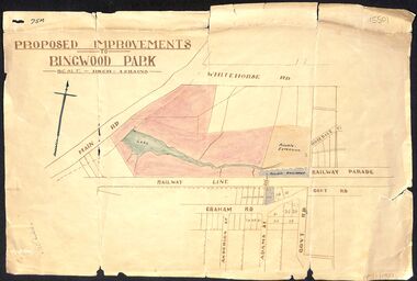 Ringwood and District Historical Society
Map, Proposed Improvements to Ringwood Park (Ringwood Lake) dated 14 January 1927
Proposed Improvements to Ringwood Park (Ringwood Lake) dated 14 January 1927, signed Cr McCaskill. Main Road is Whitehorse Road (Maroondah Highway), and Mt Dandenong Road is incorrectly labelled Whitehorse Road. The map shows Rosedale Crescent and Railway Parade, both of which exist in 2024. On the bottom of the map, south of the railway line, showing proposed streets - Graham Road, Anderson Street and Adams Street - in preparation for the sale of the Theo Anderson property. That area is now Bedford Park. -
City of Kingston
Photograph - Black and white, 5 January 1984
Moorabbin, Cheltenham and Highett are suburbs in the City of Kingston with a diverse mix of development and zoning. The market gardens, farms and paddocks have gradually been sub-divided into housing and industrial estates and associated infrastructure such as schools and shopping facilities. The area includes many parks, reserves and golf courses.This aerial image covers a diverse section of the City of Kingston, taking in the suburbs of Cheltenham, Moorabbin, Beaumaris and Highett. By 1984, the market gardens of the district have been replaced by housing and factories. The Gas and Fuel state-of-the-art Scientific Services Department is visible on Nepean Highway Highett. The CSIRO Highett site can also be seen. Both sites have now been demolished and have undergone remediation. The Southland site is visible and yet to be redeveloped by Westfield. This image portrays the diversity of development in the City of Kingston with a mixture of green spaces, housing and commercial and industrial features.Aerial photograph of Cheltenham, Beaumaris, Moorabbin and Highett within the City of Kingston. The area depicted in the 1984 aerial view includes Eden Street and Edward Street, Cheltenham (top left), Weatherall Road and Reserve Road, Cheltenham/Beaumaris (top right), Turner Road and Chesterville Road, Moorabbin (bottom left), Nepean Highway (left section), Graham Road and Middleton Street, Highett (bottom right). A large section of this image includes Cheltenham Park and Victoria Golf Club.White text: 3831-219 Lens information [indecipherable] RINGWOOD M/S 7922-3 RUN 15 Clockface image 5,300' ASL VIC DLS© 5-1-84cheltenham, highett, industrialisation, urbanisation, moorabbin, beaumaris -
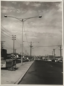
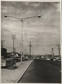
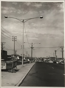
 Ringwood and District Historical Society
Photograph, Whitehorse Road and Mount Dandenong Road, including early electric installation of street lighting. (Undated)
Written on back of photograph, "Whitehorse Road and Mount Dandenong Road". Catalogue card reads, "Early electric installation of street lighting". -
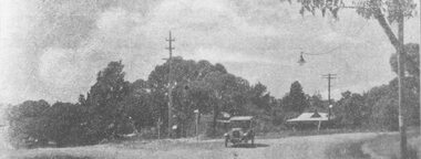
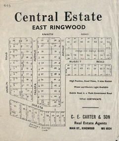 Ringwood and District Historical Society
Flyer, Land Sale Advertisement, Central Estate, East Ringwood - 1948
East Ringwood Central Estate auction sale of allotments previously advertised for Saturday October 23rd (1948). Victorian Collections reference 5138 refers.Single sided leafletSubdivision includes Dublin Road, Knaith Road, Talofa Avenue, Russet Road, and Shasta Avenue. Agent - C.E. Carter & Son, Main Street, Ringwood. WU 6024. -
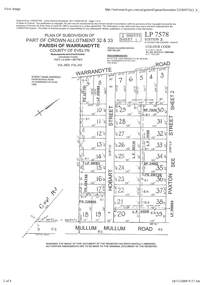 Ringwood and District Historical Society
Document - Subdivision Plan, Part of Crown Allotment 32 & 33 Parish of Warrandyte, County of Evelyn Vol 3922 Fol 242
LANDATA Land Victoria 2-sheet plan printout dated 16/6/2019.Sheet 1 includes Warrandyte Road, Hobart Street, Paxton Street, and Mullum Mullum Road, Ringwood, Vic. Additional markings include PS327701, LP215189, RP7936, LP110103, LP36735, LP31149, SP24012, PS310739, PS326740, PS336885, LP41558. Sheet 2 includes Warrandyte Road, Paxton Street, Arnold Street, and Mullum Mullum Road, Ringwood, Vic. Additional markings include RO270, SP26622, LP50242, RP19467, SP27005, SP31440, PS312181. -
 Whitehorse Historical Society Inc.
Pamphlet, 'Boosting Box Hill'
Pamphlet describing vision for a revitalised Box Hill including plans for Carrington Road, Market Street Mall, Blank facades of Whitehorse Plaza, Prospect street, Whitehorse Road median, tramline extension to Mall Area.box hill carrington road -
 Whitehorse Historical Society Inc.
Photograph, Looking east to Mitcham, c1952
Sent to a parishioner at Christ Church, Mitcham, by Phyllis Grant who lived at the Migrant Hostel in Mitcham in 1952 -54, where her husband did development work under the P.M.G.Black and white photograph of Mitcham looking east from opposite Albert Street. Note the two lane road with trees each side of the road. Christ Church Mitcham in Edward Street can be seen on the left.whitehorse road, mitcham, christ church anglican church mitcham, grant, phyllis -
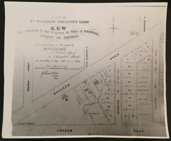 Kew Historical Society Inc
Print - Subdivision Plan, F Price, Plan of Mr William Derrick's Land, Kew being Subdivision of Part of Section 86, Parish of Boroondara, County of Bourke, 1872, 1872 [Original]
This work forms part of the collection assembled by the historian Dorothy Rogers, that was donated to the Kew Historical Society by her son John Rogers in 2015. The manuscripts, photographs, maps, and documents were sourced by her from both family and local collections or produced as references for her print publications. Many were directly used by Rogers in writing ‘Lovely Old Homes of Kew’ (1961) and 'A History of Kew' (1973), or the numerous articles on local history that she produced for suburban newspapers. Most of the photographs in the collection include detailed annotations in her hand.The Rogers Collection provides a comprehensive insight into the working habits of a historian in the 1960s and 1970s. Together it forms the largest privately-donated collection within the archives of the Kew Historical Society.A photographic reproduction of a plan in the Vale Collection of the State Library of Victoria showing William Derricks land in the area bordered by Bulleen Road (High Street); Cotham Road and Union Street. The plan dates from 1872.william derrick, subdivision plans -- kew (vic.)