Showing 987 items
matching roberts william
-
 Flagstaff Hill Maritime Museum and Village
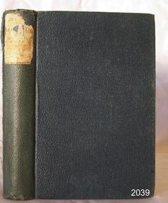
Book - Reference, The Elements of Euclid, 1848
Author John William Colenso (1814-1883) was a mathematician, missionary and renowned clergyman in the Anglican Church. In 1853 he became the first Bishop of Natal, South Africa. The publisher firm, Longmans, Green & Co., was originally founded in 1724 in London by Thomas Longman under the name Longman. In August of that year, he bought the two shops and goods of William Taylor and set up his publishing house there at 39 Paternoster Row. The shops were called Black Swan and Ship, and it is said that the 'ship' sign was the inspiration for Longman's Logo. After many changes of name and management, the firm was incorporated in 1926 as Longmans, Green & Co. Pty Ltd. The firm was acquired by Pearson in 1968 and was known as Pearson Longman or Pearson PLC. The printer, Spottiswoode and Co,, was established in 1738 by William Strahan, with premises in New Street Square, London. The growing firm advertised as Printers, Lithographers, Stationers, Electrotypers, Publishers, and Booksellers and by 1914 there were 1,000 employees. The book is significant for its connection to 19th-century author John William Colenso, was a mathematician and Anglican clergyman who had several works published. The publisher and printer of this book are also significant in their roles for being established in the early 18th century, contributing to the education of the studies of the scholars of the day. The book is also significant for its connection to the publisher Longmans, Green and Co., of London, and printer Spottiswoode & Co., firms that have been established for around two centuries, renowned for publishing and printing reference works that contributed to the education of scholars over many years.The Elements of Euclid by John William Colenso, D.D. (new edition) [The Elements of Euclid (the parts read in the University of Cambridge) from the text of Dr Robert Simson with Geometrical Examples by John William Colenso, D.D., Lord Bishop of Natal} Date: 1846 Publisher: Longmans Green and Co, London Printer: Spottiswoode and Co, New Street Navy blue textured hardcover on the book, with title on a label on the spine.Text on spineflagstaff hill, flagstaff hill maritime museum and village, warrnambool, maritime museum, maritime village, great ocean road, shipwreck coast, longmans green and co., thomas longman, paternoster row london, john william colenso, 19th-century british mathematician, missionary, spottiswoode & co., the elements of euclid -
 Flagstaff Hill Maritime Museum and Village
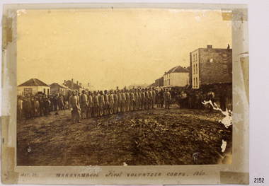
Photograph - Military group, Warrnambool First Volunteer Corps 1860, Taken May 24th, 1860, presented to Mayor in 1887
This Photograph is one of a number of photographs of the Warrnambool Militia. The photograph entitled "Warrnambool First Volunteer Corps" is dated 24th May 1860. (The First Volunteer Corps began in 1855.) It was presented by James Astley Bromfield (former Mayor of Warrnambool) to Major Walter Helpmann, head of Warrnambool’s 1st Volunteer Corps in 1887. The photograph shows the Corps lined up for inspection in Timor Street, Warrnambool. The location is outside what is now the Archie Graham Centre and the camera is looking west towards Liebig Street. The town band is in the right rear corner and spectators surround the Corps. The names listed on the back of the photograph are "1. R.Bushe (Captain in command), 2. Basil Spence, 3. Thomas Mickle, 4. Alfred Davies (Sergeant), 5. Cawthray, 6. Andrew Kerr, 7. Charles Scoborio, 8. Lacy, 9. James Hider, 10. D. O’Mullane, 11. William Norman, 12. Crouthers (or Cowthers ?), 13. Francis Breckon, 14. Russ, 15. Benjamin Wycherley, 16. C. A. Cramer (Sergeant), 17. James Coulstock, 18. Robert Newton (Sergeant), 19. J.A. Bromfield, 20. Singleton (supernumery), 21. Mostyn (Drill Instructor)," On the left of the picture is Billy Adams, Barnes (road contractor) and James Mason (Bootmaker). On the right of the picture is The Band. This is one of a collection of photographs showing the development of the Warrnambool Militia from its inception as the First Volunteer Corps in 1855. The collection is of local significance as it parallels the development of the town and includes images of significant local people. A number of Warrnambool streets are named after members of the Militia. It is also historically significant because of its connection to the unrest that was taking place in Europe at this time. Photograph of Warrnambool First Volunteer Corps 1860, sepia coloured, mounted on cream card. The photograph shows the Corps lined up for inspection in Timor Street Warrnambool. The location is outside what is now the Archie Graham Centre and the camera is looking west towards Liebig Street. The town band is in the right rear corner and spectators surround the Corps. Photograph taken 24th May 1860. Has names listed on reverse side. The protograph was presented to Mayor Helpman, by Bromfield, May 1887. Title printed below base of photo on the mounting board "May. 24. WARRNAMBOOL First VOLUNTEER CORPS. 1860" On the back of the photograph is a numbered list of names, handwritten in ink. Also on the back are presentation details "Presented to Mayor Helpman, by Bromfield, May 1887". warrnambool, wolunteer corps, militia, helpmann, bromfield, flagstaff hill, shipwrecked coast, flagstaff hill maritime museum, maritime museum, shipwreck coast, flagstaff hill maritime village, great ocean road -
 Flagstaff Hill Maritime Museum and Village
Barometer, 1858-1869
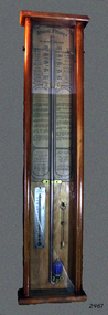
The barometer was either made or sold by T. Gaunt & Co. of Melbourne, a manufacturer, importer and retailer of a wide variety of goods including jewellery, clocks and watches, navigational and measuring instruments, dinnerware, glassware and ornaments. Thomas Gaunt photograph was included in an album of security identity portraits of members of the Victorian Court, Centennial International Exhibition, Melbourne, 1888. (See below for further details.) Admiral Fitzroy Pattern Barometer History: The stick mercury barometer was named after Admiral Robert Fitzroy of the Royal Navy (1805-1865) for his detailed instructions on how to interpret the weather, which were included with the instrument. Fitzroy was the captain of the HMS Beagle, also a weather forecaster to Charles Darwin and the second Governor of New Zealand. He developed many different types of barometers and was the first person to introduce the science of weather forecasting to the British Isles. A local manufacturer of scientific instruments, Thomas Gaunt, produced the barometer that was adapted for the southern hemisphere by Robert Ellery, the State Astronomer based at the Melbourne Observatory. In the original sale catalogue for Gaunt's, the item is described as "Gaunt's Fitzroy Barometers" and it was priced from 25/- to ₤9.9s. History of Thomas Gaunt: Thomas Gaunt established Melbourne's leading watchmaking, optical and jewellery business during the second half of the 19th century. Gaunt arrived in Melbourne in 1852, and by 1858 had established his own business at 14 Little Bourke Street. Around 1869 he moved to new premises in Bourke Street on the corner of Royal Arcade. Gaunt's shop quickly became a Melbourne institution. Gaunt proudly advertised that he was 'The only watch manufacturer in the Australian colonies'. While many watches and clocks may have had Gaunt's name on the dial, few would have been made locally. Gaunt did make some watches for exhibitions, and perhaps a few expensive watches for wealthy individuals. Gaunt's received a telegraph signal from Melbourne Observatory each day to correct his main clock and used this signal to rate and repair ship's chronometers and good quality watches. His main horological manufacturing was directed at turret clocks for town halls, churches and post offices. These tended to be specific commissions requiring individualised design and construction. He made the clock for the Melbourne Post Office lobby, to a design by Government Astronomer Robert Ellery, and won an award at the 1880-81 Melbourne International Exhibition for his turret clock for the Emerald Hill Town Hall. He became well known for his installation of a chronograph at Flemington Racecourse in 1876, which showed the time for the race, accurate to a quarter of a second. The firm also installed the clockwork and figures for Gog and Magog in the Royal Arcade. Thomas Gaunt also developed a department that focused on scientific instrumentation, making thermometers and barometers (from imported glass tubes), telescopes, surveying instruments and microscopes. Another department specialised in electroplating for trophies, awards and silverware, and the firm manufactured large amounts of ecclesiastical gold ware and silverware, for the church including St Patrick's Cathedral. There are no records that disclose the number of employees in the firm, but it was large enough for Gaunt to hold an annual picnic for the watchmakers and apprentices at Mordialloc from 1876; two years previously they had successfully lobbied Gaunt to win the eight hour day. Gaunt's workforce was reportedly very stable, with many workers remaining in the business for 15 to 30 years. Gaunt's wife Jane died on September 1894, aged 64. They had one son and six daughters, but only three daughters survived to adulthood. Two became nuns at the Abbotsford Convent and one daughter, Cecelia Mary Gaunt (died 28 July 1941), married William Stanislaus Spillane on 22 September 1886 and had a large family. Gaunt died at his home in Coburg, Victoria, leaving an estate valued at ₤41,453. The business continued as T. Gaunt & Co. after his death. The barometer is historically significant as an example of the work of Melbourne’s leading scientific instrument maker, Thomas Gaunt. The barometer has social significance as an example of the type of scientific equipment that Thomas Gaunt expanded his horology business into producing. Further social significance lies in the fact that Robert Ellery, the Government Astronomer who designed the local version of the barometer, had a direct connection with the Melbourne Athenaeum founded in 1839 as the Melbourne Mechanics' Institution. Its purpose was "the diffusion of literary, scientific and other useful information". There are also records of a T Gaunt as a subscription and committee member of this the Athenaeum organisation during the 1870s and 1880s which may be Thomas Gaunt, unfortunately still unverified.Stick mercury barometer known as the Admiral Fitzroy Barometer. It comprises an oblong wooden case with glass front panel, ornate pediment, barometer with bulb cistern (empty of fluid), cleaning brush with printed instructions for interpreting information given by the gauge affixed to left and right face of instrument. Includes a thermometer. The barometer appears to be intact. Adapted to the Southern Hemisphere. Special remarks by Admiral Fitzroy. Made by Thomas Gaunt, Melbourne. Manufacturer's details are on back of wooden casing. Rear has upper and lower brass screw plates for securing to vertical surface."Manufactured by Thomas Gaunt, 14 Little Bourke Street, Melbourne. "flagstaff hill, warrnambool, shipwrecked-coast, flagstaff-hill, flagstaff-hill-maritime-museum, maritime-museum, shipwreck-coast, flagstaff-hill-maritime-village, barometer, admiral fitzroy, thomas gaunt, thomas gaunt of melbourne, clockmaker, admiral fitzroy barometer, barometer instructions, gaunt’s fitzroy barometer, gaunt’s of melbourne, gog and magog designer, horological manufacturer, meteorological instrument, melbourne athenaeum, melbourne mechanics' institution, melbourne observatory time signal, robert ellery government astronomer, scientific instrument, stick mercury barometer, thermometer, weather forecast, t gaunt & co -
 Supreme Court of Victoria Library
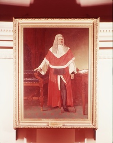
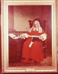
Portrait, Robert Dowling, Sir Redmond Barry, 1886
This painting was created by Robert Dowling (1827-1886) in 1885. At this time Dowling was considered Australia's best portraitist. Dowling had been born in England, but migrated to Van Diemen's Land in the early 1830s with his parents. Dowling worked in both Tasmania and Victoria as an artist, before returning to England in 1857. He did not return to Australia until 1884 and received eighteen commissions for portraits. The Barry portrait was commissioned after Barry's death which explains some of the mistakes in the depiction of Barry's robes; the fur cuffs and collar are too large, and the cummerbund is sitting in the wrong place. Sir Redmond Barry is an important figure in Colonial Victorian History, responsible for the establishment and support of some of our finest cultural institutions (the University of Melbourne, the State Library of Victoria, the Supreme Court Library, and aspects of the Museum of Victoria's collection). This is in addition to his role as barrister defending aborigines in the 1840s and his position as a foundation judge of the Supreme Court of Victoria, a position he held for nearly 30 years, presiding over two of the most well known of colonial trials: the Eureka Trials in 1854 and the Kelly trial in 1880.The portrait of Sir Redmond Barry is significant because of the historical importance of Redmond Barry in colonial Victorian history. The painting is also of aesthetic significance as the work of the distinguished portraitist Robert Dowling. Portrait in oils of Sir Redmond Barry. Barry is depicted standing, dressed in red Judicial robes, his hand resting on a chair; behind is a table with books.Signed and dated 1886 (lower left) by Robert Dowling.redmond barry, portraits, judges, robert dowling -
 Supreme Court of Victoria Library
Portrait, Sir Robert Molesworth
The portrait was commissioned in 1884, near the end of Molesworth's term of office. The portrait was commissioned at the same time as those of Redmond Barry and Chief Justice Stawell. Robert Molesworth, like his contemporaries, Stawell and Barry, went to Trinity College, Dublin, and practiced at the Irish Bar before migrating to Australia in 1852. Molesworth quickly gained a large practice at the Bar. In 1853 he was acting Chief Justice and he later served as Solicitor-General in the early Victorian colonial administrations. Molesworth was appointed to the bench in 1856. He primarily worked in the Equity area, but his main contribution to Colonial administration was as the Chief Judge of the Court of Mines, establishing the basis of mining law in Australia.The portrait of Molesworth is significant because of whom it portrays and is the only known portrait of Molesworth.Full length portrait in oils of Sir Robert Molesworth. He is seated at a desk and dressed in Judicial robes. The frame is of 20th century originSigned with monogram and dated 1885 lower left. Plaque identifies sitter as The Hon. Sir Robert Molesworth Judge of the Supreme Court. 1856-1886courts, molesworth robert, a beckett edward -
 Orbost & District Historical Society
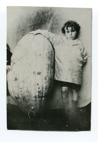
black and white photograph, Warren. Mrs H, late 19th century - early 20th century
This photograph is of Percy Nixon, son of James Nixon and Alice Roberts Percy Nixon married Evelyn Harding. The photographer was Warren, Helena (1871-1962) who was a self-taught photographer who became both the local press correspondent and a producer of humorous trompe l'oeil postcard images. Helena Warren was a thirty-two year old settler living on a small mixed farm with her husband, William, at Newmerella, near Orbost in Gippsland, Victoria, when she bought her first camera, an Austral Box quarter-plate. Her family says she was entirely self-taught, like many women photographers who started out with nothing but the instructions on the packets of film and chemicals. In over fifty years practice she graduated from the total novice, who opened all her first mail order plates in bright sunlight and ruined them, to a competent photographer who became both the local press correspondent and an inveterate producer of humorous trompe l’oeil postcard images. Helena Francis Warren (nee McKeown) was married to William John Warren and lived in Newmerella. She supplied the photos for the Back-To-Orbost celebration book in 1937 and also designed the Back-To-Orbost badge. She was known for her soft toy making. (by Ivy Rodwell in from Personalities and Stories of the Early Orbost District by Mary Gilbert). This item is associated with a prominent Orbost family. George Nixon was the son of James and Alice Nixon. The Nixon families were among the earliest settlers on the Snowy River. This photograph also has significance in its association with Helen Frances Warren, a popular Orbost identity who was well known as an accomplished photographer and needleworker.A black / white photograph of a young boy standing next to a very large pumpkin. His right arm is resting on the top.pumpkins-orbost warren-helena-photography nixon-percy -
 Bendigo Military Museum
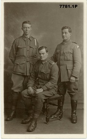
Postcard - POSTCARDS, PHOTOGRAPHIC WW1, Edgar Dawson collection : Battalion comrades
This six-postcard group is the second in a series of records of items in the collection of Edgar Dawson DCM. Dawson was the Regimental Sergeant Major of 57th Battalion, AIF. The 57th had a company of men largely from Bendigo and Eaglehawk. These postcards are from his personal album. Many are annotated in Dawson's hand with explanatory notes on the subject. Refer to Cat No 893 for his service details. Items originally in album cat. no. 207P Service details available through the NAA. Collection of six black and white postcards: 1. Photographic portrait from left William George Saville 4182, Alexander Pollock 3587 57th Btn, and unidentified trooper, possible 4th Light Horse Regiment. 2. Photographic portrait of Light Horse trooper. 3. Photographic portrait of William Tamlyn Curnow, 5078, 57th Btn 4. Photographic portrait of "Jim", 5. Photographic portrait of Septimus Fletcher, 4485, 57th Btn 6. Photographic portrait of Robert Gamble, 4644, 57th Btn 2. Card is addressed to "1904 L.Cpl W.W. Martin, D Cpy 57th Batt". Martin was 2150, KIA 26th September 1917. 3. On front "Sincerely, W. T. Curnow". On verso, "To Hec, from his old pal Curnow Sgt" 'Hec' was Dawson's nickname. 4. On front "Yours sincerely Jim". On verso, card addressed "350 Pte Melen, R. C., 15th Field Ambulance, via Manners St Maryborough Victoria" The 15th Field Ambulance Cpy, supported the 57th and other battalions of the 15th Brigade. 5. On verso "This is an Eaglehawk boy Septimus Fletcher, he came over with me and was with us a long time, but is on Division now" 6. On verso "This is our signal Cpl wearing his military medal for keeping communication at Bullecourt". Gamble won the MM for his actions 13th May 1917.57th battalion, postcards, album dawson dcm, edgar dawson dcm -
 Bendigo Military Museum
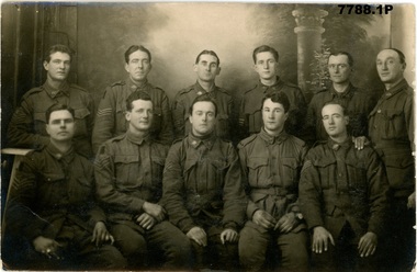
Postcard - POSTCARD PHOTOS WW1, Edgar Dawson Collection : Sergeants of the 57th Battalion group photos, 1918
This four-postcard group is the ninth in a series of records of items in the collection of Edgar Dawson DCM. Dawson was the Regimental Sergeant Major of 57th Battalion, AIF. C Company of the 57th was composed of men drawn from Echuca, Eaglehawk and Bendigo. The postcards are from his personal album, and many are annotated in Dawson's hand with explanatory notes on the subject. Refer to Cat No 893 for his service details. Items originally in album cat. no. 207P 1. From left, lower: Ross, Angus John William 4584 Wilkinson, Albert James 4627 Wheaton, Stanley 4631 Shearer, Robert John Lesley 2896 Macken, Charles Anthony 2007 Howard, Ray Septimus 3556 Rogers, Ernest 1764 Harris, Alfred George 1959 Cockram, Louis 955 Short, Stanley 2684 Rex King (number not traced) 2. Unidentified group of sergeants, 57th Battalion 3. A Company sergeants, 57th Battalion 4. B company sergeants, 57th Battalion 1. Names on verso 2. "Yours sincerely, J.W. Brown Sgt, 57th Battalion, A.I.F pt address Etonia, Coorigil Road Murrumbeena Victoria" 3. "These are the sergeants of A company of our battalion" 4. "This is B company sergeants of our battalion. The three in front came over on the boat with me" postcards, 57th battalion, edgar dawson dcm -
 Bendigo Military Museum
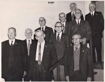
Photograph - RSL 50 YEAR MEMBERS, C. 1972
All the men in the photo were Great War soldiers. On the day of the presentation in 1972 the men were accompanied by their wives or relatives and treated to afternoon tea by the RSL Ladies Auxiliary and entertained by two RSL members George Elliot and George English. Top. Norman McLaren Young Regt No 7595, 13th & 14th Bn's. Thomas Richardson Liddle Regt No 1963, 21st Bn. Centre. Wm Earl Waters Regt No 718, 22nd Bn & 4th Fld Engineers. Robert Harrowfield Regt No 4954, 8th Bn. Jabez Hopkins Merryman Regt No 1981, 11th Bn & 1st M.G Bn. Bot. William Flett Regt No1767, 22nd & 24th Bn's. George Keir Regt No 1374, 13th LH Regt. David Jones Regt No 2670, 57th Bn. Norman Charles Boyle Regt No 1803, 38th Bn. Roy McEwan Johnson Regt No 2671, 57th Bn.Photograph B & W showing a group of 10 men who recieved their 50 year membership Certificates as members of the Bendigo RSL Sub Branch. Photograph was taken on the stairs to the stage in the Main Hall of the Soldiers Memorial Institute Bendigobrsl, smirsl, 50 years, membership, wabrsl -
 Bendigo Military Museum
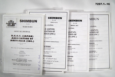
Booklet - BOOKLETS, BCOF, B.C.O.F. (Japan) ASSOCIATION OF AUSTRALIA (INC)
Booklets are the - "OFFICIAL JOURNAL/ B.C.O.F. (JAPAN)/ ASSOCIATION OF/ AUSTRALIA (INC)/ Since 1972/ (Navy, Army, Air Force, Women's & Auxilliary Forces)" Please note - name change from "SHIBUM to SHIMBUN' on these booklets. Shinbun and Shimbun - is the correct spelling for the word for newspaper in Japanese. Booklets - items in the collection of Richard William McGILVERY, RAAF. Refer Cat No. 7287P for his service details, photos, awards.SOFT COVER BOOKLET. ALL BOOKLETS - PAPER WITH BLACK PRINT ON FRONT AND BACK. CHRISTMAS ISSUES HAVE DECORATIVE TRIM IN GREEN AND/OR RED PRINT. ILLUSTRATED WITH " BRITISH COMMONWEALTH FORCES" WITH CROWN ON FRONT COVER. All booklets 20 to 36 pages, cut, plain, white paper. Illustrated with black and white photographs, maps and cartoons. 1. No. 140 March 2011. 2. No. 141 June 2011. 3. No. 142 September 2011. 4. No. 143 December 2011. 5. No. 144 March 2012. 6. No. 145 June 2012. 7. No. 146 September 2012. 8. No. 147 December 2012. 9. No. 148 March 2013. 10. No. 149 June 2013. 11 No. 150 September 2013. 12. No. 151 December 2013. 13. No. March 2014. 14. No. 153 June 2014. 15. No. 154. September 2014. 16. No. 155 December 2014. 17. No. 156 March 2015. 18. No. 157 June 2015. 19. No. 158 September 2015. 20. No. 159 March 2016. 21. No. 160 September 2016. 22. No. 161 March 2017. 23. No. 161 March 2017. 24. No. 162 September 2017. 25. No. 163 March 2018. 26. No. 164 September 2018. Front cover, handwritten notes, blue or black ink. 1. 2. 3. 4. 8. 13. 1. "All of this book". 2. "Pages 3,5,7,8,9,13,16,17,19 to 24." 3. "Pages 3,4,12,13, to 23." 4. On paper "Pages 3-8, 10, 16, 19 to 24" 8. "26 mags altogether/ the 2 you have already read" 13. "Jane/Danny/ 9915/ 48/ 04". 19. " Lorraine 0353920942=/Willa McGilvery, PO Box 132/Donald/ 3480/ 03 5497 1724". 20. "My letter to sacked MP Stuart Robert". 21. "Please return Willa". 22. "Buloke Times write up". history, booklets, bcof -
 Bendigo Military Museum
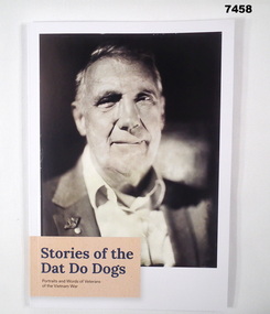
Book - BOOK, VIETNAM, Jock McLAIN in Collaboration with the Anzac Memorial. Commonwealth Department of Veteran Affairs, "Stories of the Dat Do Dogs", 2023
From cover of book; "Stories of the/ Dat Do Dogs/ Portraits and Words of Veterans/ of the Vietnam War.Soft cover book. Cover - cardboard, with dark blue and black print. Illustrated in black and white, front and back, a portrait of Vietnam War Veterans. "Front cover - Ordinary Seaman (Electrical Mechanic) Gary William Oakley". "Back cover - Private Robert Charles Pearson". 60 pages, cut, plain, white paper. Illustrated black and white and sepia portrait photographs. Map of Vietnam in colour."books, biographies, vietnam -
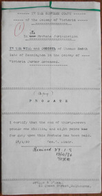
 Warrnambool and District Historical Society Inc.
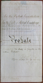
Document - Robert Cuppage Probate 1904, 1904
Tait collection: item 24 of 62 This is a 1904 document giving information on the Will and Probate of Robert Cuppage. He was a labourer who lived at Woodford and he and his wife, Jane received much sympathy following the deaths from diphtheria of five of their children in 1866. Charlotte (3) and Elizabeth (14) died on 26th August, Robert (6) died on 27th August, Hanne (8) died on 30th August and George (15) died on 14th September. Jane Cuppage died in 1889 and Robert died in December 1903. He left real estate to the value of £240 and personal estate to the value of £5 to his daughter, Margaret Trigg. Ernest Chambers had legal offices in Warrnambool, Port Fairy and Koroit at the end of the 19th century and the beginning of the 20th century. This document was in his possession and it was passed down to successive lawyers occupying the legal offices in Kepler Street and located in this building in 2014 and passed on the Warrnambool and District Historical Society. This is an interesting document as it gives the Will and Probate details of a well-known Woodford resident in the 19th century. It will be useful to researchersThis is a piece of cream-coloured parchment paper folded in two and containing handwritten material on four sides of the paper. It contains details on the Will and Probate of William Charlesworth, 1904. The seal of the Supreme Court of Victoria is attached with green ribbon and there are two purple stamps, one from the Master in Equity of the Supreme Court in Melbourne and the other from the Bank of Australasia in Warrnambool. The document is somewhat stained on one side but the writing is legible.In the Supreme Court of Victoria; In the Probate Jurisdiction; In the Will of Robert Cuppage late of Bushfield near Warrnambool in the State of Victoria Labourer deceasedrobert cuppage, ernest chambers, warrnambool, bushfield, tait collection -
 Warrnambool and District Historical Society Inc.
Document, Thomas Smith Probate 1880
Tait collection: item 33 of 62 This probate document gives details of the will of Thomas Smith, a farmer in the Wangoom district who was a pioneer settler, having arrived in the area about 1848. He erected the Shamrock Hotel in Dennington in 1868 and it was opened for business in 1869 with David Duffy as the first licensee. Thomas Smith was the licensee in 1870 and members of his family (Cornelius, Robert and Mary Smith) held the licence of the hotel until 1880. A codicil to the will gave Mary Smith, Thomas’ daughter, the hotel land and building. This hotel closed in 2011. Thomas Smith signed the original will with a cross (his mark). Other names mentioned in the probate document are Frederick Wilkinson, Master-in-Equity, Ernest Chambers, Solicitor, John Drayton, Clerk to E. Chambers, William Ardlie, Senior, Solicitor, Thomas Goodall, Clerk to William Ardlie, Richard Sheldrick, Clerk to William Ardlie, Walter Davies, Stationer.This is a significant document as Thomas Smith was a prominent owner of land, especially in the Dennington area. The Shamrock Hotel in Dennington was built by Smith and still owned by him when he died in 1880. The will gives important details of the estate of Thomas Smith and adds to our knowledge of his life and work. Document – Probate, 1880/1907 - the Will and Codicil of Thomas Smith, Farmer of Dennington The will has six ruled paper pages of typewritten material. Each page has printed ruled red lines top, bottom and sides and all are tied with green corded string. There are handwritten corrections and signatures, including those of Ernest Chambers, Solicitor of Warrnambool and John Drayton, Clerk to E. Chambers.Thomas Smith Shamrock Hotel, Dennington Ernest Chambers, Solicitor thomas smith wangoom 1848, shamrock hotel dennington, warrnambool history, thomas smith 1880 -
 Warrnambool and District Historical Society Inc.
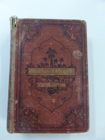
Book, Martin Tattler, 1876
This book, by the well-known author R.M.Ballantyne, was awarded to Edith Newton in 1877 when she was a pupil at the Warrnambool State School. This school was opened on August 1st 1876 when the National School in Warrnambool closed and most of the pupils of other denominational schools in Warrnambool at the time moved to the new State School. The Head Teacher, William Bryant was at the school until 1894. (Blanch) Edith Newton was born in 1868, the eighth child of Robert and Mary Newton. Robert Newton was a Rate Collector, Borough Inspector and Manager of the Town Common in Warrnambool. It is noted that the prize received by Edith Newton was an adventure book mostly appealing to male readers. This book is significant because it is connected with important elements in Warrnambool in 1877 – the school, Warrnambool State School, the pupil, Edith Newton and the Head Teacher, William Bryant,This is a hard cover book of 330 pages. It has a dark red cover with etched ornamental borders and patterns and an image of a jungle scene on the front cover and on the spine. The title and author’s name are in gold lettering. At the heading of each chapter there is an ornamental scroll and there are several black and white sketches throughout the pages. There are blue stamps of the Warrnambool & District Historical Society at the front and back of the book and a school plate label attached to the inside front cover. The spine is partly detached and torn and the cover is very worn and water or mould damaged. A letter from the donor accompanies the book. ‘Warrnambool State School, No. 1743, Prize Awarded to Edith Newton, 4th Class, Divn. 111, for Home Exercises, 19th December 1877, W.Bryant, Head Teacher.’ warrnambool state school, history of warrnambool, william bryant, edith newton -
 Warrnambool and District Historical Society Inc.
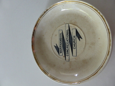
Plate, Warrnambool Congregational Church, Early 20th century
This plate comes from the Congregational Church in Warrnambool. It was probably part of a set of crockery used by church members at social events. The Warrnambool Congregational Church was established in 1862 when Robert Winton and Thomas Nayler set up a meeting to discuss the possibility of establishing an Independent Church in Warrnambool. The first minister was William Pentland and the first church was opened in 1864 in Liebig Street. Samuel Nettleton was a notable early church member, being Superintendent of the Sunday School for 60 years. A new church was opened in Henna Street in 1940. In 1973 the Congregational Church merged with the Methodist Church to form the Uniting Church in 1977. In 1976 the former Congregational Church in Henna Street was sold to the Salvation Army. This plate is of interest as a memento of the former Congregational Church in Warrnambool. In the early to mid 20th century this church was a strong and influential force in the Warrnambool community. This is a cream-coloured dinner plate made of china. The gold bands around the edge of the plate are now almost obliterated. The lettering in the middle of the plate is black and white. The plate has several chips on the edge and is somewhat stainedWarrnambool Congregational Church’warrnambool congregational church -
 Warrnambool and District Historical Society Inc.
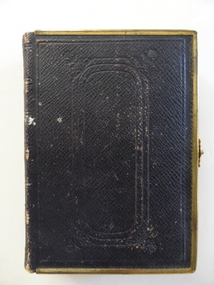
Book, Bible (in Welsh), 1868
This Welsh Bible belonged to Ellen Hughes who was Welsh-speaking and the daughter of a farmer from Caernarfonshire, Wales. In 1874 she married William Jones of Warrnambool and became a stepmother to Robert Jones who was to become the owner of the property The Union, near Woolsthorpe. Robert’s daughters, Gwen and Edna Jones, gave this Bible to the Warrnambool and District Historical Society. They were both members of the Society. This book is of great importance as a beautiful memento of the 19th century when the Welsh Calvinistic tradition was strong in the Warrnambool district and a Gaelic church was operating in Woodford and services in Gaelic services were held regularly in Warrnambool. This is a hard cover book with a brown leather cover with gold metal edging and a gold clasp. The cover has embossed patterns on the front back and spine. The pages have gilt edges. The text is in the Welsh language and is presented in two columns per page. There is one blue stamp of the Warrnambool and District Historical Society on the first page. The inscription is handwritten in black ink. ‘Presented to Miss Ellen Hughes by her wellwishers Hugh and Kate Pritchard, Llanfairfechan, July 14th 1871’ ellen hughes, gaelic church, woodford, history of warrnambool, the union -
 Warrnambool and District Historical Society Inc.
Document, Lease agreement 1862 William Melville & Augustus and James Bostock, 1862
Augustus Bostock was the 9th child of Robert & Rachael Bostock of Vaucluse Epping Forest, Van Diemen’s Land. He was only 4 years old when his mother died. He along with his brothers, was inspired by his father to seek his fortune in the Western District of Victoria. He arrived around 1850. He married Margaret Aitkin in July 1865. Augustus owned several properties in the district and leased others. He sat on the court of Warrnambool, Mortlake or Hexham as required. He resided at Marramook in Hawkesdale and later moved to Vaucluse in Hopetoun Road Warrnambool, where he died in 1920 at the age of 87. He was involved in many aspects of life in the Western District, racing, cricket, and social activities to name a few. James Bostock was the youngest of Robert and Rachel Bostock with his mother dying in childbirth with his delivery. He loved working with horses and was close to his brothers Augustus and John. He was the third of the Bostock brothers to marry an Aitkin sister in this case Alice in 1875. He was a commission agent and money lender in Warrnambool. He died in 1919. In the 1860/70’s William Melville traded in partnership with William Bayles as merchants in Melbourne and as landholders and leases of land in the Western District Weerangourt with 14192 acres freehold. This lease is for approximately 6000 acres and is for a period of 10 years at 2/9 per acre. This is one of a number of documents which relate to the Bostock family who were one of the most important pioneering families of the Western District. They owned and leased various properties around Warrnambool and were involved in many aspects of social and business life. The document itself is indicative of its time and provides an insight into the details and terms of such documents at the time. Ten page, large sheeted document, handwritten in black ink on blue paper. It has been folded in four. Date and names of people involved on one section.William Melville Augustus Bostock James Bostock.warrnambool, bostock, augustus bostock, james bostock, william melville, lease 1862, -
 Warrnambool and District Historical Society Inc.
Document, Indenture A Bostock Esquire to Messrs Aitkin & Bostock( Ernest), 1865
... warrnambool, bostock,augustus bostock james william... william manifold aitkin,robert brand paterson, coomete, Signed ...The Bostock, Manifold and Aitkin families were all pioneering families in the Western District of Victoria almost from the time of settlement. They leased and owned vast tracts of land and operated businesses around the district, often associated with the farming industry. This document is dated 5th July 1865 and is an assignment of stock by way of mortgage. Augustus Bostock is the mortgagor with James William Manifold Aitkin and Ernest Bostock as mortgagees. At various times they were involved in running businesses together, in particular the Aitkin and Bostock store and flour mill. Three of the Bostock men were married to three of the Aitkin sisters. The amount in question is £2157/3/2 and surety is 8000 sheep and their increase, presently running at Coomete. The penciled in details on the document refer to Robert Brand Paterson who was later in business with Aitkin This is one of a number of documents which relate to the Bostock family who were one of the most important pioneering families of the Western District. They owned and leased various properties around Warrnambool and were involved in many aspects of social and business life. The document itself is indicative of its time and provides an insight into the details and terms of such documents at the time.Large grey coloured, lined hand written document over four pages. Folded in four with date and details on one section. Red wax seal on page 3. There are extra entries written in black lead pencil in areas relating to the money and surety of the agreement.Signed by the following George Barber Warrnambool, Thomas Sunderland Deputy Registrar General, and Augustus Bostock. Hingston & Co, Chancery Lane Melbourne hand written in top left hand corner. warrnambool, bostock,augustus bostock james william manifold aitkin,robert brand paterson, coomete, -
 Warrnambool and District Historical Society Inc.
Plate, Saucer, Early 20th century
This saucer came from the Warrnambool Congregational Church and was probably part of a set of crockery used by the church members at social gatherings. The Warrnambool Congregational Church was founded in 1862 when Robert Winton and Thomas Nayler conducted a meeting in Warrnambool to consider the possibility of forming a local Independent church. The first minister was William Pentland and the first church was in Liebig Street. A notable member of the Congregational Church was Samuel Nettleton who was the Superintendent of the Sunday School for 60 years. In 1940 a new church was opened in Henna Street. In 1973 there was a merger of the Congregational Church and the Methodist Church, resulting in the formation of the Uniting Church in 1977. In 1976 the former Congregational Church in Henna Street was sold to the Salvation Army. This saucer is of interest as a memento of the former Congregational Church in Warrnambool. It comes from the early 20th century days when the church would have had a strong following in the city. This is a cream-coloured saucer with double gold edging around the outer rim. The lettering in the middle of the saucer is black and white. The inside of the saucer is much stained. ‘Warrnambool Congregational Church’warrnambool congregational church, history of warrnambool -
 Warrnambool and District Historical Society Inc.
Program, Clara Butt, 1913
This is a programme for a 1913 Clara Butt and Kennerley Rumford concert in the Warrnambool Town Hall. Clara Butt (1872-1936) was an English contralto recitalist and concert performer, well-known for her powerful and deep voice. Her three months’ tuition in Paris was sponsored by Queen Victoria. She was married to Kennerley Rumford in 1900 and they had three children. Robert Henry Kennerley Rumford (1870-1957) was an English baritone singer known initially for his performance of oratorio. Clara Butt and Kennerley Rumford were called ‘the greatest classical Valentines’. Other performers listed in this concert programme were Mowat Carter, a Melbourne-born violinist and William Murdoch, a pianist, composer and author, born in Bendigo.This programme is of considerable significance as it records the visit to Warrnambool of the famous English singer, Clara Butt. It is an original programme and it is probably a rare one. This is an eight-page programme, consisting of two sheets of cream paper folded in half. The programme was stapled but the staples have been removed. The front cover has blue printing and the back cover has an advertisement in blue print. The print on the inside pages is in black. Two inscriptions are handwritten in blue ink.‘1913’ ‘N.J.Absalom’clara butt, kennerley rumford, warrnambool town hall, history of warrnambool -
 Warrnambool and District Historical Society Inc.
Plate, Warrnambool Congregational Church, Early to mid 20th century
This plate was probably part of a crockery set used by the Warrnambool Congregational Church for church functions and receptions. The Warrnambool Congregational Church began when two men, Robert Winton and Thomas Nayler, met in 1862 to discuss the possibility of establishing a church of the Independent order. As a result the first Congregational Church was opened in Liebig Street, Warrnambool in 1864 with William Pentland as the first Minister. Samuel Nettleton was a notable member of the congregation, being the Superintendent of the Sunday School for 60 years. In 1940 the Congregational Church moved to a building in Henna Street and in 1973 the Congregational Church merged with the Methodist Church to form what is known today as the Uniting Church. In 1976 the former Congregational Church building in Henna Street was sold to the Salvation Army. This plate is of interest as a memento of the Warrnambool Congregational Church, an institution that no longer exists under that name. This is a cream-coloured china plate with a gold trim around the outer edges and the name of the church in the centre in a black and white scroll pattern. The gold trim is now almost obliterated. The edges of the plate are chipped in several places and the plate is much stained and blotched. ‘Warrnambool Congregational Church’ congregational church, warrnambool, history of warrnambool -
 Warrnambool and District Historical Society Inc.
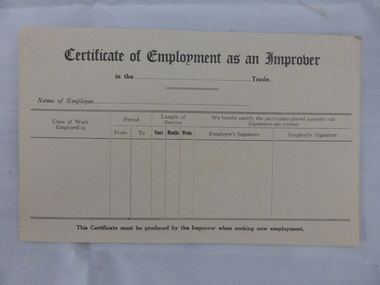
Document, Swintons certificate of Employment as an Improver, Mid 20th C
This certificate would have been used in the Warrnambool business of Swintons Pty Ltd. in the 20th century. It is a certificate that, when filled in, would have been given to anyone who had worked for some time as an unapprenticed tradesman’s assistant. William and Ann Swinton migrated to Australia in 1854 and for a decade William Swinton worked as a builder and carpenter in the Warrnambool district, erecting many buildings, including the Wangoom Presbyterian Church. In 1865 he opened a store in Timor Street, Warrnambool, selling groceries, china, glassware and hardware. By 1888 the business was known as William Swinton and Sons. Branch stores were opened in Wangoom, Cudgee, Nullawarre, South Warrnambool and West Warrnambool. After William Swinton’s death his son Robert became the first managing director of Swintons Pty Ltd. In 1934 the business split, with George Swinton and Sons selling clothing, furnishings and glassware and Swintons Pty Ltd selling hardware, seeds and produce. Today the Swinton family still operates a furniture and bedding store in Timor Street. This certificate is of minor interest as an example of a form used by businesses such as Swintons Pty Ltd to give to employees leaving the business. The current Swinton business in Timor Street, Warrnambool is the oldest family business in Warrnambool and, with the name Swinton associated with Timor Street businesses for 152 years, it is amongst the oldest family businesses in Australia.This is a sheet of buff-coloured paper with printed black lines and printed headings. The sheet is unused and slightly bent. ‘Certificate of Employment as an Improver’ swinton, history of warrnambool, warrnambool -
 Warrnambool and District Historical Society Inc.
Documents, Swintons Paper att 18/53 Merri St. Contract. Map. Notes, 1959
These documents relate to the sale of land in Merri Street Warrnambool in 1959 by Swintons Pty Ltd of Warrnambool. The buyer of the land was George O’Grady, a Warrnambool baker. The land sold for £4000 and there was a shed on the land (called the ‘Office’) which George O’Grady indicated he wished to be included in the sale. William and Ann Swinton migrated to Australia in 1854 and for a decade William Swinton worked as a builder and carpenter in the Warrnambool area, erecting many buildings, including the Wangoom Presbyterian Church. In 1865 he opened a store in Timor Street Warrnambool, selling groceries, hardware, china and glassware. By 1888 the business was known as William Swinton and Sons. Branch stores were opened in Wangoom, Cudgee, Nullawarre, South Warrnambool and West Warrnambool. After William Swinton died his son Robert became the first managing director of Swintons Pty Ltd. In 1934 the business split with George Swinton and Sons selling clothing, furnishings and glassware and Swintons Pty Ltd selling seeds, produce and hardware. Today the Swinton family still operates a furniture and bedding shop in Timor St Warrnambool.These items are of some interest as being connected to the Warrnambool business of Swintons Pty Ltd. They will be of interest to researchers. The current Swinton business in Timor Street is the oldest family business in Warrnambool and, with the name Swinton associated with businesses in Timor Street Warrnambool for 152 years it is amongst the oldest family businesses in Australia.The items here relate to the sale of land by Swintons Pty Ltd., Warrnambool. .1 These are three pages of white paper with typed material, a lawyer’s signature in blue ink, one green stamp and a sketch of the land location. .2 This is a sheet of thick paper containing a plan of the land sold. The paper has printed material and a sketch of the land with part of it coloured in pink. .3 This is a small piece of paper torn at the bottom right edge. It has handwritten material (a letter) in blue ink..2 ‘Plan of Survey of Part of Crown Allotment 18 Section 3 Township of .2 ‘Plan of Survey of Part of Crown Allotment 18 Section 3 Township of Warrnambool Parish of Wangoom County of Villiers’ .3 ‘Tuesday Dear Mr Swinton I am writing to say that I would like to have the ‘Office’ Thanking You George O’Grady’swinton family,, warrnambool -
 Warrnambool and District Historical Society Inc.
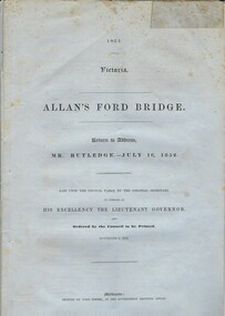
Document, Allan’s Ford Bridge 1852, 1852
This is an original Victorian Government document containing the printed version of 37 reports and letters regarding the building of the first Allansford bridge completed early in 1852. The correspondence dates from October 1850 to February 1852 and includes letters and reports from Melbourne Government employees such as Robert Hoddle, Chief Surveyor, David Lennox, Superintendent of Bridges and Lieutenant – Governor Charles La Trobe. The correspondence from local settlers included the names of William and John Allan, John Davidson and James Coulstock. The correspondence shows that some settlers in the Warrnambool/Port Fairy district wanted a portion of the Government allocated funds spent on the local roads and bridges in other locations. The 1852 Allansford bridge cost £480 and was replaced in 1870. This document has strong historical significance as it relates to one of the earliest State government works in the district and records the public imput into the decision.. It contains opinions and correspondence between a number of early settlers in the district at the time.Grey/blue paper document with black text. 21 pages plus 4 page index at back.allan's ford 1852, allansford bridge, allansford, history of allansford, warrnambool -
 Warrnambool and District Historical Society Inc.
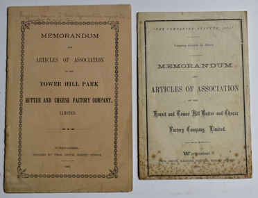
Booklet - Memorandum and Articles of Association 003048.1 Tower Hill Park Butter and Cheese Factory Company Ltd; 003048.2 Koroit and Tower Hill Butter and Cheese Factory Company Ltd, Thomas Smith Printer, 003048.1 1893; 003048.2 1888
... gleeson john quirk michael hally robert kerr william crowe james ...These booklets document the formation and the aims of two early dairy factories in the Koroit and Tower Hill area. These factories later became part of the Koroit FactoryThese two memorandums of association document the formation of two early butter and cheese factories in the Koroit and Tower Hill area, listing the first directors. A meeting at the Koroit Town Hall on May 23, 1888, unanimously decided to form the Koroit and Tower Hill Butter Factory coy. Ltd. Mr W J Anderson started the movement to establish a butter factory to suit the convenience of the share farmers of the Tower Hill Park estate in the early 1890's. Both of these factories were ultimately bought out by the Koroit Factory.003048.1 10 page small buff coloured booklet dated 1893 with pencilled note "Supplier names to Dept. Agriculture requesting Pamphlets be sent them" 003048.2 8 page cream coloured booklet dated 1888003048.1 Memorandum and Articles of Association of the Tower Hill Park Butter and Cheese Factory company, Limited. Warrnambool Printed by Thos. Smith, Koroit Street. 1893 003048.2 "The Companies' Statute, 1864" company limited by Shares Memorandum and Articles of Association of the Koroit and Tower Hill Butter and Cheese Factory, Limited. ~ Warrnambool: Thos. Smith, Machine Printer, Koroit Street, 1888memorandum and articles of association, butter and cheese factory, tower hill park butter and cheese factory, koroit and tower hill butter and cheese factory, thomas smith printer, dairying factory, john wilson anderson, john campbell jnr., joseph lamb wall, thomas gleeson, john quirk, michael hally, robert kerr, william crowe, james young, patrick mcgrath, richard skilbeck, peter mcvicar, tower hill park, illowa -
 Warrnambool and District Historical Society Inc.
Album - Bonnett Family Scrapbook
White two ring bantex folder of 37 plastic sleeves containing white A4 pages with newspaper cuttings. There are some handwritten pages at the rear.Early 20thC. newspaper cuttings. (kept by Bonnett family - Mepunga East)bonnett family, mepunga east, scrapbook, gall, chambers, morgan, moloney, jenkins, mclean, rev samuel fraser, spence, adams, bennett, robisson, sheedy, patrick maher, w j freckleton, j j buckley, john steel, f j hennessy, thomas gordon scott, william r jackway, c c williams, c w cooke, henry w frich, leo p gartlan, w f heazlewood, william k o'dowd, ralph j levings, w ewart murnane, t d donovan, j w connolly, arthur butler, george white, jim g davidson, a roberts, jack keith, w. allwood, voutier, edward somerville, harold wright, w a egan, p macnamara, carl d fisher, p morgan, david watson, cecil h fox, james tinker, gordon patterson -
 Warrnambool and District Historical Society Inc.
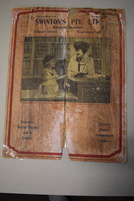
Advertising, Swintons Pty Ltd, Late 1920s
This advertising card comes from the Warrnambool business of Swintons Pty Ltd. William and Ann Swinton migrated to Australia in 1854 and for a decade William Swinton worked as a builder and carpenter in the Warrnambool area. In 1865 he opened a store in Timor Street, Warrnambool, selling groceries, hardware, glassware and china. By 1888 the business was known as William Swinton and Sons. Branch stores were opened in Cudgee, Nullawarre, Wangoom, West Warrnambool and South Warrnambool. After William Swinton died in 1901 his son Robert became the first managing director of Swintons Pty Ltd. In 1934 the business split with George Swinton and Sons selling furnishings, clothing and glassware and Swintons Pty Ltd selling seeds, produce and hardware. Today the Swinton family still operates a furniture and bedding store in Timor Street. This card is of interest as it is a memento of the Warrnambool business of Swinton Pty Ltd. The current Swinton business in Timor Street is the oldest family business in Warrnambool and with the name Swinton associated with Timor Street businesses for over 150 years, it is amongst the oldest family businesses in Australia. This is a piece of cardboard torn in half but joined together with adhesive tape. The cardboard originally had a pink or white background but it is now very stained. The card has a red border with ornamental corners and a black and white photograph of a woman using a telephone and a young girl. The card also has dark blue printing. The card has had printing on the back but this is now covered over with a paper backing. ‘Phone 36 With Compliments from Swinton’s Pty Ltd Universal Providers Timor Street Warrnambool’ ‘Branches: Raglan Parade and at Cudgee’ ‘Grocery Drapery Ironmongery Crockery’ swintons pty ltd, warrnambool, history of warrnambool -
 Warrnambool and District Historical Society Inc.
Book, Swintons Stock book 1869, 1860s
... Warrnambool. When William died his son Robert became the first... William died his son Robert became the first managing director ...This ledger is a Warrnambool Swintons Store stock book and contains the sales of stock from September 1869 to an unknown date (perhaps to the end of 1870) and entries for 1871, 1872 and 1873, 1889, the 1890s and some dates early in the 20th century. William and Ann Swinton migrated to Australia in 1854 and for a decade William Swinton worked as a builder and carpenter in the Warrnambool area, erecting many buildings, including the Wangoom Presbyterian Church. In 1865 he opened a store in Timor Street, Warrnambool selling groceries, glassware and china. In 1888 the business was known as William Swinton and Sons. Branch shops were opened in Cudgee, Nullawarre, Wangoom, South Warrnambool and West Warrnambool. When William died his son Robert became the first managing director of Swintons Pty Ltd. In 1934 the business split in two with George Swinton and Sons selling furnishings, clothing and glassware and Swintons Pty Ltd selling seeds, hardware and produce. Today the Swinton family still operates a furniture and bedding store in Timor Street. This ledger is very important as an early memento of the Swinton Stores in Warrnambool. It gives details of sales in the 19th century and has material relating to the assets of the founder of the business, William Swinton at the time of his death. It is of great interest to researchers. The current family business in Timor Street Warrnambool is the oldest family business in Warrnambool and, with the Swinton name associated with businesses in Timor Street for 152 years, is among the oldest family businesses in Australia. This is a dark green hard cover ledger with light brown leather bindings on the spine and cover edges. There is gold lettering on the spine. The cover is stained and the leather is torn and partly detached in places. The insides of the cover have a blue and white mottled patterning. The pages are blue with printed red lines. The entries are handwritten in black ink. There are four loose pages and two pieces of a plant dried and preserved between two pages. ‘Day Book’ ‘Stock Book Warrnambool September 2nd 1869’ swinton family, warrnambool -
 Warrnambool and District Historical Society Inc.
Ledger Letter Book, 1871-1875, Swintons Stock book 1867, 1860s
... and Nullawarre. When William died his son Robert became the first.... When William died his son Robert became the first managing ...This ledger is a Warrnambool Swintons Store stock book and contains the sales of stock from January to August 1869. William and Ann Swinton migrated to Australia in 1854 and for a decade William Swinton worked as a builder and carpenter in the Warrnambool area, erecting many buildings, including the Wangoom Presbyterian Church. In 1865 he opened a shop in Timor Street Warrnambool, selling groceries, china, glass and hardware. In 1888 the business was known as William Swinton and Sons. Branch shops were opened in Cudgee, South Warrnambool, West Warrnambool, Wangoom and Nullawarre. When William died his son Robert became the first managing director of Swintons Pty Ltd. In 1934 the business split in two with George Swinton and Sons selling furnishings, clothing and glassware and Swintons Pty Ltd selling seeds, hardware and produce. Today the Swinton family still operates a furniture and bedding store in Timor Street.This ledger is of great importance as it is a very early memento of the Swinton stores in Warrnambool. It dates from only four years after the founding of the Swinton store in 1865 and gives us lists of products sold, the names of the buyers and the prices of the goods – a great source of information for researchers and all those interested in Warrnambool’s business history. The current Swinton business in Timor Street is the oldest family business in Warrnambool and, with the Swinton name associated with businesses in Timor Street for 152 years, is among the oldest family businesses in Australia. This is a ledger with a cover of brown paper lined with heavy-duty cardboard. The insides of the cover have a mottled brown and blue patterning. Both the cover and the inside patterning are much torn and parts of the cover are missing. The cover is almost detached from the body of the book. The pages are blue and have red lines for entry purposes. The entries are handwritten in black ink. The pages are mostly intact but they are very stained and the edges are tatteredswinton family, warrnambool, history of warrnambool -
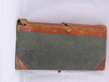
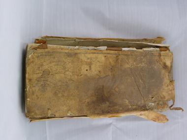
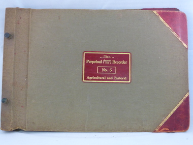 Warrnambool and District Historical Society Inc.
Ledger, Ledger and Correspondence (Swinton), 1930s
... William died his son Robert became the first managing director... William died his son Robert became the first managing director ....1 This is a ledger which was originally printed for the recording of agricultural and pastoral sales but has been used by the Warrnambool firm of Swintons Pty Ltd. to record sales of farm products and machinery from 1934 to 1945. .2 These are 13 items of correspondence, receipts, insurance documents, agreements etc. associated with the Warrnambool business firm of Swintons Pty Ltd. These were contained within the ledger referred to above. William and Ann Swinton migrated to Australia in 1854 and William Swinton worked as a builder and carpenter for a decade, erecting many buildings in the Warrnambool area, including the Wangoom Presbyterian Church. In 1865 he opened a shop in Timor Street, Warrnambool selling groceries, glassware and china. In 1888 the business was known as William Swinton and Sons. Branch stores were opened in Wangoom, Cudgee, Nullawarre, West Warrnambool and South Warrnambool. When William died his son Robert became the first managing director of Swintons Pty Ltd. In 1934 the business split in two with George Swinton and Sons selling furnishings, clothing and glassware and Swintons Pty Ltd selling produce, hardware and seeds. Today the Swinton family still operates a furniture and bedding store in Timor Street. This ledger and the accompanying paper material are of considerable importance as they are associated with the Swinton businesses in Warrnambool. The ledger contains lists of customers of the Swinton business in the 1930s and 40s and provides names, addresses and the cost of the product sold. This is very useful to researchers. The current Swinton business in Timor Street is the oldest family business in Warrnambool and, with the Swinton name associated with businesses in Timor Street for 152 years, is among the oldest family businesses in Australia..1 This is a hard cover ledger. It is beige-coloured with red leather edging on the corners and a red and gold label on the front cover. The pages are held in the folder with metal studs. The pages are white with red and blue printed lines and red leather tabs numbering 1 to 9. The entries are handwritten in blue and black ink. The ledger cover is slightly scuffed. .2 These are 13 items of correspondence from the 1930s and 40s. There is both handwritten and printed material. ‘The Perpetual Income Tax Recorder. No 5. Agricultural and Pastoral’. swinton family warrnambool, history of warrnambool