Showing 310 items
matching town allotments
-
 The Beechworth Burke Museum Research Collection
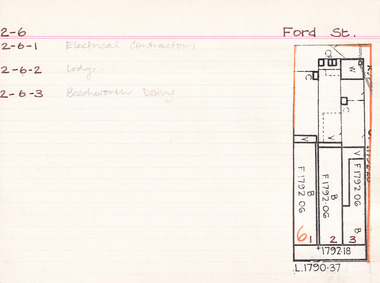
Card - Index Card, George Tibbits, Ford Street, Beechworth, 1976
... Property - Ford Street, Beechworth - Section 2, Town..., Town Allotment 6 - (Note: also 2-6-1 Electrical Contractors, 2 ...Property - Ford Street, Beechworth - Section 2, Town Allotment 6 - (Note: also 2-6-1 Electrical Contractors, 2-6-2 Lodge and 2-6-3 Beechworth Dairy) - 100' x250' Ownership details and history - 28 Oct 1853 - W.H. Neuber 1861 - Galbraith, Andrew - Faulkner George, unlisted, J.S. Clark. land 22'x165', shop 32'x20' glass + deal fr. 2 stories, WB + sh. Bakery 25'x20' slabs + bark. Stable 20'x10' WB + do. 1861 - Steel, William, unlisted, J. Manson. land 11'x140' shop 10'x33' plate glass & cedar front, slabs + sh. Back 10'6"x34' WB + sh. 1861 - Joel, Abraham, unlisted, J. Manson, land 11'x140' shop 10'x33' plate glass + cedar front, slabs + sh. bark, 10'6"x34' WB + do. 1861 - J. Manson, unlisted, same, land 22'x25' (in rear) stable 14'x14' slabs + bark 1861 - George Gammon, unlisted, same, land 22'x165' shop 14'x31' glazed front. deal + WB slabs + sh. Kitchen 15'x12' store in rear 20'x10' do + bark 1863/4 - Eveleigh, J.L. (A. Galbraith in '63-'63) J.S. Clark land + prem as 1861. 1863/4 - Hall, Algernon, J. Manson. land + prem as 1861 1863/4 - Faulkner, baker & confectioner, J. Manson, land + prem as 1861 1863/4 - Manson, John as 1861 1863/4 - Gammon as 1861, Kitchen 15'x12' bk. resid. 24'x12' 1866 - Raphael, Julius, Tobias, Sally, tobacconists, J.S. Clark, land 22'x165 shop 20'x38' bk. bldg. glass fr. + sh. rf. Kitch. in rear 14'x12' WB = sh. Do. Stable 20'x10' slabs + bark. £115 1866 - Cunningham, James & Robert, ironmongers, John Manson, land 22'x165' shop 20'x33' plate glass + cedar fr. slabs + sh. rf. prem in rear 21'x34' WB + sh. rf. £110 1866 - Gammon, George, Druggist, same. land 22'x165' prem. 30'x20' + 24'x12' bk. bldg. 2 stories with plate glass + cedar shop front + sh. rf. Kitchen 15'x12' WB + sh. rf. 1871 - Brown, John, Barber etc. J.S. Clark. land + prem as 1866 £75 1871 - Cunningham, J&R, ironmongers, same. land + prem as 1866 + stable 13'x8' slabs + bark £96 1871 - Gammon, G. Druggist, same land + prem as 1866 £144 1876 - Walton, Wm. Tailor, Mary Clark. prem as 1866 exc. kitch 16'x12' + 20'x10' 1876 - Cunningham, J&R, ironmongers, same land 22'x165' prem 20'x30' deal fr. bk walls sh. roof Do. in rear 34'x21. WB + sh. rf. stable 20'x20' WB + ir. rf. £90 1876 - Gammon, George, Chemist, same land + prem as 1866 exc. no. 24'x12' bk £120 1884 - Armstrong, John, Draper, Mary Clark. shop 1884 - Cunningham Js. Ironmonger, same shop 1884 - Gammon, G. Chemist, same, shop + dwelling 1889 - Armstrong, as above £45 1889 - Cunningham, JS. as above. Cunningham, J&R, shop, prem + land £70 1889 - Gammon, G. Chemist, smae shop, dwelling pr. l. £80 1899-1900 - Armstrong. One shop owned, other ....? one 1900-1901 - Armstrong. double shop 1900 - Armstrong, John, draper, same shop + store £110 1900 - Bowen, Wm Johnston, Chemist, Kate Gammon, Sh. DW + L £65 1906 - Armstrong, Draper, same S+L £110 1906 - Bowen, Wm. Johnston, Chemist, Kate Gammon, shop, prem + land £65 Sect. 2, Town Allot. 6 - Note: 2-6-1 Electrical Contractors, 2-6-2 Lodge and 2-6-3 Beechworth Dairy Architectural Index Card - Brian Pump and Tony Dugan - Photographers beechworth, george tibbits -
 The Beechworth Burke Museum Research Collection
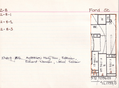
Card (Series) - Index Card, George Tibbits, 39 Ford Street, Beechworth, 1976
... Property - 39 Ford Street, Beechworth - Section 2, Town... 2, Town Allotment 8 - 100' x 250' Ownership details ...George Tibbits, University of Melbourne. Faculty of Architecture, Building and Town & Regional PlanningIndex system that support the research for Beechworth : historical reconstruction / [by] George Tibbits ... [et al]Arranged by street names of BeechworthEach index card includes: street name and number of property, image of property, allotment and section number, property owners and dates of ownership, description of the property according to rate records, property floor plan with dimensions.beechworth, george tibbitsbeechworth, george tibbits -
 The Beechworth Burke Museum Research Collection
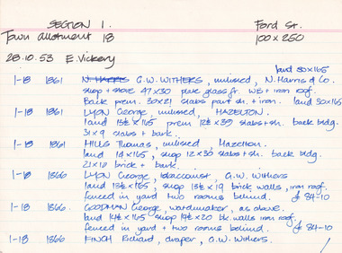
Card (Series) - Index Card, George Tibbits, Ford Street, Beechworth, 1976
... Property - Ford Street Beechworth - Section 1, Town..., Town Allotment 18 - 100' x 250' Ownership details and history ...George Tibbits, University of Melbourne. Faculty of Architecture, Building and Town & Regional PlanningIndex system that support the research for Beechworth : historical reconstruction / [by] George Tibbits ... [et al]Arranged by street names of BeechworthEach index card includes: street name and number of property, image of property, allotment and section number, property owners and dates of ownership, description of the property according to rate records, property floor plan with dimensions.beechworth, george tibbitsbeechworth, george tibbits -
 The Beechworth Burke Museum Research Collection
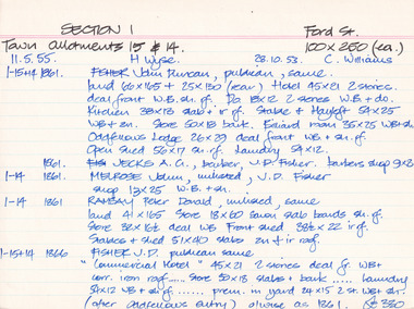
Card - Index Card, George Tibbits, Ford Street, Beechworth, 1976
... Property - Ford Street Beechworth - Section 1, Town..., Town Allotment 14 & 15 - 100' x 250' each Ownership details ...Property - Ford Street Beechworth - Section 1, Town Allotment 14 & 15 - 100' x 250' each Ownership details and history - 28 Oct 1853 - C. Williams - 11 Nov 1855 - H. Wyse 1-15&14 - 1861 - Fisher, John Duncan - publican, same. Land 66'x165' + 25'x130' (rear) Hotel 45'x21' 2 stories, deal front WB. sh. rf. Do 18'x12' 2 stories WB & Do. Kitchen 38'x13' slab + ir rf. Stable & Hayloft 54'x25' WB & sh. Store 50'x18' bark. Billiard room 35'x25' WB + sh. Oddfellows Lodge 26'x29' deal front WB + sh. rf. Open shed. 56'x17' sh. rf. Laundry 54'x12'. 1861 - Jecks A.G. barber, J.D. Fisher barbers shop 9'x8' 1-14 - 1861 - Melrose, John, unlisted J.D. Fisher shop 13'x25' WB + sh. 1-14 - 1861 - Ramsay, Peter Donald, unlisted, same, land 41'x165' store 18'x60' sawn slab boards sh. rf. store 32'x 16'6"deal WB Front Shed 38'6"x 22' ir rf. 1-15+14 - 1863/4 J.D. Fisher, Hotel as 1861 except store 50'x18' is detached and a shop above De Jecks & Kaliton of a 2 storey residence. 1863/4 - Jecks as above 1-14 - 1863/4 Ramsay - as 1866 1-14 - 1866 - Fisher J.D. - publican, same, "Commercial Hotel" 45'x21' 2 stories deal fr. WB+ corr. Iron roof..... store 50'x18' slabs + bark .... laundry 54'x12' WB + sh. rf. ..... prem. in yard 24'x15' 2 stories WB = sh. (after Oddfellows entry) 0/wise as 1861. £330 1-14 - Jecks A.G. barber, J.D. Fisher, barbers shop 9'x8' £28 1-14 - 1866 - Muirhead, George, Tailor, J.D.Fisher prem 13'x12' WB + Sh. £26 1-14 - 1866 - Ramsay P.D. Spirit dealer, same land 41'x165' front prem 23'x54' bk & ir. rf. Do in rear 32'x16'6" deal fr. WB + sh. rf. Do 8'x8' do---do. Stables + shed 51'x40' slabs, sh+ir. rf. (as1861) £35 1-15+14 1871 - Tanwell, Thomas, publican, same - Hotel as above except. Kitchen 40'x15' bk+iron roof as 1863/4 1861 1-14 - 1871 - Jecks, A.G., T. Tanswell, shop 11'x9' £15 1-14 - 1871 - Goodwin, George, watchmaker, T. Tanswell, sh. 12'x11' £19 [these two were actually entered before 1-14+15] 1-14 - 1871 - Scott, Robert, Wine & Spirit Merchant, P.D. Ramsay land 41'x165' deal fr. WB + sh. rf. Stable & shed 51'x40' slabs + iron roof. 1-15+14 - Tanswell, Thomas, publican, same, land 66'x135' + 25'x130' Hotel front buildings. 65'x35' brick, Back do. 42'x30' brick 2 stories iron roof. Kitchen 40'x15' bk. iron roof. Club room 26'x29' WB. sh. rf. Billiard room 35'x25' WB ir. rf. Prem in yard 24'x15' 2 stories WB sh. rf. Laundry 54'x12' WB sh. rf. Store 50'x18' slabs bark rf. Stables 54'x25' WB sh. rf. Shed 56'x17' £250 1-14 - 1876 - Jecks, A.G. barber T. Tanswell shop £15 1-14 - 1876 - Tanswell, T. publican, same, shop & room in rear £20 1-14 - 1876 - Crawford, Hiram Allen, Connelly, Michael, coach proprietors, Beechworth U.S. Council. Weighbridge £10 1-14 - 1876 - Crawford & Connolly, as above, T. Tanswell. prem as 1871. "23'x55'" & no deal fr. ou prem in rear £52 1-15+14 - 1884 - Tanswell E. Tanswell T. Hotel as above, hotel, billiard clubrooms etc. 1-14 - 1884 - Crawford H.A. - Jackson P.W. - McCurdy W. coach props., B.U.S.C., Weighbridge 1-15+14 - 1884 - Crawford H.A. coach props, T. Tanswell, Commercial stable (at rear) 1-14 - 1884 - Crawford H.A. coach prop, same, office, store, cellar & prem. 1-15+14 - 1889 - Tanswell, Edward. Hotel keeper, T. Tanswell, Comm Hotel Billiard Club + sample rooms, prem + land £175 1-15+14 - 1889 - Crawford, H.A. - Connolly, Thomas - McCurdy, William, coach props, same, Stables, Coach sheds, prems + land £80 1-14 - 1889 - Crawford & Co Ltd., coach props, T. Tanswell, office, store, prem + land £50 1-14 - 1889 - As above. B.U.S.C. Weighbridge £10 1-15+14 - 1900 - Crawford & Co ltd. coach proprietors, excecutors of Tanswell's, stables, offices, coach sheds, factory, land £130 1-15+14 - 1906 - Tanswell, Jane, hotelkeeper, same, hotel, prem + land £150 1-15+14 - 1906 - Tanswell, Jane, Clubrooms, Comm. Hotel £20 1-15+14 - 1906 - Crawford & Co LTD. coach props, Jane Tanswell, stables offices, coach sheds, factory + land £85 Architectural Index Card - Brian Pump and Tony Dugan - Photographers beechworth, george tibbits -
 The Beechworth Burke Museum Research Collection
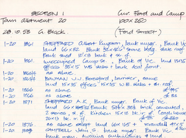
Card (Series) - Index Card, George Tibbits, Cnr Ford and Camp Streets (Ford St), Beechworth, 1976
... - Section 1, Town Allotment 20 - 100' x 250' Ownership details...), Beechworth - Section 1, Town Allotment 20 - 100' x 250' Ownership ...George Tibbits, University of Melbourne. Faculty of Architecture, Building and Town & Regional PlanningIndex system that support the research for Beechworth : historical reconstruction / [by] George Tibbits ... [et al]Arranged by street names of BeechworthEach index card includes: street name and number of property, image of property, allotment and section number, property owners and dates of ownership, description of the property according to rate records, property floor plan with dimensions.beechworth, george tibbitsbeechworth, george tibbits -
 The Beechworth Burke Museum
Photograph, 1910
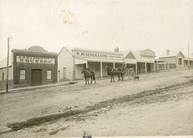
Taken in 1910, this photograph depicts a scene of Bridge road in Newtown, Beechworth. Walking on the road are two men on horseback, one of which is pulling a carriage with a small dog standing beside it. Behind them are a line of small buildings and shops. Small industries began to expand dramatically in Beechworth, particularly during the 1860s, leading to a strengthening of the towns economy. As early as 1853, areas surrounding the waterway known as Spring Creek were surveyed with the intent of mapping out plans for new roads and building allotments. Land was sold and new buildings were erected, creating an expansion of the Beechworth township and retail services. One building shown in this photograph is Straughair and Duncan's Beechworth Foundry. This business was established in 1858 through the partnership of Mark Straughair and John Duncan. It dealt mostly in the manufacturing of castings and mining machinery, receiving orders from all over the Ovens district. The Business eventually collapsed after the deaths of Straughair in 1882 and Duncan in 1896 but was reopened by W.H. Phillips in 1905. The two other buildings are both associated with the name McKenzie. Evidence suggests that the McKenzie family has a long association with the town of Beechworth. This photograph is historically significant as it provides insight into the nineteenth and twentieth century industrial expansions that happened in the area of Newtown, leading to the urbanisation of Beechworth. Black and white rectangular photograph printed on matte photographic paper mounted on card.Reverse: Newton / 1997.2648 / 33 Newton Beechworth / 84-219-1 / McKenzies / BMM3055 / newtown beechworth, bridge road, 1910, j. duncan, r. mckenzie, m. straughair, industrial growth, ford street, beechworth foundry, straughair and duncan, mckenzie and sons grainstore, mckenzie family store -
 Warrnambool and District Historical Society Inc.
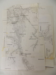
Document, Wollaston sale, 1919
This is a poster advertising the sale of part of the Wollaston Estate in Warrnambool in 1919. The sections for sale were Allotments 1, 18 and 19 which included the Wollaston Homestead. The original Wollaston property of 679 acres was selected by Thomas Manifold in the late 1840s. This land, on the northern side of the Merri River, near the Woodford Road was three kilometres from the Warrnambool town. The first farmer we know who leased the property was William Simpson. Walter Manifold inherited the property and he took it over in 1884. The swing bridge he built in 1890 still stands today. In 1919 the Closer Settlement Board of Victoria acquired Wollaston and 17 lots were sold to returned soldiers for farming purposes. By 1930 there were only five soldier settlers remaining. In 2009 further subdivision took place with lots sold for residential purposes. The homestead allotments were sold separately in 1919 with various owners of the homestead itself recorded since that time. This poster is of interest as it shows the areas of the Wollaston Estate which were sold in 1919. The history of this estate is well-documented and of importance in the history of Warrnambool. This is a sheet of paper with red and black printing and a map of the Wollaston Estate which is photo-lithographed. The sheet has been folded three times. It has some small tears at the top of the page. wollaston, history of warrnambool, walter manifold -
 Kiewa Valley Historical Society
Parish Maps - Kiewa Valley
... the Kiewa Valley was divided up into allotments for town dwellers ...The Parish Maps show how the Counties were divided into allotments for buyers. On one the original owners are named and the sizes of their properties given. The reference numbers enable individuals research the history of the property. The other is on a smaller scale giving only the allotment numbers. The map with the names gives information on the early settlers of the Kiewa Valley. They show how the Kiewa Valley was divided up into allotments for town dwellers and farmers and enables further research.Two copies of Parish Maps of the towns in the Kiewa Valley. One gives the original owners and the other the reference numbers of the allotments.kiewa valley. parish maps. land owners -
 Warrnambool and District Historical Society Inc.
Book, Subdivision No 1 to 1420, 1930s
This is an exercise book listing subdivisions in Warrnambool from 1935 to 1977. There are 1420 entries. It gives details of the subdivisions – plan number, street, section number, allotment number, date, owner, solicitor and Titles Office number. The book is completely filled and today this information would be held in the Warrnambool City Council offices per electronic data storage. Warrnambool, founded in 1847, became a Municipality in 1856, a Borough in 1863, a Town in 1883 and a City in 1918. Subdivisions of land in the city continue to be made regularly for housing and business purposes.This book is of great historic interest because it details the subdivisions in the City of Warrnambool from 1935 to 1977. It shows the continuing growth of the city, particularly after World War Two. It will be a very useful resource for researchers. This is an exercise book with a black cardboard cover and red binding. It contains a list of City of Warrnambool subdivisions from 1935 to 1977. The cover and some of the pages are torn and ragged and the binding has come apart and has been glued together in places. The pages are ruled with blue and red lines. The pages contain handwritten material in black and blue ink. Front Cover: ‘Subdivions(sic), Nos 1 to 1420’ Inside Front Cover: ‘City of Warrnambool Subdivisions’ warrnambool city council, warrnambool subdivisions -
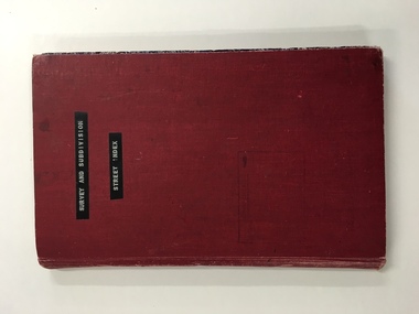 Warrnambool and District Historical Society Inc.
Register, Survey & subdivision street index, 1930s
This is a book with the City of Warrnambool surveys and subdivisions listed under the street names. It covers the period from 1938 to 1975. The information is listed under the headings of plan number, street name, section, allotment, date and remarks. The information contained therein would now be held as electronic data in the Council Records Department. Warrnambool, founded in 1847, became a municipality in 1856, a Borough in 1863, a Town in 1883 and a City in 1918. This book is of considerable interest because it lists Warrnambool streets from 1938 to 1975 and gives details of the subdivisions and surveys during that time. It will be very useful for researchers. This is a foolscap-size hard-cover book with a red cover with a mottled-blue pattern paper inside the covers. It has 95 pages with ruled red and blue lines. It has a handwritten alphabet index throughout the pages. The contents are handwritten in blue, green and black ink. The inside binding has been mended with adhesive tape and one page is loose. The book lists subdivisions in the City of Warrnambool under the heading of the street names and covers 1938 to 1975. The cover is somewhat grubby.Front Cover (in plastic tape): ‘Survey and Subdivision. Street Index’warrnambool city council, warrnambool streets and subdivisions -
 Warrnambool and District Historical Society Inc.
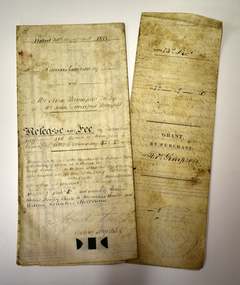
Legal record - Two documents regarding purchase and sale of land, George Barber, Port Fairy solicitor, early 1850s
Thes two documents deal with the purchase and sale of land near Warrnambool by Thomas Simpson. The first document, called a Grant by Purchase, is dated 1852 and shows that Thomas Simpson purchased from the Crown, Allotment 146 (22 acres two roods) adjoining the property of Wollaston on the Merri River and the Mortlake Road, north of Warrnambool. The cost was 90 pounds. The second document is dated 1853 and shows that Thomas Simpson sold this Merri River allotment of 22 acres to Eliza Bromfield, in conjunction with her husband, John Davenport Bromfield, for the sum of 110 pounds. The property of Wollaston was owned by the Manifold family and in the 1850s was leased to William Simpson, the brother of Thomas who had an adjoining property called Wooramoota. John Davenport Bromfield was a Colac farmer who played a prominent part in the early history of that town. His brother James Astley Bromfield, an early chemist in Warrnambool is important in Warrnambool's history.These two items are of considerable significance because they are amongst the earliest legal documents we have connected to Warrnambool's history and because they concern three early pioneers of the district. They also have a connection to Wollaston, an important early property in the Warrnambool district..1 A piece of light parchment paper, stained with age and folded in three places. It contains printed and handwritten material, a copy of a signature and a white seal. .2 A piece of parchment paper folded in half and then folded again in two places. It contains ruled red lines, handwritten material in black ink and the remains of a red seal. The top of the first page has a cut-out fluted pattern.wollaston, john davenport bromfield, thomas simpson, eliza bromfield, george barber solicitor -
 Eltham District Historical Society Inc
Document - Certificate of Title, Landata, Vol. 4930 Fol. 985900, Crown Portion 15 Section 5, Parish of Nillumbik, County of Evelyn, 1925
(Cancelled) Certificate of Title originally issued for Crown Portion 15, Section 5 to Robert David Taylor, of Eltham, County of Evelyn, Farmer, 13 March 1925. It is with this title that the land allotment was subdivided into 48 lots. The title shows the issuance to Robert David Taylor with encumbrance placed upon it by immediate former owner, Hugh Patrick Keogh, a former member for Gippsland and Melbourne Real Estate Agent. Following Taylor's death in 1934 the title passes to his Executors, sons Robert David Taylor of Bible Street, Eltham and William McLelland Vance Taylor of Northcote. The property is then sold to Frank Stokes who develops the Stokes Orchard. Compulsory acquisitions by the Melbourne Metropolitan Board of Works and State Electricity Commission show provisions of easemenst for town water supply and high voltage power transmission lines. Subsequent lots are then sold off with the development of the Stokes Orchard Estate residential development in the mid to late 1970s. A History of the Development of Crown Allotment 15, Section 5, Parish of Nillumbik – Stokes Orchard Crown Allotment 15, Section 5, Parish of Nillumbik (CA15) is a square allotment of 158 acres or approximately a quarter of a square mile. It lies just beyond the eastern end of Pitt Street, south of Nyora Road to the northern end of Eucalyptus Road and extends east from Eucalyptus Road to Reynolds Road. The topography of CA15 is generally steep, sloping up to a hill near the centre of the land, the ridgeline passing through the properties along the southern side of Diosma Road. Eucalyptus Road is a straight north-south road with its northern end at the north west corner of CA15. Until the end of the 1970s this road was an un-named Government Road and was largely not open to traffic. With residential development in the 1970s the road was constructed, and the council allocated the name obviously in recognition of the predominant species of the local bushland. CA15 was purchased from the Crown by George D’Arley Boursiquot, a prominent Melbourne printer, on 28th October 1852. On November 23, 1922, former Member for Gippsland and Melbourne Real Estate Agent, Hubert Patrick Keogh purchased the allotment then sold it March 13, 1925, to local farmer, Robert David Taylor, a former Shire of Eltham Councillor (1911-1920) and Shire President (1919). Taylor had extensive land holdings stretching west towards Bible Street and Main Road. The Taylor home was situated at the top of the hill in Bible Street at present day 82 Bible Street. At the time of Taylor’s purchase in 1925, CA15 was subdivided into 48 lots that could be described as small rural properties or large residential lots. A typical lot size was one hectare or 2.5 acres. The subdivision created two roads, Nyora Road, and Diosma Road, each following an irregular alignment between Eucalyptus and Reynolds Roads. However, the lots were not sold off separately nor were the roads constructed. The land effectively remained as one parcel for many further years. Robert David Taylor died November 30, 1934, and probate was granted to his son of the same name, Robert David Taylor of Bible Street, Salesman and William McLelland Vance Taylor of 73 Emmeline Street, Northcote, Clerk, with the transfer of the land into their names on July 8, 1935. Frank Stokes worked as a qualified accountant at Kennons leather factory in Burnley, while living at 1 Thomas Street, Mitcham. He suffered from migraines and wanted to return to working the land (he had previously worked on farms and orchards since coming to Australia from England in 1926, both in WA and Vic.). He first travelled to the district by train in July 1942 to find land with the intention to establish an orchard. By chance he met Arthur Bird of Bird Orchard (bounded by Pitt Street, Eucalyptus Road, and Wattle Grove) and they got talking over their common interest. Arthur put Frank up for the night and pointed out the land, 158 acres- part of the Taylor Estate- £900, Crown Allotment 15, Section 5, Parish of Nillumbik (CA15) somewhat diagonally opposite Bird Orchard. Stokes applied through the Riverina Agency to purchase the land who in turn applied for permission from Canberra to sell as there was a new government regulation introduced during the Second World War banning land sales except for immediate production. Stokes obtained a loan on his Mitcham house of £600 @ 5% and paid £450 deposit with quarterly payments of £15 spread over 5 years. Stokes was assisted and advised by Arthur Bird who farmed the neighbouring orchard. In early 1943 Stokes took possession and would catch the train out to Eltham on Fridays after work and began building a hut on the corner of Nyora Road and the Government Road (Eucalyptus Road) for shelter and to lock up tools. He established an orchard on the central western part of the land through the centre of which ran a natural waterway (part of the present-day linear park) and was able to pay a neighbour (Hawkins) to help with clearing and fencing 25 acres, and with a horse and single furrowed plough, planted approximately 2,500 fruit trees - cherries, peaches, plums, almonds, pears, apricots and lemons as well as a few apples and oranges; a massive task. Aerial photographs from the 1940s through to the 1990s clearly show the orchard with most of the larger CA15 site remaining as natural bushland. A huge problem was hares and rabbits eating all the new buds off the tiny trees. As well as laying poison he painted the trees with a mixture of cow manure and lime, often working by moonlight. Procurement of wire and wire netting was difficult because of the war but after much effort he obtained a permit from the Agricultural Department for supplies in March 1944. In February 1945 Stokes applied for a permit to build a “packing shed” as no house building was allowed. It was to be 33 feet x 21 feet and cost £312. It was constructed mostly from second-hand materials, which were hard to obtain, especially iron for roofing. Stokes finished work at Kennons on October 31, 1945, and in March 1946 he sold the family home at Mitcham for £1,230 plus £170 for furniture. On May 15, 1946, title to the CA15 property was issued to Frank Howard Alfred Stokes, Orchardist and Gladys Ethel Stokes, Married Woman, both of Pitt Street, Eltham. The family of five then moved into the very unfinished “packing shed” at Eltham, which was a struggle to weatherproof. Eventually rooms were divided off and lined with hessian bags and whitewashed. Their income was firewood (cut and sold), selling rockery stones and cut Sweet Bursaria. (It was discovered during the 1940s that Sweet Bursaria contained the sunscreen compound Aesculin. The RAAF utilised this compound from Sweet Bursaria during WW2 for pilots and gunners.) The orchard’s first fruit sale was a half-case of Le Vanq peaches in December 1947 for the price of 8 shillings. In 1956 plans for house were drawn and Glen Iris bricks purchased (1956 Olympic Rings variant). The building of the house commenced in 1957 - 12 feet of original packing shed was removed – and was completed in 1959. Water was connected from newly built pressure storage on the property at the end of 1959 and the electricity connection for the first time at 3pm on April 29, 1960. The house remains to present day (somewhat modified) at 1 Nyora Road, home to Nyora Studio Gallery. On occasions, spare remnants of the 1956 bricks have been known to be unearthed in gardens on the estate as they were utilised by Frank Stokes to fill in rabbit holes. On May 26, 1950, a parcel of land was compulsorily acquired by the Melbourne and Metropolitan Board of Works on the hilltop to establish an easement for a high-level service reservoir to augment Eltham’s water supply. The project also included pipe tracks for the necessary water mains. The reservoir has now been superseded by higher level water tanks east of Reynolds Road and its former site is now a public reserve. On November 27, 1964, the State Electricity Commission served notice to compulsorily acquire a further parcel through the eastern part of the land for a major electricity transmission line that augmented supply from the La Trobe Valley to Melbourne. The easement was registered February 11, 1966. The easement was widened July 18, 1969 for a second transmission line to be constructed. In 1971 Melbourne Metropolitan Planning Scheme amendments adopted Nyora Road as the boundary between a residential zone to the north and a rural zone to the south. This determined the future development of the land. In the mid-1970s the Shire of Eltham divided the orchard into numerous rate-able parcel lots, the 48 lots having been established in 1925 and the subsequent rates assessment proved unsustainable for Stokes. He commenced selling lots outside the boundary of the orchard, north of Diosma and South of Nyora. However shortly later the land between Nyora and Diosma Roads and west of the electricity easement was sold and subdivided into residential lots, a housing development by Macquarie Builders and marketed as the Stokes Orchard Estate. New streets were created, and most were named after trees, although one, Stokes Place, commemorates the former owners. The development was undertaken in two stages; Stage 1 (1975) encompassing Scarlet Ash Court, Ironbark Close and Peppermint Grove bounded by Nyora and Eucalyptus roads and Stage 2 (1978) encompassing Stokes Place, Orchard Way, The Crest and The Lookout bound by Nyora and Diosma roads. The developer, Macquarie Builders went bankrupt shortly after the release of Stage 2 leaving many purchasers to fend for themselves and arrange for their own independent builders. There were also difficulties with sewerage for the land immediately south of Diosma Road and so the conventional residential lots were abandoned in favour of larger lots. The development of Orchard Way, The Crest and The Lookout did not proceed as planned and the proposed lots were incorporated into five-acre parcels instead. These included a low-density group housing development by the Graves family and the award winning Choong House (1983) with Gordon Ford developed garden immediately next door situated on the ridge of the hill nestled amongst the original bush, Eucalypt trees and Sweet Bursaria. In 1994, Nillumbik Shire Council applied Significant Environment and Significant Landscape overlays upon the properties on the south side of Diosma Road to ensure protection of this natural bush garden environment. With the arrival of the sewer along Diosma Road in the 1990s, most of these five-acre parcels have since been subdivided multiple times. The Choong house presently sits on a 2.7-acre property, which in 2022 Nillumbik Council nominated for Cultural Significance Heritage protection and is considered potentially significant at State level. The Stokes family were also associated with the Eltham Christian Church. In the 1970s this church had met in temporary premises in Eltham. Lots of the original 1925 subdivision remained south of Nyora Road and a number of these lots were utilized for the Eltham Christian School, which was established by the Eltham Christian Church in 1981. The school operated on this site until 2000. The premises are now used by The Vine Baptist Church. By the mid-1980s the whole of CA15 had been developed for residential and school purposes, except for the sections north of Diosma Road and between the transmission lines and Reynolds Road. Sewerage issues had been resolved for the section north of Diosma Road and in 1987 it was in the process of being subdivided into residential lots. The development coincided with the discovery of colonies of the rare and endangered Eltham Copper Butterfly on the site. This resulted in a community and political campaign to save the butterfly habitat. With the co-operation of the land developer the subdivision was altered to create two bushland reserves in the critical butterfly habitat areas. In the late 1980s the State Government was investigating options for establishing a metropolitan ring road link between Diamond Creek and Ringwood. The chosen route was adjacent to Reynolds Road and so this created a freeze on development of CA15 between Reynolds Road and the electricity easement. The ring road proposal was eventually abandoned, and this part of the land was subdivided into low density residential lots. Diosma Road has been discontinued at the electricity easement and the eastern part incorporated into View Mount Court with access from Reynolds Road. The whole of CA15 has now been developed for residential or associated purposes, ranging from conventional density to quite low density south of Nyora Road. Some remnants of the orchard remain, a few cherry trees on the Graves property and a lone apple tree in Stokes Place. The butterfly reserves comprise significant areas of remnant bushland. Linear reserves through the estate link with central Eltham via the Woodridge linear reserve and with Research along the electricity easement. CA15 as it exists today has a complicated history of rural use, Government acquisition, urban development, and community action. References: • “Stokes Orchard, an incomplete history”; Russell Yeoman with Doug Orford • Correspondence, Beryl Bradbury (nee Stokes) • Aerial Photographs, 1931-1991, Landata (landata.vic.gov.au) • Certificate of Title, Vol. 4930 Fol. 985900 • Plan Number LP 10859 neil webster collection, diosma road, eltham copper butterfly, eucalyptus road, ironbark close, nyora road, peppermint grove, power transmission lines, reynolds road, scarlet ash court, stokes orchard estate, stokes place, woodridge estate, frank stokes, certificate of title -
 Eltham District Historical Society Inc
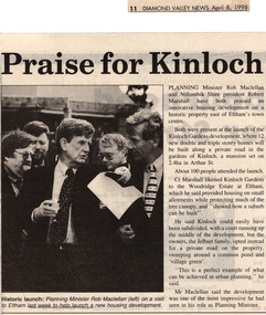
Drawing - Newspaper clipping, Praise for Kinloch, Diamond Valley News, April 8, 1998, p11, April 1998
PLANNING Minister Rob Maclellan and Nillumbik Shire president Robert Marshall have both praised an innovative housing development on a historic property east of Eltham's town centre. Both were present at the launch of the Kinloch Gardens development, where 12 new double and triple storey homes will be built along a private road in the gardens of Kinloch, a mansion set on 2.4ha in Arthur St. About 100 people attended the launch. Cr Marshall likened Kinloch Gardens to the Woodridge Estate at Eltham, which he said provided housing on small allotments while protecting much of the tree canopy, and "showed how a suburb can be built". He said Kinloch could easily have been subdivided, with a court running up the middle of the development, but the owners, the Jelbart family, opted instead for a private road on the property, sweeping around a common pond and 'village green'. ''This is a perfect example of what can be achieved in urban planning,'' he said. Mr Maclellan said the development was one of the most impressive he had seen in his role as Planning Minister Picture - Historic launch: Planning Minister Rob Maclellan (left) on a visit to Eltham last week to help launch a new housing development.Digital file only; created from scan undertaken by EDHS of item on loanarthur street, eltham, graeme gunn, houses, ian jelbart, jelbart property, kinloch gardens, rob maclellan, robert marshall, woodridge estate -
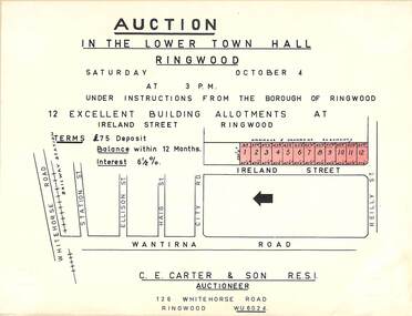 Ringwood and District Historical Society
Flyer, Building Allotments Auction Notice - Ireland Street, Ringwood, Victoria - circa 1960
Notice attached to light cardboard backing advertising auction in the lower town hall, Ringwood, at 3pm, Saturday October 4 (1958?) for 12 building allotments in Ireland Street, Ringwood. Locality plan with red shading highlighting sites for auction in Ireland Street under instructions from the Borough of Ringwood. (Agent) C.E. Carter & Son, 126 Whitehorse Road, Ringwood (Phone) WU 6024. -
 Ringwood and District Historical Society
Flyer, Auction Sale Advertisement - Ringwood Station Estate, Ringwood, Victoria - 1919
Folded double-sided brochure advertising auction of residential allotments on Saturday, 11 October, 1919, with town photographs including residence of Mr. and Mrs. Williams on the estate, location map, terms of sale, and summary of local features and services.Subdivision includes Bedford Road and Williams Grove (later Lena Grove). (Agents) Knight & Harwood, 315 Collins Street, Melbourne, Phones Central 10615, 10616, in conjunction with Godbehear & Co., Local Agents, Ringwood, Phone Ringwood 49. -
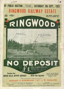 Ringwood and District Historical Society
Flyer, Subdivision Advertisement - Ringwood Railway Estate Public Auction - 1923
Refer also to Reg. No. 5185 for Ringwood Railway Estate final section release (August 1924)Folded double-sided brochure advertising 85 residential allotments and brick cemented villa - Ringwood Railway Estate Public Auction on Saturday 8th September, 1923, with town photographs, location map, terms of sale, and summary of local features and services.Subdivision includes Whitehorse Road, Bon View Avenue, Grant Crescent, Heatherbrae Avenue, Burwood Avenue, and Sherbrooke Avenue. (Agents) Knight & Harwood, 315 Collins Street, Melbourne, Phones Central 10615, 10616, in conjunction with J.B. McAlpin, Opposite Railway Station, Ringwood, Phone Ringwood 7. -
Glen Eira Historical Society
Letter - Rosstown Railway
This file contains four items: 1/A black and white photocopy of a letter dated either 07/08/1889 or 09/08/1889, from Robert Lundon to an unidentified recipient discussing an agreement reached between the author – on behalf of the recipient – and Soon Hang Hi in regard, in regards to the allotment known as Webber’s. The agreement is outlined in the letter in what appears to be Chinese characters, and includes the marks of Robert Lundon and Soon Hang Hi. File note from Joy Wu states that the calligraphy is not Mandarin or traditional Chinese. 2/Three sheets of hand-written working notes with information taken from the Victorian Government Gazette on THE ROSSTOWN AND MURRUMBEENA LAND COMPANY LIMITED, THE ROSSTOWN JUNCTION RAILWAY AND PROSPERITY COMPANY LIOMITED, and THE ROSSTOWN JUNCTION, ELSTERNWICK, AND OAKLEIGH RAILWAY COMPANY LIMITED, covering dates between 1887 and 1894. The notes concern meetings and creditors claims relevant to the companies, with reference numbers for the information source. Date and author of the notes are not recorded. 3/A black and white photocopy of the a partial map of the Rosstown Railway and surrounding area, undated. The map includes the names of landholders in the areas of Brighton, Garden Vale and Elsternwick, as well as other railway lines present in the region. 4/A fold-out map and guide of the Rosstown Rail Trail, including a brief general history of Caulfield as well as a more extensive biography of William Murray Ross and the Rosstown Railway. The map marks and describes significant sites along the trail, including photographs of some of these sites, provided by DF Jowett.documents, correspondence, webber’s, lundon robert, chinese characters, ethnic communities, signatures, text, settlements, taxes, fraser john grieves, lovell r.h., price davies, meetings, communication activities, soon hang hi, commercial events and activities, the rosstown and murrumbeena land company limited, victorian government gazette, bulmer richard, parry john, osment henry, shareholders, creditors claims, the rosstown junction railway and property company limited, finch and best, lawyers, the rosstown junction elsternwick and oakleigh railway company limited, cameron w.c., phillips p.d., garden vale, elsternwick, elsternwick railway station, rosstown, rosstown railway, thomas street, bay street, kooyong road, melbourne and brighton railway, hawthorn road, bambra road, caulfield and frankston railway, booran road, grange road, koornang road, murrumbeena road, north road, north road railway station, east brighton railway station, south road, railway routes, railway lines, railways, land transport, murphy j., caulfield, hamilton t.f., dane p., holloway, webb, ailee john, payne t.b., brodie chas, dane john, o’neil h., mccombie john, mcmillane a., smyth c.d., cooper, ebden, landholders, jeffrey j.d., gill j., balcombe a.e., cooper h., mcnab j., white j., sutherland j., greeves a.f.a., newton m.c., chamley f.b., fowler j., inglis p., grant t., stooke j., swanson g., cochrane c., adams e.b., mccombie thas, keyes robert, brighton cemetery, burials grounds and graveyards, war-ein road, were j.b., holland j., mcmahon c., winter t.l.m., dendy henry, mitchell w., jackson s., were j.e., wickham francis dawe, bryant jane, east brighton railway station, railway stations, maps, allotments, land titles, roads and streets, rosstown rail trail, city of glen eira, tourism, trains, tourism information bureaus, tours, pamphlets, elsternwick railway park, oakleigh junction, princes park, ee gunn reserve, packer park, sites, jowett d.f., weickhardt i.g., return to rosstown: railways land sales and sugar beet ventures in caulfield, land sales, walking trails, ross william murray, transport objects, locomotion, walking, cycling, driving, sports, country mansions, people, caulfield john, builders, construction and demolition workers, occupations, careers, professionals, topography, geology, landforms, horticulture, market gardens, primary industry workers, city of caulfield, mood kee, pennington harold, annual general meetings, caulfield town hall, glen eira city council, carnegie, carnegie station, rosstown station, people by circumstance, migrants, sugar beet, sugar beet mill, sugar beet industry, mills, factories, sea beach lines, bent thomas, parliamentary representatives, neville street, miller street, lemann’s swamp reserve, koornang park, cane sugar industry, breweries, rabbit processing plants, health establishments, hospitals, food production establishments, abattoirs, thieves, social problems, vagrants, theft, squatting, financial economics, debt, finance industry, insurance companies, company managers, bentleigh, ross leila, the grange, leila road, wild cherry road, financial trouble, mortgages, gisborne street, archibald street, riddell parade, victoria railways, glen huntly road, clarence street, college street, gladstone parade, parrell street, aileen avenue, seaview street, drion estate, land subdivisions, dover street, sussex street, landfill, marara road, booran road, woodville avenue, dorothy avenue, ormond park, royal avenue, ormond railway station, oakleigh road, melten avenue, miller street, munro avenue, lord reserve, neerim road, toolambool road, the rosstown hotel, rosanna street, murrumbeena crescent, commercial establishments, the national bank, rosstown road, kangaroo road, poath road, freda street, hughesdale kindergarten, oakleigh council, hughesdale community centre, civic establishments, galbally reserve, plaques, warrigal road, out and about brochures -
Federation University Historical Collection
Map, Town of Buninyong, 1927, 09/1927
The date of this map is September 1927 revised from the original 1910 map. Buninyong was created a district on 09 July 1858, proclaimed a Shire on 16 February 1864, and the Buninyong Borough united on 01 October 1915.Township plan of the Town of Buninyong showing government roads and crown allotments. Earlier detail pencilled on (commercial buildings, etc) appears to be from an 1850 survey. Scale: 4 chains to 1 inch (1:3168)buninyong, map, buninyong botanical gardens, tannery dam, buninyong reservoir, chapel school, rev. hastie -
 City of Moorabbin Historical Society (Operating the Box Cottage Museum)
Photograph, B/W Laminated of August Rietman Family c 1918, c1918
August Rietmann 1877-1951 and his wife Frieda 1878-1942 leased the Box Cottage in 1917 and raised 2 children Stefanie 1918-2006, and William 1920– 1997. August was a Monumental Mason / Potter / Sculptor and he was employed at Corbens Ltd Clifton Hill, to make the War Memorials for many towns post WW1. August purchased the property 1935,and established a pressed concrete business using the cottage as a workshop and storeroom After August died in 1951, William, his son, continued to work in the business from the site until the land was sold to Lewis Co. Ltd Timber Merchants in 1970. Rietman's Landscaping Ltd , managed by William's family, moved to Bay Road Highett 1953 and later to Carrum. The original small, pioneer cottage was built in the late 1840s to early1850s, by an unknown pioneer. It was located on part of a 30 Acre allotment that was originally part of Dendy’s Special Survey granted in 1841. The doors and window sashes, (made of red deal joinery timber), as well as the brass locks and fittings, are from the original cottage, and were imported from England. The fire-place bricks are from the original cottage, and are sun-dried, (not kiln fired), and are hand-made. Convict marks can be seen on two bricks. There is a small display of external cladding shingles from the original pioneer cottage. These shingles were hand-split, and most likely made from locally collected timber The nails included in this display were used to fasten the shingles on the original cottage, and are also hand-made. The cottage was occupied by William Box and family from 1865 until 1914 when it was sold to August Rietman . The enamel nameplate, “Colonial”, on the wall of the cottage, was the name chosen for the original pioneer cottage by Mr August Rietman, when he purchased the property in around 1915, for 1200 Pounds approximately. In 1974 Mr Lewis, a timber specialist, found the dilapidated building on property he had recently purchased in Jasper Rd and suggested it be reconstructed and relocated. Moorabbin Council agreed and the cottage was rebuilt just about 250 metres from its original site. The cost of the rebuild was met by 'Victoria's 150th Committee, plus a small grant from the City of Moorabbin, and Mr Laurie Lewis donated much of the timber for the reconstruction. The re-constructed cottage plan has followed faithfully the original dimensions, and plan of the original pioneer cottage, and as many original items from that cottage’s long occupation have been incorporated. The photographs in Album 1 record the progress of the reconstruction from February 1984 to the First Public Open Day November 18th 1984After the death of Elisa Box in 1914 the house was leased to August Rietmann, a potter / sculptor who with his wife Fieda raised their family there 1917 - 1951. Stefanie Rennick nee Rietman lived at the house until she left to study teaching 1937. August's son, William Rietman and family managed Rietman's Landscaping Ltd after moving to Bay Road Highett 1953 and later to Carrum. The Lewis Timber Company Ltd purchased the land with The Cottage c1970. i) A laminated, black and white, photograph of August Rietmann and Family c1918 at Box Cottage, Ormond, Molly the house cow is in foreground ii) Colour photograph of Rietman's Landscaping Ltd. Bay Road Highett c 1990brighton, moorabbin, cottages, pioneers, ormond, colonial, mckinnon, dendy henry, box william, box elizabeth, reitman august, convicts lewis timber co. ltd., deam h, museums, box alonzo, smith a, rietmann august, rietman august, rietmann frieda, rietman frieda, stonnington city town hall, war memorials, world war 1 1914-1918, rietman stefanie, rennick stefanie, francis stefanie, rietman william, rietman ray, mountford paul, malvern city town hall, box cottage museum ormond, joyce park ormond, rietman's landscaping pty ltd, bay road highett, macrobertson pty ltd, coleraine soldier memorial 1921, dendy, rietman agust, convicts, macrobertson, war memorial -
 Bendigo Historical Society Inc.
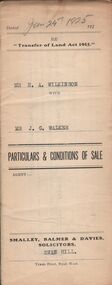
Document - H.A. & S.R. WILKINSON COLLECTION: CONDITION OF SALE
Conditions of sale issued by Smalley, Balmer & Davies solicitors, Swan Hill and dated 24th January 1925 between H. A. Wilkinson as seller and J. G. Walker as buyer. Particulars and conditions of sale of freehold land, particulars: the surface and down to a depth of fifty feet below the surface of all that piece of land being part of Crown Allotment 6 Suburban Section 2 town of Swan Hill, Parish of Castle Donnington County of Tatchera and being the whole of the land described in certificate of title volume 4390 folio 877911. Price 400 pounds.organization, business, h.a. & s.r wilkinson real estate -
 Bendigo Historical Society Inc.
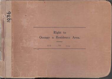
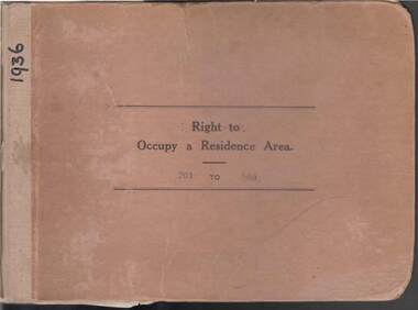
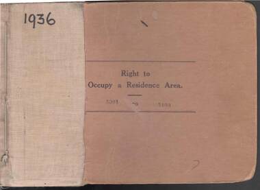
Book - RIGHT TO OCCUPY RESIDENCE AREA COLLECTION: REGISTER 1936
... , Date of Right , Description of Land , Allotment, Section, City... of Right , Description of Land , Allotment, Section, City, Town ...COLLECTION OF RIGHT TO OCCUPY A RESIDENCE AREA -LAND (RESIDENCE AREAS ) Act 1935 / thick cardboard book -cloth and string binding / written on front in texter '1936' / numbers 401 to 500 / inside - stubs of documents showing Granted to , of, period, Date of Right , Description of Land , Allotment, Section, City, Town, Borough, Township of, Parish of, Authorised Person . Rubber stamps show The interest of this Right has been transferred to / note on Bendigo Historical Society Catalogue Sheet dated 12.6.2008 All buts completed and original application forms removed. Note -forms were originally in triplicate on one page with serrations for removal of two parts; butts remain. Residence areas in Central Goldfields / form for butt 454 is included.Bendigo City Council - Acquisition 1990organization, government, bendigo land office, right to occupy a residence area -land (residence areas ) act 1935 -
 Bendigo Historical Society Inc.
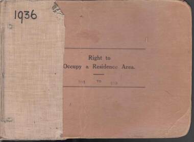
Book - RIGHT TO OCCUPY RESIDENCE AREA COLLECTION: REGISTER 1936
... , Date of Right , Description of Land , Allotment, Section, City... of Right , Description of Land , Allotment, Section, City, Town ...COLLECTION OF RIGHT TO OCCUPY A RESIDENCE AREA -LAND (RESIDENCE AREAS ) Act 1935 / thick cardboard book -cloth and string binding / written on front in texter '1936' / numbers 301 to 400 / inside - stubs of documents showing Granted to , of, period, Date of Right , Description of Land , Allotment, Section, City, Town, Borough, Township of, Parish of, Authorised Person . Rubber stamps show The interest of this Right has been transferred to / note on Bendigo Historical Society Catalogue Sheet dated 12.6.2008 All buts completed and original application forms removed. Note -forms were originally in triplicate on one page with serrations for removal of two parts; butts remain .Residence areas in Central Goldfields / form for butt N0 331 is included.Bendigo City Council - Acquisition 1990organization, government, bendigo land office, right to occupy a residence area -land (residence areas ) act 1935 -
 Bendigo Historical Society Inc.
Book - RIGHT TO OCCUPY RESIDENCE AREA COLLECTION: REGISTER 1936
... of Right , Description of Land, Allotment, Section, City, Town... of Right , Description of Land, Allotment, Section, City, Town ...COLLECTION OF RIGHT TO OCCUPY A RESIDENCE AREA -LAND (RESIDENCE AREAS ) Act 1935 / thick cardboard book -cloth and string binding / written on front in texter '1936' / numbers 201 to 300 / inside - stubs of documents showing Granted to, of, period, Date of Right , Description of Land, Allotment, Section, City, Town, Borough, Township of , Parish of , Authorised Person. Rubber stamps show The interest of this Right has been transferred to/ note on Bendigo Historical Society Catalogue Sheet dated 12.6.2008 All buts completed and original application forms removed. Note -forms were originally in triplicate on one page with serrations for removal of two parts; butts remain. Residence areas in Central Goldfields.Bendigo City Council - Acquisition 1990organization, government, bendigo land office, right to occupy a residence area -land (residence areas ) act 1935 -
 Bendigo Historical Society Inc.
Book - RIGHT TO OCCUPY RESIDENCE AREA COLLECTION: REGISTER 1936
... , Date of Right , Description of Land , Allotment, Section, City... of Right , Description of Land , Allotment, Section, City, Town ...COLLECTION OF RIGHT TO OCCUPY A RESIDENCE AREA -LAND (RESIDENCE AREAS ) Act 1935 / thick cardboard book -cloth and string binding / written on front in texter '1936' / numbers 101 to 200 / inside - stubs of documents showing Granted to , of, period, Date of Right , Description of Land , Allotment, Section, City, Town, Borough, Township of, Parish of, Authorised Person . Rubber stamps show The interest of this Right has been transferred to / note on Bendigo Historical Society Catalogue Sheet dated 12.6.2008 All buts completed and original application forms removed. Note -forms were originally in triplicate on one page with serrations for removal of two parts; butts remain .Residence areas in Central Goldfields.Bendigo City Council - Acquisition 1990organization, government, bendigo land office, right to occupy a residence area -land (residence areas ) act 1935 -
 Bendigo Historical Society Inc.
Book - RIGHT TO OCCUPY RESIDENCE AREA COLLECTION: REGISTER 1936
... , Date of Right , Description of Land , Allotment, Section, City... of Right , Description of Land , Allotment, Section, City, Town ...COLLECTION OF RIGHT TO OCCUPY A RESIDENCE AREA -LAND (RESIDENCE AREAS ) Act 1935 / thick cardboard book -cloth and string binding / written on front in texter '1936' / numbers 001 to 100 / inside - stubs of documents showing Granted to , of, period, Date of Right , Description of Land , Allotment, Section, City, Town, Borough, Township, of , Parish of , Authorised Person . Rubber stamps show The interest of this Right has been transferred to/ note on Bendigo Historical Society Catalogue Sheet dated 12.6.2008 All butts completed and original application forms removed. Note -forms were originally in triplicate on one page with serrations for removal of two parts; butts remain . Residence areas in Central Goldfields.Bendigo City Council - Acquisition 1990organization, government, bendigo land office, right to occupy a residence area -land (residence areas ) act 1935 -
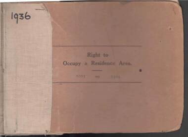
 Bendigo Historical Society Inc.
Book - RIGHT TO OCCUPY RESIDENCE AREA COLLECTION: REGISTER 1936
... , Date of Right , Description of Land , Allotment, Section, City... of Right , Description of Land , Allotment, Section, City, Town ...COLLECTION OF RIGHT TO OCCUPY A RESIDENCE AREA -LAND (RESIDENCE AREAS ) Act 1935 / thick cardboard book -cloth and string binding / written on front in texter '1936' / numbers 5301 to 5400 / inside - stubs of documents showing Granted to , of, period, Date of Right , Description of Land , Allotment, Section, City, Town, Borough , Township of , Parish of , Authorised Person . Rubber stamps show The interest of this Right has been transferred to / note on Bendigo Historical Society Catalogue Sheet dated 12.6.2008 All butts completed and original application forms removed. Note -forms were originally in triplicate on one page with serrations for removal of two parts; butts remain .Residence areas in Central Goldfields.Bendigo City Council - Acquisition 1990organization, government, bendigo land office, right to occupy a residence area -land (residence areas ) act 1935 -
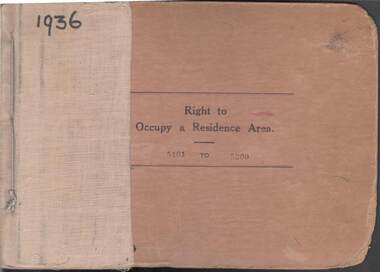
 Bendigo Historical Society Inc.
Book - RIGHT TO OCCUPY RESIDENCE AREA COLLECTION: REGISTER 1936
... , Date of Right , Description of Land , Allotment, Section, City... of Right , Description of Land , Allotment, Section, City, Town ...COLLECTION OF RIGHT TO OCCUPY A RESIDENCE AREA -LAND (RESIDENCE AREAS ) Act 1935 / thick cardboard book -cloth and string binding / written on front in texter '1936' / numbers 5401 to 5500 / inside - stubs of documents showing Granted to , of, period, Date of Right , Description of Land , Allotment, Section, City, Town, Borough , Township of , Parish of , Authorised Person . Rubber stamps show The interest of this Right has been transferred to / note on Bendigo Historical Society Catalogue Sheet dated 12.6.2008 All butts completed and original application forms removed. Note -forms were originally in triplicate on one page with serrations for removal of two parts; butts remain .Residence areas in Central Goldfields.Bendigo City Council - Acquisition 1990organization, government, bendigo land office, right to occupy a residence area -land (residence areas ) act 1935 -
 Bendigo Historical Society Inc.
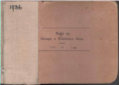
Book - RIGHT TO OCCUPY RESIDENCE AREA COLLECTION: REGISTER 1936
... , Date of Right , Description of Land , Allotment, Section, City... of Right , Description of Land , Allotment, Section, City, Town ...COLLECTION OF RIGHT TO OCCUPY A RESIDENCE AREA -LAND (RESIDENCE AREAS ) Act 1935 / thick cardboard book -cloth and string binding / written on front in texta '1936' / numbers 5201 to 5300 / inside - stubs of documents showing Granted to , of, period, Date of Right , Description of Land , Allotment, Section, City, Town, Borough , Township of , Parish of , Authorised Person . Rubber stamps show The interest of this Right has been transferred to / note on Bendigo Historical Society Catalogue Sheet dated 12.6.2008 All butts completed and original application forms removed. Note -forms were originally in triplicate on one page with serrations for removal of two parts; butts remain .Residence areas in Central Goldfields.Bendigo City Council - Acquisition 1990organization, government, bendigo land office, right to occupy a residence area -land (residence areas ) act 1935 -
 Bendigo Historical Society Inc.
Book - RIGHT TO OCCUPY RESIDENCE AREA COLLECTION: REGISTER 1936
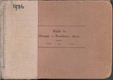
... , Date of Right , Description of Land , Allotment, Section, City... of Right , Description of Land , Allotment, Section, City, Town ...COLLECTION OF RIGHT TO OCCUPY A RESIDENCE AREA -LAND (RESIDENCE AREAS ) Act 1935 / thick cardboard book -cloth and string binding / written on front in texter '1936' / numbers 5101 to 5200 / inside - stubs of documents showing Granted to , of, period, Date of Right , Description of Land , Allotment, Section, City, Town, Borough , Township of , Parish of , Authorised Person . Rubber stamps show The interest of this Right has been transferred to/ note on Bendigo Historical Society Catalogue Sheet dated 12.6.2008 All buts completed and original application forms removed. Note -forms were originally in triplicate on one page with serrations for removal of two parts; butts remain .Residence areas in Central Goldfields.Bendigo City Council - Acquisition 1990organization, government, bendigo land office, right to occupy a residence area -land (residence areas ) act 1935 / / -
 Bendigo Historical Society Inc.
Book - RIGHT TO OCCUPY RESIDENCE AREA COLLECTION: REGISTER 1936
... , Date of Right , Description of Land , Allotment, Section, City... of Right , Description of Land , Allotment, Section, City, Town ...COLLECTION OF RIGHT TO OCCUPY A RESIDENCE AREA -LAND (RESIDENCE AREAS ) Act 1935 / thick cardboard book -cloth and string binding / written on front in texter '1936' / numbers 5001 to 5100 / inside - stubs of documents showing Granted to , of, period, Date of Right , Description of Land , Allotment, Section, City, Town , Borough , Township of , Parish of , Authorised Person . Rubber stamps show The interest of this Right has been transferred to /one stub shows Department of Lands and Survey note on Bendigo Historical Society Catalogue Sheet dated 12.6.2008 All buts completed and original application forms removed. Note -forms were originally in triplicate on one page with serrations for removal of two parts; butts remain .Residence areas in Central Goldfields.Bendigo City Council - Acquisition 1990organization, government, official