Showing 2749 items
matching town houses
-
 Glenelg Shire Council Cultural Collection
Book, William & Robert Chambers, Chambers' Encyclopaedia, Vol. II. BEA-CATA, 1888
Brown leather bound spine with maroon cloth-covered board covers. Gold lettering and gold graphics in six rectangles on spine. Leather corners on outer edges. -
Glenelg Shire Council Cultural Collection
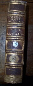
Book, George L. Chalk and Charles MacFarlane and other contributors, The Pictorial History of England, Vol. VI, 1785-1791, 1846
Light brown coloured leather-bound spine and cover corners. Paper-covered board covers with greens red and ochre marbling. Gold lettering and gold graphics on spine. -
 Glenelg Shire Council Cultural Collection
Book, The Pictorial History of England, Vol. II. 1399-1603, 1846
Light brown coloured leather-bound spine and cover corners. Paper-covered board covers with greens red and ochre marbling. Gold lettering and gold graphics on spine. -
Glenelg Shire Council Cultural Collection
Book, George L. Chalk and Charles MacFarlane and other contributors, The Pictorial History of England, Vol. IV, 1688-1760, 1846
Light brown coloured leather-bound spine and cover corners. Paper-covered board covers with greens red and ochre marbling. Gold lettering and gold graphics on spine. -
Glenelg Shire Council Cultural Collection
Book, George L. Chalk and Charles MacFarlane and other contributors, The Pictorial History of England, Vol. III, 1603-1688, 1846
Light brown coloured leather-bound spine and cover corners. Paper-covered board covers with greens red and ochre marbling. Gold lettering and gold graphics on spine. -
 Glenelg Shire Council Cultural Collection
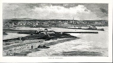
Artwork, other - Illustration Portland Barton's Beach, n.d
Illustration. Taken and cut from a book. Black and White rectangle image on off white paper. Portland from Barton's Beach, looking north west. Panoramic view in background of Portland's town with original buildings. All Saints Catholic Church with spire recognisable. Pier in the Middle right with various structures and a docked ship with sails. Bottom left 3 people launching two canoes at the beach. Wattle Creek or Salt Creek with bridge structure on the middle left. Front: 'VIEW OF PORTLAND' - printed, bottom frame. Signature 2cm in from the left corner of the frame 'CALVERT. SS'portland, bartons beach, portland bay -
Glenelg Shire Council Cultural Collection
Painting - Hand Painted Poster - The Newest Hospital for the Oldest Town, Elsie Rose, 1945, c. 1945
Hand painted poster by Elsie Rose, 1945, 'The Newest Hospital for the Oldest Town'. Black border, yellow background, red printing, pile of brown bricks left hand side, replica on shilling a brick, be a brick and finish the jobelsie rose -
Glenelg Shire Council Cultural Collection
Print - Artist's Impression of Portland Harbour, n.d
Illustration shows an artist's impression of the ultimate development of Portland Harbour. Full colourFront: 'Impression of Ultimate Development of the Port of Portland' - black script bottom mountportland harbour, development, town development, growth -
 Glenelg Shire Council Cultural Collection
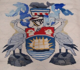
Artwork, other - Tapestry, Tapestry - Town of Portland Coat of Arms, 1996-2004
Made by Portland Fibre Group, 1996-2004: specifically Mary Sharrock, Dot Kelly, Ollie Dellar, Doris Amor and Ede Bailey.Tapestry woven in wool on twine warp. Cream coloured background with pale blue flecks of colour, central motif of coat of arms - features two birds standing on grey platforms to either side of shield. Central to the shield is a masted sailing vessel sitting atop blue and white horizontal lines representing the ocean. Around the sails of the vessel are radiating yellow rays and a blue surrounds representing sunburst against blue sky. The top third of shield shows a pair of sheep heads against a red background. Above the shield is depicted a helmet, crowned with a whale. Blue plumage is shown coming from the helmet and framing the whale.Front: (Weavers' initials, except Ede Bailey, woven into tapestry and are seen on the hem). Back: (no inscriptions)town of portland, textile, tapestry, weaving -
Glenelg Shire Council Cultural Collection
Print - Print, reproduction, F. W. Birmingham, Map of the town of Portland in the colony of Victoria, 1853
Town of PortlandFramed illustration of a map of the Town of Portland from a stone etching published by F.W. Birmingham, Dec.1853. Mounted and framed in stained black timber frame under glass.Front: (no inscriptions) Back: (no inscriptions) -
 Glenelg Shire Council Cultural Collection
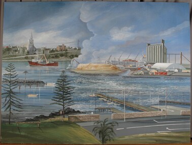
Painting, Untitled (Portland Port), c. 1990
Project to interconnect NSW, Victoria and SA power grid officially opened 30 March 1990. Painting one of several commissioned to mark the link up. Presented to Cr. Bob Menzel at Heywood terminal station. Later in Admella Week activities display (Aug. 4-18, 1990). Displayed at Woodturners' Guild rooms in 1992 (Source: Portland Observer, 12/8/92).Depiction of a harbour and port with industry, boats, ships and a town in the background. In foreground is a road and a grassy area with pine trees. Jetties lead from this area into water. At centre right is an active port with woodchip pile, cranes, buildings and silos. To the left is a red vessel. At top left is a shore area with a road rising to the right, a spired church and several buildings. Large amounts of steam rises from the pile of woodchips of the port. Unframed.Front: (no inscriptions) Back: (no inscriptions) -
 Glenelg Shire Council Cultural Collection
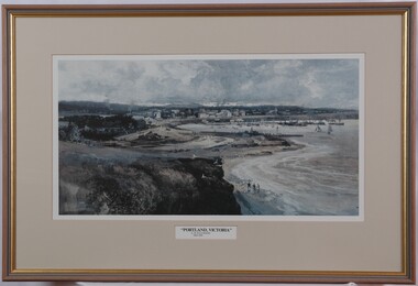
Print, Albert Henry Fullwood, Portland Victoria, c. 1886
Scene of Portland Harbour. View includes people walking on beaches, jetties, morred boats (some with sails, some without). Upper centre of image shows a town, with a church to the right. To the left centre is a planned garden with people promenading. In foreground is empty land with a few seagulls. A train track enters the image on bottom centre. Print is predominantly in shades of blue, grey and brown. Framed, no glass.Front: A. H. Fullwood Back: (no insciptions)print, portland harbour -
Glenelg Shire Council Cultural Collection
Map - Map - Map of the Town of Portland in the Colony of Victoria, 1853
Displayed in History House.Map of a harbour and town, bordered with detailed drawings of building of the town and two index keys to sites in the town.Back: (no inscriptions) -
Glenelg Shire Council Cultural Collection
Administrative record - Programme, n.d
-
 Greensborough Historical Society
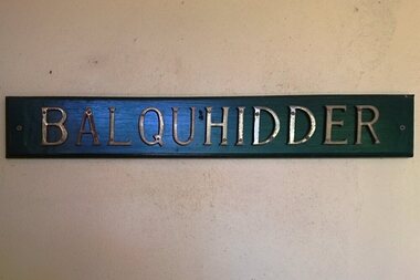
Photograph - Digital image, Marilyn Smith, Scotland House: House name - Balquhidder, 03/12/2016
Formerly the home of Greensborough pioneer, John Scotland, this renovated home retains many original architectural elements. It was sold in December 2016. The house name is Balquhidder, named after a small town in Scotland which was the home of Rob Roy MacGregor.Digital copy of colour photographjohn scotland, scotland avenue greensborough, balquhidder -
 Glenelg Shire Council Cultural Collection
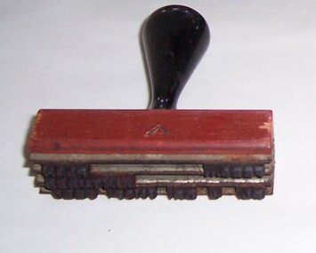
Functional object - Wooden Stamp, n.d
Portland Town CouncilWooden handle, rubber stamps, metal framestamp, administration, portland town council -
Glenelg Shire Council Cultural Collection
Plan - Plan - early Portland, n.d
Early plan drawing of PortlandHand-drawn plan on paper, glued on linen backing. Plan shows layout of properties and a lagoon. Hand-tinted in colour. Names of property owners written on lots.plan, map, town, portland -
 Glenelg Shire Council Cultural Collection
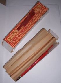
Functional object - Box of sealing wax, n.d
Possibly from the Portland Town Council collection.Artefacts relating to the Portland Town Council represent the history of the Glenelg Shire and how it came to be. The Glenelg Shire Council was established by an Order-in-Council under the Local Government Act 1989, published in the Victorian Government Gazette S63 on 23 September 1994. Three councils were amalgamated, the City of Portland and the Shires of Glenelg and Heywood, to form the new Glenelg Shire.Cardboard box containing 11 full sticks and 5 partial sticks of sealing wax. Sealing wax embossed with maker detailsFront: Orange and yellow paper label on top. S. Maw, Son and Sons Fine sealing wax Crest in centre with London Englandportland town council, local government, glenelg shire, administration -
 Glenelg Shire Council Cultural Collection
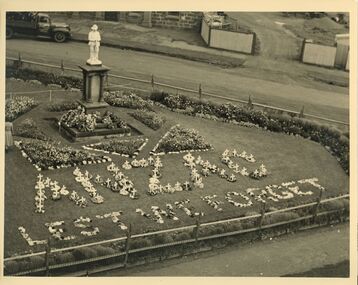
Photograph - Photograph - Anzac Memorial, n.d
Con Kroker CollectionBlack & white photo. Part of the Memorial Triangle floral display for Anzac Day. The words "ANZAC & LEST WE FORGET" are formed with flowers arranged on the lawn in front of them memorial. Old Town Hall in background. -
 Glenelg Shire Council Cultural Collection
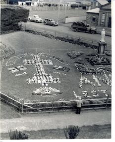
Photograph - Photograph - Anzac Memorial, n.d
Con Kroker CollectionBlack & white photo, part of the floral display at the Memorial Triangle, for Anzac Day. This photo is taken from an elevated position. A cross union jack with 1914-18 underneath, Australian Flag with 1939--45 underneath & rising sun emblem, formed from flowers arranged on the lawn. Memorial on right. Old Town Hall & Portland Bowling Club at rear. -
Glenelg Shire Council Cultural Collection
Certificate - Certificate - Historic Buildings, Portland Town Hall, 1974
... Glenelg Shire Council Cultural Collection History House ...From the Victorian Heritage Register: The foundation stone of the original Portland Town Hall was laid by William Learmonth on 21st September, 1863 following a competition and subsequent public controversy over the permitted entry of architect John Barrow. The conservative classical design of municipal surveyor Alexander Ross was preferred and this axially planned design with central council chamber and side offices fronted by a fine axed pedimented gable entablature of basalt and Tuscan Doric pilasters was completed by 24th may 1864. The old Town Hall is one of a distinguished group of public buildings in Portland and an interesting example of conservative classical architecture of the first years of settlement in western Victoria. The basalt structure was partially erected of stone from the Portland stockade and has significant historical associations with local Government administration in the district. The Town Hall is the most impressive work of Alexander Ross, a surveyor architect whose career remains largely undocumented. The old Town Hall at Portland has been discreetly extended at the rear to provide additional meeting room accommodation. The premises are no longer used for local government administration.A4 sized certificate demonstrating Portland Town Hall's special significance to the state of Victoria & inclusion on the Historic Building Register. Singed by Robert Maclellan, Minister for planning & Historic Buildings Council Chairperson. Red seal attached, bottom right.portland town hall, history house, heritage register, historic buildings, certificate -
Glenelg Shire Council Cultural Collection
Functional object - Sticker, PORTLAND 150th, n.d
Portland celebrated the 150th anniversary of its formation as a town in 1984. A number of commemorative items were produced.Oblong-shaped promotional sticker, promoting Portland's 150th celebrations in 1984. Black text printed on white background, plus logo of whale in triangle with blue green wave designs.Front: Portland's 150th Anniversary 1934-1984 Victoria's First Permanent Settlement150th, 1984, 1934, sticker, commemorative, celebration -
Glenelg Shire Council Cultural Collection
Functional object - Hole Punch, n.d
Heavy duty metal 'Velos' hole punch used at Glenelg Shire Council ( and most likely former Town /City Council) Metric, so most likely made after early 1970'sFront: Heavy Duty Velos Trade Mark Perforator Made in England NO 4376 Back: RP. 102/10 -
 Glenelg Shire Council Cultural Collection
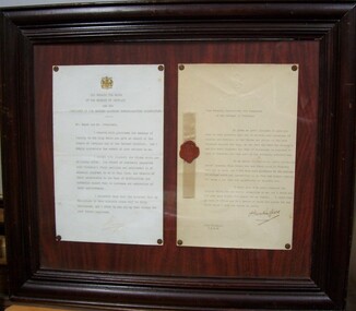
Letter - letter - Letter from Governor of Victoria to His Worship, The Mayor, Borough of Portland, 1934
On display in frame with 1391.2 in History House. Portland Centenary Celebrations. Portland Town Council.Letter with gold crest top centre. Addressed to His Worship the Major. Framed -
 Glenelg Shire Council Cultural Collection
Letter - Letter - Letter from Governor of Victoria to His Worship, The Mayor, Borough of Portland, 1934
On display in frame with 1391.1 in History House Portland Centenary Celebrations Portland Town CouncilLetter with gold crest top centre. Addressed to His Worship the Mayor. -
 Glenelg Shire Council Cultural Collection
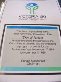
Certificate - Sesquicentenary Certificate, 1985
Displayed at History House. Portland's Sesquicentenary. Portland City Council.Certificate with "Victoria 150" logo at top. In a black-boxed square in lower two-thirds of paper is certificate endorsing the activities of the Town of Portland's planning committee for events of Anniversary Year November 17, 1984 - November 11, 1985.Front: Signature of Ranald Macdonald, Chairman (lower centre, faded pen). -
 Glenelg Shire Council Cultural Collection
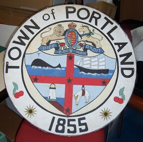
Memorabilia - Town of Portland - Float Decoration, Town of Portland: Float Decoration, n.d
Displayed in History House.Round board with print of town coat of arms affixed. Measures in diameter 71.2cm x Depth of 0.6cm -
 Glenelg Shire Council Cultural Collection
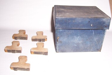
Functional object - Box and Stamps, 1960-1970
Portland Town Council?Blue cloth-covered box hinged lid, with numerous ink stains inside. (3784.1) Contains eleven stamps - wooden partially-varnished handles, rubber stamp glued to base are ink depiction of stamp on top. (3784.2 - 3784.12) Stamps: "1/2", "P", "1", ".", "?", ",". "£" "_", "_". -
 Glenelg Shire Council Cultural Collection
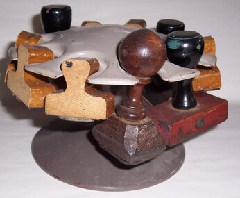
Functional object - Stamp Holder, n.d
Portland Town CouncilMetal stamp holder with turning top.council stationery, portland archives -
Glenelg Shire Council Cultural Collection
Ceremonial object - Commemorative Trowel, 1863
Laid foundation stone of Portland Town Hall 1863Silver engraved trowel in velvet-lined case. Presented by the Municipal Council of Portland to William Learmonth esq. The chairman on the occasion of his laying of the foundation stone of the council chamber 21st Sept. 1863