Showing 1423 items matching "allotment"
-
 8th/13th Victorian Mounted Rifles Regimental Collection
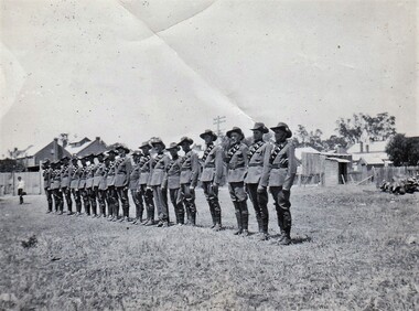
Photograph - 20 Light Horse group
The 20th Light Horse (Victorian Mounted Rifles) was raised in 1920 as part of the 3rd Cavalry Brigade, 2nd Cavalry Division, Citizen Military Forces, with Headquarters at Seymour and depots along the Goulburn Valley from Mansfield to Tocumwal in southern NSW. In December 1941, 20th Light Horse (Victorian Mounted Rifles) converted from horse to mechanised, initially as 20th Motor Regiment. In 1943 the Regiment was deployed to Merauke, Dutch New Guinea. Upon its return in April 1945, the Regiment was redesignated 20th Pioneer Battalion. It was disbanded following the end of the war. 20th Light Horse was the only light horse regiment to serve overseas in WWII.This is one of a collection of photographs featuring a Light Horse regiment drawn from rural and regional Victoria in the period immediately prior to mobilisation for World War 2 (1939-1945).Black and white photograph of single line of soldiers fallen-in in a vacant allotment surrounded by houses and fences. Part of 20th Light Horse collection.20lh, uniform -
 Ringwood and District Historical Society
Document, Plan of Subdivision - Part of Crown Portion 5, Parish of Ringwood, County of Bourke - (Undated)
Map showing layout of 4 numbered allotments coloured red and land coloured blue appropriated or set aside for drainage and sewerage puposes.Map includes Nelson Street and Ringwood Street, Ringwood, Vic. -
 Ringwood and District Historical Society
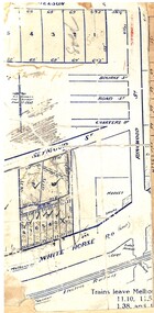
Map, Partially trimmed copy of a retail and residential auction advertisement, Ringwood, Vic. - 1926
One of 3 unrelated land subdivision maps on cardboard backing. Numbered allotments on Nelson Street, Seymour Street and Whitehorse Road, Ringwood.W.J. Bonwick, Licensed Surveyor, Phone WU4830. Location map also includes Bourke Street, Bond Street, Charter Street, Ringwood Street, and Shops and Market sites in Ringwood. -
 Linton and District Historical Society Inc
Certificate of Title, Certificate of Title : Crown Allotments 27, 28, 29, 30, Section 4, Township of Linton
The land was transferred to Theophilus William Nelson and James Adolphus Nelson in 1929. James and Theo Nelson later (1955) acquired Allotment 36, Section 4 which adjoins these allotmentsCopy of Certificate of Title for several adjacent blocks of land on the corner of Clyde Street and Grantley Street in Linton. Copy is comprised of photostat sheets held together by tape.theophilus william nelson, james adolphus nelson, certificates of title, allotments 27 - 30 township of linton -
 Bendigo Historical Society Inc.
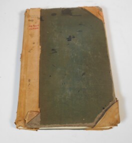
Administrative record - Land sales applications
Green cover book with brown leather spine. The book lists the applications for allotments of land for sale. The headings in the book are: number of application, date of registry, date of application, surname, Christian name and address, parish, allotment, section, area, local land board, Licence dated, licence issued, references and remarks. The book covers the years 1908-1960.On the cover in black ink "Castlemaine" and in red ink "138 front, 130 Rear" On the first page in pen: 138-129 front 130-121 back.land sales, castlemaine -
 Warrnambool and District Historical Society Inc.
Documents Maps (3) - Warrnambool Town Allotments, City of W'bool Parish of Wangoom Country of Villiers, 1948
These maps were produced in 1948 and they contain maps of allotments within the city of Warrnambool, including the Central Business District, up to 1948. The details given on each allotment show the allotment and section numbers, the measurement in acres, the name of the original purchaser of the lot and the date of the first sale. The Warrnambool and District Historical Society owns several copies of these maps but these ones are originals.These three maps are of great significance because they give the names of land purchasers in Warrnambool from the date of the first land sales in 1847. They are a most valuable research tool and can be scanned and photocopied etc.These are three sheets of cream paper pasted on to linen. The sheets have black and white printing and map work. Some of the edges are a little frayed and there is some staining, particularly on the backs of the sheets.‘City of Warrnambool Parish of Wangoom County of Villiers Sheet 1’ ‘City of Warrnambool Parish of Wangoom County of Villiers Sheet 2’ ‘City of Warrnambool Parish of Wangoom County of Villiers Sheet 3’city of warrnambool, warrnambool maps, warrnambool town allotments 1948, land purchases -
 Ringwood and District Historical Society
Flyer, Land Sale Advertisement - Sunbeam Estate, East Ringwood, Victoria - circa 1930
Folded double-sided page advertising private sale of 48 residential allotments, with location map, terms of sale, and details of local features and services. Locality plan includes Holland Road, Everard Road, Sunbeam Avenue, Mount Dandenong Road, and Lilydale Road (later Old Lilydale Road). (Agents) Phillips & Nicholson, 59 Swanston Street, Melbourne, (Phone) Central 10907, in conjunction with C.E. Carter, Bank Chambers, Main Street, Ringwood, Telephone Ringwood 24. -
 Ringwood and District Historical Society
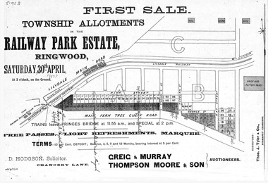
Flyer, Subdivision advertisement - Railway Park Estate, Ringwood, Victoria - circa 1887
Photocopy of advertisement for auction sale of township allotments in Railway Park Estate, Ringwood, on Saturday 30th April (1887?), with terms of sale and location map.Subdivision map includes Pitt Street and Main Ferntree Gully Road (later Bedford Road). (Agents) Greig & Murray, Thompson Moore & Son, Auctioneers. -
 Ringwood and District Historical Society
Map - Plan of Subdivision, Part of Crown Portions 32 & 33, Parish of Warrandyte, County of Evelyn - 1951
Map attached to light cardboard backing showing size and location of 4 residential allotments on Mullum Mullum Road Ringwood, east of Warrandyte Road.Owner - G.H.F. MacMullen 36a Mullum Road, Ringwood - 23 August 1951. -
 Warrnambool and District Historical Society Inc.
Documents, Swintons Paper att 18/53 Merri St. Contract. Map. Notes, 1959
These documents relate to the sale of land in Merri Street Warrnambool in 1959 by Swintons Pty Ltd of Warrnambool. The buyer of the land was George O’Grady, a Warrnambool baker. The land sold for £4000 and there was a shed on the land (called the ‘Office’) which George O’Grady indicated he wished to be included in the sale. William and Ann Swinton migrated to Australia in 1854 and for a decade William Swinton worked as a builder and carpenter in the Warrnambool area, erecting many buildings, including the Wangoom Presbyterian Church. In 1865 he opened a store in Timor Street Warrnambool, selling groceries, hardware, china and glassware. By 1888 the business was known as William Swinton and Sons. Branch stores were opened in Wangoom, Cudgee, Nullawarre, South Warrnambool and West Warrnambool. After William Swinton died his son Robert became the first managing director of Swintons Pty Ltd. In 1934 the business split with George Swinton and Sons selling clothing, furnishings and glassware and Swintons Pty Ltd selling seeds, produce and hardware. Today the Swinton family still operates a furniture and bedding shop in Timor St Warrnambool.These items are of some interest as being connected to the Warrnambool business of Swintons Pty Ltd. They will be of interest to researchers. The current Swinton business in Timor Street is the oldest family business in Warrnambool and, with the name Swinton associated with businesses in Timor Street Warrnambool for 152 years it is amongst the oldest family businesses in Australia.The items here relate to the sale of land by Swintons Pty Ltd., Warrnambool. .1 These are three pages of white paper with typed material, a lawyer’s signature in blue ink, one green stamp and a sketch of the land location. .2 This is a sheet of thick paper containing a plan of the land sold. The paper has printed material and a sketch of the land with part of it coloured in pink. .3 This is a small piece of paper torn at the bottom right edge. It has handwritten material (a letter) in blue ink..2 ‘Plan of Survey of Part of Crown Allotment 18 Section 3 Township of .2 ‘Plan of Survey of Part of Crown Allotment 18 Section 3 Township of Warrnambool Parish of Wangoom County of Villiers’ .3 ‘Tuesday Dear Mr Swinton I am writing to say that I would like to have the ‘Office’ Thanking You George O’Grady’swinton family,, warrnambool -
 Eltham District Historical Society Inc
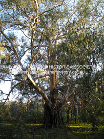
Photograph, Fay Bridge, Yellow Box Gum tree near junction of Main Yarra Trail and Mullum-Mullum Trail, Templestowe, 7 July 2019
Situated in the wetlands on the trail opposite the Pontville Homestead, former home of Major Charles Newman and across the Yarra River from Sweeneys Flats, Eltham. Newman also purchased Allotment 5, Section 2 (in Ely Street, Eltham) at public autction on 17 September 1851. It was the only Section 2 allotment purchased at the firts Elthan Town Allotments public auction.fay bridge collection, sweeneys flats, 2019-07-07, major charles newman, mullum mullum creek, pontville homestead, significant tree, yellow box gum (eucalyptus melliodora) -
 The Beechworth Burke Museum Research Collection
Card (Series) - Index Card, George Tibbits, William Street, Beechworth, 1976
George Tibbits, University of Melbourne. Faculty of Architecture, Building and Town & Regional PlanningIndex system that support the research for Beechworth : historical reconstruction / [by] George Tibbits ... [et al]Arranged by street names of BeechworthEach index card includes: street name and number of property, image of property, allotment and section number, property owners and dates of ownership, description of the property according to rate records, property floor plan with dimensions.beechworth, george tibbitsbeechworth, george tibbits -
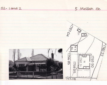 The Beechworth Burke Museum Research Collection
Card (Series) - Index Card, George Tibbits, 5 Mellish Street, Beechworth, 1976
George Tibbits, University of Melbourne. Faculty of Architecture, Building and Town & Regional PlanningIndex system that support the research for Beechworth : historical reconstruction / [by] George Tibbits ... [et al]Arranged by street names of BeechworthEach index card includes: street name and number of property, image of property, allotment and section number, property owners and dates of ownership, description of the property according to rate records, property floor plan with dimensions.beechworth, george tibbitsbeechworth, george tibbits -
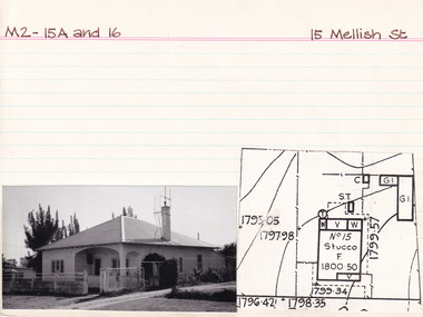 The Beechworth Burke Museum Research Collection
Card (Series) - Index Card, George Tibbits, 15 Mellish Street, Beechworth, 1976
George Tibbits, University of Melbourne. Faculty of Architecture, Building and Town & Regional PlanningIndex system that support the research for Beechworth : historical reconstruction / [by] George Tibbits ... [et al]Arranged by street names of BeechworthEach index card includes: street name and number of property, image of property, allotment and section number, property owners and dates of ownership, description of the property according to rate records, property floor plan with dimensions.beechworth, george tibbitsbeechworth, george tibbits -
![Monnington [Estate], 1935](/media/collectors/550653872162f11fb04854aa/items/5907eb86d0ce0c14e82385c8/item-media/5907ecafd0ce0c14e823e87f/item-fit-380x285.jpg) Kew Historical Society Inc
Kew Historical Society IncPlan - Subdivision Plan, Monnington [Estate], 1935, 1935
Pru Sanderson, in her groundbreaking ‘City of Kew Urban Conservation Study : Volume 2 - Development History’ (1988), summarised the periods of urban development and subdivisions of land in Kew. The periods that she identified included 1845-1880, 1880-1893, 1893-1921, 1921-1933, 1933-1943, and Post-War Development. These periods were selected as they represented periods of rapid growth or decline in urban development. An obvious starting point for Sanderson’s groupings involved population growth and the associated economic cycles. These cycles also highlighted urban expansion onto land that was predominantly rural, although in other cases it represented the decline and breakup of large estates. A number of the plans in the Kew Historical Society’s collection can also be found in other collections, such as those of the State Library of Victoria and the Boroondara Library Service. A number are however unique to the collection.Subdivision plans are historically important documents used as evidence of the growth of suburbs in Australia. They frequently provide information about when the land was sold on which a built structure was subsequently constructed as well as evidence relating to surveyors and real estate and financial agents. The numerous subdivision plans in the Kew Historical Society's collection represent working documents, ranging from the initial sketches made in planning a subdivision to printed plans on which auctioneers or agents listed the prices for which individual lots were sold. In a number of cases, the reverse of a subdivision plan in the collection includes a photograph of a house that was also for sale by the agent. These photographs provide significant heritage information relating house design and decoration, fencing and household gardens.The first subdivision of Monnington took place in 1935. At that time, Monnington and 10 new allotments were offered for sale bordering Adeney and Marshall Avenues. In this subdivision plan, Monnington is one of 13 lots for sale. The subdivision created the irregular land holding of Monnington today. The excision of southwest corner of Monninton was caused by the need to have regular allotments facing the curve in Marshall Avenue.monnington - adeney avenue -- kew (vic.), subdivision plans -- kew (vic.) -
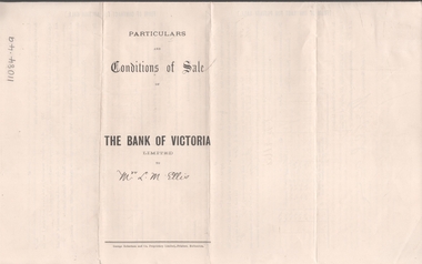 Bendigo Historical Society Inc.
Legal record - ELLIS Edward Woodrow Tregenza - Land sale records, Watson, James & Rogers, Rogers Collection, 1907
In the early 1980s the firm of Watson, James & Rogers merged with the partnership of Every & Every and became the iconic “Rogers & Every” as known today. The firm is still located on Bull Street. https://rogersevery.com.au/about/* Particulars, conditions of sale and contract from bank of Victoria to Louisa Mary Ellis. 1907. * Plan of subdivision of crown allotments 20, 22, 23 Parish of Sandhurst, County of Bendigo * Agreement between Rupert Noyes Putnam of Williamson St. Bendigo and Edward Woodrow Tregenza Ellis of High St Bendigo for Crown allotments 18 and 19, Parish of Sandhurst County of bendigo.Signaturesrupert noyes putnam, land sales -
 Greensborough Historical Society
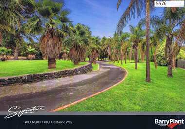
Advertising leaflet, 3 Marino Way Greensborough, 30/11/2012
3 Marino Way Greensborough, 6 bedroom 2 storey home on 4215 sq m allotment, auctioned on 30 November 2012, sold for $1,580,000. Property has since been subdivided into 7 allotments4 page colour real estate advertising leafletmarino way greensborough -
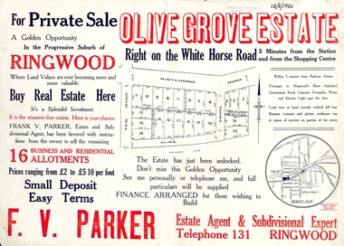 Ringwood and District Historical Society
Flyer, Land Sale Advertisement, Olive Grove Estate, Ringwood, Vic. - 1926
Further development of 9 shop sites took place along Whitehorse Road (later street numbers 58 to 64 Whitehorse Road) between New Street and Olive Grove around 1950 - See Victorian Collections reference 5227.Single sided page with red and blue print advertising Olive Grove Estate business and residential allotments, including subdivision plan and summary of local services.Subdivision includes Whitehorse Road, New Street, and Olive Grove. Agent - F.V. Parker, Telephone 131, Ringwood. -
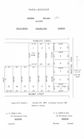
 Ringwood and District Historical Society
Plan, Ringwood Station Estate, Subdivision, Ringwood, Victoria - circa 1925
ID 5224 note: Further information relating to squares marked H, F, G, J, and K included in ID 5225 - Ringwood Shop and Dwelling Estate.Hand drawn plan of Ringwood Station Estate showing allotments for sale, with two typed pages attached showing land title information and sale prices.Drawn by Edyth Greenwood, phone 988 Central. Subdivision includes Station Street, Pitt Street, Bedford Road, Wantirna Road, James Street, William Street (later Kendall Street), Greenwood Avenue, Ellison Street, and Haig Street. Circles denote blocks for sale. Squares denote house properties for sale. Other features marked include location of businesses along Main Street (Maroondah Highway), cool store, railway station, shop and police station on Bedford Road, church on Station Street, site of schoolmaster's residence and State School, and location of proposed public baths. Ryner & Langford, Solicitors -
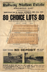 Ringwood and District Historical Society
Flyer, Subdivisional Auction Sale Brochure, Railway Station Estate, Ringwood East, Vic. - 1918
Advertisement for subdivisional auction sale of 80 residential allotments on Saturday, 21st December, 1918, including terms of sale, subdivision layout, and nearby location photographs.Subdivision includes Mount Dandenong Road (incorrectly shown as White Horse Road), Dublin Road, Freeman Street, Bona Street, and Patterson Street. Local Agent - J.B. McAlpin, Telephone Ringwood 7. -
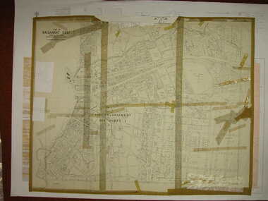 Federation University Historical Collection
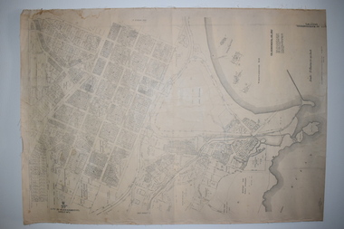
Plan, Ballarat East, 1916, 24/05/1916
Plan of streets and allotments in Ballarat East. Includes: Bakery Hill, Canadian Station, Eureka Cemetery, Orphan Asylum, Eureka Gardens and Reserve, Gun Clubballarat east, bakery hill, eureka stockade site, eureka gardens, ballarat orphanage -
Port Melbourne Historical & Preservation Society
Document - Notice, Land auction, Williamstown Road to Plummer Street, Port Melbourne, R Holden Stone, Borough Surveyor Brighton and Port Melbourne, Mar 1887
Large auction notice advertising sale of land Williamstown Road to Plummer Street 19.3.1887, with general (distorted) plan of Port Melborne and a larger plan of the allotmentstown planning, fishermans bend, land sales -
Bendigo Historical Society Inc.
Map - SUTTON GRANGE, 10th July 1872
Map: Residence sites at Sutton Grange, being subdivision of Allotment 10 Sec. 3, Parish of Sutton Grange (number 275 in map cupboard 1)map, subdivision, sutton grange, residence sites, allotment 10 sec. 3 -
Clunes Museum
Document - DOCUMENT - COVENANT, PRIMITIVE METHODIST CHAPEL
LAND TO BUILD PRIMITIVE METHODIST CHAPEL ONCOVENANT BETWEEN TALBOT LAND BUILDING INVESTMENT SOCIETY AND THE PRIMITIVE METHODIST CHAPEL IN CLUNES DATED 29/05/1877 FOR ALLOTMENT 12 SECTION 6.primitive methodist chapel, talbot land building and investment society -
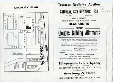 Whitehorse Historical Society Inc.
Document, The Avenue, 1950
Brochure for auction of 9 allotments bounded by The Avenue, Laurel Grove and Laburnum Street, Blackburn on 18 November 1950Brochure for auction of 9 allotments bounded by The Avenue, Laurel Grove and Laburnum Street, Blackburn on 18 November 1950. Ellingworth's Estate Agency and Armstrong & Hoath.Brochure for auction of 9 allotments bounded by The Avenue, Laurel Grove and Laburnum Street, Blackburn on 18 November 1950auctions, the avenue, blackburn, laurel grove, laburnum street -
 Kew Historical Society Inc
Plan, Studley Heights Estate, 1936
Pru Sanderson, in her groundbreaking ‘City of Kew Urban Conservation Study : Volume 2 - Development History’ (1988), summarised the periods of urban development and subdivisions of land in Kew. The periods that she identified included 1845-1880, 1880-1893, 1893-1921, 1921-1933, 1933-1943, and Post-War Development. These periods were selected as they represented periods of rapid growth or decline in urban development. An obvious starting point for Sanderson’s groupings involved population growth and the associated economic cycles. These cycles also highlighted urban expansion onto land that was predominantly rural, although in other cases it represented the decline and breakup of large estates. A number of the plans in the Kew Historical Society’s collection can also be found in other collections, such as those of the State Library of Victoria and the Boroondara Library Service. A number are however unique to the collection.Subdivision plans are historically important documents used as evidence of the growth of suburbs in Australia. They frequently provide information about when the land was sold on which a built structure was subsequently constructed as well as evidence relating to surveyors and real estate and financial agents. The numerous subdivision plans in the Kew Historical Society's collection represent working documents, ranging from the initial sketches made in planning a subdivision to printed plans on which auctioneers or agents listed the prices for which individual lots were sold. In a number of cases, the reverse of a subdivision plan in the collection includes a photograph of a house that was also for sale by the agent. These photographs provide significant heritage information relating house design and decoration, fencing and household gardens.The ‘Studley Heights Estate’ on the South Side of Studley Park Road was launched in 1936. The seventeen allotments in the subdivision fronted Hyton Crescent and Studley Park Road.subdivision plans - kew, studley heights estate -
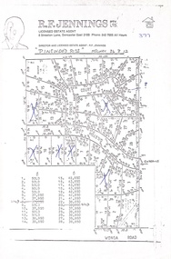 Ringwood and District Historical Society
Document, Land Sale Map and Price List - Pinewood Rise Subdivision, Ringwood, Victoria - (Undated, circa 1988)
Single page black & white photocopy of subdivision plan showing layout of 28 residential allotments with inset showing price list & some marked 'sold'.Director and Licensed Estate Agent - R.F. Jennings Pty Ltd., 8 Streeton Lane, Doncaster East 3109. Phone 842 7666 all hours. -
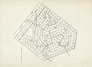 Ringwood and District Historical Society
Map, Plan of Subdivision - Mullum Mullum Road, Ringwood - Circa 1969
Photocopy of subdivision - 128 residential allotments in Mullum Mullum Road, Sonia Street, Linda Drive, Jill Court, Eve Court, and Alma Court, Ringwood. -
 Ringwood and District Historical Society
Document, Auction Flyer - Hill's Estate, Wantirna Road, Ringwood - 1960
Typewritten details of Land Auction, 14th May, 1960, with map showing ten allotments in area bounded by Yarmouth Street, Wantirna Road and Walmer Street. Terms £100 Deposit. Residue £30 qrt including interest 6-1/2% Balance 5 years. (Agents) - A.T. Miles & Son, 175 Whitehorse Road, Ringwood WU.6215. C.E. Carter & Son, 126 Whitehorse Road, Ringwood WU.6024, WU.6830. -
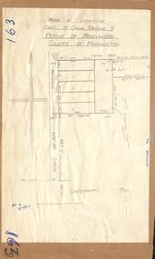 Ringwood and District Historical Society
Map - Plan of Subdivision, Part of Crown Portion 7, Parish of Ringwood, County of Mornington - circa 1950
Hand-drawn map attached to light cardboard backing showing 5 residential allotments on eastern side of Maidstone Street Ringwood, north of Canterbury Road.RFK 8/11/51