Showing 17196 items matching "bay-bridge"
-
 Phillip Island and District Historical Society Inc.
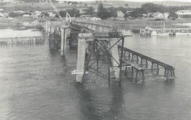
Photograph, Phillip Island Bridge, 1968/9
1969 2nd Phillip Island Bridge under construction. Suspension Bridge demolished early 1970 From the Jack Jenner CollectionConcrete stanchions and scaffolding of new Bridge part built.(opened 1969). Taken from other half looking towards San Remo.local history, photographs, civil engineering, bridges, phillip island bridges, black & white photograph, jack jenner collection, public construction -
 Eltham District Historical Society Inc
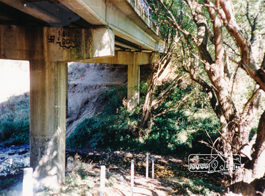
Photograph, Doug Orford, Bridge Street Bridge, Eltham
Two colour photographs of Bridge Street Bridge over Diamond Creek, Eltham showing bridge sub-structurebridges, diamond creek, eltham, bridge street -
 Eltham District Historical Society Inc
Photograph, Doug Orford, Bridge Street Bridge, Eltham
Two colour photographs of Bridge Street Bridge over Diamond Creek, Eltham showing bridge sub-structurebridges, diamond creek, eltham, bridge street -
 Kew Historical Society Inc
Postcard, Victoria Street Bridge, Collingwood, 1905-1913
Victoria Bridge is a riveted and welded steel Warren truss bridge over the Yarra River completed in 1884 to a design by Fraser & Chase following a controversial design competition held in 1880. Funds for the bridge's construction were provided by the councils of Collingwood, Hawthorn, Kew and Richmond. The contract was awarded to Mr P. Platt. Charles Rowand was officially appointed Supervising Engineer in 1883. The winning design was based on the theoretical work of William Charles Kernot (1845-1909) who campaigned for economy in public works design and the application of scientific principles in engineering. ... The bridge was widened in 1890 by the addition of a third line of truss on new piers on the up stream side to carry horse trams. Work commenced in 1914 to convert the horse tramway to an electric tramway by the Prahran & Malvern Tramways Trust, part of the Trust's extension of its tramway into the eastern suburbs between 1913-18. In 1915 the bridge was further strengthened to accommodate the extra weight of electric trams and widened by the addition of two six feet cantilever footpaths. During this period the Prahran & Malvern Tramways Trust erected two ornamental gantries over the roadway to support overhead wires for the electric tramway. Further widening and reconditioning of the bridge took place in 1933, including the addition of four new welded trusses, two intermediate and two on the outside. The latter were supported on new cantilevered truss cross beams attached to the top of the piers. (Source: Heritage Victoria)Early and rare postcard of the Victoria Street Bridge linking Victoria Street and Barkers Road.Polychrome postcard of the Victoria Street Bridge which links Richmond and Abbotsford with Kew and Hawthorn.View from Harrison Cres embankment / former Xavier College boatshed on site of tree in foreground. / Chimney left corner - Wool Scoring Mils in Victoria St. / On horizon - Studley Villa, Studley House circa 1880s, Studley Hall / Chinese gardens to be seen behind three set of columns / M.J. Slatterypostcards -- yarra river, postcards -- bridges. -- greater melbourne (vic.), victoria street bridge -
 Warrnambool and District Historical Society Inc.
Document, Map: Lady Bay 1853, 1853
This is one of the earliest surveys and maps of Warrnambool harbor, Lady Bay. Being done in 1853, it shows the depths of the bay area marked in fathoms, currents and directions and areas of rocks around mouth of the Merri and the Western side of the bay as well as a large sand spit to the middle right of the beach region.. It also marks the large areas of seaweed and fuci in the outer bay area. It has the area of Pertobe Lagoon marked and shows the early tracks to the town. The engraving work was done by Tulloch and Brown, with Tulloch being one of the earliest engravers and lithographers in the state of Victoria. He arrived in Melbourne in 1849 and set up business with James Davie Brown in 1853 with Brown being a map engraver. They were awarded bronze and silver medals for their work at the Victorian Industrial Exhibition. He also worked in the vignettes on the Proeschel Map of Victoria.This map is of high historical and comparitive significance as it shows the Lady Bay area prior to the changes that have occurred in the last 160 years with the building of the breakwater. The issue regarding access to Lady Bay remains a current one. The engraver D Tulloch engraved some of the earliest scenes of the goldfields in Ballarat and as such has left a record of a very early and important era in Australian history. Rectangular cream paper with black text. Map area is outlined by fine black lined border. Key in top right hand corner and scale at bottom middle of map.Map is labelled Town of Warrnambool printed at top of map. Small logo at top right corner which has “Hydrographic Department” in circle around an anchor. Lady Bay Warrnambool Surveyed by John Barrow assistant surveyor Engraved by Tulloch & Brown in bottom right corner. Melbourne engraved by order of the legislative Council of Victoria in middle bottom.map, warrnambool, town of warrnambool map 1853, tulloch & brown map 1853, lady bay warrnambool,, warrnambool harbour, warrnambool breakwater, warrnambool beach -
 Clunes Museum
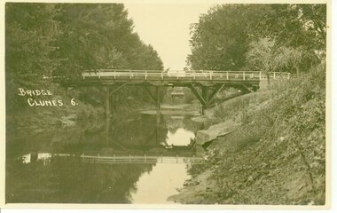
Photograph, D.S. KING
BRIDGE OVER CRESWICK CREEKBRIDGE OVER CREEK "BUTTER FACTORY" BRIDGE AT THE FOOT OF CAMERON ST. CLUNES.BRIDGE. CLUNES 6local history, document, postcard, bridges -
 Victorian Harness Racing Heritage Collection at Lord's Raceway Bendigo
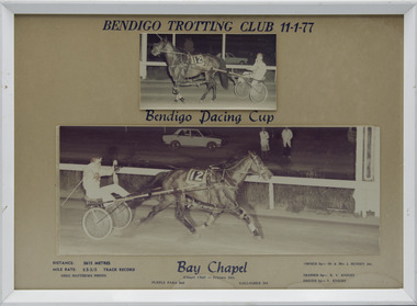
Photograph - Framed photo finish, Greg Matthews Photo, Bay Chapel, 11 January 1977
Bay Chapel won the Bendigo Pacing Cup on the 11 January 1977, followed by Purple Para and Gallagher. Bay Chapel owned by Mr & Mrs J Hussey Jnr, was trained by RV Knight, driven by V Knight. Bay Chapel raced from 1973 (2yo) through to 197 (8yo). Career: 23 wins 14 seconds 17 thirds 132 starts. Refer to Identifier 15.035 (Media) for Full Career Performance Record.Two colour photographs, one small one large in a white frame. At the top: Bendigo Trotting Club 11-1-77/ Bendigo Pacing Cup At the bottom: Left corner: Distance 2615 metres/ Mile rate 2.5.3/5 /Track Record / Greg Matthews Photo Centre: Bay Chapel (Chapel Chief - Princess Del) / Purple Para 2nd / Gallagher 3rd Right corner: Owned by- Mr & Mrs J Hussey Jnr/ Trained by RV Knight/ Driven by - V Knightbendigo harness racing club, horses, race, winner, bendigo trotting club, pacing cup, driver, trainer, owner, 1977, bay chapel, rv knight, mr & mrs j hussey jnr, purple para, gallagher, vj knight, vin knight, bob knight -
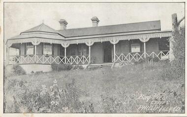 Phillip Island and District Historical Society Inc.
Photograph - Post Card, 17/03/1913
One of 4 photographs donated by Norma Smith. On back of postcard is an order sent to Mrs Smith of Rhyll from Mrs Eva Richardson of Bay View Cowes, for eating apples and pears. Black & White postcard of Bay View Guesthouse."Bay View Cowes, Phillip Island"bay view cowes phillip island, bayview guesthouse cowes, mrs richardson, mrs smith, norma smith -
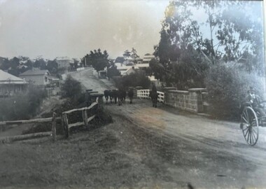 Greensborough Historical Society
Photograph - Photograph (Framed), Herding stock over blue stone bridge looking up Main Street Greensborough
Heading stock over Blue stone bridge looking up Main Street Greensborough. In this photograph, Greensborough was a country town. Note the unmade road leading up to the bridge.From the John Mackey collection. This item was displayed at the offices of Ryan, Mackey and Kelly, solicitors, Main Street Greensborough.Timber-framed photograph of herding stock over blue stone bridge looking up Main Street Greensborough, black and white.greensborough, john mackey, blue stone bridge, marble hall -
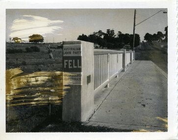 City of Whittlesea
Photograph - Photographs - Bridges, Photograph - Bridge - Bundoora, 1967
Bridge over Darebin Creek, Settlement Road Bundoora. Looking west towards Thomastown, April 1967. Bridge post includes Australian Labor Party election poster for Greensborough Electorate. Bob Fell was the ALP candidate at the 1967 state election which he lost.Photographs, black and white print on paper. Bridge over Darebin Creek, Settlement Road Bundoora 1967. -
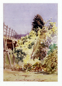 Nillumbik Shire Council
Painting: Walter WITHERS (b.1854 Warwickshire, UK — d.1914 Eltham, Aus), Trestle Bridge, Eltham, c.1903-10
Walter Withers was a significant Australian landscape artist and a member of the Heidelberg School of Australian Impressionists. In 1903 Withers bought 'Southernwood', a house on 2½ acres (1 ha) at Eltham, to which he added a studio. Because of ill health, he lived during the week at his studio in Oxford Chambers, Melbourne, and on weekends and holidays with his family at Eltham until his death in 1914. The Eltham rail bridge is a unique and valuable historic relic of an earlier steam locomotive transport era in the Diamond Creek Valley and has long formed an important part of a magnificent Eltham landscape. When built in 1902 it was close to the terminus point of the Heidelberg-Eltham rail extension, on the route of the proposed Diamond Valley Railway that was then planned to continue much further up the valley towards Kinglake. This bridge is situated in attractive river-valley parkland amidst the tall and spreading manna gums and candlebarks of the Diamond Creek Valley. The Alistair Knox Park river-valley landscape, of which the timber trestle bridge is an important visual component, has been classified by the National Trust. Large manna gum and candlebark trees adorn the adjacent creek banks, and historic Shillinglaw Cottage is also part of this much-prized Eltham landscape. Eltham is home to a historic wooden railway trestle bridge. Mainly of timber-pier and timber-beam construction, but varied by a few longer steel-joists spans on timber piers at the main stream channel, this substantial bridge has almost two hundred metres of timber deck. Built in 1902, it is the only railway bridge of predominantly timber construction that is still in regular use as an integral part of Melbourne's metropolitan electric railway network and one of extremely few timber rail bridges in the State that still carry trains. Apart from its important continuing social function as a carrier of rail transport for the Hurstbridge line, this impressive bridge and its beautiful parkland environs contribute much to the character of Eltham township and that town's special reputation as an historic centre of environmental and conservation concerns. This section of the Diamond Creek Valley was the subject of a Walter Withers painting in the earliest years of the twentieth century and has strong historic links with our Heidelberg School of painters. Watercolour painting on paper of Eltham's Trestle Bridge in the middle of the day. A small section of the wooden bridge is located to the left of the painting. The focus is predominately on the wattle, manna gum and candlebark trees that is to the right of the bridge. The golden hues typically represent the australian sunlight and landscape. "W.W" in gothic script on the lower right side of the painting. Not dated. withers, eltham, trestle bridge, railway, watercolour -
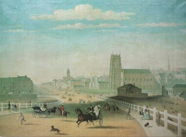 Melbourne Tram Museum
Artwork, other - Swanston Street from Princes Bridge c1861
Colour print of Reproduction of an oil painting - Swanston Street from Princes Bridge c1861 showing Johnson's Bridge Hotel, later Young and Jacksons, the first St Paul's church building, original Town Hall building and the tower of Scots church. Shows pedestrians and horse drawn carriages before the introduction of public omnibus services in 1869. Not known who produced the card.Yields information about early Melbourne after the start of the gold rush.Reproduction of an oil painting - Swanston Street from Princes Bridge c1861 by Henry BurnIn ink on the rear Keith Kings stamp and the initials RG and "Melbourne"melbourne, princes bridge, horse drawn vehicles, st pauls cathedral, hotels -
 Stawell Historical Society Inc
Photograph, Bridge over Wimmera River at Glenorchy
Bridge over Wimmera River at Glenorchy. Church in background on right is the former Presbyterian now United Church. Original photograph taken by Charles Nettleton.Black & white photograph of a timber lined water body with bridge and building in the background. water -
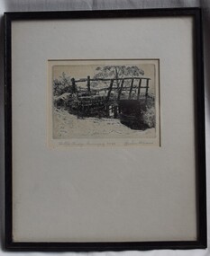 Buninyong Visitor Information Centre
Print - Engraving, The Old Bridge, Buninyong No. 24
The location of the bridge has not yet been identified but further investigations will continue, as will details of when the work was completed by Graham Hopwood.A significant images of an early local structure in Buninyong. Requires further research.Engraving of a rough old timber bridge in Buninyong by artist and art educator, Graham Hopwood.Hand written on the backing paper of the frame: 'Originally owned by JM Matheson, given to Marjorie Matheson, 1956, Olympic Games'.graham hopwood, bridges, engravings, topographical art, buninyong -
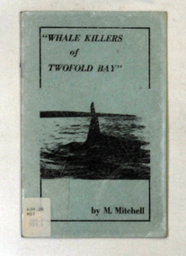 Orbost & District Historical Society
books, Whale Killers of Twofold Bay, circa 1960
Author, Mary Mitchell was the daughter of Charles Wellings early resident of Eden. Charles took many of the early photos of Eden while his brother, Henry, did the research on the Imlay Bros (very early settlers of Orbost) and early Twofold Bay settlers. Mary Wellings married Roy Mitchell of Lower Towamba. In Eden there are streets and a park named for both families.These books record the history of the whaling industry on the south coast of New South Wales.Two copies of a small thin ten page booklet with blue laminated covers. It has black print and a black photo of a whale tail on the front cover.It was written by Mary Mitchell. The book relates the history of whaling at Twofold Bay on the south coast of New South Wales.2116.1 - has a library sticker on the front cove - bottom left hand cornertwofold-bay whaling mitchell-mary welliings -
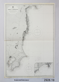 Flagstaff Hill Maritime Museum and Village
Document - Navigation Chart, Tokyo to Sendai Bay
British Admiralty Navigation Chart - Tokyo to Sendai Baywarrnambool, shipwrecked-coast, flagstaff-hill, flagstaff-hill-maritime-museum, maritime-museum, shipwreck-coast, flagstaff-hill-maritime-village, shipwrecked-artefact, british admiralty navigation chart, navigation chart, tokyo to sendai bay -
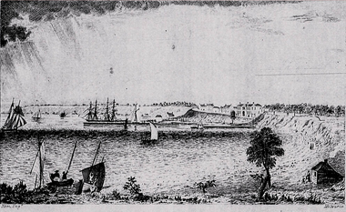 Ballarat Heritage Services
Image, Ham Brothers, Corio Bay, 1850, 1850
Black and white image of the port at Corio Bay in 1850.thomas ham, corio bay, geelong, port, ships -
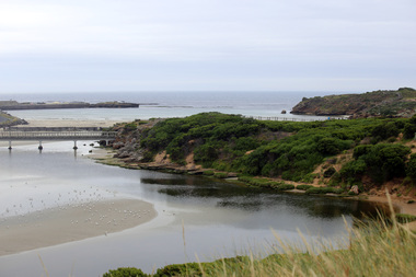 Ballarat Heritage Services
Photograph - Digital photographs, L.J. Gervasoni, Stingray Bay and the Mouth of the Merri River, 2016
Digital image of the mouth of the Merri River at Stingray Bay. landscape, seascape, geology, warrnambool, coast, coastal, stingray bay, merri river, mouth -
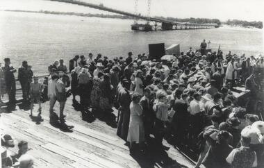 Phillip Island and District Historical Society Inc.
Photograph, Suspension Bridge, 1940
Official opening of Suspension Bridge 1940. Opened by Hon. Albert Dunstan LMHCrowd on work platform. View of new Suspension Bridge at Official Opening. Priest at Lectern at middle right. local history, photographs, civil engineering, bridges, official bridge opening, black & white photograph, jack jenner collection, phillip island bridges, public construction -
 Lakes Entrance Historical Society
Album - Photograph, Judy Davies, Small album of North Arm Bridge Lakes Entrance Victoria, 2000 c
Small album containing fourteen colour photographs of construction of North Arm Bridge and sixteen colour photographs of North Arm Apex Park to Eastern Creek Bay Lakes Entrance Victoriaboats and boating, historic sites -
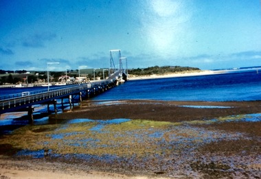 Phillip Island and District Historical Society Inc.
Photograph, First Phillip Island Bridge, Pre 1968
Original Phillip Island bridge which was replaced in 1968Large coloured photo of the first Phillip Island Bridge looking from Newhaven towards San Remo at low tide.Nilnewhaven, phillip island bridge, san remo -
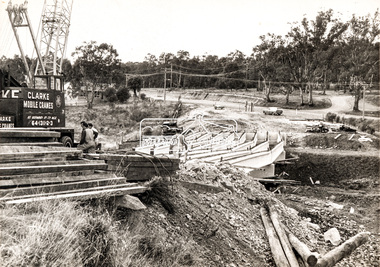 Eltham District Historical Society Inc
Photograph, Construction of new bridge over the Plenty River, Main Road, Lower Plenty, c.Aug. 1966
Construction of the Main Road bridge over the Plenty River. Includes structural members, construction personnel, vehicles and a Clarke mobile crane.Local significanceBlack and white printMarking on back of photograph - Plenty River Bridge Main Road 1969 (sic)lower plenty, main road, plenty river, bridge, bridge construction, civil engineering, cranes, mobile cranes -
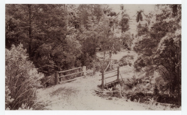 Mt Dandenong & District Historical Society Inc.
Photograph, The Crescent Bridge, Sassafras
Photograph taken at the bottom of the hill on 'The Crescent' at Sassafras where the Crescent Bridge crosses the Sassafras Creek.Black and white cop of a photograph showing a bridge crossing an unmade road over creek. Bush in background.sassafras, sassafras creek, crescent bridge, bridge, the crescent, bush, tree ferns -
 Eltham District Historical Society Inc
Photograph, Peter Pidgeon, North bound traffic routed down Bridge Street during Bolton Street upgrade, Eltham, 13 November, 2017, 13/11/2017
Born Digitalbolton street upgrade, eltham, streets, bridge street -
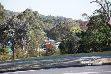 Eltham District Historical Society Inc
Photograph, Peter Pidgeon, The last of the marquees from the Eltham Festival being disassembled viewed from Bridge Street during Bolton Street upgrade, Eltham, 13 November, 2017, 13/11/2017
Born Digitalbolton street upgrade, eltham, streets, bridge street, eltham festival -
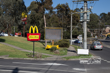 Eltham District Historical Society Inc
Photograph, Peter Pidgeon, McDonalds Restaurant, cnr Bridge Street and Bolton Street, Eltham, during Bolton Street upgrade, 13 November, 2017, 13/11/2017
North bound lane closureBorn Digitalbolton street, bolton street upgrade, eltham, streets, bridge street, mcdonalds restaurant -
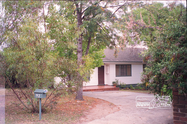
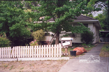 Eltham District Historical Society Inc
Photograph, Margaret Ball, 104 Bridge Street, Eltham, Nov-Dec 1999, 1999
The Margaret Ball (Pre 1960s Houses) Collection was a personal project initiated to mark the year 2000 and arose as a result of the disappearance of many pre-1960s parts of Eltham due to development. Approximately 200 pre-1960s style houses that were left in Eltham between Main Road and east to Bible Street, between Cecil Street to the north and south to Dalton Street were photographed in late 1999. Not all of the houses could be photographed; some because the garden or trees blocked the view of the house, others because of rubbish or cars were in the way, some because people were working on the house or in the gardens at the time.Roll of 35mm colour negative film, 7 stripsKodak GC 400-6eltham, houses, streets, margaret ball (pre 1960s houses) collection, bridge street -
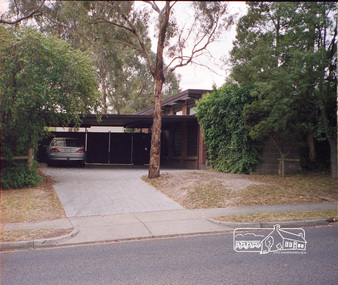
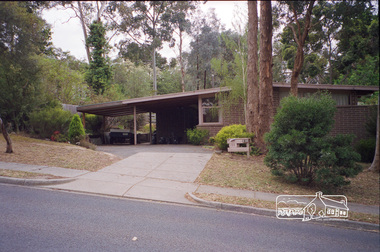 Eltham District Historical Society Inc
Photograph, Margaret Ball, 105 Bridge Street, Eltham, Nov-Dec 1999, 1999
The Margaret Ball (Pre 1960s Houses) Collection was a personal project initiated to mark the year 2000 and arose as a result of the disappearance of many pre-1960s parts of Eltham due to development. Approximately 200 pre-1960s style houses that were left in Eltham between Main Road and east to Bible Street, between Cecil Street to the north and south to Dalton Street were photographed in late 1999. Not all of the houses could be photographed; some because the garden or trees blocked the view of the house, others because of rubbish or cars were in the way, some because people were working on the house or in the gardens at the time.Roll of 35mm colour negative film, 7 stripsKodak GC 400-6eltham, houses, streets, margaret ball (pre 1960s houses) collection, bridge street -
 Eltham District Historical Society Inc
Photograph, Margaret Ball, 92 Bridge Street, Eltham, Nov-Dec 1999, 1999
The Margaret Ball (Pre 1960s Houses) Collection was a personal project initiated to mark the year 2000 and arose as a result of the disappearance of many pre-1960s parts of Eltham due to development. Approximately 200 pre-1960s style houses that were left in Eltham between Main Road and east to Bible Street, between Cecil Street to the north and south to Dalton Street were photographed in late 1999. Not all of the houses could be photographed; some because the garden or trees blocked the view of the house, others because of rubbish or cars were in the way, some because people were working on the house or in the gardens at the time.Roll of 35mm colour negative film, 7 stripsKodak GC 400-6eltham, houses, streets, margaret ball (pre 1960s houses) collection, bridge street -
 Eltham District Historical Society Inc
Photograph, Margaret Ball, 95 Bridge Street, Eltham, Nov-Dec 1999, 1999
The Margaret Ball (Pre 1960s Houses) Collection was a personal project initiated to mark the year 2000 and arose as a result of the disappearance of many pre-1960s parts of Eltham due to development. Approximately 200 pre-1960s style houses that were left in Eltham between Main Road and east to Bible Street, between Cecil Street to the north and south to Dalton Street were photographed in late 1999. Not all of the houses could be photographed; some because the garden or trees blocked the view of the house, others because of rubbish or cars were in the way, some because people were working on the house or in the gardens at the time.Roll of 35mm colour negative film, 7 stripsKodak GC 400-6eltham, houses, streets, margaret ball (pre 1960s houses) collection, bridge street