Showing 402 items
matching boundary street
-
 Myrtleford and District Historical Society
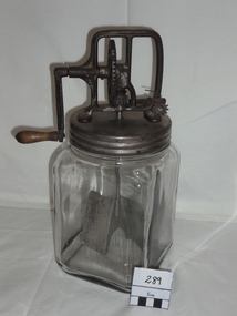
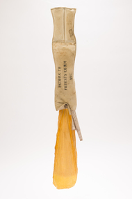
Butter Churn
The churn was used by Elise Weston (nee Trahair) at Barwidgee Creek and Myrtleford in the immediate post-war period. Prior to this time it was in the possession of the Trahair family on their family farm where a small dairy herd met family requirements.The churn represents an aspect of self sufficient living in rural areas outside township boundaries. It assisted households to meet family needs using simple processing technology and more so when surplus butter could be sold on in local markets.An upright clear-glass butter churn with screw-on metal cap, handle and gears. The churn mechanism is fully enclosed. "Daisy" brand with "3Qt" inscribed in the glass.glass butter churn -
 Clunes Museum
Document - NEWSPAPER, THE BALLARAT NEWS, THE NEWS 1/8/1991, 1/8/1991
THE NEWS, 1 AUGUST 1991. REAL ESTATE NEWS, COUNTRY CABIN AT CLUNES. NO. 1 BOUNDARY ROAD ON 4.05 HECTARESreal estate, 1 boundary road -
 Wangaratta RSL Sub Branch
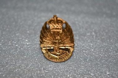
Gold Badge
WW2 War Service Badge issued to former soldiers who had served within the boundaries of Australia and who were, therefore, not eligible for the RAS badge. To be worn on civilian clothing.Gold badge with crown on top, rising sun in middle, an anchor at the bottom.On front: Service at bottom of crown. Australia is written at bottom, under anchor. On back: 1948, Issued by C'Wealth Govt, Amor Sydney. 49241australia, wwii, world war 2 -
Tatura Irrigation & Wartime Camps Museum
Print - Heaphy's Whim - Inn Framed Print, Heaphy's Whim Inn
The inn was located on the SW corner of the intersection now known as Dhurringile Rd and Hogan St. There is now no trace of the pictured building. This was the northern boundary of the James Winter estate and was called " Nelson Gate ". The town "whim " ( water pump ) was near the Brown St / Albert St round-a -boutBlack and white print in a black plastic frame with white card surround. Inn with horses and carts, people in the carts, people standing under verandah and off to the side. Wide section of road in front and trees behind -
Tatura Irrigation & Wartime Camps Museum
Drawing - Sketch, Tatura Camp 1
Herman Bernhard SCHMIDT was a foundry owner in Queensland. He was interned and sent to Gaythorne internment camp for 6 months and then sent to Tatura Camp 1 until 1946 when he was released.Black and white sketch Camp 1 Tatura showing boundary of camp and location of huts. Framed in a dark coloured wood and under glass. Has a light plum coloured mount.label on back "Donated by the Gunther Schmidt Family Trust" (son of Herman Bernhard Schmidt - Tatura WW2) March 2023herman bernhard schmidt, queensland foundry owner, camp 1 tatura, gunther schmidt trust, gaythorne camp queensland -
Tatura Irrigation & Wartime Camps Museum
Sculpture - Sandstone Maps of Australia, 1940
2x hand carved sandstone maps of Australia with space for penny in one & metal kangaroo in other. 1. Space for penny in centre. Markings for state boundaries. Creamy coloured stone. 2. Metal (copper?) kangaroo in centre. Pink tinged stone.1. Tatura 1940 2. 1940 Taturatatura;, handcrafts, carving -
 Tatura Irrigation & Wartime Camps Museum
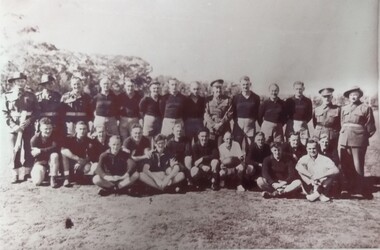
Photograph, 1946
Might be Bill Baker (extreme right). Could be the Tatura side.Black and white photograph of the footy team 18 plus the boundary umpire holding the Sherrin, laces out. 7 standing, 1 row of 6 kneeling and 1 row of 6 sitting. camp 13, camp football games, bill baker -
 Tatura Irrigation & Wartime Camps Museum
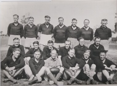
Photograph, Garrison football Team 1944, 1945
Group photograph of the garrison football team in 1944.Black and white photograph of 14 standing, 5 in uniform, 10 kneeling, including the umpire holding ball, 4 seated cross legged including the boundary umpire.camp 13, internment camp football fields -
Tatura Irrigation & Wartime Camps Museum
Document, Geological Plan, Eildon Dam Site, 1945
To record details of geological aspects of EildonA series of maps illustrating rock formations etc., locations, boundaries and planswater/irrigation, documents, maps -
 Tatura Irrigation & Wartime Camps Museum
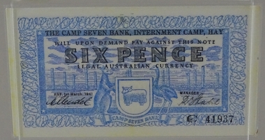
Currency - Bank note, 1st March 1941
Designed by Dunera internee, Teltscher, and printed by Riverine grazier at Hay internment campFacsmilie. Encapsulated/laminated bank note to the value of six pence, with blue colour design(s) on white background with black printing. Features emblem of kangaroo, emu and merino ram above banner of the words "Camp seven bank". Display in plastic stand frameC41937, Printed on back of bank note "This note is valid only within the boundaries of Camp 7 Internment Camp Hay" "The bank is under no obligation to honour this note if presented by holder outside the Camp".tatura, numismatics, notes -
 Tatura Irrigation & Wartime Camps Museum
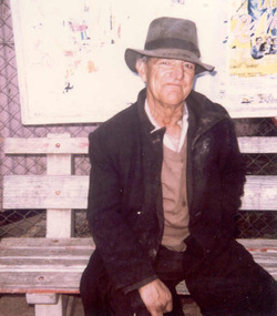
Photograph, Harry Murray, 2001
Harry Murray, a keen Tatura Football Club follower, supported his team by running around the boundary for the whole match.murray, harry, football supporter, photograph, people -
 Victorian Aboriginal Corporation for Languages
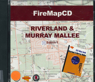
CD-ROM, Country Fire Services South Australia, FireMapCD Riverland &? Murray Mallee, 2001
The area covered by this map is the same as the CFS Riverland & Murray Mallee Map Book. The area covered adjoins the Mount Lofty Ranges map book on the eastern boundary at Murray Bridge, north to Morgan and east to Renmark and the State Border. It extends southwards to join the northern boundary of the Lower South East map book at Padthaway.CD-ROMfire protection, victorian maps -
Victorian Aboriginal Corporation for Languages
Book, C C Culvenor, The boundaries of the Mount Franklin Aboriginal Reserve, 1992
"This enquiry into the boundaries of the Mount Franklin Aboriginal Reserve had its origins in the preparation of a biography of geologist Thomas Smith of Sandon, which raised queries about Boundary Gully Road, Parkers Gully and the location in that vicinity of the Reserve boundary. At a subsequent meeting of the Daylesford Historical Society, commemorating the 150th anniversary of the founding of the Aboriginal Reserve at Franklinford in 1841, it became clear that the actual boundaries were only poorly known ... A search for information srouces in Melbourne and Sydney did not produce an overall Plan, but it is hoped that the material obtained will present a sufficiently accurate picture to be useful to other local historians and be of some interest also to the general reader" --Preface. Contents: The boundaries of the Mt. Franklin Aboriginal Reserve The five mile radius The Tarrengower challenge Provisional boundaries Survey of the Reserve Breakup of the Reserve References Appendices.maps, b&w illustrations, b&w photographsmount franklin -
 Victorian Aboriginal Corporation for Languages
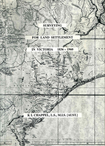
Book, K L Chappel, Surveying for land settlement in Victoria 1836-1960 : survey of the Vic-NSW boundary, survey of the Vic-SA boundary, 1996
A record of the early history of surveying for land settlement. Includes appendices on the border surveys between Victoria and South Australia and between Victoria and New South Wales.maps, b&w photographs, illustrationssurveying, land settlement -
 Victorian Aboriginal Corporation for Languages
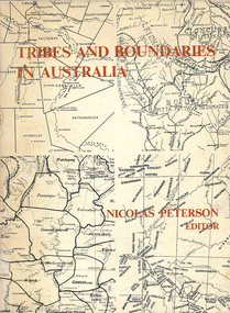
Book, Nicolas Peterson, Tribes and boundaries in Australia, 1976
Some ecological bases for Australian tribal boundaries /? Norman B. Tindale Man and ecology in the highlands of southeastern Australia : a case study /? Josephine Flood The natural and cultural areas of Aboriginal Australia : a preliminary analysis of population groupings with adaptive significance /? Nicolas Peterson 'The chain of connection' : the material evidence /? D.J. Mulvaney Realities and transformations : the tribes of the Western Desert of Australia /? Joseph B. Birdsell Structure, event and ecology in Aboriginal Australia : a comparative viewpoint /? Aram A. Yengoyan Territoriality and the problem of demarcating sociocultural space /? Ronald M. Berndt Communication and change in mythology /? Kenneth Maddock Levels of organisation and communication in Aboriginal Australia /? D.H. Turner Boundaries and kinship systems in Aboriginal Australia /? F.G.G. Rose Tribes, languages and other boundaries in northeast Queensland /? R.M.W. Dixon Aboriginal language distribution in the Northern Territory /? E.P. Milliken.maps, b&w photographs, diagramsecology, environment, sociology, kinship systems, language distribution -
 Victorian Aboriginal Corporation for Languages
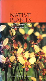
Book, David Jones et al, Native plants of Melbourne and adjoining areas : a field guide, 1999
A simple guide to the Indigenous plants of the Melbourne region. The extent of the boundaries of this region is outlined in the introduction.Colour photographs, glossarynative plants, melbourne, identification -
 Victorian Aboriginal Corporation for Languages
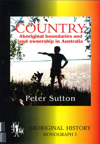
Book, Peter Sutton, Country : Aboriginal boundaries and land ownership in Australia, 1995
Critique of Davis and Prescott Aboriginal frontiers and boundaries in Australia and map, Davis, S. Australias extant and imputed traditional Aboriginal territories; uses anthropological and linguistic evidence to expose inaccuracies and lacunae in book and map; appended are comments on the Davis map by regional specialists.Maps, colour photographsindigenous land boundaries -
 Hume City Civic Collection
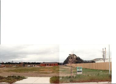
Photograph, early 1990s
The series of 5 photographs feature different views of the Woodlands housing development which opened up land bounded by Gap and Anderson Roads, Cornish Street and Elizabeth Drive in the early 1990s. It was a large housing development built close to Sunbury township.A view of the northern boundary of the Woodlands housing development in Anderson Road. A paling fence divides the estate from the 'Malley' factory, now 'Storage King' which is on the corner of Cornish Street and Anderson Road. A 'For Sale' sign is in the foreground and a partly built house is in the middle distance.housing developments, anderson road, george evans collection -
 Forests Commission Retired Personnel Association (FCRPA)
Drop Chute
From the early 1960s, the Forests Commission had pre-season arrangements in place with local aeroclubs and pilots across regional Victoria. Air observers from FCV districts routinely flew during the summer months in small, fixed-wing aircraft on fire spotting missions and to map fire boundaries. The information was often needed quickly by crews on the ground or in the control centre and these small chutes were used to drop messages and maps from the reconnaissance aircraft on a low pass above a cleared area like a football field. About 3-foot long when fully extended, they had a small pouch secured with a press stud for the map or package. The chutes were made from tough canvas with a small, weighted sandbag at one end and a long yellow streamer tail on the other to help direct its fall and locating it on the ground. Drop chutes were still in common use in the 1990s, but the increased availability of helicopters combined with improved digital data transfer made drop chutes redundant. Simple, but now redundant technologyAerial drop chute"Return to Forests Comm Vic" stenciled on sidebushfire -
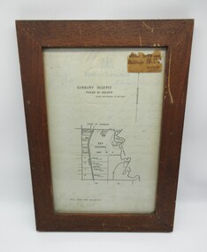 Hume City Civic Collection
Plans, SUNBURY RESERVE PARISH OF HOLDEN
This object is a plan of a proposed recreation ground at Munro's. This was unfenced land between Evans and Barkly Streets adjacent to the Asylum boundary, now Jacksons Hill.A wooden framed plan of a proposed recreation ground.sunbury, sunbury asylum, george evans collection -
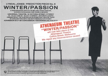 Melbourne Athenaeum Archives
Flyer, Poster & newspaper article, Prediction Piece 8: Winter/Passion Lyndal Jones performed at the Athenaeum 2 commencing 15th July 1986
Transferred from original performance location in Fitzroy to Melbourne Athenaeum Theatre. The Elizabethan Trust production was performed after a season at the Sydney Biennale. The performance consisted of five, 20-minute variations on a fictional love story. The theatre review by Leonard Radic comments: This kind of performance theatre is an attempt to cross the boundaries between art and theatre. It is genuinely experimental in that it seeks to give new meaning to old situations. ... It dares to be different.Large flyer, 2 small flyers and newspaper articleprediction piece 8: winter/passion, lyndal jones, athenaeum theatre, the australian elizabethan trust, program -
Clunes Museum
Map, 1962
.1 &.2 MAP OF BALLARAT SHIRE GROUP RURAL FIRE BRIGADES FIRE CONTROL MAP. COMPILED BY C. H. FENTON. (2 COPIES) DETAILING SEALED ROADS, STATE FORESTS, PINE PLANTATIONS, FOREST AREAS, RAILWAYS, BOUNDARIES, TOWNSHIP AREAS CEMETERIES, CREEKS, SWAMPS AND HOUSES.local history, document, maps, fire brigade -
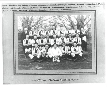 Clunes Museum
Photograph - PHOTOGRAPH FOOTBALL CLUB 1930, HORNBY PHOTOGRAPHER BALLARAT. (COPIES IAN PYMM), 1930
PHOTOGRAPH KEPT AT CLUNES FOOTBALL CLUBPHOTOGRAPH OF CLUNES FOOTBALL CLUB 1930 - MOUNTED ON GREY CARD WITH DARK GREY BORDER .1 ORIGINAL PHOTOGRAPH MOUNTED .2 MOUNTED PHOTOGRAPH WITH NAMES AND 'CLUNES FOOTBALL CLUN 1930' .3 PHOTOCOPY OF .2.2 LIST OF NAMES : BACK: BRIT JONES, (PRES).L EXELBY, L THOMAS,M ROGERS, M MITCHELL, R MCKENZIE, N SPARK, A CLARKE, MINTY ROBERTS, (TRAINER), CENTRE: M O'DONNELL, R DUNN, R ADAM, L CARTER (V.C)., D WRIGHT( CAPT), G LEISHMAN, G DUNN, J LEISHMAN. FRONT: S DUNN, H PETTIT, J PASCOE(BOUNDARY), E BROWN, G RICKARD.photographs, football, football club 1930 -
 Nillumbik Shire Council
Public Art: Helen BODYCOMB (b.1964, South Australia) and Enver CAMDAL (Lives and works Turkey), Enver Camdal et al, Nest (Location: Roundabout, Main and Luck Street, Eltham), 1997
Commissioned by Nillumbik Shire Council - 1997 The selection panel in the commissioning process to this 'extraordinary acquisition' was Rhonda Noble, Director of La Trobe University Museum of Art, Jeph Neale, Eltham Roundabout Advisory Group, Chris Marks, NSC Curator of Collections, Geoff Glynn, NSC Manager of Infrastructure Development.'Nest' highlights the indigenous flora and fauna of the Shire. The stiff, coarse grass used to create the nest is indigenous to the area and the eggs are like those of the spotted quail thrush, a ground-nesting bird of the Shire. The circular flow or placement of the eggs recalls the revolution of the seasons and nesting cycles. There is a tall light pole above the eggs, shining down at night. The effect is of a giant incubator. Enrichment and nurturing of the larger environment can be associated with this sculpture. This work resembles a large bird's nest, with three egg-like forms of fibreglass covered in a pebble render, set on sand. The nest is positioned within the paved boundary of the roundabout. The nest shape has been created out of stiff, coarse indigenous grass, periodically trimmed so the view is not obstructed. The eggs are a brown-speckled, creamy yellow colour. The three eggs are arranged in a ring, with the narrow end of each pointing to the large end of the next, in a circle that mimics the flow of traffic. N/Apublic art, nest, eggs, eltham, ekphrasis2017, mosaic, pebbles, roundabout, spotted quail thrush -
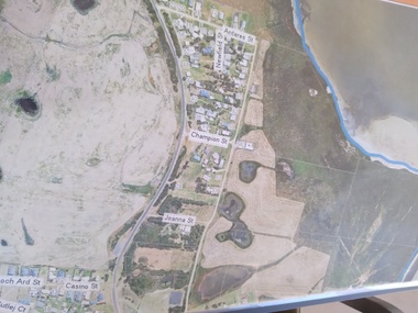 Peterborough History Group
Plan - Moyne Shire Council Aerial photograph, Department of Sustainability and Environment, January 2018
View shows development at the time and showing the town boundary using Vicmap InformationSignificant in that it provides a record of the current state of development of the town. Also, a view of the estuary at that time.A3 size copy of an aerial view of the majority of the town with street names mentioned. curdies river inlet, peterborough, aerial view -
Whitehorse Historical Society Inc.
Pamphlet - Advertising brochure, Kenmare Heights Estate, 1927
Clearing sale by public auction , Saturday 26/11/1927 of Kenmare Heights Estate Mont Albert, Situated between Belmore Road, Boundary Road, Strabane Avenue, Union Road and Dunloe Avenue. Advertising material and mapknight & harwood auctioneer, auctions, kenmare height estate, union road mont albert, belmore road, relowe crescent, whitehorse road, evalina street, francesca street, mozelle street, dunloe avenue -
Whitehorse Historical Society Inc.
Article, School to fight brothel
Blackburn Primary School want City of Nunawading to 'stand up' against the Alfred Street brothel application.Blackburn Primary School want City of Nunawading to 'stand up' against the Alfred Street brothel application. The school strongly supports the principle of the private members bill moved in the Parliament by the Nunawading Province member, Mrs Rosemary Varty. It aims to give Councils the right to veto brothel applications within their boundaries.Blackburn Primary School want City of Nunawading to 'stand up' against the Alfred Street brothel application. brothels, blackburn primary school, no. 2923, city of nunawading, victoria. planning appeals board, varty, rosemary, alfred street, blackburn -
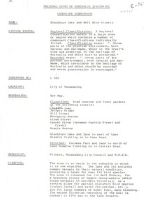 Whitehorse Historical Society Inc.
Document, Landscape Submission, c 1976
... of Australia (Victoria) for Blackburn Lake and the Bell Bird Streets... blackburn jeffery street hill street boongarry avenue linum street ...A landscape submission written for the National Trust of Australia (Victoria) for Blackburn Lake and the Bell Bird Streets.A landscape submission written for the National Trust of Australia (Victoria) for Blackburn Lake and the Bell Bird Streets. Definitions given of boundaries of the Lake area, ownership, housing and gardens. Photographs and map.A landscape submission written for the National Trust of Australia (Victoria) for Blackburn Lake and the Bell Bird Streets.blackburn lake sanctuary, waratah crescent, blackburn, jeffery street, hill street, boongarry avenue, linum street, laurel grove, acacia avenue, city of nunawading, melbourne and metropolitan board of works, furness park, camberwell grammar school -
Whitehorse Historical Society Inc.
Map, VR Box Hill - Blackburn, 1953
Maps of proposed station at Laburnum on Box Hill to Blackburn railway lines, by Victorian Railways, showing boundaries of Victorian Railways land and the proposed boundaries for Laburnum Station.Maps of proposed station at Laburnum on Box Hill to Blackburn railway lines, by Victorian Railways, showing boundaries of Victorian Railways land and the proposed boundaries for Laburnum Station.Maps of proposed station at Laburnum on Box Hill to Blackburn railway lines, by Victorian Railways, showing boundaries of Victorian Railways land and the proposed boundaries for Laburnum Station.laburnum railway station, laburnum street, blackburn, victorian railways -
Whitehorse Historical Society Inc.
Document, Harkaway National School
... State School No 454 Thompson John Edward Street names ...Description and history of Harkaway National School, plus changing of many street names and early pioneers.Description and history of Harkaway National School, plus changing of many street names and early pioneers.Description and history of Harkaway National School, plus changing of many street names and early pioneers.pioneers, harkaway national school, burwood east state school no 454, thompson, john edward, street names, ballyshanassy road, boundary road, delaney's road