Showing 391 items
matching bridges -- river yarra
-
 Marysville & District Historical Society
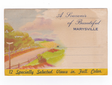
Postcard (item) - Colour photographs, Nucolorvue Productions, A Souvenir of Beautiful Marysville-12 Specially Selected Views in Full Colour, Unknown
An envelope of 12 colour photographs of attractions in and around Marysville in Victoria.An envelope of 12 colour photographs of attractions in and around Marysville in Victoria. These photographs were produced by Nucolorvue Productions in Mentone, Victoria.A Souvenir of Beautiful MARYSVILLE 12 Specially Selected Views in Full Colour Marysville, Victoria, Australia Marysville, 60 miles from Melbourne, is one of nature's/ lovely beauty spots. The invigorating mountain air helps the/ visitor to enjoy the many delightful walks amongst the tall/ timber, or through the fern glades. Apart from many excellent walking trips, Marysville district/ offers ample scope for car trips to the nearby Cumberland Forest,/ Buxton, Narbethong, or the Taggerty Valley. Skiers find Lake Mountain an attraction in the winter, whilst/ the hiker finds ample for his needs in the numerous mountain/ areas. Huge Eucalypt trees, revealing their ramrod straightness up/ to 300 feet in height, are a fitting background to the many/ beautiful creeks and waterfalls. PUBLISHED BY NUCOLORVUE PRODUCTIONS, MENTONE, VICTORIA.nicholl's lookout (image 1), eildon weir (image 2), road to lake mountain (image 3), foot of steavenson falls (image 4), steavenson falls (image 5), bush scene near marysville (image 6), bush track marysville (image 7), bridge and chalet and crossways marysville (image 8), log cabin at marysville (image 9), black spur (image 10), taggerty river (image 11), highest known hardwood tree (image 12), marysville, victoria, nucolorvue productions, postcard, souvenir -
 Marysville & District Historical Society
Ephemera (Item) - Information brochure, Artworkz Tourism, MARYSVILLE-MARYSVILLE ATTRACTIONS, 23-11-2014
An information brochure on various attractions to be visited in an around Marysville. This brochure was produced by Artworkz Tourism in November 2014.An information brochure on various attractions to be visited in an around Marysville.Disclaimer: The authors have taken care to ensure this/ publication is correct, though please be aware that/ errors and omissions do occur.marysville, victoria, australia, information brochure, bruno's sculpture garden, steavenson falls, gallipoli lake, keppel falls, cora lynn falls, phantom falls, taggerty river visitor area, the beeches, meeting of the waters, cambarville day visitor area, the big tree, the big culvert, keppels hut, keppel lookout, mount gordon, marysville golf course, trestle bridge, marysville caravan park, marysville swimming pool, jock's lookout, yellow dog day visitor area, artworkz tourism -
Marysville & District Historical Society
Book (Item) - Ebook, Artworkz Tourism, Marysville Gallery, 05-2012
An ebook on various attractions to be visited in and around Marysville. This ebook was published by Artworkz Tourism in May 2012.An ebook on various attractions to be visited in and around Marysville.cambarville, cambarville waterfalls, cathedral state park, cora lynn falls, historic trestle bridge, jock's lookout, lady talbot drive, keppel falls, keppel hut, keppel lookout, gallipoli park, phantom falls, steavenson falls, taggerty river, taggerty cascades, the beeches rainforest walk, the big culvert, the big tree, meeting of the waters marysville, meeting of the waters buxton, marysville, victoria, australia, ebook -
Marysville & District Historical Society
Document (item) - Report, Clement Wilks, Track to the River Jordan Gold Fields, 1864-1865
A report by Mr Road Engineer Wilks on the construction of the Yarra Track in Victoria.A report by Mr Road Engineer Wilks on the construction of the Yarra Track in Victoria. The Yarra Track is the former name of the gold fields road from Healesville to the Woods Point and Jordan Goldfields, in Victoria, Australia. By Authority: JOHN FERRES, Government Printer, Melbourneclement wilks, yarra track, marysville, victoria, wood's point, healesville, jordan gold fields -
Marysville & District Historical Society
Document (Item) - Document-Table, Judith Vimpani, Yarra Track Hostelries- Marysville to Woods Point, Unknown
A document outlining all the hostelries that existed along the Yarra Track between Marysville and Wood's Point.A document outling all the hostelries that existed along the Yarra Track between Marysville and Wood's Point.yarra track, marysville, wood's point, woods point, fernshaw, paradise plains, black spur, mount grant, george edwards, walker family, melbourne, new chum, hit & miss restaurant, mr clifford, michael woods, glen watts, tri bhean hotel, ewen cameron, ewen hugh cameron, thomas barton, butler's wood's point directory, globe hotel, swanston street, mount juliet, ben more & c, jordan district, jefferson's watts bridge inn, matthew jefferson, reefer's hotel, boyle's hotel, william henry johnson, samuel boyle, black spur hotel, fisher's creek, narbethong, fisher's home hotel, black spur inn, frederick fisher, william hodson, wood's point road, acheron river, acheron bridge hotel, john robson, granton, clifford, wilks creek, wilks creek hotel, patrick maloney, steavenson, marysville hotel, australian hotel, junction hotel, the dutchman's restaurant, henry kuyper, william podlech, mount arnold, mount arnold hotel, charles schultz, james toohey, john gleeson, joy burchall, ian newman, henry brockman, belle isle, belle elle, bellell creek, upper yarra, guerin's bridge, bell's hotel, henry petty, celia moran, ruth petty, cumberland creek, cumberland creek store and restaurant, cumberland creek hotel, charles edwin hargreaves, annie hargreaves, urina hargreaves, alice hargreaves, healesville, josiah hargreaves, henderson drysdale, henry whelan, halfway house, thomas smith, svendson, gosling, donovans creek, chesterville, perry's hotel, john perry, perry's coach and horses hotel, edward courtney, scandinavian hotel, the swede's, walker's hotel, jacob burchart, golden fleece, theodore kappler, george koehler's hotel, david walker, millicent walker, elsie jowett, bill walker, big river, royal mail hotel, shaw's, slingsby davies, edwin jones, elizabeth jane parker, sandridge, archibald charles edwin jones, matlock, alexander myers, frank berwick frederick jones, ned jones, jennie jones, sophie milllicent parker jones, thomas shaw, dorothy walker, travellers rest hotel, reefton, summers, john fehring, f fehring, katerina fehring, john christoph blumeyer, anne fehring, john baker, evelyn observer, anna katrina baker, hannah catherine baker, john frederick baker, mcmahon's creek, oaks, the springs, st clair, sinclair's valley, mountain home hotel, neilson, collins, waters, jan emma sinclair, john sinclair, mr cox, peter sinclair, willie we have missed you hotel, spring vale hotel, robert matthews, thomas crawford -
 Eltham District Historical Society Inc
Negative - Photograph, Russell Yeoman, Para Road / Carter Street Bridge over the Plenty River, Briar Hill, c.Jul. 1969
Bridge over the Plenty River at Briar Hill before widening and alterations. The Plenty River at Briar Hill represented the boundary between the Shire of Eltham and the Shire of Diamond Valley. The bridge was known as the Carter Street Bridge as prior to 1969 Para Road, Briar Hill became Carter Street, Greensborough across the river. It was at this time that the name Para Road was continued and replaced Carter Street.This photo forms part of a collection of photographs gathered by the Shire of Eltham for their centenary project book,"Pioneers and Painters: 100 years of the Shire of Eltham" by Alan Marshall (1971). The collection of over 500 images is held in partnership between Eltham District Historical Society and Yarra Plenty Regional Library (Eltham Library) and is now formally known as the 'The Shire of Eltham Pioneers Photograph Collection.' It is significant in being the first community sourced collection representing the places and people of the Shire's first one hundred years.Digital image 35 mm B&W negativeshire of eltham pioneers photograph collection, briar hill, 1969-07, bridge, carter street bridge, para road, para road bridge, plenty river, shire of diamond valley, shire of eltham -
 Eltham District Historical Society Inc
Negative - Photograph, Carl Walter 1831-1907, Coffer dam in the Yarra River at Anderson's Creek, 1864
... pioneers and painters warrandyte warrandyte bridge yarra river ...1864 photograph of the Coffer Dam in the River Yarra situated (approximately) opposite Whipstick Gully. Remains of bridge built in 1860(?) wrecked by 1863 flood in background. Reproduced page 29 of ‘Pioneers & Painters’ Gold was first discovered in this area at Andersons Creek (Warrandyte) in June 1851 by Louis Michel. Discoveries north of the Yarra did not occur until about 1854. Although it took some months for a true rush to develop it was not long before alluvial workings were being carried on in most of the Shire of Eltham. The last area in which gold was discovered was Kinglake. As the gold became harder to find, deep mining took over from alluvial diggings in the gullies. Perhaps the most extensive of the deep workings was the Diamond Creek Mine just outside the boundary of the Shire. This form of mining was continued into the 1930s. There are believed to be some mines in the area still capable of producing gold but present prices make working these uneconomical. Some gold is still found by weekend prospectors. Photo: Carl Walter 1831-1907 – inscribed on tent “C. Walter Photo” The State Library of Victoria holds over 150 photos by Carl Walter, most of which are portraits of Aboriginal natives including William Barak.This photo forms part of a collection of photographs gathered by the Shire of Eltham for their centenary project book,"Pioneers and Painters: 100 years of the Shire of Eltham" by Alan Marshall (1971). The collection of over 500 images is held in partnership between Eltham District Historical Society and Yarra Plenty Regional Library (Eltham Library) and is now formally known as 'The Shire of Eltham Pioneers Photograph Collection.' It is significant in being the first community sourced collection representing the places and people of the Shire's first one hundred years.Digital image 4 x 5 inch B&W Neg (2) Print 20 x 25 cmshire of eltham pioneers photograph collection, anderson's creek, coffer dam, floods, gold mining, other areas, pioneers and painters, warrandyte, warrandyte bridge, yarra river -
 Eltham District Historical Society Inc
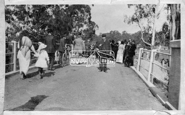
Photograph, Hurstbridge - Cr. Price crossing New Bridge (Opening Day), 1917, 1917
Eltham Shire Councillor Albert Price joined over 500 spectators for the official opening of the new re-inforced concrete bridge across the Diamond Creek at Hurstbridge. Eltham Shire shared the cost of the construction of the bridge with Heidelberg and Whittlesea Shires.This photo forms part of a collection of photographs gathered by the Shire of Eltham for their centenary project book, "Pioneers and Painters: 100 years of the Shire of Eltham" by Alan Marshall (1971). The collection of over 500 images is held in partnership between Eltham District Historical Society and Yarra Plenty Regional Library (Eltham Library) and is now formally known as 'The Shire of Eltham Pioneers Photograph Collection.' It is significant in being the first community sourced collection representing the places and people of the Shire's first one hundred years.Digital imagesepp, shire of eltham pioneers photograph collection, diamond creek, hurstbridge, wattle glen, bridge, councilor price, opening day, diamond creek (river) -
 Eltham District Historical Society Inc
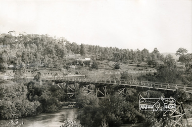
Negative - Photograph, J. P. Lind, Hurst's Bridge, 1885
Looking northwest onto the first bridge at Hurstbridge, 1885. Timber bridge amid rural setting. Two horses graze in an open paddock in the foreground. A house is situated on a rise behind the bridge on a tree lined hill. The area of Hurstbridge was originally known as Hurst’s-bridge after the timber bridge built over the Diamond Creek near Hurst’s station in late 1881/early 1882 on the Hurstbridge-Arthurs Creek Road, Hurstbridge. It was built by John McDonald, of Arthur's Creek and was demolished and replaced in 1917 by a reinforced concrete arch bridge designed by John Monash. Cross Reference Photo No.(s): 1012/1013This photo forms part of a collection of photographs gathered by the Shire of Eltham for their centenary project book, "Pioneers and Painters: 100 years of the Shire of Eltham" by Alan Marshall (1971). The collection of over 500 images is held in partnership between Eltham District Historical Society and Yarra Plenty Regional Library (Eltham Library) and is now formally known as 'The Shire of Eltham Pioneers Photograph Collection.' It is significant in being the first community sourced collection representing the places and people of the Shire's first one hundred years.Digital image 4 x 5 inch B&W Negshire of eltham pioneers photograph collection, hurstbridge, bridge, diamond creek (river), diamond creek (creek), hurst's bridge -
 Eltham District Historical Society Inc
Photograph, Warrandyte Bridge, c.1860, 1860c
... . Bird Timber Merchant Warrandyte Bridge Yarra River Black ...Old timber trestle bridge before it was washed away. Note sign in background for P. Bird Timber Merchant Box Hill. Photo has been damp at some stage and image has stuck to glass causing some damage to image in a number of areas.Black and white photograph mounted in thin black framebox hill, p. bird timber merchant, warrandyte bridge, yarra river -
 Eltham District Historical Society Inc
Photograph, Peter Bassett-Smith, Upper Yarra Dam, Spring Tour, 22 Oct 1995, 22/10/1995
EXPLORING THE UPPER YARRA (Newsletter No. 105, November 1995, by Bettina Woodburn) We enjoyed the Spring Excursion, this year "Exploring the Upper Yarra" - in spite of the constant rain and the countryside under the cloud cover, especially in the valleys, being mainly shiny shades of green. The occasional fields of buttercups, clumps of arum lilies and splendid rhododendron and other flowering bushes became very special. The Cobb and Co coach was warm and a cosy retreat as we zig-zagged on the highways and byways to glimpse the Yarra River, upstream and down, its secret places, and particularly the many bridges. Russell excelled as 'Poet Laureate', reading from Dacre Smyth's book. This 1979 publication includes paintings of all the bridges along the river with poems and brief descriptions of each one. Some of the bridges are in out of the way places and are not very well known. We looked forward to hearing the poetry as much as seeing the ' constructions'…Big Pat (was he short or tall, lean or fat? He did win the two hundred pound reward for discovering gold and had the creek named after him), about the 'Eddies'?, and the disliked 'meccano' bridge in Warburton, etc. etc. The hot roast lunch in the old Reefton Hotel was also most welcome. It was easy to imagine it peopled by miners and early settlers. Starting by crossing the new (1974) concrete bridge at Warrandyte we headed through Wonga Park with views to the Christmas Hills and to the escarpment of the Yering Gorge, which causes flood waters to back up through the Yarra Glen plain, so avoiding disasters downstream. At the end of a long driveway we found the wooden, privately owned Henley Bridge (1935 after the 1934 floods). This facilitates access to different parts of Henley Farm and to Lilydale. Everard Park, named after Blanche Shallard's father, a State Member for 17 years, below the Highway Yarra crossing was in need of care. It is 10 miles from Yarra Glen by road but, as "Yarra Marra” canoeists well know, 32 winding miles down by water. After more delightful countryside scenes we joined the Warburton Highway at Woori Yallock. From the old Railway Station at Launching Place the Centennial Trail for walkers, cyclists and ' horse riders has replaced the rails. The line from Lilydale was opened in 1901, and the last diesel freight train ran to Warburton in 1965. It continued to rain as we had morning tea in Warburton in a shelter between footbridges. From here we continued upstream past the Bridge to O'Shannasy Lodge and Reservoir, Starvation Creek, and the Peninsular tunnel (miners dug it as at Pound Bend) which we visited (scrambling down those steps!) on our return after lunch. Our furthermost point was the Upper Yarra Dam Reserve (and vast catchment area). Finished in 1957 after ten years work and 100 years after Yan Yean, it supplies much of Melbourne's water. After crossing the 30m Launching Place Bridge to the Eltham side of the Yarra and Healesville, we saw in the distance the Yarra Glen Timber Trestle Bridge over the river flats "the longest for years in the land it was said!" Harry's dream of "better weather over the Divide" unfortunately didn't come true, but I'm sure we 36 members will retain happy memories of a day that was wet and green and filled with Bridges. Bettina Woodburn - October 1995 Record of the Society's history of activities - Spring 1995 excursionColour photographactivities, upper yarra dam, 1995, peter bassett-smith -
 Eltham District Historical Society Inc
Photograph, Peter Bassett-Smith, Upper Yarra Dam, Spring Tour, 22 Oct 1995, 22/10/1995
EXPLORING THE UPPER YARRA (Newsletter No. 105, November 1995, by Bettina Woodburn) We enjoyed the Spring Excursion, this year "Exploring the Upper Yarra" - in spite of the constant rain and the countryside under the cloud cover, especially in the valleys, being mainly shiny shades of green. The occasional fields of buttercups, clumps of arum lilies and splendid rhododendron and other flowering bushes became very special. The Cobb and Co coach was warm and a cosy retreat as we zig-zagged on the highways and byways to glimpse the Yarra River, upstream and down, its secret places, and particularly the many bridges. Russell excelled as 'Poet Laureate', reading from Dacre Smyth's book. This 1979 publication includes paintings of all the bridges along the river with poems and brief descriptions of each one. Some of the bridges are in out of the way places and are not very well known. We looked forward to hearing the poetry as much as seeing the ' constructions'…Big Pat (was he short or tall, lean or fat? He did win the two hundred pound reward for discovering gold and had the creek named after him), about the 'Eddies'?, and the disliked 'meccano' bridge in Warburton, etc. etc. The hot roast lunch in the old Reefton Hotel was also most welcome. It was easy to imagine it peopled by miners and early settlers. Starting by crossing the new (1974) concrete bridge at Warrandyte we headed through Wonga Park with views to the Christmas Hills and to the escarpment of the Yering Gorge, which causes flood waters to back up through the Yarra Glen plain, so avoiding disasters downstream. At the end of a long driveway we found the wooden, privately owned Henley Bridge (1935 after the 1934 floods). This facilitates access to different parts of Henley Farm and to Lilydale. Everard Park, named after Blanche Shallard's father, a State Member for 17 years, below the Highway Yarra crossing was in need of care. It is 10 miles from Yarra Glen by road but, as "Yarra Marra” canoeists well know, 32 winding miles down by water. After more delightful countryside scenes we joined the Warburton Highway at Woori Yallock. From the old Railway Station at Launching Place the Centennial Trail for walkers, cyclists and ' horse riders has replaced the rails. The line from Lilydale was opened in 1901, and the last diesel freight train ran to Warburton in 1965. It continued to rain as we had morning tea in Warburton in a shelter between footbridges. From here we continued upstream past the Bridge to O'Shannasy Lodge and Reservoir, Starvation Creek, and the Peninsular tunnel (miners dug it as at Pound Bend) which we visited (scrambling down those steps!) on our return after lunch. Our furthermost point was the Upper Yarra Dam Reserve (and vast catchment area). Finished in 1957 after ten years work and 100 years after Yan Yean, it supplies much of Melbourne's water. After crossing the 30m Launching Place Bridge to the Eltham side of the Yarra and Healesville, we saw in the distance the Yarra Glen Timber Trestle Bridge over the river flats "the longest for years in the land it was said!" Harry's dream of "better weather over the Divide" unfortunately didn't come true, but I'm sure we 36 members will retain happy memories of a day that was wet and green and filled with Bridges. Bettina Woodburn - October 1995 Record of the Society's history of activities - Spring 1995 excursionColour photographactivities, upper yarra dam, 1995 -
 Eltham District Historical Society Inc
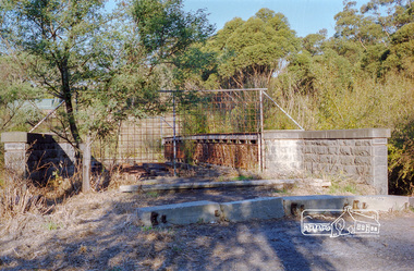
Negative - Photograph, Old Lower Plenty Bridge, 18 Apr 1998
EDHS Autumn excursion to Lower Plenty area The blocked-off iron bridge at Lower Plenty - now re-opened and used as a footway/bike path section joining the Yarra River path.Roll of 35mm colour negative film, 2 strips and associated colour printKodak Gold 200-6activities, lower plenty bridge, autumn excursion, eltham district historical society, lower plenty -
 Eltham District Historical Society Inc
Negative - Photograph, Old Lower Plenty Bridge, 18 April 1998
Plenty River reflections through the old iron Lower Plenty Bridge; Autumn Excursion to Lower Plenty area. The blocked-off iron bridge at Lower Plenty - now re-opened and used as a footway/bike path section joining the Yarra River path.Roll of 35mm colour negative film, 2 strips and associated colour printKodak Gold 200-6activities, lower plenty bridge, autumn excursion, eltham district historical society, lower plenty -
 Eltham District Historical Society Inc
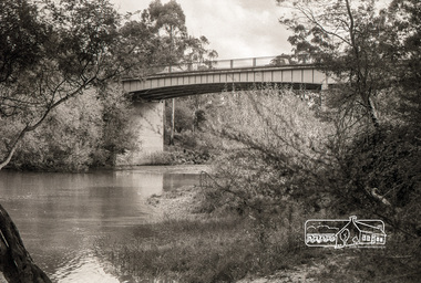
Negative - Photograph, Russell Yeoman, Warrandyte Bridge over Yarra River, c.1970
... Warrandyte Bridge over Yarra River... melbourne Bridge Warrandyte bridges kangaroo ground Road yarra river ...Roll of 35mm black and white negative film, 4 of 7 strips Associated printIlford HP4bridge, warrandyte, bridges, kangaroo ground road, yarra river -
 Eltham District Historical Society Inc
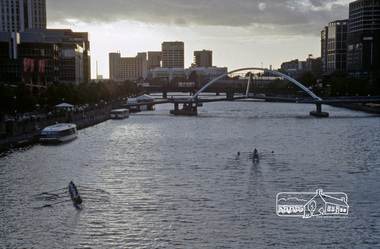
Photograph, Fred Mitchell, Yarra River from Princes Bridge, Melbourne, 1996, 1996
... Yarra River from Princes Bridge, Melbourne, 1996... Digital copy of colour photograph Yarra River from Princes Bridge ...Digital copy of colour photographfred mitchell collection, 1996, melbourne, yarra river -
 Eltham District Historical Society Inc
Photograph, Fred Mitchell, Yarra River from Princes Bridge, Melbourne, 1996, 1996
... Yarra River from Princes Bridge, Melbourne, 1996... Digital copy of colour photograph Yarra River from Princes Bridge ...Digital copy of colour photographfred mitchell collection, 1996, melbourne, yarra river -
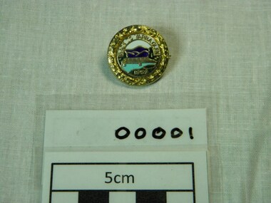 Yarra Glen & District Historical Society
Badges, Stokes, c.1958
The 'Back to Yarra Glen' event was held on the Australia day weekend, 1959. Badge is circular with filigree work around the outer rim. The inner circle has a picture of the Yarra Glen bridge over the light blue river with the dark blue mountains in the background and green river bank in the foreground. There are green trees at each end of the gold bridge. The sky is white. On the green grass foreground is the date 1959. Above the mountains are the words 'Back to Yarra Glen'. The diameter is 2.5 centimetres. It is made of pressed metal, maybe brass, with gold colouring around the outer edge and back. On the front of the badge "Back to Yarra Glen" is across the top and "1959" on the bottom. "Stokes Melb" is on the back -
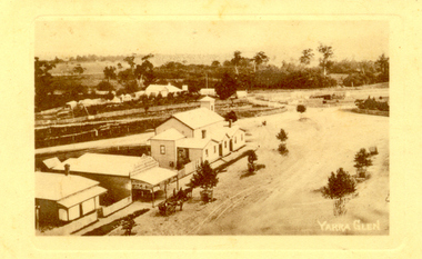 Yarra Glen & District Historical Society
Sepia postcards, Yarra Glen
Sepia postcard with a view taken from the Grand Hotel tower looking down on Bell Street and the railway crossing at Yarra Glen very late 19th century. Young street trees on Bell Street. On east side of Bell Street are a dwelling, a general store, the Victoria Hall, a horse trough. Beyond the railway line is 'River View', the bridge over the river and the Yering flats.On back of postcard at the top "POST CARD". On the left hand side "THIS SPACE MAY BE USED FOR PRINTED OR WRITTEN MATTER”. On the right hand side "ONLY THE ADDRESS TO BE WRITTEN HERE”. In a box in the right hand corner "A HALF-PENNY STAMP TO BE PLACED HERE". Along the left hand margin "Ajax series. Printed in England". In blue biro is written "G. Keets Yarra Glen". Copy 2 has the following handwritten in black ink: "Yarra Glen. 28.8.11. Dear Maggie Hope you will like the Postcard. I also hope your head is better. On Saturday we took the kitten down to Dawborn's shop to catch some mice. When we got down there the kitten got away from us and we never got it till Monday morning. This is all the news this time. From your loving cousin, Walter.yarra glen, railway line, grand hotel, victoria hall, bell street, tree guards, railway crossing, river view, street trees, bell st, general store, horse trough -
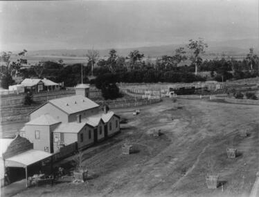 Yarra Glen & District Historical Society
Black and white photographs, Yarra Glen railway crossing c.1900
Black and white photograph in light brown card slip case. The slip case has an image on the front cover of a head and shoulder bust. The photograph was taken about 1900 from the tower of the Grand Hotel looking down upon the Victoria Hall and the railway crossing. In the lower left corner is W.J.Dawborn's General Store. In front of the store is a horse and spring dray and another horse hitched to a veranda post. Next to the store is the Victoria Hall and beyond that a water trough. The railway crossing is in the centre of the picture with two railway cattle trucks next to the cattle yards. Beyond the railway on the left hand side is the property later known as 'River View'. Beyond the river lined with trees are the Yering flats across which can be seen the long trestle railway bridge. In the foreground of the picture is Bell Street lined with trees in wooden tree guards.yarra glen, victoria hall, railway crossing, river view, general store, w j dawborn, horse and cart, horse and dray, spring dray, horse hitched, hitching post, water trough, railway truck, cattle truck, cattle yards, stock yards, yering flats, trestle railway bridge, trestle bridge -
 Federation University Historical Collection
Book, The Old Pioneers' Memorial History of Melbourne From the Discovery of Port Phillip to the World War, 1924
Blue hard covered book of 494 pages. Images, and a large plan of prominent burials in the Melbourne Old Cemetery, and a Map of Melbourne. melbourne, melbourne cemetery, melbourne old cemetery, john batman, edmund hobson, batman's map, st francis' church, james balfour, mrs hornbrook, paddy's market, wilson hall, working men's college, henry kendall, le souef's cottage, world war one, westernport, melbourne cup, hoddle, collingwood, south melbourne, prahran, richmond, kew, brunswick, coburg, preston, hawthorn, camberwell, nunawading, doncaster, st kilda, brighton, sandringham, cheltenham, caulfield, oalkleigh, footscray, sunshine, north melbourne, carlton, ballarat school of art library, ballarat technical art school, book plate, library plate, hume and hovell's overland journey 1824-5, major mtichell's overland journey, australia felix, booplate, aborigine, aboriginal, captain cook, arthur phillip, isaac smith, george bass, matthew flinders, john murray, catain baudain, captain collins, edward henty, portalnd, map od melbourne in 1938, john pascoe fawkner, the "enterprise: and fawkner's first home, old colonists' homes, rushall crescent north fitszroy, richard bourke, the old melbourne post offfice, old governmnt house, toorak, latrobe's house at jolimont, first melbourne land sale, melbourne water supply, peter henry smith, victorian legislative council opening, map of melbourne and collingwood, prince's bridge, crossing the rivers by punt, f.a> rucker, canvas city emerald hill, arrival of the gold escort in melbourne, the yarra, queen's wharf, tall ships, old st james, mary e. budd, st francis church, michael carr, meolbourne city mission, state library of victoria, melbourne public library, bourke street, angus mcmilan, methodist ladies college, ormond college, armistance celebrations, robert russell, mia mia, theatre royal bouke st, melbourne from flaggstaff hill, federal coffee palace collins st, lord melbourne, melbourne mint, old melbourne town hall, robert russell's melbourne and yarra falls, mandevalle hall, point lansdale lighthouse, wilson's promontory, margaret m. ward cole, williamstown, flinders st melbourne, queenscliff battery, broadmeadows soldiers' camp, embarkation of first troops on the 'ceramic', general monsash, ian hamilton, general bridges, victorian war memorial, national war memorial, st kilda pier, first melbourne cup, hoddle's grid, albert park, melbourne mechanic's institute, st kilda toll gate, munted policeman, springthorpe memorial, james bonwick, mornane's paddock, victorian railways melbourne and surburban lines, carlton gardens, thomas napier, wiliam westgarth, george augustus robinson, william lonsdale, elizabeth mary batman, peomena frances darling batman, dig tree, exhibition of 1854, exhibition of 1866, exhibition buildings, geelong harbour, jubilee lake, port campbell, warrnambool, queenscliff lightboat, batman's first house -
Port Melbourne Historical & Preservation Society
Photograph - Yarra River, Ron Laing, 1990s
Part of Ron Laing's collection of photographs recording Port Melbourne over a thirteen year period. Donated to the PMH&PS by the photographer. nb Includes photographs of Victoria Dock in the period of time after the commercial shipping had gone but before the start of the proposed high-rises. The Bolte Bridge which caused this closure of Victoria Dock, North and South Wharves is covered in photos 1319.01-.35.A set of 47 colour photogaphs of the Yarra River at various locations from the old Sandridge Railway Bridge westward to the power house at Newportyarra river, built environment, transport - shipping, ron laing -
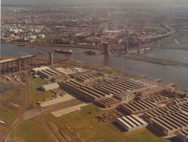 Port Melbourne Historical & Preservation Society
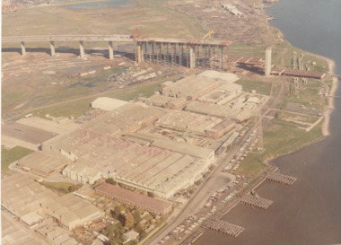
Photograph - Aerial view of West Gate Bridge under construction, 1960 - 1979
... west gate bridge rotten row williamstown yarra river "Master ...Colour aerial photograph of West Gate Bridge under construction. Fishermans Bend factories in foreground. Ship in the river and view to Williamstown"Master copy. Not to be removed from marketing Department" stamped on top right corner and on backtransport, engineering, engineering - bridges, fishermans bend, industry, west gate bridge, rotten row, williamstown, yarra river -
 Port Melbourne Historical & Preservation Society
Photograph - Aerial view of West Gate Bridge under construction, 1960 - 1979
... west gate bridge rotten row williamstown yarra river "Master ...Colour aerial (faded) photograph of West Gate Bridge under construction with two land spans incomplete. "Rotten Row" (disused old piers) in the foreground. Aircraft factory and other industry in foreground."Master Copy . Not to be removed from Marketing department " lightly stamped on photo. and on reartransport, engineering, engineering - bridges, fishermans bend, industry, west gate bridge, rotten row, williamstown, yarra river -
 Port Melbourne Historical & Preservation Society
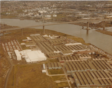
Photograph - Aerial view of West Gate Bridge under construction, 1970 - 1979
... west gate bridge rotten row williamstown yarra river "Gov't A/C ...Colour aerial photograph of West Gate Bridge completed. Aircraft factory and other industry in foreground. Williamstown and fuel storage tanks in background (Coode Island)"Gov't A/C Factories Photographic Section Neg No N2841/3" stamped on backtransport, engineering, engineering - bridges, fishermans bend, industry, west gate bridge, rotten row, williamstown, yarra river -
Port Melbourne Historical & Preservation Society
Photograph - Aerial view of Yarra River and surrounds, 1990s
... piers and wharves - webb dock transport - shipping yarra river ...COPYRIGHT THE AGE Aerial photograph showing the Yarra River, Webb Dock, Port Melbourne beach, Princes pier, West Gate Bridge, Maribyrnong River, Swanston Dock and Melbourne City skyline. Taken mid 1990sStamped "Copyright. This photograph may not be reproduced without permission in writing from the Photo sales department of "the Age"'built environment - commercial, engineering - bridges, fishermans bend, natural environment - beaches and foreshore, piers and wharves - princes pier, piers and wharves - webb dock, transport - shipping, yarra river, west gate bridge, sandridge beach, maribyrnong river, swanston dock -
Port Melbourne Historical & Preservation Society
Photograph - Sandridge railway bridge over Yarra River, Melbourne, Douglas Smallpage, 1970s
... Sandridge railway bridge over Yarra River, Melbourne... in Melbourne Photograph Sandridge railway bridge over Yarra River ...B&W photos of various locations in Port Melbourne Sandridge railway bridge over Yarra in MelbourneSeveral have descriptions of locations in pencil on rear of photostransport - railways, sandridge railway