Showing 1075 items
matching bridges and buildings
-
 City of Ballarat Libraries
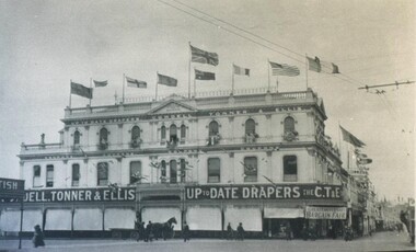
Photograph, Cowdell Tonner & Ellis Drapery Store, Ballarat circa 1916
Located on the corner of Grenville and Bridge Streets, the building has a veranda with sunblind awnings and ornamental trim. A banner on the front says 'Great Anniversary Bargain Fair'. Flags, presumably, of World War 1 allies fly from the roof.building, commerical, cowdell tonner & ellis, grenville street, bridge street -
 Bendigo Historical Society Inc.
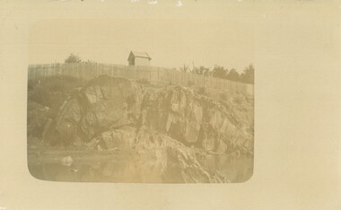
Photograph - POSTCARD - ANTICLINE ON BENDIGO CREEK
Postcard: anticline on Bendigo Creek. Sepia print on postcard. Anticline in centre of photo. Paling fence extends along entire back of photo. Behind fence small weatherboard building (outhouse?) Written on back in pencil ' anticline in creek at Golden Square, area of old bridge over Bgo creek' Stamped in blue ' Bendigo Institute of Technology, Geology Dept. 'place, gold, bendigo, anticline, bendigo creek -
 Bendigo Historical Society Inc.
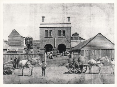
Photograph - WES HARRY COLLECTION: SAYER'S NORFOLK BREWERY, 1860's
... BUILDINGS ...Photograph of a two storied brick building, Norfolk Brewery, Bridge Street, Bendigo. Later taken over by William Bruce and became the BB Brewery. There are two large arched doorways in which there are several workmen and a number of barrels. There are several smaller wooden buildings flanking the main one. There is a dovecote centre left of the photo. Outside the log fence there is a workman holding a horse and cart on which there are several Barrels. On the side of the cart is the painted sign ' Sayer Bros ' and on the left of the gateway can be seen Batchelders photographic cart.Batchelderbuildings, commercial, sayer bros. brewery, sayer bros. brewery, bridge street, dovecot -
 Ballarat Tramway Museum
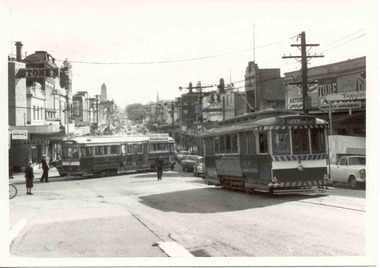
Photograph - Black & White Photograph/s, The Courier Ballarat, 25/04/1966 12:00:00 AM
Yields information about the seemingly frequent derailment of bogie trams at this intersection although this one was an in bound tram. Also details information about the streetscape, and buildings.Black and White copy photograph of a newspaper photograph taken by The Courier - No. 39 derailed, Bridge & Main Sts corner, in bound from Mt. Pleasant. No. 11 awaiting passengers. Photo taken 25/4/1966, published 26/4/1966 Location Stones Corner. Has Bridge St buildings in the background, including Stones signs, Gear Chemist, advertisements for Astor, Turf, Pye, and Suppland. Collected by Alan Bradley from the Ballarat Courier early 1980's. See Excel file "Record of Ballarat Courier Photos SEC era" (Archive Documents) for source of details.On rear stamped "Copyright, The Ballarat Courier Proprietary Limited."tramways, trams, stones corner, bridge st, derailments, accidents, passengers, tram 39 -
 Warrnambool and District Historical Society Inc.
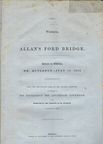
Document, Allan’s Ford Bridge 1852, 1852
This is an original Victorian Government document containing the printed version of 37 reports and letters regarding the building of the first Allansford bridge completed early in 1852. The correspondence dates from October 1850 to February 1852 and includes letters and reports from Melbourne Government employees such as Robert Hoddle, Chief Surveyor, David Lennox, Superintendent of Bridges and Lieutenant – Governor Charles La Trobe. The correspondence from local settlers included the names of William and John Allan, John Davidson and James Coulstock. The correspondence shows that some settlers in the Warrnambool/Port Fairy district wanted a portion of the Government allocated funds spent on the local roads and bridges in other locations. The 1852 Allansford bridge cost £480 and was replaced in 1870. This document has strong historical significance as it relates to one of the earliest State government works in the district and records the public imput into the decision.. It contains opinions and correspondence between a number of early settlers in the district at the time.Grey/blue paper document with black text. 21 pages plus 4 page index at back.allan's ford 1852, allansford bridge, allansford, history of allansford, warrnambool -
 Kiewa Valley Historical Society
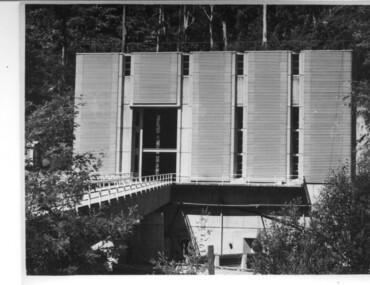
Photograph of Clover Power Station, No. 3 Power Station, after May 1944
In July, 1941 work commenced on the site of the power station with the building of a coffer dam and excavation for the power station building and machine foundations followed. Work proceeded, and the access bridge, transformer foundations and transfer track were completed in April, 1943 and the power station building in May, 1943. Installation of the machines was then proceeded with and No. 1 machine was run for the first time in June 1944. No. 2 machine was completed in April, 1944 and placed in service in May.A pictorial record for the State Electricity Commission of the first Power Station commissioned in the Kiewa Hydro Electric Scheme.Black and white photograph of the bridge and entrance to No. 3 Power Station (Clover Power Station).Handwritten on back of photograph in blue ink "No. 3 Power Station".clover, power station, machine, kiewa scheme -
 Greensborough Historical Society
Photograph, Main Road bridge looking to township of Greensborough, 1929c
View of Main Street Greensborough from Partington's Hill including Plenty River bridge and Marble Hall on corner of Carter Street (now Para Road) and Main Street. This view of Greensborough Park shows the old pan toilets, the hawthorn fence line and the rather undeveloped roadside area of the park. Looking up Main Street we see the old Chapman house at the corner of Poulter Avenue and some newer houses below this. The stone river bridge appears to be only a single lane wide and the road approaching the bridge is unsealed. The rail bridge shows evidence of soot from steam trains and at the extreme left of picture the two concrete buildings indicate the line had been electrified. This occurred in 1923. Sparse housing is seen in the Flintoff Street and Grimshaw Street area.Part of a collection of photographic enlargements of views of Greensborough in the early 1900s.Black and white enlargement of photographic imagemain street greensborough, marble hall, greensborough railway, chapman house, greensborough park, poulter avenue greensborough, carter street, para road -
 Eltham District Historical Society Inc
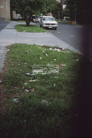
Slide - Photograph, View looking down Luck Street towards Main Road, Eltham, c.Dec. 1987
The former Franklins and McEwans building is on the left. It then became Bunnings before they built a new store in Bridge Street and is presently a Dan Murphy and Aldi store and other smaller stores. The focus for Eltham Shire Council officers in this image is the significant littering concern.35mm colour positive transparency (1 of 7) Mount - Kodak Kodachrome CardProcess Date JUN 86Mroads, infrastructure, litter, luck street, mcewans, franklins, franklins supermarket -
 Ballarat Tramway Museum
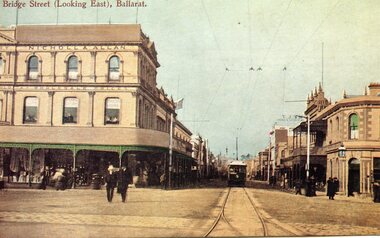
Postcard, John Phillips and Rose Stereograph Co, Bridge St (Looking East), Ballarat, c1905
Image is an ESCo tram leaving the intersection of Grenville St. and Bridge St. and proceeding east along Bridge St. Photo taken behind junction points. Has the Nicholl & Allan building on the left side of the photo and the Bucks Head Hotel on the right. Numerous people walking around the street. Shows overhead construction in the area. Title in top left-hand corner "Bridge St. (Looking East), Ballarat. On the rear is places for stamp, address and manufacturer's name in a fancy motif "WTP". Photo taken soon after opening, no roof-mounted destination boxes. See item 9010 for a printed version. yields information of Bridge St at Grenville St, c1905B&W print, laser print and scanned images of a coloured postcard lent to the BTM by Mr. Norm DePomeroy, August 1998 and Sovereign Hill reproduction of this card contained within a scrap book. See Notes for various image holdings and history.trams, tramways, esco, sturt st, postcards, bridge st., grenville st -
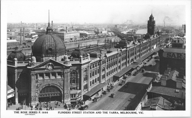 Melbourne Tram Museum
Postcard, Rose Stereograph Co, "Flinders Street Station and the Yarra, Melbourne", late 1920s
... bridges ...Rose Series postcard No. P 1666, titled "Flinders Street Station and the Yarra, Melbourne". This photo is looking southwest from St Paul's Cathedral over the station building along the Yarra river. The St Kilda/Port Melbourne and Queens bridge are in view, but not the Spencer St bridge which was built during the late 1920s. The AW Allen's Limited Confectionary Factory constructed in 1923-24 on Riverside Avenue dominates the landscape on the south side of the river directly behind the dome of the Flinders Street railways station. One very long set of horse-drawn carts can be seen alongside the center entrance to the railway station building in Flinders Street.Yields information about an aerial view of Melbourne late 1920sPostcard - printed real photograph with Rose Stereograph Co. name on the rear.tramways, trams, flinders st station, yarra river, bridges, railways, flinders st -
 Bendigo Historical Society Inc.
Print - ETCHING OF VIEW STREET SANDHURST 1859, 1859
Black and white etching of View Street buildings. Dudley House. Mechanics Institute. Henry Jackson. Pikes bridge with children crossing. Horses & carts. People walking. Timber slats over creek. View street going towards Barnard street. Etching copy of original. View Street. Sandhurst. 1859. Survey & Post Office. FH 566 Not Found 8.12.2022place, bendigo, view street buildings. 1859 -
 Bendigo Historical Society Inc.
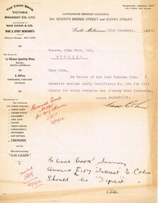
Document - COHN BROTHERS COLLECTION: TYPED LETTER DATED 1922
Typed correspondence from Max Cohn on printed Letterhead paper 'The Cohn Bros Victoria Co Ltd successors to Max Cohn & Co Wine & Spirit Merchants Castlemaine Brewery Buildings, cnr Queens Bridge Street and Hanna Street, South Melbourne dated 22nd December 1922. Estate of the late Roschen Cohn share scrip and transfer. Signed Max Cohn.bendigo, industry, cohn bros brewery, max cohn. roschen cohn. cohn share scrip -
 The Beechworth Burke Museum
Photograph, Unknown c.1930s
This image shows Bethanga Bridge, which was constructed between 1927 and 1930 in Albury, NSW. The bridge was a necessity due to the building of the Hume Dam (Wier), 1919-1936. Bethanga Bridge is a long, nine-span, riveted-steel, variable depth, Pratt Truss road bridge of nine principal spans of 82 metres and a total length of 752 metres over the flooded valley of the Murray River, now part of Hume Reservoir. Because of its unique location, over the waters of a dam with the border running down the centre of the body of water, the Bethanga bridge is the only built structure shared by both New South Wales and Victoria. It was built 1.6 kilometres upstream of the dam and in 1961 was raised 300mm, with a concrete deck replacing the original wooden deck. The State Rivers and Water Supply Commission of Victoria and the New South Wales Department of Public Works were responsible for the construction works for the Hume Weir under the River Murray Waters Agreement. It is apparent that a similar joint arrangement was made for the construction of the Bethanga Bridge as part of the Hume Weir works.This photograph of the Bethanga Bridge is of historical significance as it showcases the architectural skills of Percy Allen and Vincent Packer. Additionally, it reveals the environmental landscape of the 1920s-1930s, is linked to the Hume Dam and both New South Wales and Victorian heritage. Unmounted black and white rectangular photograph. Reverse: 1997.3196 84-20-3bethanga, bethanga bridge, hume dam, pratt truss, murray river, hume weir, transportation -
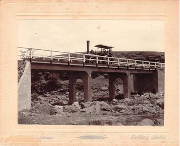 Hume City Civic Collection
Photograph
... bridges ...Chris. Christiansen had a barber shop in Sunbury and was the photographer in the town from 1895 until 1916. He conducted his business in a building situated on the corner of Evans and Brooks Streets. The Gillies Bridge is situated on the Wildwood Road, just off the Lancefield Road.A mounted sepia photograph of the Gillies Bridge at Sunbury. The mounting is cream with silver writing across the bottom of the photograph. There is a man driving a steam roller (traction engine) across the bridge and another man is standing at the bottom of the bridge on the RHS. The creek and rocks are in the foreground. Cream mounting - 2 cm wide with silver inscriptionsChristiansen / Sunbury Studiosgillies bridge, wildwood road, sunbury, bridges, steam rollers, bulldozers, tractors, christiansen, chris, photographers, george evans collection -
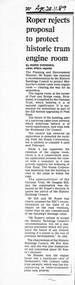 Melbourne Tram Museum
Newspaper - Photocopy, The Age Newspaper, Roper rejects proposal to protect historic tram engine room, 28-11-1989
Provides a report from The Age, 28-11-1989 written by Ingrid Swendsen, about the rejection by the Planning and Environment Minister , Tom Roper to protect the former cable tram winding or Engine house on the corner of Bridge and Punt Roads Richmond, despite the recommendation of the Historic Buildings Council to add it to the register. The building was later demolished by the Roads Corporation to widen the intersection. The Tramways have a small sub-station on the site. Quotes Douglas Hill of the National Trust and Roz Hansen of the Historic Buildings Council. Provides a report on the rejection of a recommendation to protect a historic building.Photocopy of a newspaper clipping from The Age 28-11-1989 - Roper rejects proposal to protect historic tram engine roomtrams, tramways, cable trams, engine house, winding house, punt road, bridge road, demolition, richmond, historic buildings council -
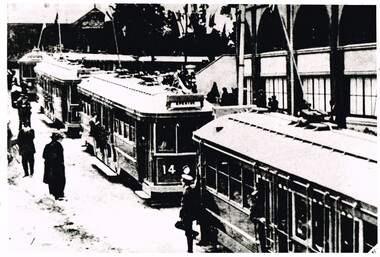
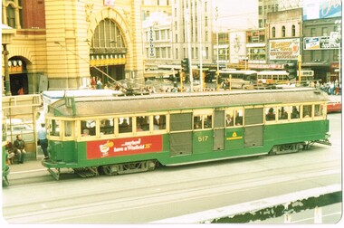 Melbourne Tram Museum
Photograph - Set of 4 Colour Print/s, c1985
Set of four colour prints of trams in Flinders St taken from the Princes Bridge station building deck - 14-5-1985, by an unknown photographer. All printed on Fujicolor Paper with rounded edges. .1 - W2 517 on route 8 northbound in Swanston St with Flinders St station entrance in background. Has a Winfield cigarette advertisement on the side. .2 - W2 453 on route 8, southbound about to cross Princes Bridge with the Anniversary Arch 1984-85 in the background. .3 - W2 605 and W6 994 northbound in Swanston St, with the Flinders St Station concourse buildings in the background. Has a "new black & white 30's" cigarette, Invicta and King Gee work trousers advertisements. .4 - W5 831, south bound on route 72 at the station stop. Has a Reflex copying paper advert on the side panel..3 has in ink on the rear - "W6 994, W2 605 W5 ? Princes Bridge 14.5.85"trams, tramways, flinders st station, princes bridge, swanston st, tram 517, tram 453, tram 994, tram 605, tram 831 -
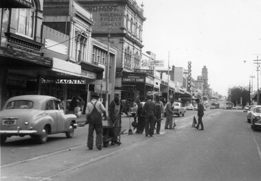 Ballarat Tramway Museum
Photograph - Black & White Photograph/s, The Courier Ballarat, 20/09/1966 12:00:00 AM
Demonstrates nature and size of gang undertaking road repairs during 1966 in Bridge St and the buildings on the south side of the street.Black and White copy photograph of a newspaper photograph taken by The Courier, taken 20/9/1966, published 21/9/1966 of track repairs in Bridge St. Shows the nature of the work, and the level of the traffic in the streets at the time. Eight men working in the view. In the background are the buildings on the south side of Bridge St, including Magnin, a Disposal Variety store, Faull's Foot rest, and Dickins. In the far distance are two trams parked in the loop. Collected by Alan Bradley from the Ballarat Courier early 1980's. See Excel file "Record of Ballarat Courier Photos SEC era" (Archive Documents) for source of details.On rear stamped "Copyright, The Ballarat Courier Proprietary Limited." and "85%" in ink.tramways, trams, bridge st, road works -
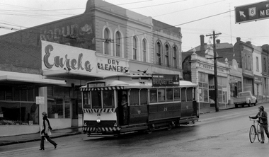 Ballarat Tramway Museum
Photograph - Digital image, 1970s
Yields information about the Bakery St Hill on the Victoria St route.Digital image, black and white, of No. 26 at Stones Corner, junction of Bridge, Victoria and Main St, Bakery Hill. No the young girl in slacks walking in front of the tram, the boy wheeling the bike down the street and the young boy standing in the front door of the tram. In the background is Eureka Dry Cleaners, an old Robur tea ad on a building, F. O'Brien Motors. The tram has the destination of Gardens via Sturt St West and a SEC Briquettes Roof advert. Photo taken by Peter Bruce 1970's and 1971, prior to the closure of the Ballarat tramway system. Peter's Title of image: "No. 26 Victoria and Bridge"trams, tramways, stones corner, bakery hill, victoria st, bridge st, tram 26 -
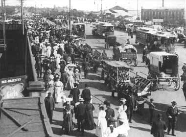 Melbourne Tram Museum
Photograph - Cable trams and stall vendors Princes Bridge, 1908
Black and white photograph of Princes Bridge looking south with produce vendor's carts and many people on both sides of the bridge, generally walking south. In the view are several horse-drawn vehicles, cable trams, one of which is bound for Queensberry St from Toorak. In the view is a poster for Le Girls at Her Majestys Theatre, Worth's Olympic Theatre, and Varley Bros Printer and Bookbinders building. Not known how the photo was dated to 1908. Photo possibly from a postcard.Yields information about Princes Bridge 1908.Black and white print with notes on the rear.In ink "Princes bridge area, crossing over railway lines 1908, City Bound tram - Toorak - Queensberry St route"tramways, tramcars, collins st, victoria bridge, cable trams -
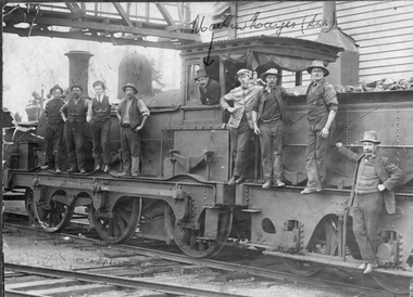 Stawell Historical Society Inc
Photograph, Steam Rail Engine & Workers standing on steam engine. c1900
Steam Rail Engine & 9 workers standing on a Steam Engine. Martin Hayes (Snr.) driver leaning out of cabin. John McInerney left of M. Hayes and below Frank Dunn. The steam engine is under a rail bridge and in the background is a timber building. c1900.Old sepia photo on a damaged mount of 9 railway workers standing on a Steam engine c1900.Martin Hayes (Snr.)stawell railways transport -
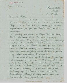 Phillip Island and District Historical Society Inc.
Letter, Letter re Rhyll Presbyterian church controversary over funds raised. G. McIllwraith to Mr Robb, 8/11/1936
Controversy over money previously raised to build a Presbyterian church at Rhyll, discussion of trustees and whether the money was for the building or furnishings eg hymn books. It discusses the future of the Island including a proposed Kraft cheese factory, a new bridge and shipping coal from San Remo.Historical6 pages of cream writing paper handwritten in black pen. Letter from Gwenda McIllwraith to Mr. Robb re use of monies raised to build a Presbyterian church at Rhyll."Heath Hill", Rhyll. Nov 8th, 1936. Dear Mr. Robbheath hill, gwenda mcillwraith, mr robb, presbyterian church, mr& mrs percy mcfee, mr johnston, mr bryce, mr gliddon, robert mcillwraith, rhyll, mr lock, kraft cheese co., chicory, coal mines -
 The Beechworth Burke Museum
Photograph, c.1927-1930
This image shows the Punt (a kind of small boat) that took residents of Bethanga across the Murray River before the Bethanga Bridge was built. Bethanga Bridge was built between 1927 and 1930, and was made a necessity by the building of the Hume Dam. The Hume Dam, formerly known as the Hume Weir, was in construction between 1919 and 1936, which swelled the Murray River into the floodplain to the East of the dam permanently, creating Lake Hume, and isolating the residents of Bethanga and nearby towns, for whom the trip all the way around the new lake to another river crossing was a massive undertaking. The person who wrote on the back of this card instead chose to cross the river on a boat until the Bethanga Bridge became available. Interestingly, partially submerged trees can be seen in the lake in the background of this photograph, illustrating that the dam had already begun to fill the floodplain even before the bridge was built. This photograph shows the methods the residents of Bethanga used while the Bethanga Bridge was being built. This record is associated with the Heritage Listed sites of the Hume Dam and the Bethanga Bridge, and shows the environment during the process of construction and the creation of Lake HumeSepia rectangular photograph printed on matte photographic paperReverse: 1997.3189 / 84 -19 -1 / This is the snap of the Punt. / Our only means of getting out / of Bethanga for the present / Until the bridge is completed / it is 2 miles above the junction / of the Mitta + Murray. It is / 1/2 a mile wide + runs across / the Murray into NSW / Kodak Print / bethanga, bethanga bridge, hume, hume dam, artificial lake, lake hume, hume weir, flood, floodplain, boat, punt, weir, pier, dock, transport, transportation -
 Melbourne Tram Museum
Photograph - Black & White Photograph/s, The Australasian, 1916
Black and White photograph of an opening of one of the Hawthorn Tramway Trust's tramways with the depot on the right. At least five bogie trams in the view, both in Wallen Road and Power St. Trams include HTT 14, 17? and 18? Would appear the Governor (plumed hat) is leaving the building. HTT opened services to Princes Bridge on 6/4/1916. From The Australasian 13 April 1916.trams, tramways, htt, opening, wallen rd, power st, maximum traction, tram 14, tram 17, tram 18 -
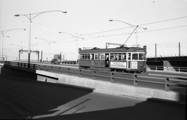 Melbourne Tram Museum
Negative, Wal Jack, 11/03/1962 12:00:00 AM
Black and white negative, by Wal Jack, of SW6 906 (North Balwyn, Route 48) eastbound on the Flinders St overpass c1960. Tram has two advertisement for Tattersall's Bonanza prize, and white crow tomato sauce. In the background is the Railway bridge with an advertisement for Western Star butter and a Morris motor car. In the far background is the Mobil oil building, which was completed during 1960.trams, tramways, sw6 class, north balwyn, flinders st, route 48, tram 906 -
 Melbourne Tram Museum
Photograph - Cable trams Collins and Swanston Sts, 1908
Black and white photograph of Collins St near the intersection of Swanston St with a Victoria Bridge cable tram in the view. Shows the buildings on both sides of the street, street lights, horse drawn vehicles and people. Not known how the photo was dated to 1908. Photo possibly from a postcard.Yields information about Collins St from Swanston St, 1908.Black and white print with notes on the rear.In ink "Collins St at Swanston St corner 1908"tramways, collins st, victoria bridge, cable trams, trams -
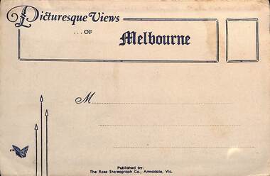 Melbourne Tram Museum
Postcard - Folder, Rose Stereograph Co, "Picturesque Views of Melbourne", mid 1930s
Comprises 12 photos of Melbourne, mid to late 1930s. Produced by Rose Stereograph of Armadale. 1 - Botanical Gardens and Government House Melbourne. - 2 - The MacRobertson Fountain Melbourne - Both the Fountain and the Shrine of Remembrance were completed in 1934. Government House tower features in the background. Also note the absence of any mature trees. See reference - completed 1934. 3 - Flinders Street Railway Station with a "W" class tram in Flinders Street and "Y" class tram in Swanston Street in the view 4 - St Kilda Road Melbourne - Looking south with the Queen Victoria Gardens in the left of the photo. 5 - Collins Street Melbourne - Showing the Regent Theatre, Manchester Unity Building and the Town Hall. 6 - Princes Bridge and city Skyline Melbourne - Shows; Princes Bridge, Yarra River, Excursion Ferry, Princes Walk, Flinders Street Railway Station, the Nicholas and Manchester Unity Buildings in Swanston Street and the Sargood Gardner building in Flinders Street. 7 - The Conservatory, Fitzroy Gardens Melbourne - 8 - The Cathedral Corner Melbourne - shows; Young & Jacksons Hotel, St Paul's Cathedral, The Gas & Fuel building, Ball & Walsh Department store and The State Theatre plus several "w" class trams in Swanston Street. 9 - St Kilda Road Melbourne - Looking south from Nolan Street. Note trees still present at the entrance area to the Shrine of Remembrance. 10 - Looking across Princes Bridge to St Kilda Road Melbourne - Looking south from the roof of the Nicolas Building showing; Princes Bridge, St. Kilda Road, The Shrine of Remembrance and the Victoria Barracks in the distance. 11 - Parliament House Melbourne - in Spring Street 12 - Captain Cook's Cottage, Fitzroy Gardens Melbourne - Erected in the gardens in 1934. Yields information about Melbourne city views and new attractions mid 1930s. Paper envelope folder with 6 photos on each side of a foldout section titled "Picturesque Views of Melbourne" melbourne, photo folders, postcards -
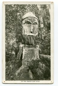 Orbost & District Historical Society
black and white photograph, 1920s
Pons asinorum was the name given to a wooden carving made by road worker Finlay Munro in the early 1920s at Boulder Creek, on the old Princess Highway, between Orbost and Cann River. The carved face was said to mock the supervising engineer after an argument about putting the road alignment across a swamp that required new bridges. The Italian workmen had advocated for a different route to avoid the need for building new bridges across the swamp. This photograph is from a set of thirteen black and white postcards in a fold-out format.This is a photograph of an iconic tourist attraction which records the woodworking skills of workers in the early 20th century. The carving is no longer there.A small black / white photograph of a face carved into a tree stump.on front at bottom - ON THE ORBOST CANN ROADwoodcarving pons-asinorum boulder-creek-east-gippsland princess-highway -
 Melbourne Tram Museum
Ephemera - Greetings card - Swanston St at Collins St - cable trams, Jack Cranston, c1905
Greetings card with a photo of Swanston St looking south from Collins St. On the left side of the photo is a cable tram signal shelter with a signal man at the levers. A St Kilda tram is southbound. Image prior to the construction of Flinders St station building. The Water Tower clock is visible at Princes Bridge Station - see reference. It was moved from Elizabeth St to Princes Bridge in 1902. The card was produced Jack Cranston and published for Glencon Insurance Assessors. See item 8448 for images of the card itself.Yields information about cable trams in Swanston St and a cable tram signalmen c1905.Greetings card with a colour photograph, printed on stippled paper.tramcars, tramways, cable trams, mtoco, swanston st, signalmen -
 Melbourne Tram Museum
Postcard, "Collins Street West", c1905
Image shows a view of Collins St West from ? street. Has a Victoria Bridge cable tram in the view. Buildings marked are Baylee & Co, Life Insurance Co., North British & Mercantile Insurance Co, Hicks Atk? Moubray - Draper. Based on date on the rear of the card 1905.Yields information about Collins St West c1905 and the nature of dress of the many men in the photo.Colour postcard - Divided back, titled "Collins Street West" with a tape boarder on the rear with pencil notes.In pencil "SPF/Melbourne - Streets - Collins Street West c1905". price of 6E and rubber stamp imprint in one corner.collins st, postcards, victoria bridge, cable trams -
Port Melbourne Historical & Preservation Society
Photograph - J Kitchen & Sons site, Port Melbourne, 1978
Large black and white aerial photo in narrow gold-coloured metal frame of J Kitchen & Sons Pty Ltd factory . Port Melbourne Football/Cricket ground top left of photo . Photo taken approx 1978 or later, dated due to types of cars and by comparison with buildings along Boundary St opposite as shown in photos of catalogue iten 3202. Dated also by Glen Cosham who was a Councillor when Woodruff St was sealed and this did not occur until after Oct 1977, probably early 1978. It was paid for by the Country Roads Board as part of the preparations for the opening of the West Gate Bridge and the Johnson St Bridge later that year.industry - manufacturing, built environment - industrial, j kitchen & sons pty ltd, pental products pty ltd, symex, north port oval