Showing 8323 items
matching bridging
-
 Lakes Entrance Historical Society
Photograph, Caire, Nicholas John, Swing Bridge Sale Victoria c1905, 1905c
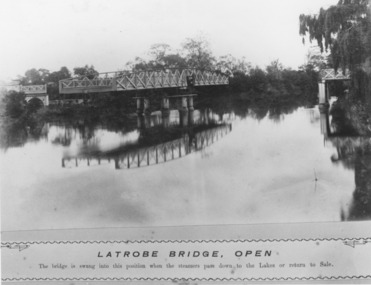
Latrobe Bridge - Open. The bridge is swung into this position when the steamers pass down to the Lakes or return to Sale.Black and white photograph of the Latrobe River Bridge over the Latrobe River, shows the bridge open to river traffic, with a good view of the supporting structure. Sale Victoriawaterways, bridges, civil engineering -
 Sunbury Family History and Heritage Society Inc.
Photograph, Catanery Bridge, Bulla, c1980s
The narrow swing catanery bridge was built behind the school across the Deep Creek downstream from the bluestone Bulla Bridge. It was built so that children who lived on the south side of Bulla Township could access the school more easily and in shorter time than if they had to go by the main roads.The bridge was constructed in the days when most children walked to school. The use of this bridge cut the children's travel time and distance to school quite considerably and was used for many years until the school was closed in 1996.A coloured photograph of the children on a narrow swing bridge and the path they used to approach the bridge over open ground. bulla primary school, swing bridge, bridges, catanery bridge -
 Phillip Island and District Historical Society Inc.
Photograph
Blessing of the Fleet Ceremony. Part of an album compiled and donated by Mrs Helen Jansson.Blessing of the Fleet Ceremony at San Remo with bridge rising in background. Large crowd on Jetty facing sea with cross behind. Elevated speaking man.No. 1. Phillip Island Bridge, Victoria - Airapy Photolocal history, photography, photographs, slides, film, civil engineering, bridges, phillip island bridge, sepia photograph, mrs helen jansson, phillip island bridge -
 Orbost & District Historical Society
black and white photographs, 1934
These photographs were taken just after the McKillop's Bridge was completed after the flood damage. The current McKillop’s Bridge was built by the Country Roads Board in two stages between 1931-36, during which its height was raised after the original bridge superstructure was washed away in record floods of January 1934, prior to its original official opening. In its reconstructed form the original concrete abutments were turned into additional piers and the welded-steel trusses were cantilevered back over them to meet the new higher road approaches. It is sited at McKillops Crossing, named after pioneer overlanding squatter George McKillop who crossed here in 1835. This was a stock crossing place for almost a century before the bridge was constructed. (info. from Victoria Heritage Register)This is a pictorial record of the history of McKillop's Bridge, in itself of historical significance for its association with Victoria's long and important pastoral history, its technicl significance and aesthetic significance.Three black / white photographs. 3133.1 shows the approach to a washed away bridge. 3133.2 is of a bridge over a river with men clearing debris. 3133.3 is a close-up showing the wreckage of the bridge.mckillop's-bridge snowy-river flood-damage-1934 -
 Lakes Entrance Historical Society
Photograph - Swan Reach Bridge, 1/12/2027 12:00:00 AM
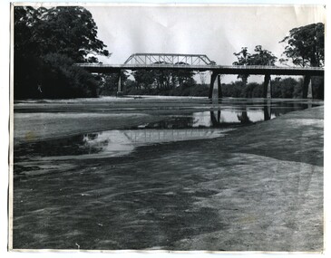
The temporary bridge was in use until for four years, following the collapse of the permanent bascule bridge on 17 November 1925 due to attack by teredo worm. The temporary bridge was swept away during a flood in June 1930.Sepia toned photograph of a pontoon bridge over the Tambo River at Swan Reach Victoria, built as a temporary crossing after the collapse of the bascule bridge on 17 November 1925. Tambo River Christmas 1927 on reversereligion, buildings -
 Phillip Island and District Historical Society Inc.
Photograph, 1969
One of 16 photographs and postcards donated by Mary KarneyBlack & White Aerial photograph of the two bridges linking San Remo with Newhaven, Phillip Island. San Remo Jetty and township bottom left foreground. Newhaven on the top.On back: "Two bridges San Remo 1969."the two bridges san remo, san remo to newhaven, phillip island bridges, mary karney -
 Phillip Island and District Historical Society Inc.
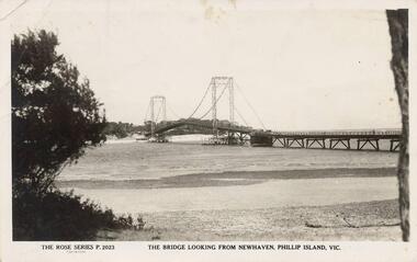
Photograph - Post Card, Suspension Bridge, 1940's
One of a collection of 18 photographs & postcards donated by Jill Yeoman. The Suspension Bridige was built during 1940. Postcard to Mrs Hughes & Lilly from Rita telling of a nice holiday visiting various towns and enjoying New Year's Eve fireworks on the Cowes beach.Black & White postcard of the Suspension Bridge from Newhaven, Phillip Island, to San Remo The Rose Series P. 2023. The bridge looking from Newhaven, Phillip Island, Vic.suspension bridge phillip island, phillip island bridge, jill yeoman -
 Melbourne Tram Museum
Photograph - Black and White - Cable tram at Queens Bridge South Melbourne
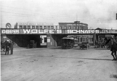
Photograph - undated, possibly prior to the First World War, shows a cable tram with the destination of Spring St passing under the Port Melbourne/St Kilda Rail lines overbridge in Queens Bridge Street. The bridge has a large advert for Wolfe's Schnapps - "for your health sake". On the left-hand side are two policemen talking to each other. There are four horse-drawn carts and one open-top motor car. In the background are Queens Bridge Motors Pty Ltd building and the Queens Bridge Family Hotel. Note the windmill on the left-hand side of the photograph. The railway bridge was partially demolished following the closure of the railway lines in 1987.Yields information about Queens Bridge Melbourne and the rail line over bridge.Black and White Photograph of a cable tram passing under the rail line over bridge at Queens Bridge South Melbourne. Two copies held.trams, tramways, cable trams, queens bridge street, queens bridge motors, queens bridge hotel, wolfe's schnapps, windmills, horse drawn vehicles, railways, port melbourne railway, st kilda railway -
 Phillip Island and District Historical Society Inc.
Photograph, 1940's
One of 20 photographs/postcards donated by Mary KarneyBlack & White photograph of roadway to the Bridge from Newhaven side.Sign across the road before the bridge: Load limit 6 tons gross - Speed limit 20 MPHsuspension bridge san remo/phillip island, phillip island suspension bridge, bridges, phillip island, mary karney -
 Robin Boyd Foundation
Slide, Commercial
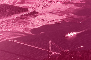
Colour slide in a mount. Lions Gate Bridge, Vancouver, Canada1490 Frances T. Vancouver, B.C / 138 / First Narrows and Lions Gate Bridge Vancouver, B.C / M6546vancouver, slide -
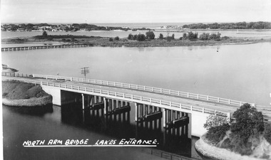 Lakes Entrance Historical Society
Postcard - North Arm bridge Lakes Entrance Victoria, The Lakes Studio, 1947
Also identical image, good condition, clearer print, collected, also enlargement 16 cm x 25.5 cmBlack and white postcard taken from the path up Kalimna Hill, showing the concrete North Arm bridge; Bullock Island; New Works area and Western side of Entrance. Lakes Entrance VictoriaNorth Arm Bridge Lakes Entrancewaterways, bridges, coast -
 Orbost & District Historical Society
postcard, C1920-1940
This photograph shows the second major bridge across the Snowy River at Orbost. The current Snowy River bridge is the fourth to provide a crossing to the township of Orbost. The first, in 1891, lasted just two years before it succumbed to flood waters. The bridge in this photograph was built in the 1920s as a road and rail bridge, and was again partly washed away by flood waters in 1934. After the end of the first World War the Victorian Railways considered an extension of the railhead across the river at Orbost, and in 1922 a new timber and steel girder structure, a joint Country Roads Board — Victorian Railways venture, was built and completed at a cost of £41,000 (the steel girders came from the Flinders Street viaduct reconstruction). Subsequently it was decided not to take the railway across the river, and the bridge was only used by road traffic. It was severely battered by floods during its life. and after the 1971 floods was eventually replaced by the current bridge in 1975. (info from Newletter 54N by John Phillips) This item is an early pictorial record of the previous Snowy River bridge at Orbost.A postcard with a black / white photograph of a bridge - timber and steel girder structure - across the Snowy River at Orbost, Reflections of the bridge are seen in the water.snowy-river-bridge-orbost -
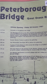 Peterborough History Group
Pamphlet, Road Construction Authority, Peterborough Bridge, 1987
Printed to celebrate the official opening of the new bridge in 1987.The bridge across he river is a major access point and the old bridge had become decrepit and the construction of the new bridge was important. The official opening was a significant event.Pamphlet for the official opening of the new bridge in 1987. 2 A4 pages with a view of the old and new bridges, describing the construction of both.curdies river, great ocean road, bridges, peterborough, peterborough bridge -
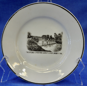 Orbost & District Historical Society
plate
This item is an early souvenir of the local district.Small white plate with black rim. Black and white illustration of the bridge over the Snowy River at Orbost.Back - Made in Orbost. Front - The Bridge Over The Snowy River At Orbost, Vic.plate souvenir snowy-river orbost -
 Orbost & District Historical Society
black and white photograph, January 1934
Damage estimated at £500,000 was caused by the 1934 floods in the Orbost district. This 1934 flood was devastating, destroying a section of the 1922 Orbost bridge, wrecking fences, bridges and roads, dumping silt and debris on the rich river flats and drowning cattle. The centre span of the Orbost Bridge was washed away. This item is a pictorial record of the 1934 floods, a significant part of Orbost's history.A black / white photograph showing the flood damage to the Snowy River Bridge. There is a gap in the bridge where the centre span has been washed away. In the background is a punt.orbost-floods-1934 natural-disasters-floods snowy-river-bridge -
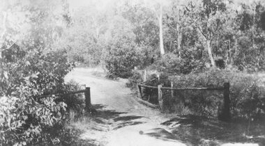
 Halls Gap & Grampians Historical Society
Photograph - B/W, C 1940- (before 1950)
Stoney creek has been 'bridged' a number of times in School Rd, since the creek was re-routed in the early 1900's. A dray bridge was built c1910 by local residents which stood them in good stead for more than a decade.Photo of 'school bridge' over Stoney Creek. Gravel road in foreground leading to a wooden bridge surrounded by tall gum trees.structures, bridges -
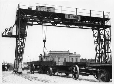 Melbourne Tram Museum
Photograph - Unloading a bridge beam ex Kelly & Lewis, Victorian Railways (VR), 1929
Photo shows a large bridge beam being unloaded at the Flinders St / Spencer St yard by an overhead crane. The beam is marked "Kelly and Lewis". Kelly & Lewis in the 1920s were making bridge beams for the Victorian Railways at their Springvale workshops. Though this photo does not appear in the PROV railway photograph collection, possibly one of the beams for the Spencer St - Clarendon St bridge that was built in 1929 . There are a number of photos of similar bridge beams for the Spencer St bridge constructed in 1929 by the Victorian Railways in the State Library. See reference for one of these.Yields information about the bridge beams possibly for the Spencer St bridge.Photograph - Unloading a bridge beam ex Kelly & LewisIn ink of rear of prints "Photo Victorian Railways"spencer st bridge, victorian railways, kelly & lewis, bridges, bridge beams -
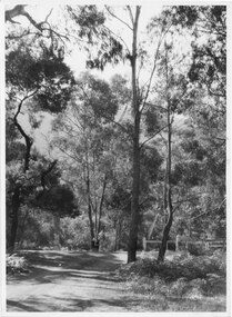
 Ringwood and District Historical Society
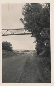
Photograph, Deep Creek bridge and road c.1935
Black and white photograph of narrow unmade road showing narrow bridge with wooded balustrades. Forested area at edge of roadway.Typed below photograph, "Deep Creek bridge and road. c.1935". -
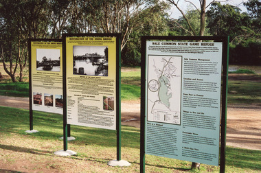 Lakes Entrance Historical Society
Photograph - Bridges, 2003
Also thirteen other photographs showing bridge open and closed.Colour photograph showing information boards giving the history of the iconic bridge and its relationship to the Gippsland Lakes historic swing bridge over the Latrobe River. The South Gippsland Highway no longer uses the swing bridge since two new bridges have been built a little upstream on the Latrobe River. Longford Victoria.bridges, waterways, local history, display -
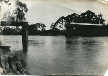
 Orbost & District Historical Society
black and white photographs, 1937
These photographs are of the bridge across the Snowy River at Orbost which was replaced in 1976. This bridge over the Snowy River was opened on July 4 1922. It was constructed in 1922 alongside the previous suspension bridge. Its building was a combined effort of the Victorian Railways and the Country Roads Board at a cost of 35,000 pounds. It was replaced in 1976 by the present bridge after several major floods.This bridge was replaced in 1976 after several major floods. This is a pictorial record of that bridge.Three black / white photographs of a truss bridge across a river.bridge-snowy-river orbost-bridge-1937 -
 National Vietnam Veterans Museum (NVVM)
Plaque - Presented Plaque
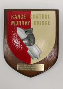
Part of the estate of Sergeant Trevor J Nicholson, who served in Royal Australian Armoured Corps, C Squadron and B Squadron 1st Armoured Regiment, 1969-70, Vietnam.Wooden plaque with cream, red, gold, silver and grey insignia of Range Control Murray Bridge, depicting a Koala riding a rocket. Beneath that is an engraved metal edication.Range Control/ Murray Bridge/ WO2 Trevor Nicholson/ Range Control Murray Bridge/ from 22/1/87 to 12/1/90range control murray bridge, 4410261 wo2 trevor nicholson., plaque, nicholson, t nicholson, shield, trevor nicholson, 4410261 -
 Bendigo Historical Society Inc.
Document - Newspaper Articles from Bendigo Advertiser
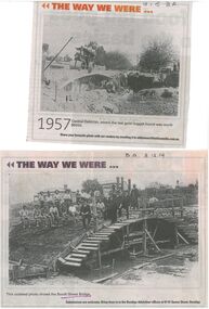
In 1867, Frenchman Joseph Monier patented the use of metal reinforced concrete for use in horticultural troughs. Francois Hennebique expanded this idea into a general construction technique including for the construction of bridges bridges with the first bridge built in 1875. In Victoria, Monash and Anderson, representatives of the Australian patent holders and later Victorian patent holders. The Bendigo Monier Bridges were built between 1901 and 1902. Monash's contribution was not in the actual technology but in the promotion and defence of the new technology that was faced by much doubt and scepticism.Series of Bendigo Advertiser articles on the theme of Monier Bridges. Five articles from "Discover Bendigo" by James Lerk. 1999 One article from "History Lives" by Jim Evens titled 'Building History Bridges" 2014 Two black and white photos from "The Way we Were" featuring the construction of the Booth Street Bridge 2014 and the collapse of the King Street bridge 2015.monier bridges, engineering -
 City of Ballarat
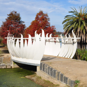
Artwork, other - Public Artwork, Swan Pool Bridge By Thomson Hay Landscape Architects, c2013
Swan Pool forms the southern gateway to the ‘Fairyland’ area on the western shore of Lake Wendouree, Ballarat. The new bridge was built c2013 and designed based on the form of water lily flowers. The sculptural form of the bridges enhances the ‘Fairyland’ experience for children and adults alike.white decorative steel bridge edgings -
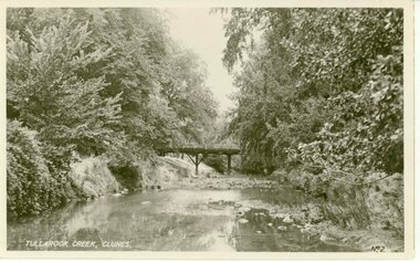 Clunes Museum
Photograph
THIS BRIDGE WAS DEMOLISHED IN 1962 AND A NEW BRIDGE WAS ERECTED.BLACK AND WHITE PHOTOGRAPH OF JUBILEE OR QUEEN'S BRIDGE OVER TULLAROOK CREEK, CLUNES.TULLAROOK CREEK, CLUNESlocal history, photography, photographs, bridges -
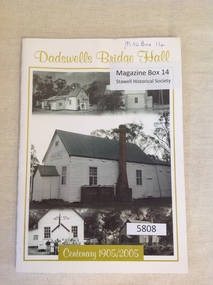 Stawell Historical Society Inc
Book, Rhonda Poholke, Dadswells Bridge Hall Centenary 1905/2005, 2005
A book commemerating the Centenary of the Dadswells Bridge HallWhite Card with lime green print and border enclosing five b/w photos of the Dadswells Brigde Hall.Dadswells Bridge Hall Centenary 1905-2005stawell -
 El Dorado Museum Association Inc.
Photograph - Digital Image
Mulls Bridge, from Daddy Simpsons Album.Digital image copied from a black and white photograph of a bridge over a creek joining an unsealed road leading to a house on a rise overlooking the bridge.bridge, creek, el dorado, eldorado -
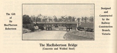 Victorian Interpretive Projects Inc.
Image, MacRobertson's Bridge, 1934
Confectionery king MacPherson Robertson personally funded the £19 000 cost of the steel arch MacRobertson or Grange Road Bridge (1934) as a gift to Victoria for its centenary. (http://www.emelbourne.net.au/biogs/EM00234b.htm)A steel bridge over the Yarra River, Melbourne. The bridge was funded by MacPherson Robertson.macrobertson, bridge -
 Phillip Island and District Historical Society Inc.
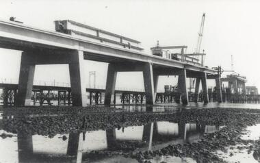
Photograph, Phillip Island Bridge, 1968/9
1969 Bridge construction showing Suspension Bridge in background.Girders on partly built Bridge. Crane in background - close-up at low tide.local history, photographs, civil engineering, bridges, phillip island bridge (1969), black & white photograph, jack jenner collection, phillip island bridges, public construction -
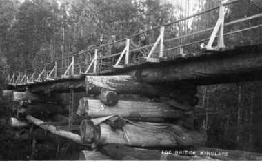 Kinglake Historical Society
Log Bridge Kinglake
post card depicting horse and cart crossing log bridge at Kinglakeearly post card of Kinglake area including bridge and transportpost card of log bridge Kinglakekinglake, post card, log bridge, horse cart -
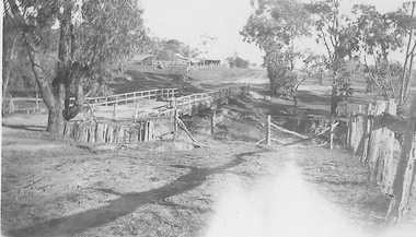
 Kiewa Valley Historical Society
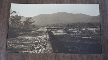
Photos - Tawonga Bridge x 2
The first Tawonga bridge was built in 1884. It was destroyed by floods in 1916. The new bridge was constructed in 1923 and destroyed in 1953. The present concrete bridge was constructed in 1986 and named Ryders Bridge. Also refer to ?KVHS 0962 and KVHS 1051, KVHS 1090, KVHS 1123Bridge constructed over the Kiewa River in 1923 and destroyed in 1953.1. Dark Brownish photo framed by thin wood. Photo shows bridge with mountain behind and river and river bank in the foreground. 2. Small photo showing 2 sides of the bridge - a close up view.tawonga bridge, kiewa valley, kiewa river