Showing 673 items matching "camp road"
-
 Halls Gap & Grampians Historical Society
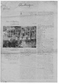
Document - Fax of article (magazine/newspaper)
The article is c.1993. Chautauqua peak is named after the Chautauquans, who held summer camps in Halls Gap in the 1890s. NOTE: Additional images are second and third pages, and a Microsoft Word file which includes the text of all three pages. A PDF file of an "augmented copy of the fax (with the more difficult to read sections clarified in pencil) is also available in the \Pictures\MP Navigator\2009_09_-02 directory on the computer (as there is not further space to attach it to this record)A copy of a three page National Geographic Traveler article entitled 'An enduring tradition'. The article describes the reporter's trip to Lake Chautauqua where the Chautauqua Institution was founded, and includes historical information about the Chautauquans.Chautauqua written in ball-point pen on top of front page.media, magazine articles -
 Halls Gap & Grampians Historical Society
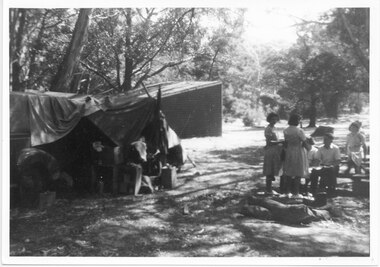
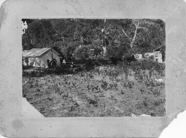
Photograph - B/W, C 1940s
This is a photo of the Zumsteins camping area, which was popular with families.The photo shows a group of six people, two standing near, and four seated at, a picnic table. There is a large canvas tent/structure with boxes and tins at the entrance to the left and behind it there is a corrugated iron building. The area is surrounded by bush.recreation, camping, scenery, zumsteins -
 Halls Gap & Grampians Historical Society
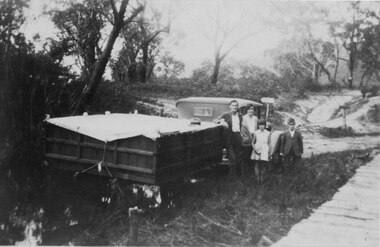
Photograph - B/W, C 1932
A family on holiday in the Grampians. The deep wagon is an early form of caravan, which folded down and was ready to erect when a site was found. The man is Jack Diamond from Donald.The photo shows a family (a man, a woman, a girl and a boy) standing beside an old car pulling a deep, wooden wagon covered by a tarpaulin. A mans hat sits on the tarpaulin near the man's elbow.The wagon appears to be standing in water and there is a wooden slat surfaced bridge ortrestle to the right. A track with two signposts is in front of the car and there is thin bush in the background.recreation, camping, transport, cars -
 Halls Gap & Grampians Historical Society
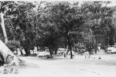
Photograph - B/W
Campsites along the road leading to the Halls Gap shops.The photo shoes tents and cars amongst the bush beside a dirt road. Three people can be seen sitting/reclining on a rug in the right foreground.recreation, camping -
 Halls Gap & Grampians Historical Society
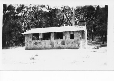
Photograph - B/W
This was the Camp Kitchen in the Halls Gap Camping ReserveThe photo shows a stone building with glassless windows and an iron roof standing in a clearing with bush behind.structures, camp kitchens -
 Halls Gap & Grampians Historical Society
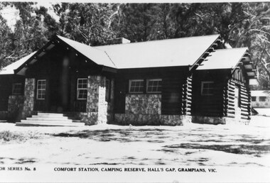
Postcard - B/W
This is a photo of the Comfort Station at the Halls Gap Camping Reserve. The Camp Kitchen (see record 375) can be seen in the right, rear of the photo .The photograph shows a building, constructed from logs and stone. Steps lead up to the door and the building has small, paned windows alond the front. There is bush in the background and a smaller stone building can be seen at the right rear. "...or Series No. 8. Comfort Station, Camping Reserve, Hall's Gap, Grampians, Vic." on bottom of postcard.buildings, comfort stations -
 Halls Gap & Grampians Historical Society
Photograph - B/W
This is a photo of a camps site at the base of Mackeys Peak. The Willoughby's are camped on the left, The Barnes in the centre and the Hines on the right (presumably the people in the photo are from these family groups).The photo shows tents in a clearing in bush.There is a large tent to the right with a man and a young child in front of it, another tent or structure can be seen on the left with a group of four adults and two children lined up in front of it. A buggy can be seen in the bush in the centre.Camp at base of Mackey's peak, Willoughby's camp, Barnes Camp Hines Camp, written in pen on back of mount.recreation, camping, scenery, grampians ranges -
 Halls Gap & Grampians Historical Society
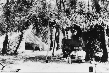
Photograph - B/W
This is a photo of camping in the Wannon Valley.The photo shows a man sitting on the ground, holding a book, leaning against the back of a trailer/utility. The trailer appears to be covered by a shelter made of tree branches. There is a large tent with an open flap in the left background and a billy hanging on a tripod made of branches can be seen in the right foreground. The area is surrounded by bush.recreation, camping -
 Halls Gap & Grampians Historical Society
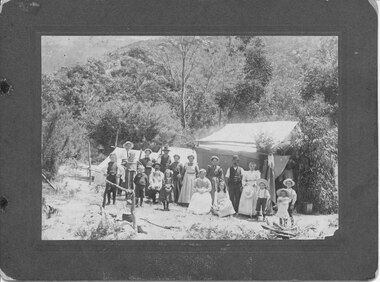
Photograph - B/W, C 1903
The Willoughby's, Lawsons & Goodsons, camping at the base of Mackey's Peak near the child's grave. The back of the mount records that there are four Goodsons, G'dma Sarah Campbell, Aunty Thomson's Grandmother, Glad Jones (Cashin), Jim W(illoughby) nursing Mavis McAllen, Allan's Mother (not clear if Mavis McAllen is "Allan's Mother" or if Allan's Mother is another person in the photo), Clarice Willoughby, Allen W(illoughby), four Lawsons.The photo shows a large group of people (men, women and children) standing in front of a group of three tents in a clearing. The area is surrounded by bush. In the left foreground there is a cauldron hanging from a stand mad;'e of branches over a fireplace."Willoughby's camp at Halls Gap near child's grave 1903. 4 Goodsons, G'dma Sarah Campbell, Aunty Thomson's Grandmother, Glad Jones (Cashin), Jim W. nursing Mavis McAllen, Allan's Mother, Clarice Willoughby, Allen W., 4 Lawsons" hand written in blue ink on back of mount.recreation, camping -
 Halls Gap & Grampians Historical Society
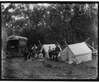
Photograph - B/W
The photo shows a hawkers wagon and camp in the Wartook area.The photo shows two tents, side by side, with a wagon to the left of them. There are three women sitting, a man kneeling and another standing in front of the left hand tent, and a man and two boys standing to the left of the right hand tent. There is bush in the background.recreation, camping, people, hawkers -
 Halls Gap & Grampians Historical Society
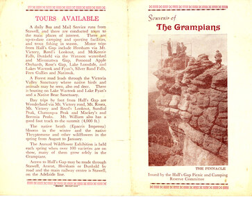
Flyer - Coloured, C mid-1950s
This is a pamphlet from before electric light was connected to the campground. The pamphlet mentions that electric light and a hot water service will be installed for the 1956-57 season. Record 385 is a later version of the same pamphlet ,after the electric lights were installed. The front and back pages are shown as the main photo and the centre pages are available under 'Additional Images'.This is a four page, folded pamphlet entitled Souvenir of the Grampians, which was issued by the Hall's Gap Picnic and camping Reserve Committee. It has a large photo of 'The Pinnacle' on the front. The centre pages contain a photo of the 'Comfort Station', a History of the Grampians, a dot-point list of Camp Ground Facilities and information about the Hall's Gap Picnic and Camping Reserve. The back page has details of Tours Available.media, flyers -
 Halls Gap & Grampians Historical Society
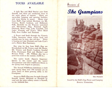
Flyer - Coloured, C late1950s
This is a pamphlet from after electric light was connected to the campground. The pamphlet mentions that electric light and a hot water service have been installed. Record 384 is an earlier version of the same pamphlet, before the electric lights were installed. The front and back pages are shown as the main photo and the centre pages are available under 'Additional Images'. This is a four page, folded pamphlet entitled Souvenir of the Grampians, which was issued by the Hall's Gap Picnic and camping Reserve Committee. It has a large photo of 'The Pinnacle' on the front. The centre pages contain a photo of the 'Comfort Station', a History of the Grampians, a dot-point list of Camp Ground Facilities and information about the Hall's Gap Picnic and Camping Reserve. The back page has details of Tours Available.media, flyers -
 Halls Gap & Grampians Historical Society
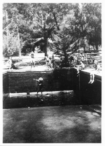
Photograph - B/W
The photo shows the first pool in the Halls Gap Picnic & Camping Reserve being cleaned.The photo shows an empty swimming pool There is a man wearing a large hat in the pool using a long handled brush. A number of people, both adults and children, are seated and walking around the edge of the pool. A wood log seat can v=be seen to the right of the pool with a woman sitting on it. There is a building visible among trees in the background.recreation, swimming pool -
 Heidelberg Repatriation Hospital
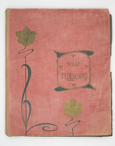
Album - Photograph WWI, c.1913-1916
Red cloth hard cover photo album with Art Nouveau design on cover and green paper pages, containing black and white photographs from the World War One era of soldiers abroad and family. Some formal studio photography. Subject matter includes: Middle East, France, Egypt, Horses, Zoo visit, well digging, horse in a hammock, hotels and souvenir cards, North Africa, camels, camps, tents, donkeys, ships, portraits, sports teams, Ypres in Belgium, Folkestone UK, Camp at Burrumbeet 1913 and another dated photograph reads 30th May 1916. Photographs are stuck down onto pages. Cover reads: SCRAP ALBUMwwi, world war one, soldiers, aif, anzac, portraits, photo albums, grand continental cairo, jb ballardie, william harrigan, ypres, cairo, 54th bn, t.s.s. borda, la rue au beurre, leas bandstand & parade folkestone -
 Halls Gap & Grampians Historical Society
Photograph - B/W, C 1946
A photo of the Comfort Station in the Halls Gap Picnic and Camping Reserve.The photo shows a wood and stone building at the rear of a clearing with a large eucalyptus tree growing close to the front of it. In the background is heavy bush. A tent or large cloth can be seen on the right beside a large tree stump.buildings, mountain grand -
 Halls Gap & Grampians Historical Society
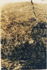
Photograph, C 1920s
This is a photo of the Mt. Victory Road under construction. The workers camp can be seen in front of the road. For further information see 'Victoria's Wonderland', pp 102, 112 & 136. Note: The second copy is a transparency held at Slide Box No. 162.The photo shows a slope covered in thick bush. A road can just be seen in the middle foreground and a campsite with many tents can be seen through the bush in front of the road.access routes, mt victory rd -
 Halls Gap & Grampians Historical Society
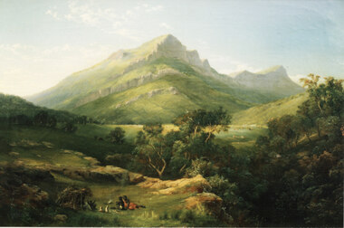
Photograph - Coloured
This is a photo of a painting by Nicholas Chevalier (1828-1902). The painting is "Mt Abrupt, Grampians", circa 1864, oil on canvas, 46.0 x 61.0 cm (held in a private collection, London).This is a photo of a painting. It shows a stylised view of a mountain with a further peak behind it. The front of the peaks have high, rock cliffs. In the foreground there is an aboriginal camp, including a shelter with two people sitting in it, two people and two dogs sitting outside on the grass and a camp fire between them and the hut.painting, landscape -
 Halls Gap & Grampians Historical Society
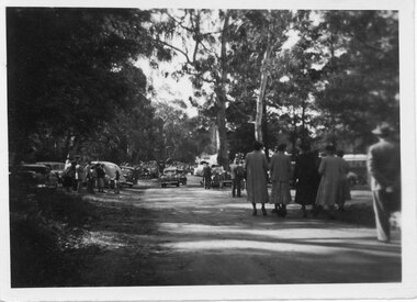
Photograph - B/W, C 1950
Halls Gap Grampians Camping reserve on Flower Show Day in 1950. This is the main road looking towards the stores from Grampian House.The photo shows a road with trees growing on either side. There are cars parked on either side of the road and people standing and walking along the road. In the centre there are two cars driving along the road towards the camera.events, wildflower show -
 Halls Gap & Grampians Historical Society
Photograph - Photocopy, C 1925
The woman's name is Mavis Klauss and the boy is Arthur Klauss. The bridge is over the McKenzie Creek at Zumsteins. The Klauss family often camped in this area.The photo shows a woman and boy sitting on a bridge dangling their feet over a wide creek. A horse is teathered in the background on the left of the photo, where a building can also be seen.people, klauss, structures, bridges -
 Halls Gap & Grampians Historical Society
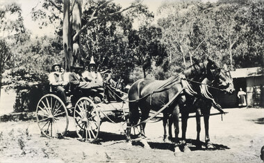
Photograph - B/W, C 1920s ?
c 1920s ? The cottage was known as "Gray's Cottage" and was one of a number in the campground that could be rented for the holidaysPhoto mshows four men in a gig drawn by two horses. A bundle (camping gear) is stowed in front of the gig. A hurricane lamp can be seen on top of the hear in front. On the right a building can be seen, with a woman wearing an apron in the doorway. The building front (presumably the verandah) is weatherboard with the upper half being lattice. Another building (? shed) can be seen vaguely on the left. Large gums and bush are seen in the background.recreation, camping, transport, horse drawn -
 Halls Gap & Grampians Historical Society
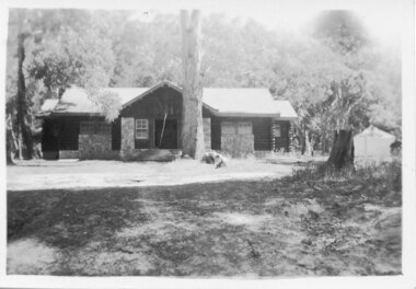
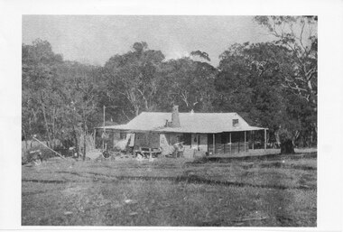
Photograph - Photocopy
This house belonged to Walter Zumstein of the Zumsteins area. The house was burnt down in 1938. Photo was taken by Stan Parfett whose own family camped in the Zumstein area and knew Mr and Mrs Zumstein personally. c1920's This is an photocopied enlargement from a photocopied magazine article, Victoria's Heritage (see item 637)A house with veranda. A chimney (stone?) protrudes from roof at front. cleared land in foreground with old style wooden fence visible. A tank and stand situated beside house at front. Thick trees /Bush behind house.House Burnt 1938. Walter Zumstein's house. Photo by Stan Parfett. written on back.buildings, houses -
4th/19th Prince of Wales's Light Horse Regiment Unit History Room
Framed Colour Photo
Annual camp of 4/19 Prince of Wales's Light Horse Regiment, in desert country of Northern Victoria, about 1982 Colour photo of squadron of M113A1 of 4/19 Prince of Wales's Light Horse Regiment parked nose to tail on dirt road in desert country of Northern Victoria. Crews are on tops of vehicles waiting for something to happen. In glass fronted wooden frame. Landscape orientation. desert camp, m113a1, -
 Eltham District Historical Society Inc
Photograph, Spring Excursion, Hume and Hovell bus tour Stage 2, Seymour, Benalla; 26 Oct 1997, 26/10/1997
MONUMENT HUNTING THE HUME AND HOVELL WAY (Newsletter No. 117, November 1997, by Diana Bassett-Smith) Sunday October 26 1997 dawned bright and very warm. Some twenty-five members, complete with picnic baskets, met outside the Eltham Library awaiting the Cobb and Co. large coach which would be taking us on the second leg of our travels along the route of the early explorers Hume and Hovell. Stephen West was our very good driver for the day. He would be guided around the circuitous route by Russell Yeoman wh9 had made a detailed study, not only of the intended route, but of the story of these two explorers. During the trip Russell regaled us with poetry, quotations from the Journals and the History of the Shire of Seymour, "The New Crossing Place: by Martindale, 1982, (now Mitchell Shire due to the recent amalgamations). We headed towards the Hume Highway via Greensborough and Cooper Street and proceeded north to our first stop, noting on the way Monument Hill in the distance which is near Kilmore and, according to Russell, well worth the effort to visit as the view across the valley is magnificent. Past Sunday Creek Valley, Mt Piper and Mt Disappointment, all traversed and noted and named by them. We passed through Tallarook, then onto Seymour where we took photos of the monument telling us that Hume and Hovell had passed through on the 28th of October 1824. We also deviated down Hume and Hovell Road viewing deer and emu farming and the Bellbourie property now a sanctuary. Leaving Seymour behind we travelled up the Avenel Road to the Avenel monument, pyramidal in design of four reducing square blocks with a sharply pointed peak, erected in 1924 in memory of the 1824 exploration. The day was warming up and the countryside showing the dryness of the current drought. A parallel note had been made in their journal too of 1824 of the drought appearance of the country they were traversing. At Seven Creeks, Euroa we stopped for some minutes to check the monument placed 20th November 1924 to commemorate their passage on the 29th December 1824. More photos. Russell had pointed out the abrupt termination of the distant ranges which is noted in their journal. The next monument is beside the road at the entrance to Honey Suckle Creek Caravan Park, Violet Town. The squarish shaped monument some eight feet high is topped with a simple steel cross, and was to mark the date of 28th December 1824 and built for the 20th November 1924. By now it was 12.20 and nearly lunchtime as we drove along the Warranbayne Road to Roach's Road, monument hunting without success. Though there is a large, what appears to be an old timber sign which was hard to read, maybe this was the lost monument. In many of the paddocks hay had been cut and baled or was being cut, what a contrast to the rugged country they had passed through which was smoky from the fires of the natives burning off By 1.00 pm we were at Benalla and pulled up beside the park where abundant beds of roses filled the air with their scent and the smell of barbecued food twitched the nostrils whilst the cheerful sounds of other picnickers could be heard throughout the park. We left the bus and collected up our picnics, dispersed to the various tables and enjoyed the shade from the various European trees. 2.00 pm and we were on the road again driving along the Benalla, Mansfield, Yea road. The Swanpool monument states that they passed four miles south and returned three miles north. Then we stopped at the Barjarg monument which notes that they camped near this spot. It is again a pyramidal monument and this time topped with a steel arrow indicating their route of the 29th November 1824. Half an hour later we came to another monument, again with a steel arrow marker on top and the plaque dated the 2nd of 12th 1824. Erected on the 12th of 12th 1924. "They blazed the way that we might inherit the land." Another square based and needle topped monument appeared at Yarck near Yea and this plaque records the date of 3 December 1824. Near McGuigans Road Russell related that the expedition had lost a dog but it had found them next day, the dog was apparently torn by a kangaroo. A short while later Russell reminded us here of the problems they encountered in crossing the Goulburn River near Molesworth where banks were high, water deep and wide. "Good coat of grass but quite dry due to drought". At Yea we stopped for afternoon tea and raided the last of our picnics and looked at the monument to their journey of 1824, situated at a corner of the gardens near the bowling green. No photo – we were out of film. We returned home via Kinglake West and Whittlesea past the Yan Yean Reservoir, not full. 5.00 pm back at Eltham we emptied out of the bus and everyone, including Joan Cole, collected their things, Joan also had the major souvenir of the day, a large carp she had picked up from the river bank, her cat was in for a great feast. The day was made so interesting by the informed commentary which Russell provided. His background knowledge of the route and nature of the journey could only have come from many hours of reading and driving the area. Thank you to Russell and to everyone who made the day so informative and pleasurable. Diana Bassett-Smith. Record of the Society's history of activities - Spring 1997 excursionRoll of 35mm colour negative film, 6 stripsFuji 200shire of eltham historical society, activities, pretty hill, seymour, benalla, hume and hovell, monuments -
 Eltham District Historical Society Inc
Photograph, Spring Excursion, Hume and Hovell bus tour Stage 2, Seymour, Benalla; 26 Oct 1997, 26/10/1997
MONUMENT HUNTING THE HUME AND HOVELL WAY (Newsletter No. 117, November 1997, by Diana Bassett-Smith) Sunday October 26 1997 dawned bright and very warm. Some twenty-five members, complete with picnic baskets, met outside the Eltham Library awaiting the Cobb and Co. large coach which would be taking us on the second leg of our travels along the route of the early explorers Hume and Hovell. Stephen West was our very good driver for the day. He would be guided around the circuitous route by Russell Yeoman wh9 had made a detailed study, not only of the intended route, but of the story of these two explorers. During the trip Russell regaled us with poetry, quotations from the Journals and the History of the Shire of Seymour, "The New Crossing Place: by Martindale, 1982, (now Mitchell Shire due to the recent amalgamations). We headed towards the Hume Highway via Greensborough and Cooper Street and proceeded north to our first stop, noting on the way Monument Hill in the distance which is near Kilmore and, according to Russell, well worth the effort to visit as the view across the valley is magnificent. Past Sunday Creek Valley, Mt Piper and Mt Disappointment, all traversed and noted and named by them. We passed through Tallarook, then onto Seymour where we took photos of the monument telling us that Hume and Hovell had passed through on the 28th of October 1824. We also deviated down Hume and Hovell Road viewing deer and emu farming and the Bellbourie property now a sanctuary. Leaving Seymour behind we travelled up the Avenel Road to the Avenel monument, pyramidal in design of four reducing square blocks with a sharply pointed peak, erected in 1924 in memory of the 1824 exploration. The day was warming up and the countryside showing the dryness of the current drought. A parallel note had been made in their journal too of 1824 of the drought appearance of the country they were traversing. At Seven Creeks, Euroa we stopped for some minutes to check the monument placed 20th November 1924 to commemorate their passage on the 29th December 1824. More photos. Russell had pointed out the abrupt termination of the distant ranges which is noted in their journal. The next monument is beside the road at the entrance to Honey Suckle Creek Caravan Park, Violet Town. The squarish shaped monument some eight feet high is topped with a simple steel cross, and was to mark the date of 28th December 1824 and built for the 20th November 1924. By now it was 12.20 and nearly lunchtime as we drove along the Warranbayne Road to Roach's Road, monument hunting without success. Though there is a large, what appears to be an old timber sign which was hard to read, maybe this was the lost monument. In many of the paddocks hay had been cut and baled or was being cut, what a contrast to the rugged country they had passed through which was smoky from the fires of the natives burning off By 1.00 pm we were at Benalla and pulled up beside the park where abundant beds of roses filled the air with their scent and the smell of barbecued food twitched the nostrils whilst the cheerful sounds of other picnickers could be heard throughout the park. We left the bus and collected up our picnics, dispersed to the various tables and enjoyed the shade from the various European trees. 2.00 pm and we were on the road again driving along the Benalla, Mansfield, Yea road. The Swanpool monument states that they passed four miles south and returned three miles north. Then we stopped at the Barjarg monument which notes that they camped near this spot. It is again a pyramidal monument and this time topped with a steel arrow indicating their route of the 29th November 1824. Half an hour later we came to another monument, again with a steel arrow marker on top and the plaque dated the 2nd of 12th 1824. Erected on the 12th of 12th 1924. "They blazed the way that we might inherit the land." Another square based and needle topped monument appeared at Yarck near Yea and this plaque records the date of 3 December 1824. Near McGuigans Road Russell related that the expedition had lost a dog but it had found them next day, the dog was apparently torn by a kangaroo. A short while later Russell reminded us here of the problems they encountered in crossing the Goulburn River near Molesworth where banks were high, water deep and wide. "Good coat of grass but quite dry due to drought". At Yea we stopped for afternoon tea and raided the last of our picnics and looked at the monument to their journey of 1824, situated at a corner of the gardens near the bowling green. No photo – we were out of film. We returned home via Kinglake West and Whittlesea past the Yan Yean Reservoir, not full. 5.00 pm back at Eltham we emptied out of the bus and everyone, including Joan Cole, collected their things, Joan also had the major souvenir of the day, a large carp she had picked up from the river bank, her cat was in for a great feast. The day was made so interesting by the informed commentary which Russell provided. His background knowledge of the route and nature of the journey could only have come from many hours of reading and driving the area. Thank you to Russell and to everyone who made the day so informative and pleasurable. Diana Bassett-Smith. Record of the Society's history of activities - Spring 1997 excursionRoll of 35mm colour negative film, 6 stripsFuji 200shire of eltham historical society, activities, pretty hill, seymour, benalla, hume and hovell, monuments