Showing 750 items matching "chart"
-
 Victorian Aboriginal Corporation for Languages
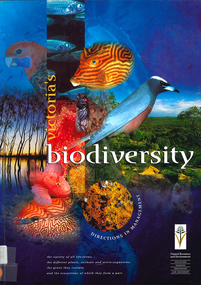
Book, Department of Natural Resources and Environment, Victoria's biodiversity : directions in management, 1997
Looking at Victoria in each region and examining the biodiversity of the environment, for management purposes.Maps (including two large maps) charts, graphs, colour photographs,biodiversity, sustainability, conservation -
 Bendigo Historical Society Inc.
Document - MCCOLL, RANKIN AND STANISTREET COLLECTION: NELL GWYNNE SYNCLINE
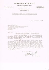
Manilla folder of documents relating to the Nell Gwynne Syncline Mining lease. Mentioned are Lease No.'s 10875 and 10903 which is in the Empire Road Stray Street area; R. Lethlean's Sluicing Claim; Albert Selisky has permissive Occupancy on ¼ acre; New Chum Syncline; Liddell's Chenical and Metallurgical Works; Arum Dredging Development NL. Application for a Hydraulic Sluicing Lease; Transfer of lease No. 10903, from H.J. Leed to North Nell Gwynne Gold Mines NL; Application form for the Nell Gwynne Syncline Co.. Application for leases 10945 and 10946; Nell Gwynne Syncline option to purchase lease 10945 for £1,000; Consent from Minna Matilda Lawson for inclusion of part of allotment 268 in lease No. 10875.Dickson & Tadgell Charted Accountants, 95 Queen Street, Melbourne C1gold, mining, land application, nell gwymme syncline, gold mines, bendigo -
 Flagstaff Hill Maritime Museum and Village
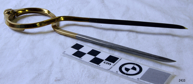
Functional object - Map Calipers/ Divider, Unknown
Compass, divider, and caliper are basically instruments that have two legs pivoted to each other at the top and are concerned with small-distance measurement or transfer. The compass and divider have straight legs; the caliper has curved legs. Dividers and Calipers were known to both the Greeks and Romans, though the caliper was uncommon. A divider with a circular sector, or wing, connecting the two legs was sketched in 1245, its modern counterpart is the wing divider with a thumbscrew clamp and screw for fine adjustment. Or the marine dividers used to measure the distance a vessel has travelled by transferring the vessels distance from a map with the divider and transferring that measurement to a marine ruler to mathematical calculate the distance.Item is believed to be a replica/ copy of a 19th century map calipers used in marine navigation to determine distance travelled. Item was probably purchased between 1972-1975 to add to the marine displays at Flagstaff Hill.Stainless steel dividers used in navigation charts. Top half is alloy plated. "W & HC" and "Made in England".flagstaff hill, warrnambool, shipwrecked-coast, flagstaff-hill, flagstaff-hill-maritime-museum, maritime-museum, shipwreck-coast, flagstaff-hill-maritime-village, stainless steel dividers, steel dividers, dividers -
 Flagstaff Hill Maritime Museum and Village
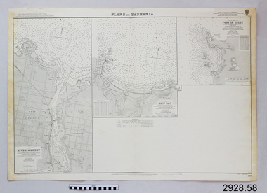
Document - Navigation Chart, Plans in Tasmania - Foster Inlet, River Mersey and Emu Bay
Navigation Chart - Plans in Tasmania - Foster Inlet, River Mersey and Emu Baywarrnambool, shipwrecked-coast, flagstaff-hill, flagstaff-hill-maritime-museum, maritime-museum, shipwreck-coast, flagstaff-hill-maritime-village, shipwrecked-artefact, river mersey, foster inlet, emu bay, navigation chart -
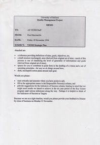 Federation University Historical Collection
Document - Document - Project, VIOSH: University of Ballarat, Strategic Plan; Quality Management Project 1994
Victorian Institute of Occupational Safety and Health (VIOSH) Australia is the Asia-Pacific centre for teaching and research in occupational health and safety (OHS) and is known as one of Australia's leaders on the field. VIOSH has a global reputation for its innovative approach within the field of OHS management. VIOSH had its first intake of students in 1979. At that time the Institution was known as the Ballarat College of Advanced Education. In 1990 it became known as Ballarat University College, then in 1994 as University of Ballarat. It was 2014 that it became Federation University. VIOSH Australia students are safety managers, senior advisors and experienced OHS professionals. They come from all over Australia and industry. Students are taught active research and enquiry; rather than textbook learning and a one-size fits all approach. VIOSH accepts people into the Graduate Diploma of Occupational Hazard Management who have no undergraduate degree - on the basis of extensive work experience and knowledge. Memo from Don Maconachie was sent to all VIOSH Staff in relation to the development of a VIOSH Strategic Plan. They were to develop value statement, vision statement, aims, goals, objectives, targets, strategies. Staff provided with forms to be completed coving these aspects. They were to state the responsible person, timeline, target groups, resources required and indicators of success. On completion results compiled and given to staff. Report would then be sent to Director of VIOSH Australia.Forty-two pages that was stapled together in sections. Type written with relevant charts.viosh, victorian institute of occupational safety and health, quality management project, visor strategic plan, don maconachie, mission statement, aims, targets, director -
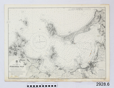 Flagstaff Hill Maritime Museum and Village
Document - Navigation Chart, Japan, Fukuoka Wan - Kyushu - North Coast
British Admiralty Navigation Chart - Japan, Fukuoka Wan - Kyushu - North Coastwarrnambool, shipwrecked-coast, flagstaff-hill, flagstaff-hill-maritime-museum, maritime-museum, shipwreck-coast, flagstaff-hill-maritime-village, shipwrecked-artefact, british admiralty, navigation chart -
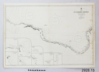 Flagstaff Hill Maritime Museum and Village
Document - Navigation Chart, Ras Makhabez to Bengazi
British Admiralty Navigation Chart - Africa, North Coast - Ras Makhabez to Bengaziwarrnambool, shipwrecked-coast, flagstaff-hill, flagstaff-hill-maritime-museum, maritime-museum, shipwreck-coast, flagstaff-hill-maritime-village, shipwrecked-artefact, ras makhabez to bengazi, british admiralty navigation chart, navigation chart -
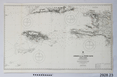 Flagstaff Hill Maritime Museum and Village
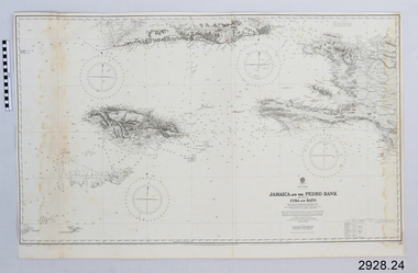
Document - Navigation Chart, Jamaica and the Pedro Bank
British Admiralty Navigation Chart - Jamaica and the Pedro Bank with part of Cuba and Haitiwarrnambool, shipwrecked-coast, flagstaff-hill, flagstaff-hill-maritime-museum, maritime-museum, shipwreck-coast, flagstaff-hill-maritime-village, shipwrecked-artefact, navigation chart, british admiralty navigation chart, pedro bank, jamaica -
 Flagstaff Hill Maritime Museum and Village
Document - Navigation Chart, Jamaica and the Pedro Bank
British Admiralty Navigation Chart - Jamaica and the Pedro Bank with parts of Cuba and Haitiwarrnambool, shipwrecked-coast, flagstaff-hill, flagstaff-hill-maritime-museum, maritime-museum, shipwreck-coast, flagstaff-hill-maritime-village, shipwrecked-artefact, navigation chart, british admiralty navigation chart, pedro bank, jamaica -
 Flagstaff Hill Maritime Museum and Village
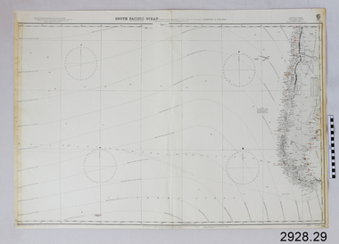
Document - Navigation Chart, South Pacific Ocean - Melbourne to Cape Horn
British Admiralty Navigation Chart - South Pacific Ocean - Melbourne to Cape Hornwarrnambool, shipwrecked-coast, flagstaff-hill, flagstaff-hill-maritime-museum, maritime-museum, shipwreck-coast, flagstaff-hill-maritime-village, shipwrecked-artefact, navigation chart, british admiralty navigation chart, melbourne to cape horn, south pacific ocean -
 Flagstaff Hill Maritime Museum and Village
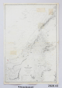
Document - Navigation Chart, China Sea
British Admiralty Navigation Chart - China Sea, Southern Portion - Eastern Sheetwarrnambool, shipwrecked-coast, flagstaff-hill, flagstaff-hill-maritime-museum, maritime-museum, shipwreck-coast, flagstaff-hill-maritime-village, shipwrecked-artefact, navigation chart, british admiralty navigation chart, british admiralty, china sea -
 Flagstaff Hill Maritime Museum and Village
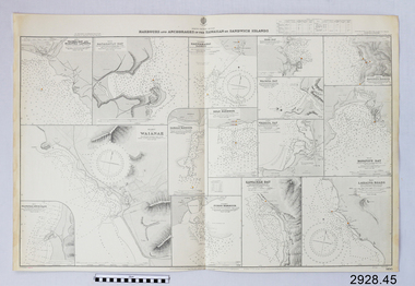
Document - Navigation Chart, Harbours and Anchorages in the Hawaiian Islands or Sandwich Islands
British Admiralty Navigation Chart - Harbours and Anchorages in the Hawaiian Islands or Sandwich Islandswarrnambool, shipwrecked-coast, flagstaff-hill, flagstaff-hill-maritime-museum, maritime-museum, shipwreck-coast, flagstaff-hill-maritime-village, shipwrecked-artefact, navigation chart, british admiralty navigation chart, british admiralty, hawaiian islands -
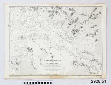 Flagstaff Hill Maritime Museum and Village
Document - Navigation Chart, A San Anchorage and Approaches
British Admiralty Navigation Chart - Korea - West Coast - A San Anchorage and Approacheswarrnambool, shipwrecked-coast, flagstaff-hill, flagstaff-hill-maritime-museum, maritime-museum, shipwreck-coast, flagstaff-hill-maritime-village, shipwrecked-artefact, navigation chart, british admiralty navigation chart, british admiralty, a san anchorage and approaches -
![Genealogical chart, Chapman family [James Chapman/Susan Palmer], 1744o](/media/collectors/4f729f5697f83e03086015b8/items/50a4628f2162ef10601bdce5/item-media/58be7236d0ce7205ecb82f1f/item-fit-380x285.jpg) Greensborough Historical Society
Greensborough Historical SocietyGenealogical chart, Chapman family [James Chapman/Susan Palmer], 1744o
A detailed list of members of the family of James Chapman and Susan Palmer. James Chapman was a pioneer of the Greensborough District.A 6 page group of family history charts. Complete text available at GHS.Niljames chapman, greensborough, cowlinge, lidgate, susan palmer -
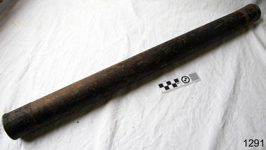 Flagstaff Hill Maritime Museum and Village
Container - Chart Case, ca 19th century
Black painted metal cylindrical container. Label attached at one end with inscription. "Flagstaff Hill c/ J Lindsay"This chart case is an example of maritime chart storage used in colonial times to protect charts and maps from the weather and to store them is an easily accessible was. Chart case, black painted metal cylindrical container with caps on both ends.flagstaff hill, warrnambool, shipwrecked-coast, flagstaff-hill, flagstaff-hill-maritime-museum, maritime-museum, shipwreck-coast, flagstaff-hill-maritime-village, chart case, navigation, chart storage -
 Victorian Aboriginal Corporation for Languages
Book, Rodger Elliot et al, Plant identikit : common native plants of the Grampians, 1998
This little book features detailed sketches of plants and includes a flowering seasons chart.Colour illustrations, mapsgrampians, plants -
University of Melbourne, Burnley Campus Archives
Document, Productivity Assessment Field Facility, 1982
Memo, notes, chart re productivity in Field Station. Refer to paper catalogue -
Whitehorse Historical Society Inc.
Book, Socio-demographic facts and figures about Nunawading, 1984
Detailed charts of figures, 1984 published by City of Nunawading Strategic Planning Unit.Detailed charts of figures, 1984 published by City of Nunawading Strategic Planning Unit.Detailed charts of figures, 1984 published by City of Nunawading Strategic Planning Unit.local government, city of nunawading, population, statistics, demography -
 Kew Historical Society Inc
Book, Libraries Board of South Australia, Narrative of a Survey of the Coasts of the Intertropical and Western Coasts of Australia performed between the Years 1818 and 1822 in two volumes (Vol.2), 1969
This two-volume work by Captain Phillip Parker King (1791–1856) was published in 1827, and describes the Royal Navy's 1817–22 surveying expedition to chart the coastal regions of Australia. King carried out the surveys in two successive ships, the Mermaid, which was declared unseaworthy in 1820, and the newly commissioned Bathurst. He worked on the charts, which were published by the Hydrographic Office, for two years after his return to England. He was made a Fellow of the Royal Society, and later undertook a similar surveying voyage, in which he was accompanied by Captain Fitzroy on the Beagle, around the coast of South America. The book is derived from the author's journal, and describes not only the voyages but also the towns and settlements of the region. Volume 2 continues the survey along the north and west coasts of Australia, and contains an appendix describing winds, currents, ports and islands.Australian Facsimile Editions No.30. 2 v. : illus., fold. charts, tables. non-fictionThis two-volume work by Captain Phillip Parker King (1791–1856) was published in 1827, and describes the Royal Navy's 1817–22 surveying expedition to chart the coastal regions of Australia. King carried out the surveys in two successive ships, the Mermaid, which was declared unseaworthy in 1820, and the newly commissioned Bathurst. He worked on the charts, which were published by the Hydrographic Office, for two years after his return to England. He was made a Fellow of the Royal Society, and later undertook a similar surveying voyage, in which he was accompanied by Captain Fitzroy on the Beagle, around the coast of South America. The book is derived from the author's journal, and describes not only the voyages but also the towns and settlements of the region. Volume 2 continues the survey along the north and west coasts of Australia, and contains an appendix describing winds, currents, ports and islands.philip parker king, natural history -- australia., australia -- description and travel -- to 1850. -
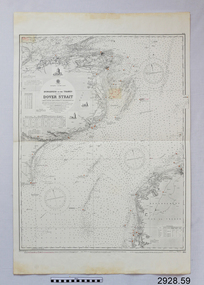 Flagstaff Hill Maritime Museum and Village
Document - Navigation Chart, Dungeness to the Thames and the Dover Strait
British Admiralty Navigation Chart - England - South Coast - Dungeness to the Thames and the Dover Straitwarrnambool, shipwrecked-coast, flagstaff-hill, flagstaff-hill-maritime-museum, maritime-museum, shipwreck-coast, flagstaff-hill-maritime-village, shipwrecked-artefact, navigation chart, british admiralty navigation chart, british admiralty, dungeness to the thames, dover strait -
Ringwood and District Historical Society
Plan, SGL Consulting Group Aust Pty, Maroondah Leisure Facilities Review / Strategic Plan 2010-2050, May-10
Prepared for the Maroondah City Council, Vol one - Executive Summary of the Maroondah Leisure Facilities Review Strategic Management Plan 2010-20508 A4 double sided printed documents with black and white photos, charts & text -
Federation University Historical Collection
Document - Document - Ballarat College of Advanced Education, Documents relating to Ballarat College of Advanced Education, Staffing, 1976; collected by E.J. Barker
E.J. Barker is a past principal of the School of Mines Ballarat and the Library at the Mt Helen Campus is named after him. Papers relate to the staffing structure at SMB and Ballarat College of Advanced Education, 1976. Various documents, charts, correspondence collected by E.J. Barker related to staffing at BCAE. Victoria e.j. barker, victoria institute of colleges, staffing, school of business studies, school of engineering, derek woolley, school of applied science, e phillips, civil and mining engineering, electrical engineering, mechanical engineering, chemistry, biology, geology, metallurgy, physics, malting and brewing, art, business studies, general studies, mathematics, librarianship, library, computer centre, counselling services, administrative staff, maintenance staff, cafeteria staff, student residence staff, resident nurse, bookshop staff, carpentry and joinery, bricklaying, electrical mechanics, machine shop, motor mechanics, panel beating, plumbing and sheetmetal, telecommunications, welding and blacksmithing, woolclassing, bcae academic staff, ballarat school of mines, ballarat college of advanced education -
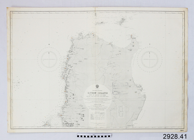 Flagstaff Hill Maritime Museum and Village
Document - Navigation Chart, Luzon Island : North of Latitude 16º 20' North
British Admiralty Navigation Chart - Luzon Island : North of Latitude 16º 20' Northwarrnambool, shipwrecked-coast, flagstaff-hill, flagstaff-hill-maritime-museum, maritime-museum, shipwreck-coast, flagstaff-hill-maritime-village, shipwrecked-artefact, navigation chart, british admiralty navigation chart, british admiralty, luzon island -
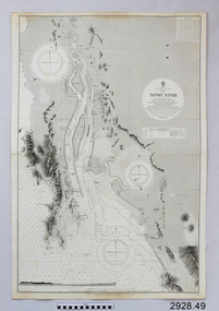 Flagstaff Hill Maritime Museum and Village
Document - Navigation Chart, Tavoy River
British Admiralty Navigation Chart - Bay of Bexgal - East Coast - Bruma - Tavoy Riverwarrnambool, shipwrecked-coast, flagstaff-hill, flagstaff-hill-maritime-museum, maritime-museum, shipwreck-coast, flagstaff-hill-maritime-village, shipwrecked-artefact, navigation chart, british admiralty navigation chart, british admiralty, tavoy river, bay of bexgal, bruma -
Glenelg Shire Council Cultural Collection
Document - Document - Conversion Chart, n.d
Port of Portland Authority Archivesport of portland archives -
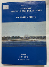 City of Moorabbin Historical Society (Operating the Box Cottage Museum)
Book, Syme, Marten A, Shipping arrivals and departures, Victorian ports : Volume 1, 1798-1845, 1984
"This book is dedicated to the seamen who supplied the physical link for trade and immigration in the development of the Colony".3 v. : ill., charts, map Maps on lining papers. Includes bibliography and index.non-fiction"This book is dedicated to the seamen who supplied the physical link for trade and immigration in the development of the Colony".ship register, seamen, immigration -
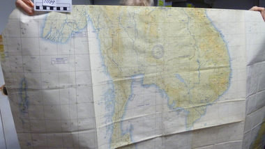 National Vietnam Veterans Museum (NVVM)
Map
Large USAF jet Navigation chart. Scale 1:2,000,000 of South China Seamap, navigation chart -
 Victorian Aboriginal Corporation for Languages
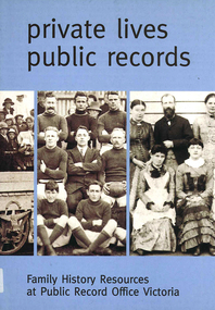
Book, Private lives, public records : family history resources at Public Record Office Victoria, 2003
Intended as a key resource for both first-time and experienced genealogists. It offers an introduction to the role, services and collection of Public Record Office Victoria, and a guide for family history researchers using the archives.colour photographs, b&w photographs, charts, letters, records, maps, plansgenealogy, local history, family history, public records, bibliographies, catalogues, victorian history -
 National Wool Museum
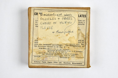
Container - Glass Plate Box, Criterion Plates Papers Films Ltd, 1900 - 1940
This item is part of a collection of six black and white glass lantern slides previously housed in this box. The slides and this box are part of a greater collection of around forty three black and white glass lantern slides, along with other photographs and photo albums related to this collection. This item is associated with the New South Wales Graziers Association world tour of merino sheep 1928/9. The slides were possibly used as supporting material in presentations made by J W Allen when on tour.Brown paper box with printed black text on a label adhered to top. Paper with hand written text is also stuck to top.top: [handwritten] DIAGRAMS OF WOOL / FOLLICLES + FIBRES. / CHART OF MERINO / FLEECE / + Micrographsnew south wales graziers association, travel, agriculture, j w allen, photography, glass lantern slide, sheep, breeding -
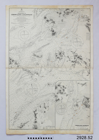 Flagstaff Hill Maritime Museum and Village
Document - Navigation Chart, Approaches to Chemulpho Anchorage
British Admiralty Navigation Chart - Yellow Sea - Korea East Coast - Approaches to Chemulpho Anchoragewarrnambool, shipwrecked-coast, flagstaff-hill, flagstaff-hill-maritime-museum, maritime-museum, shipwreck-coast, flagstaff-hill-maritime-village, shipwrecked-artefact, navigation chart, british admiralty navigation chart, british admiralty, approaches to chemulpho anchorage, korea