Showing 341 items
matching compass
-
 Hume City Civic Collection
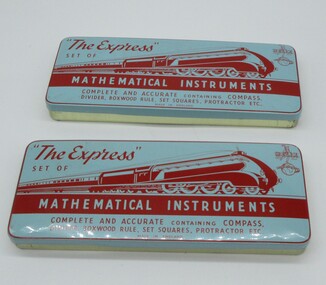
Education kit - Instruments, The Express
A set of mathematical instruments used in geometry and other more complicated drawing processes.A set of mathematical instruments in a tin. The tin has a blue lid with red and white lettering and the drawing of an express train. This is a Helix set of mathematical instruments comprising a compass, divider, boxwood ruler, set squares, protractor, eraser, pencil and blotter used in schools.education department, teaching, equipment, george evans collection -
 Flagstaff Hill Maritime Museum and Village
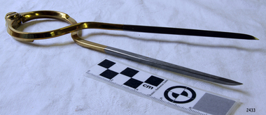
Functional object - Map Calipers/ Divider, Unknown
Compass, divider, and caliper are basically instruments that have two legs pivoted to each other at the top and are concerned with small-distance measurement or transfer. The compass and divider have straight legs; the caliper has curved legs. Dividers and Calipers were known to both the Greeks and Romans, though the caliper was uncommon. A divider with a circular sector, or wing, connecting the two legs was sketched in 1245, its modern counterpart is the wing divider with a thumbscrew clamp and screw for fine adjustment. Or the marine dividers used to measure the distance a vessel has travelled by transferring the vessels distance from a map with the divider and transferring that measurement to a marine ruler to mathematical calculate the distance.Item is believed to be a replica/ copy of a 19th century map calipers used in marine navigation to determine distance travelled. Item was probably purchased between 1972-1975 to add to the marine displays at Flagstaff Hill.Stainless steel dividers used in navigation charts. Top half is alloy plated. "W & HC" and "Made in England".flagstaff hill, warrnambool, shipwrecked-coast, flagstaff-hill, flagstaff-hill-maritime-museum, maritime-museum, shipwreck-coast, flagstaff-hill-maritime-village, stainless steel dividers, steel dividers, dividers -
 Federation University Historical Collection
Instrument - Surveyor's Instrument, Boxed Theodolite, c late 1880s
According to Max Clarke this item was used by the surveying classes at the Ballarat School of MinesA boxed (timber) theodolite with crossbars and full-length stadia wires. The theodolite can be mounted on a metal straightedge base. The box also contains a magnetic compass with two bubble levels, a plumbing folk, and 4 brass paper clips designed to suit a plan table. On box in black paint "A 1". Inside box lid is manufacturer's label and Stadia measurement zero reference calibration.ballarat school of mines, surveying equipment, gurley, max clarke, theodolite, stadia measurement, calibration, scientific instrument -
 Federation University Historical Collection
Instrument - Scientific Instrument, Miner's Dial, mid 1800s
A quadrant mounted telescope with crosshairs and external focussing, with longitudinal bubble level. Mountable on a magnetic compass plate with two bubble levels. Complete with dapered-spigot base plate and slot view attachments, Housed in a polished timber box. Inside the box are two labels -A label on the inside of the box " to the School of Mines and Industries, Ballarat" To (...) Hoadley, Esq, Principal, Footscray Technical school, Footscray WII" "Sluggish Needle, 9/4/3..." "still sluggisg 1966"mining, ballarat school of mines, surveying, archibald hoadley, scientific equipment, circumferential, scientific instruments -
 Warrnambool and District Historical Society Inc.
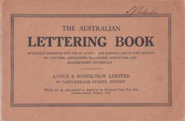
Booklet - Lettering Book, Halstead Press Pty Ltd, The Australian Lettering Book, 1945
Author Herbert Newell. Alphabets of varied fonts, headings, flourishes, plans, numerals, sketch maps, scrolls, shading, common errors, compass points. Especially designed for use in Australian Schools, offices of Lawyers, Architects, Surveyors, Engineers, Engravers, and Draughtsmen. Table of contentsThe author is a teacher of show card and ticket writing at Sydney Technical College. Book used by many students and offices. Note by the publishers provides standards for the correct form of the characters. Light brown light card cover with black ink font and border patterns. 32 Cream pages with black ink. Two staples. Hand written name on top of outline black border S. R Coleston. Price 3/9warrnambool, lettering book, angus & robertson limited, s.r. coleston, herbert newell -
 Stratford and District Historical Society
Theodolite
This theodolite was used by `Mr Dawson' (presumably William Tennant Dawson c.1820-1873) who `surveyed much of the area around and beyond Stratford'. It was damaged by the fire which burnt the original Roseneath home in 1921, when the Macleods were in residence. (Mrs W.T. Dawson was a Macleod). One little boy aged 3 years was given the job of saving everything on the kitchen table when the fire started at breakfast time. The theodolite was possibly in use by Dawson when he laid out St Kilda Road.This theodoite consists of a bottom plate, which is damaged and has melted metal. This rises to a ball joint, on which is pivoted another plate on which were housed four screws, of which three remain, to adjust the level. Above this is another plate, with compass markings and melted glass."Troughton and Simm's/London" in fine engraving on upper plate.surveyors, instruments -
 National Vietnam Veterans Museum (NVVM)
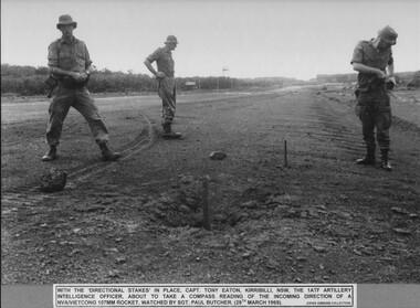
Photograph - B&W image, Checking Impact Area 3
A black and white photograph of - With the "directional stakes" in place, Capt Tony Eaton, Kirribilli, NSW, the 1st ATF Artillery Intelligence Officer about to take a compass reading of the incoming direction of a NVA/VietCong 107mm rocket, watched by Sgt Paul butcher (29th march 1969)photograph, capt tony eaton, 107mm rocket, 1st atf base, artillery intelligence officer, sgt paul butcher, nva/vc, luscombe airfield, gibbons collection catalogue -
 Queenscliffe Maritime Museum
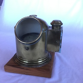
Instrument - Binnacle
The binnacle was originally from a lifeboat of the tug 'Melbourne' previously 'Howard Smith'. When the vessel sank at Gellibrand [Williamstown], the binnacle was under water for about one month. The lifeboat was later cut loose from the wreck by a salvage crew [as told by the donor].A good example of a small binnacle and compass as used on a lifeboat from the 1950s.Binnacle, brass with wick light mounted on timberbinnacle, compass, tug boat, 'melbourne', 'howard smith' -
 Glenelg Shire Council Cultural Collection
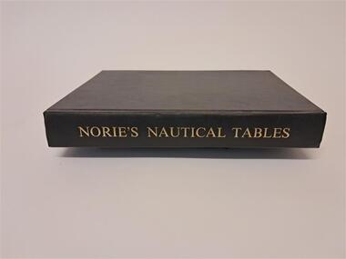
Book - Norie's Nautical Tables, Imray, Laurie, Norie & Wilson Ltd, 1981
This book contains nautical tables such as the Suns Total Correction, Table of the angles of the Mariner's Compass, Traverse Table, Logs. of Trig. Functions, Haversines, Hour angle etc.Black covered hard cover book. 546 pages plus an index.non-fictionThis book contains nautical tables such as the Suns Total Correction, Table of the angles of the Mariner's Compass, Traverse Table, Logs. of Trig. Functions, Haversines, Hour angle etc.nautical, angles, compass, logs, functions -
 Flagstaff Hill Maritime Museum and Village
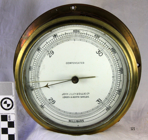
Instrument - Barometer, 1952
Mr John Wilson Gillie was born on the 31st of March 1864. On the 31st of July 1880 he was apprenticed for four years to J.J. Wilson and Sons, Nautical Instrument Makers of Sunderland. Following the apprenticeship he spent six months to a year as an ‘improver’ in Glasgow, and then started a new company ‘Wilson and Gillie’ in North Shields. At this time sail had just given way to steam and wooden ships to steel, and the railways were competing with colliers for the carrying of coal from the North East of England to London and the South. In 1858 only seven out of 44 shipyards on the Tyne were using iron, but by 1862 there were ten, employing around 4,000 men. These changes had a significant effect on nautical instrument manufacturers, as the magnetic compass for a wooden sailing vessel was very simple and required little in the way of compensation. For steel vessels much more was required and this was a period of great development, both in the compass bowl and the binnacle in which it was housed. In 1870 Sir William Thomson (later Lord Kelvin) designed his dry card standard compass, which completely replaced all previous designs. Wilson and Gillie started as agents for the Thomson compass, but later J.W. Gillie, using similar principles, redesigned the compass suspension and patented the ‘UNIT’ standard compass. It became popular with local shipowners and shipbuilders. In 1910 the firm of John Lilley and Son (which had been established in London in 1812), found themselves in financial difficulties and were saved with the help of John Wilson Gillie, who established, on the 8th of August 1911, a new firm of John Lilley and Son Limited. John Lilley and Son had been the sole London agents for Sir William Thomson, a very enviable position during this period, when the Thomson compass led the field. Unfortunately, Mr. Lilley had quarreled with the Glasgow company, who withdrew the agency and established their own branch in London (later to become Kelvin White and Hutton). On November 7th 1913, the firm of John Lilley and Son Limited of London amalgamated with Wilson and Gillie of North Shields, and after this date instruments manufactured by the two companies bore the name John Lilley and Son Limited of London and North Shields. During the 1930s many of the London nautical instrument makers were in difficulties, including John Lilley and Son Limited and Reynolds and Son, Dobbie and Clyde Limited, and Mr. J.W. Gillie arranged an amalgamation between these two companies. The new firm became Lilley and Reynolds Limited. In 1943, with estate duties in mind, the North Shields company was reconstituted and took the name of John Lilley and Gillie Limited, although the shareholders, directors and personnel remained unchanged In the early 1970s Lilley and Gillie developed close links with Observator in Rotterdam, who manufactured one of the first fully reliable transmitting magnetic compass systems. The Observator shareholders, Holland America Line, bought the share capital of John Lilley and Gillie Limited., but retained all the personnel and the directors. Tug Melbourne: The barometer was salvaged from a 496-ton tug that had been built in 1952 and had sunk in Port Philip Bay on the 9th of August 1972 after a collision with the SS Nieuw Holland, in 1973 it had been raised and scraped at this time the barometer was salvaged. The tug had been renamed from the Howard Smith to the “Melbourne” after the Adelaide Steamship Co was taken over by Howard Smith& Co, who were heavily involved in towage, salvage and the stevedoring industries in 1961.The significance is that the item was on a vessel that was evolved in a serious collision in Port Philip Bay in 1972. It is linked with the activities of the Port at that time and helps to form a picture of what the maritime industries that operated from Port Melbourne were like and the activities that stevedore and towage companies underwent.Ship Barometer, in brass caseInscribed "Compensated" , "John Lilley & Gillie Ltd London & North Shields." and "Millibars".flagstaff hill, warrnambool, shipwrecked coast, flagstaff hill maritime museum, maritime museum, shipwreck coast, flagstaff hill maritime village, great ocean road, barometer, ship's barometer, weather instrument, john lilley & gillie ltd, shipwreck artefact, the tigboat melbourne, north shields, howard smith, the melbourne, salvage -
 Bendigo Historical Society Inc.
Map - MINING REPORTS - MAP OF COLLMANN AND TACCHI SHAFT
Hand drawn map showing the Collmann and Tacchi Shaft with No 17 Crosscut with the distances in feet and inches and the compass bearing of each leg. It is beside Mt Korong Road, near Dowding Street. Some boundary lines are drawn. Also on the map is Lansell's C and T across the road.map, bendigo, goldfields, mining reports, map of collmann and tachi shaft, collmann and tacchi shaft, lansell's c and t -
 National Vietnam Veterans Museum (NVVM)
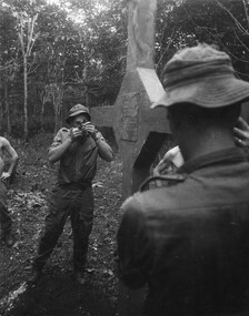
Photograph, Gibbons, Denis, Long Tan Cross Dedication 1
Denis Gibbons (1937 – 2011) Trained with the Australian Army, before travelling to Vietnam in January 1966, Denis stayed with the 1st Australian Task Force in Nui Dat working as a photographer. For almost five years Gibbons toured with nine Australian infantry battalions, posting compelling war images from within many combat zones before being flown out in late November 1970 after sustaining injuries. The images held within the National Vietnam Veterans Museum make up the Gibbons Collection. A black and white photograph of Long Tan, Phuoc Tuy Province, South Vietnam, 18/08/1969. A digger from 6th Battalion/New Zealand (ANZAC) Royal Australian Regiment, sites in the cross of remembrance using a compass whilst facing directly at the area of the bloody battle.photograph, long tan cross, phuoc tuy province, 6th battalion, 4rar nz, royal australian regiment, gibbons collection catalogue, denis gibbons, photographer, vietnam war, digger, long tan cross dedication -
 Bendigo Historical Society Inc.
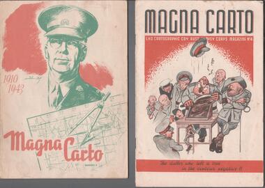
Magazine - THE BROOK AND ANDERSON FORTUNA COLLECTION: MAGNA CARTO MAGAZINE
Two copies of the Magna Carto Magazine of the Australian Survey corps. Issue two and four. Issue two has a drawing of a soldier and a map and compass with the words 1910-1943 on the cover. Issue four has a group of soldiers around a table with the words ''the duffer who left a tree in the contour negative!!''.military, world war 2 -
 Vision Australia
Functional object - Object, Royal National Institute for the Blind, Tactile yellow ruler
30 cm tactile yellow ruler with black marking every 5 centimeters with raised markings, has two different edges - straight and notched. The straight edge can be used for measuring and drawing, and the notched edge designed to help place pins when creating charts and graphs or using a compass. There are non-slip pads on the back of the ruler. 1 yellow ruler with black large print numbers and black measurement indicatorsRNIB LT21 (on back)assistive devices, royal national institute for the blind -
 Ballarat RSL Sub-Branch Inc.
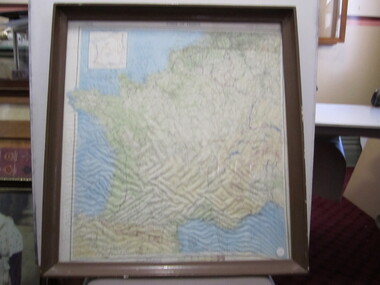
Photograph - "Zones of France"
On back - "R.A.F. aircrew escape map in World War II, printed on silk, carried in trousers knee pocket, and used with compass built into brass button (left-hand thread). The object was to set the aviator in the right direction for nephoto/pictures, ballarat rsl, ballarat -
City of Kingston
Photograph - Black and white, 3 March 1954
Cheltenham and Moorabbin are suburbs within the City of Kingston that were originally established as rural market gardening communities The area is bordered by Highett and Mentone. The market gardens, farms and paddocks have gradually been sub-divided into housing and industrial estates. Highett is developed with residential homes but was also the site of major facilities such as the Highett Gas Works. This aerial image covers a diverse section of the City of Kingston, taking in the suburbs of Moorabbin, Cheltenham, Highett and Mentone Residential housing development is prominent along the Frankston Railway line and the area still retains extensive market gardens and paddocks yet to be converted to a large industrial and commercial zone.Aerial photograph of Mentone, Cheltenham and Moorabbin within the City of Kingston. The area depicted in this 1954 aerial view includes Warrigal Road and Centre Dandenong Road intersection (top left); Charman Road, Patty Street, Bourke Street, Collins Street Mentone (top right); Keys Road Moorabbin (bottom left); Bay Road, Cheltenham (bottom right), Friendship Square, Cheltenham Park, Victoria Golf Club and Jack Barker Oval are visible. Nepean Highway and the Frankston railway line run centrally through the image. Highett Gasworks is also evident.White handwriting and type [indecipherable]. White image of clockface White image of compass White type 42956 Black handwriting 3/3/54 Williams [indecipherable] Black pencil: S [arrow] Black ink: 3/3/1954cheltenham, moorabbin, mentone, highett, market gardens -
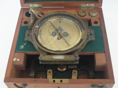
 Federation University Historical Collection
Instrument - Miner's Dial, c early 1900s
A miner's dial was used by surveyors to determine the direction of underground tunnels and roadways. The inclinometer allowed measurement of the angles at which mine tunnels descend into the ground.A rare miner's dial in a hinged timber box.This surveying instrument consists of a theodolite monsblr on a magnetic compass, which sits on the vertical tapered spigot of a base plate. Fits tripod catalogued item 4133. Inside the box lid is the supplier's label - W. Travill (successor to D. Esdale) of 146 Little Collins Street, Melbournemining, ballarat school of mines, surverying, scientific instruments, scientific objects -
Tatura Irrigation & Wartime Camps Museum
Book - text, Internees at camp 1 Tatura, 1942
Text book on navigation compiled in Camp 1 Tatura by interneesHard sand coloured covered stitched text book of 208 pages. Separate dust cover and errata section/insert. Dust cover has hand painted illustration on front of sea/sky landscape, Ship, compass like star and title at top. Errata. Consists of 2 single sheets folded forming 8 pages.as abovekeuchenmeeister, fleth -
 Tennis Australia
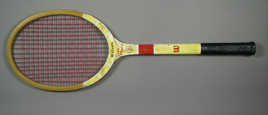
Racquet, Circa 1955
A Wilson Famous Player Model tennis racquet. Wilson logo features across base of head. Model name with a compass device feature on the throat. 'W' trademark features at the base of the shaft. Leather handle grip features quatrefoil perforations. Materials: Wood, Nylon, Leather, Adhesive tape, Paint, Glue, Lacquer, Metal, Ink, Ribbontennis -
 Flagstaff Hill Maritime Museum and Village
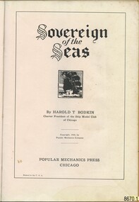
Book - "Sovereign of the Seas" book or manual for the ship model hobby enthusiast, Harold T. Bodkin, 1933, "Sovereign of the Seas", Popular Mechanics Press
Jim (James Bernard) Williams, who was the owner of this manual, was a long-time resident of Warrnambool having the opportunity to work at two notable historical businesses of the town. The first, Cramond & Dickson a drapier store established around 1852-1855 and which remained a store that traded under the same name for the longest in Victoria, before it closed its doors in 1974. The second business was Fletcher Jones a highly successful textile and clothing Australian business. Some of Jim’s spare time was devoted to the model ship making which would conjure up many fascinating stories of maritime history. In addition to Jim witnessing the tail end of ships at port in Warrnambool, his "father was as sea captain and operated his vessel in Bass Strait coastal trade between Tasmania and Victoria". The intricately detailed model made by Jim is full of precise detail. The manual and the blueprints held by Flagstaff Hill Maritime Village also reflect the intricate process and devotion to the task completed by Jim. The history of the shipwreck and maritime stories of the Victorian Southwest coast surrounding Warrnambool would have continued to inspire his passion. Three photos of the model and Jim, like the photo of Harold T. Bodkin in the manual, attest to the enthusiasm and enjoyment that was gained by him through this hobby. The manual opens to a photo of “Mr. Harold T. Bodkin adding finishing touches to model of the “Sovereign of the Seas”. The “Forward to Reader” which is on the next page is written by “E. R. HAAN, Technical Editor, Popular Mechanics Magazine. The forward explains the methodology used to achieve the fine detail that is part of the body of the model, by “applying imitation carvings”, and is cited as “a museum type of model”. The following page “Blueprints and Craftmats on the ‘Sovereign of the Seas’” discusses the availability of a set of blueprints to purchase separately. Followed by a description of the moulding process for the “miniature carvings”. “Historical Notes of Interest on the “Sovereign of the Seas (1637)” follow on the next page. The manual is divided into the following parts from pages 8 to 71: “Part I – Shaping the Hull/Part II – The Rudder, Quarter Galleries and Gunports/Part III Wales, Gunport Covers and Initial Ornamentation/Part V – Beakhead Decoration, Bulkhead and Rails, Etc./Part VI Carvings, Lanterns, Knights, Bitts and Painting/Part VII – Details of Mast Construction/Part VIII – Standing Rigging/Part IX – Running Rigging and Final Details. All of these instructions include photographs and detailed graphs. Then instructions on “How to Read and Use Ship-Model Drawings”, “The Shop-Model Maker’s Tools”, and “Simplified Ship-in-a-Bottle”. This is finished off with “Helpful Hints….” And numerous pages of advertising. Some adverts include aids for completing the “Sovereign of the Seas” model. Part I uses blue and black ink to illustrate a dramatic picture of the “Sovereign”, otherwise all print is in black ink on buff paper. This book in significant to the collection as it was donated along with other tools and blueprints which have been used by the donor of the "Sovereign of the Seas" model ship. It also connects with the wider community in that it is related to historical maritime interest and the donor, Jim Williams is also connected to other significant retail and manufacturing businesses of the past in Warrnambool. This manual has been covered with brown paper, including an extra strip for the spine. The front has a watermark at the top middle, some pencilled compass circles segmented into eight parts across the area and a small amount of script writing. The back also has the same type of compass circles and some other small shapes. There are also grease marks. The cover has a patina adding to variations of colour to the paper indicative of the book being handled often. The title page reads “Sovereign of the Seas” in an Old English font. This is followed by a lithograph print around 1 inch square of a ship at full sale. By HAROLD T. BODKIN/Charter President of the Ship Model Club of Chicago/Copyright, 1933, By Popular Mechanics Company/POPULAR MECHANICS PRESS/CHICAGO/Printed in the U.S.A. By HAROLD T. BODKIN/Charter President of the Ship Model Club of Chicago/Copyright, 1933, By Popular Mechanics Company/POPULAR MECHANICS PRESS/CHICAGO/Printed in the U.S.A.flagstaff hill, warrnambool, shipwrecked coast, flagstaff hill maritime museum, maritime museum, shipwreck coast, flagstaff hill maritime village, great ocean road, model ship, vessel sovereign of the seas, jim williams, james bernard williams, the forth tasmania, freda williams, heather williams, phyllis bowditch, fletcher jones staff 1936, 17th century sailing ship, cramond and dickson, sovereign of the seas, royal sovereign, sovereign, charles 1, fletcher jones, warrnambool breakwater -
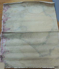 Flagstaff Hill Maritime Museum and Village
Document - Chart, Admiralty Office, Port Phillip, 1899
Accurate charts were imperative for sea farers to sail their vessels safely from one side of the world to another. The British Admiralty published many charts and updated them frequently. Specialists were employed to gather information such as depth soundings to give the navigator as many helps as possible. At regular intervals the charts had to be updated with the amount of adjustment needed to a compass to allow for magnetic variation.This chart is significant for its association with incoming and outgoin ships for trade and passengers in the late 19th century.Admiralty Chart of Port Phillip, Victoria, South Coast of Australia. It shows navigation buoys, lighthouses, tides and money other details. It was surveyed by Commander Henry L. Cox R.N. in 1864. Published by Admiralty August 19th 1865. Corrections were made by Staff Commander E.J. Stanley R.N. in 1874. The West Channel was surveyed b J.B. Mason , Engineer, in 1899. Published and cartographed in Admiralty, London, England in 1897, supervised by Capt G H Richards R N Hydrographer. Chart was updated in 1899. Sold by W D Potter Agent for Admiralty Charts 145 minorities.Printed: "Port Phillip" "Australia - South Coast, Victoria"flagstaff hill, warrnambool, maritime-museum, flagstaff hill maritime museum & village, shipwreck coast, chart, australia, south coast, port phillip, admiralty, 1899, navigation, cartography, cartographer -
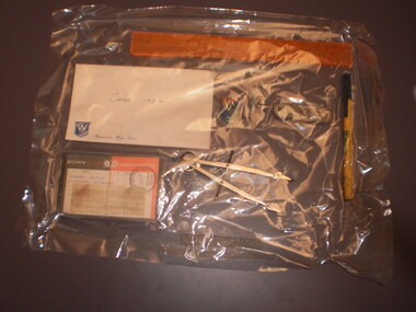 Wangaratta High School
Assorted Stationary, 0982
A collection of stationary including a metal compass, a yellow ballpoint pen, two WHS badges, one of the school logo, the other designating a member of the SRC, a cassette tape labelled Charles Perkins Monday Conference, an orange flexible ruler and an unopened letter labelled Cairns 1984. This item is was a part of a time capsule buried in Wangaratta High School grounds in 1984 -
Glen Eira Historical Society
Book - Church of Christ, 40 Toolambool Road, Carnegie
Three items about Church of Christ: 1/ A twenty page booklet on the beginnings and history of one hundred years of the Church of Christ. 2/ Photocopied pages taken from the above book with furniture donations and a list of ministers and statistics. 3/ A newspaper article, dated 31/08/2010, showing local pastors from the Glen Eira Compass Church, mentioning that Carnegie Church of Christ received $8,000.church of christ, toolambool road, carnegie, ward clive l, blair margaret, boak russell, clayton road, north road, stewart family, carr family, robert family, boak family, paul mr., proctor mr., crisp mrs., barrett family, murrumbeena, boak allen-senior, melbourne street, newhan family, arnott family, eaton family, neerim road, emily street, railway avenue, murrumbeena road, boak peter, barrett j.g, dickens p.a, wilson w, newham c, wilson a.p, cambridge w.g, luke w.g, blair sister, ryall e.f, gracie thomas, kelson mr, kestle ms, christian education centre, kindergarten hall, blackwood street, manses, hall norma, nelson may, compass church -
 Bacchus Marsh & District Historical Society
Map, Plan of the property of Messers Atkins and Clarke to be sold at the Mansion, Bacchus Marsh 19th April 1856. Copy 1
This plan of land allotments for sale indicates the property once owned by the Bacchus family in and around the township area of Bacchus Marsh. The Bacchus family sold their property in Bacchus Marsh to John Atkins and Robert Nalder Clarke in March 1851. Atkins and Clarke kept the property for a number of years until April 1856 when these allotments were put up for sale.This plan is almost identical to another copy held by the Bacchus Marsh and District Historical Society, VC Record 452, BMDHS collection). This plan, VC Record 707 Copy 1, contains a little more detail overall than VC Record 452 Copy 2, such as who did the survey work for the plan (R.C. Bagot) and who the selling agents were, (W.M. Tennent), and on the right side of the plan near the Lerderderg River is indicated the general area for a second parcel of land from this sale which is to be sold. There is also a compass illustration indicating north and south compass points.This is a very early land sales plan for the township of Bacchus Marsh and it therefore provides some clues as to how the early urban development of the township took place. Upon seeing the map in 1911 Bacchus Marsh Express newspaper editor Christopher Crisp wrote "The sale appears to have created the present township, which had a nucleus in earlier times further east", Express, 30 September, 1911, page 3.A single page paper plan showing allotments of land for sale. The subdivided land shown was owned by John Atkins and Robert Nalder Clarke, but previously owned by the Bacchus Family and was in and around their Manor House (Mansion) property in Bacchus Marsh.There are 5 portions of land further divided into numerous small portions. The land for sale is bounded by the present day streets of Main Street, Young Street, McFarland Street, Morton Streets, Crook Street, and part of the eastern section extends to the Lerderderg River. Scale: 8 chains to 1 inch The plan is pasted into a bound volume containing 76 maps or plans in total. BMDHS Loc: AR/B12/S4 Bacchus Marsh Township and Nearby Districts Maps Volume In-house Digital copies: BMDHS, Computer Network: Maps\Bacchus Marsh Township and Nearby Districts Maps VolumeHeading: Plan of the first portion of land. The property of Messers Atkins and Clarke situate at Bacchus Marsh. To be sold by W.M. Tennent & Co. at the Mansion on the Ground on Saturday the 19th April 1856. Below heading: Jas Ferguson, Lithographer On upper right side: Subdivided by R.C. Bagot London and Liverpool Chambers, Melbourne. 'Thos Taubman'. Post Office Stamp: BACCHUS MARSH VICTORIA MY 6, 63bacchus marsh victoria maps, bacchus family, land sales, manor house bacchus marsh -
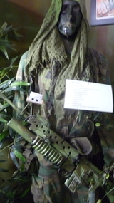 National Vietnam Veterans Museum (NVVM)
Uniform - Uniform, SAS, Mannequin of SAS soldier fitted out for patrol
Mannequin of SAS soldier fitted out for patrol wearing - US Army camo uniform, replica armalite rifle, replica 40mm grenade launcher, spare 40mm replica grenades, ammo pouches, water bladder on chest, M26 grenade, compass pouch, smoke cannister, bayonet, water bottles, , backpack with rations, sleeping gear, sweat rag on head, GP boots.sas, sas soldier, mannequin -
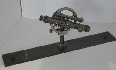
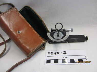 Wannon Water
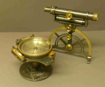
Clinometre / Abney Level, E. R. Watts & Son, Clinometre
Abney Level / Clinometer is an accurate surveying tool used to measure degrees, percent of grade and topographic elevation. Used for surveying pipe lines.Instrument which consists of a fixed sighting tube, a movable spirit level connected to a pointing arm which turns and pivots. Adjustment knob/screw on top turns to rotate the compass indicator and bubble level. Arched scale graduated 0 to 90 degrees in both directions. Clinometer is housed in a brown leather case with a long leather strap for carrying around the neck.Watts London / No 70131 / Made in England -
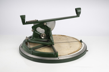 Department of Energy, Environment and Climate Action
Fire Finder
Victoria once had well over one hundred fire lookouts and firetowers. Fire lookouts, or observation posts, were often just a clearing on a hill or a vantage point, whereas firetowers were definite structures. Many were established by the Forests Commission Victoria (FCV) in the 1920s, but the network was expanded rapidly in response to recommendations of the Stretton Royal Commission after the 1939 Black Friday bushfires. When a fire or smoke was spotted from the tower a bearing was taken with the alidade and radioed or telephoned into the district office. It was then cross referenced with bearings from other towers on a large wall map to give a "fix" on the fire location. Alidades and telescopes were used in the post war period but were replaced with a much simpler map table and reference string suspended from the centre of the tower cabin. This "Fire Finder" was used in Canadian fire towers to identify the location of wildfires. The unique design was first developed by the British Columbia Forest Service (BCFS) in the early 1950s. Close examination of the map indicates that this particular Fire Finder may have been once used at Bluejoint Mountain lookout in Granby Provincial Park. This Fire Finder was a gift to Barry (Rocky) Marsden from the British Columbia Forest Service in the late 1980s in recognition of the close relationships that had been forged with the staff at the Altona Workshops over many decades. Fire Finders were originally painted black but this one was repainted green after it arrived at Altona. The BC Forest Service had a large facility where they manufactured Fire Finders and many other items of equipment, but in the 1980s it was shut down. Heavy cast iron circular object with a paper topographic map mounted on it. The metal dial and ruler works similar to a compass. The sight tube is used to determine the bearing and elevation of the fire on the map. This Fire Finder also sometimes known as an Alidade. Its a different design from the Osborne Fire Finder widely used in North American fire lookouts from the 1920s. British Columbia Forest Service. Model 62A. Serial Number 6308.bushfire -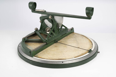
 Melbourne Tram Museum
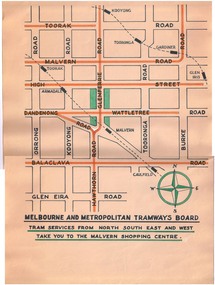
Poster, Melbourne & Metropolitan Tramways Board (MMTB), Malvern Shopping Centre, 1950's?
Poster titled "Melbourne and Metropolitan Tramways Board - Tram services from North South East and West take you to the Malvern Shopping Centre" Prepared on a Dyeline drawing base and then hand coloured using a draftsman's wash in red for tram lines and green for the shopping centre. Shows the various main roads, tram lines, and rail lines. Has a compass drawn on it. No date - presumed 1950'sctrams, tramways, malvern, glenferrie rd, shoppers -
 Flagstaff Hill Maritime Museum and Village
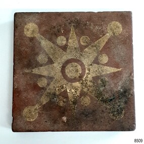
Ceramic - Floor Tile, Maw & Co, 1862-1869
The floor tile is one of a group of artefacts in the McCulloch Collection that were recovered from the shipwreck Victoria Tower and were donated together. The tile could have been from the ship's cargo or amongst a ship’s fittings. The inscription on the tile is for Maw & Co makers of earthenware encaustic and geometric floor tiles since 1850, when George Maw and his brother Arthur began their first factory in Worcester. In 1862 the company moved to Broseley, Shropshire. The object is now one of the shipwreck artefacts in Flagstaff Hill’s Mc Culloch Collection, which includes items recovered from the wrecks of the Victoria Tower (wrecked in 1869) and Loch Ard (wrecked in 1878). They were salvaged by a diver in the early 1970s from the southwest coast of Victoria. Advanced marine technology had enabled divers to explore the depths of the ocean and gather its treasures before protective legislation was introduced by the Government. The artefacts were donated to Queensland’s Department of Environment and Heritage Protection (EHP) by a passionate shipwreck lover and their locations were verified by Bruce McCulloch. In 2017 the Department repatriated them to Flagstaff Hill where they joined our vast collection of artefacts from Victoria’s Shipwreck Coast. The Victoria Tower: - The three-masted iron clipper ship was built in 1869 in Liverpool, England, as a passenger and cargo ship for the Australian trade. She was named after one of the two towers of the British Houses of Parliament and owned by the White Star line. The Victoria Tower sailed under the command of Captain Kerr from Liverpool towards Melbourne on her maiden voyage. She carried 34 passengers and 16 crew plus a general cargo including bottled beer, slates, iron pipes and hardware. She was almost at her destination when she was wrecked on 17th October 1869 at Point Impossible, west of Thompsons Creek, Breamlea. The shipwreck is a very popular diving site. The artefact has now been repatriated to Victoria and is located at Flagstaff Hill Maritime Village. The artefact is an example of cargo or personal items on board a ship in 1869. It provides a reference point for classifying and dating similar items. The artefact is significant for its association with the clipper ship Victoria Tower, which is listed on the Victorian Heritage Register as S698. The Victoria Tower is recorded as the most intact historic shipwreck accessible between Point Lonsdale and Cape Otway. The Victoria Tower is one of only seven shipwrecks in Victoria that have had more than 100 objects recovered from them reported as a result of the Commonwealth Amnesty held in 1993-94.Ceramic tile, square, with star or compass design.Brown tile has cream design of i-pointed star with a circle in the centre and between, and on the end of, each point. The side profile of the tile shows the division between the top layer and the base, with a groove between the two. The tile was made by MAW & Co. of Broseley, England. The back of the tile has parallel ridges and is embossed with an inscription. It was recovered from the wrecked ship Victoria Tower. Inscribed "MAW & CO BROSELEY" flagstaff hill, warrnambool, maritime village, maritime museum, flagstaff hill maritime museum and village, shipwreck coast, great ocean road, shipwreck artefact, wreck dive, mcculloch collection, bruce mcculloch, white star line, victorian heritage register, clipper ship, victoria tower, captain kerr, shipwreck victoria tower, migrant ship 1869, cargo ship 1869, iron clipper, british clipper ship, 1869, cargo imported to australia, tile, floor tile, ceramic tile, compass pattern, star pattern, flooring