Showing 1512 items matching "country road"
-
 Eltham District Historical Society Inc
Photograph, Russell Yeoman, Fitzsimons Lane Bridge over Yarra River between Eltham and Templestowe, c.1970, 1970c
... , Templestowe. In 1955 the Country Roads Board (CRB) produced survey..., Templestowe. In 1955 the Country Roads Board (CRB) produced survey ...The bridge over the Yarra River was initially opened September 22nd, 1961. Newspaper reports at the time of opening stated it linked Bolton Street, Eltham, with Fitzsimons Lane, Templestowe. In 1955 the Country Roads Board (CRB) produced survey plans that showed proposed land acquisition for the future bridge and road approaches. The 1955 plan shows that it was proposed to connect Fitzsimons Lane with Bolton Street in Eltham by a diagonal road across the river. The road connection would then continue along Bolton Street to Main Road. Prior to construction of the bridge the CRB modified the proposal significantly so that there was a new road parallel with Bolton Street and then curving to join Main Road at what was then its intersection with Old Eltham Road. This involved significantly more land acquisition and altered the pattern of land subdivision through this corridor. Initially the new road was just a single two-way carriageway as it would have required a significant widening of the cutting on the Shire of Eltham side of the river. The road was officially un-named but was known locally as the Eltham-Templestowe Road. The 1966 Melway street directory and other 1960s editions also listed the road as the Eltham-Templestowe Road. In December 1970, Eltham Shire Council, in pursuance of the provisions of the Local Government Act, named it Templestowe Road. The road was renamed Fitzsimons Lane around 1984 in conformity with the section south of the river. In 1991 a new bridge was built to the west of the original bridge. Fitzsimons Lane was widened to four traffic lanes although on the Eltham side this was done within the limits of the existing cutting. NEW BRIDGE STARTS THEM EXPLORING Without any fanfares, Country Roads Board workmen on Friday afternoon put the finishing touches to the approaches, removed the barricades, and let the traffic roll over the new Yarra bridge linking Bolton Street, Eltham, with Fitzsimons Lane, Templestowe. Over the week-end many “bridge watchers” who were making one of their periodic inspections of the progress on the new bridge found to their surprise that they could drive over it, so that people who had gone for a run out to Eltham suddenly found themselves wandering through Templestowe and Doncaster. By Monday the word of the bridge’s opening had got around sufficiently for many regular travellers to the city from Eltham and beyond to vary the monotony by going to town via Templestowe and Kew instead of through Heidelberg. They were surprised at the distances – about 3 ½ miles from Eltham to Templestowe, 6 miles from Eltham Shire hall to the Lower Heidelberg Road-Banksia Street intersection. NEW NEIGHBOURS For people on both sides of the river, the new bridge has turned distant friends into near neighbours. A Greensborough man on Sunday took 35 minutes to reach the home of a friend in East Doncaster, but the return trip over the new bridge took only 17 minutes. It will be some time yet before most people work out the possibilities in shorter and quicker trips form the north-eastern areas to the eastern and south-eastern suburbs. The coming of the warmer months will soon teach many, though the short cuts to Peninsular beaches and eastern suburban drive-ins. And before very long it is likely there will be a Tramways bus running from Templestowe to Eltham station. NEW BRIDGE STARTS THEM EXPLORING (1961, September 27). The Diamond Valley News (News clipping held in SEA_74-1_047) The previously un-named road between Main Road and Yarra River, Eltham South, east of Bolton Street was named Templestowe Road, December 15, 1970 NAMING OF STREETS AND ROADS. (1970, December 15). The Diamond Valley News (News clipping held in SEA_74-2_022)Roll of 35mm black and white negative film, 4 of 7 stripsIlford HP4bridge, bridges, fitzsimons lane bridge, infrastructure, shire of eltham infrastructure, yarra river -
 Eltham District Historical Society Inc
Photograph, Fitzsimons Lane Bridge over Yarra River between Eltham and Templestowe, c.1966, 1966c
... , Templestowe. In 1955 the Country Roads Board (CRB) produced survey..., Templestowe. In 1955 the Country Roads Board (CRB) produced survey ...The bridge over the Yarra River was initially opened September 22nd, 1961. Newspaper reports at the time of opening stated it linked Bolton Street, Eltham, with Fitzsimons Lane, Templestowe. In 1955 the Country Roads Board (CRB) produced survey plans that showed proposed land acquisition for the future bridge and road approaches. The 1955 plan shows that it was proposed to connect Fitzsimons Lane with Bolton Street in Eltham by a diagonal road across the river. The road connection would then continue along Bolton Street to Main Road. Prior to construction of the bridge the CRB modified the proposal significantly so that there was a new road parallel with Bolton Street and then curving to join Main Road at what was then its intersection with Old Eltham Road. This involved significantly more land acquisition and altered the pattern of land subdivision through this corridor. Initially the new road was just a single two-way carriageway as it would have required a significant widening of the cutting on the Shire of Eltham side of the river. The road was officially un-named but was known locally as the Eltham-Templestowe Road. The 1966 Melway street directory and other 1960s editions also listed the road as the Eltham-Templestowe Road. In December 1970, Eltham Shire Council, in pursuance of the provisions of the Local Government Act, named it Templestowe Road. The road was renamed Fitzsimons Lane around 1984 in conformity with the section south of the river. In 1991 a new bridge was built to the west of the original bridge. Fitzsimons Lane was widened to four traffic lanes although on the Eltham side this was done within the limits of the existing cutting. NEW BRIDGE STARTS THEM EXPLORING Without any fanfares, Country Roads Board workmen on Friday afternoon put the finishing touches to the approaches, removed the barricades, and let the traffic roll over the new Yarra bridge linking Bolton Street, Eltham, with Fitzsimons Lane, Templestowe. Over the week-end many “bridge watchers” who were making one of their periodic inspections of the progress on the new bridge found to their surprise that they could drive over it, so that people who had gone for a run out to Eltham suddenly found themselves wandering through Templestowe and Doncaster. By Monday the word of the bridge’s opening had got around sufficiently for many regular travellers to the city from Eltham and beyond to vary the monotony by going to town via Templestowe and Kew instead of through Heidelberg. They were surprised at the distances – about 3 ½ miles from Eltham to Templestowe, 6 miles from Eltham Shire hall to the Lower Heidelberg Road-Banksia Street intersection. NEW NEIGHBOURS For people on both sides of the river, the new bridge has turned distant friends into near neighbours. A Greensborough man on Sunday took 35 minutes to reach the home of a friend in East Doncaster, but the return trip over the new bridge took only 17 minutes. It will be some time yet before most people work out the possibilities in shorter and quicker trips form the north-eastern areas to the eastern and south-eastern suburbs. The coming of the warmer months will soon teach many, though the short cuts to Peninsular beaches and eastern suburban drive-ins. And before very long it is likely there will be a Tramways bus running from Templestowe to Eltham station. NEW BRIDGE STARTS THEM EXPLORING (1961, September 27). The Diamond Valley News (News clipping held in SEA_74-1_047) The previously un-named road between Main Road and Yarra River, Eltham South, east of Bolton Street was named Templestowe Road, December 15, 1970 NAMING OF STREETS AND ROADS. (1970, December 15). The Diamond Valley News (News clipping held in SEA_74-2_022)Black and white photographManufacturer's marks: Polaroid, Batch #J62K181 (Sep 1966).infrastructure, shire of eltham infrastructure, bridge, fitzsimons lane bridge, polaroid, yarra river -
 Eltham District Historical Society Inc
Photograph, Fitzsimons Lane Bridge over Yarra River between Eltham and Templestowe
... , Templestowe. In 1955 the Country Roads Board (CRB) produced survey..., Templestowe. In 1955 the Country Roads Board (CRB) produced survey ...The bridge over the Yarra River was initially opened September 22nd, 1961. Newspaper reports at the time of opening stated it linked Bolton Street, Eltham, with Fitzsimons Lane, Templestowe. In 1955 the Country Roads Board (CRB) produced survey plans that showed proposed land acquisition for the future bridge and road approaches. The 1955 plan shows that it was proposed to connect Fitzsimons Lane with Bolton Street in Eltham by a diagonal road across the river. The road connection would then continue along Bolton Street to Main Road. Prior to construction of the bridge the CRB modified the proposal significantly so that there was a new road parallel with Bolton Street and then curving to join Main Road at what was then its intersection with Old Eltham Road. This involved significantly more land acquisition and altered the pattern of land subdivision through this corridor. Initially the new road was just a single two-way carriageway as it would have required a significant widening of the cutting on the Shire of Eltham side of the river. The road was officially un-named but was known locally as the Eltham-Templestowe Road. The 1966 Melway street directory and other 1960s editions also listed the road as the Eltham-Templestowe Road. In December 1970, Eltham Shire Council, in pursuance of the provisions of the Local Government Act, named it Templestowe Road. The road was renamed Fitzsimons Lane around 1984 in conformity with the section south of the river. In 1991 a new bridge was built to the west of the original bridge. Fitzsimons Lane was widened to four traffic lanes although on the Eltham side this was done within the limits of the existing cutting. NEW BRIDGE STARTS THEM EXPLORING Without any fanfares, Country Roads Board workmen on Friday afternoon put the finishing touches to the approaches, removed the barricades, and let the traffic roll over the new Yarra bridge linking Bolton Street, Eltham, with Fitzsimons Lane, Templestowe. Over the week-end many “bridge watchers” who were making one of their periodic inspections of the progress on the new bridge found to their surprise that they could drive over it, so that people who had gone for a run out to Eltham suddenly found themselves wandering through Templestowe and Doncaster. By Monday the word of the bridge’s opening had got around sufficiently for many regular travellers to the city from Eltham and beyond to vary the monotony by going to town via Templestowe and Kew instead of through Heidelberg. They were surprised at the distances – about 3 ½ miles from Eltham to Templestowe, 6 miles from Eltham Shire hall to the Lower Heidelberg Road-Banksia Street intersection. NEW NEIGHBOURS For people on both sides of the river, the new bridge has turned distant friends into near neighbours. A Greensborough man on Sunday took 35 minutes to reach the home of a friend in East Doncaster, but the return trip over the new bridge took only 17 minutes. It will be some time yet before most people work out the possibilities in shorter and quicker trips form the north-eastern areas to the eastern and south-eastern suburbs. The coming of the warmer months will soon teach many, though the short cuts to Peninsular beaches and eastern suburban drive-ins. And before very long it is likely there will be a Tramways bus running from Templestowe to Eltham station. NEW BRIDGE STARTS THEM EXPLORING (1961, September 27). The Diamond Valley News (News clipping held in SEA_74-1_047) The previously un-named road between Main Road and Yarra River, Eltham South, east of Bolton Street was named Templestowe Road, December 15, 1970 NAMING OF STREETS AND ROADS. (1970, December 15). The Diamond Valley News (News clipping held in SEA_74-2_022)Black and white photographinfrastructure, shire of eltham infrastructure, bridge, fitzsimons lane bridge, yarra river -
 Wodonga & District Historical Society Inc
Photograph - Wodonga Creek Stock Bridge Collection
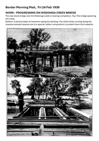
... by the Country Roads Board in 1939. The date was recorded on a small... by the Country Roads Board in 1939. The date was recorded on a small ...The Wodonga Creek Stock Bridge was constructed by the Country Roads Board in 1939. The date was recorded on a small plaque attached to one of the trestles. The bridge is an important reminder of one of the industries Wodonga was built on — cattle. It was constructed to develop a new stock route between Albury and Wodonga which would direct cattle away from the main bitumen roads and traffic bridges to the Wodonga Saleyards, where thousands of sheep and cattle were sold each month. It is a moderately tall timber trestle road bridge consisting of nine spans, with a deck length of 76 metres and deck width of 4.5 metres, and a maximum span length of 8.5 metres. The substantial timber deck featured decking laid horizontally and longitudinal running planks laid on top of it. The bridge also has timber side safety rails to discourage livestock from straying over the side. The bridge also became the centre of summer social activity for the young people of Wodonga as the area became a gazetted swimming area before the Wodonga Swimming Pool was constructed in 1959. In 1980 the Wodonga Saleyards were relocated to Bandiana to the east of the city. This meant that Wodonga Creek Stock Bridge was no longer needed for its original purpose. Although listed as a significant site by the Victorian Heritage and National Heritage Trust on 3/08/1998, the bridge fell into disrepair and also suffered damage from several floods. A suspension Bridge was constructed beside the Stock Route Bridge in 2013 and the old bridge was closed to traffic. Major damage caused by several floods, including a major flood in 2022 has resulted in the bridge being unsafe and its future is uncertain. The model of the Wodonga Creek Stock Bridge in our Collection made by Mr John Wild, depicts its current condition.The Wodonga Creek Stock Bridge is significant for technical, historic and social reasons and has been registered at the State Heritage level. It is of technical significance as a nine span bridge with tall timber trestles. Large bridges of this type are now very rare in Victoria. It is of historic significance as a surviving structurally authentic bridge designed specifically for livestock and drover use, on a historic stock route. The Stock Bridge is of social significance for its location at a popular riverside leisure spot since its construction in 1939.A collection of photographic images depicting the Wodonga Creek Stock Bridge. It contains both black and white and coloured images taken at different times in the Stock Bridge's history. A model of the Bridge made for Our Society is also included.wodonga creek stock bridge, wodonga heritage -
 Whitehorse Historical Society Inc.
Photograph, Springvale Road East Burwood
... for a considerable time before buildings appeared. The Country Fire Authority... buildings appeared. The Country Fire Authority, Vic Roads and World ...The Tally Ho Business Park was built on vacant land previously owned by the Methodist Church. The land was sold cheaply to the Church by Abel Hoadley, and the Tally Ho Boys Home was erected there. A change in the care of the boys meant that the land became vacant for a considerable time before buildings appeared. The Country Fire Authority, Vic Roads and World Vision are also located there.4 coloured photographs (a-d) taken at the intersection of Springvale Road & Burwood Hwy East Burwood. First stages of the Tally Ho Business Park in the background.tally ho business park, businesses -
 Orbost & District Historical Society
black and white photograph, July 1922
... by the Victorian Railways and the Country Roads Board. Constructed... by the Victorian Railways and the Country Roads Board. Constructed ...A new bridge over the Snowy River at Orbost was opened for traffic on June 20th 1922. It was designed for future joint use by road and railway traffic, but it was only used for road traffic. During the last few years the condition of an old suspension bridge [the 1893 bridge] which was the only vehicular crossing between the town of Orbost and the railway station, caused much concern. The structure was of timber, except for the wire suspension cables of its central span of about 100 feet. A design was prepared in 1914 for a permanent bridge with five spans of 85 feet composed of plate girders on concrete piers. With great increase in the price of steel work during the war, the cost of this design became prohibitive, and the need for a new structure becoming urgent, alternative proposals were investigated. As a result the present design was adopted as providing a sem-permanent bridge at moderate cost. The new bridge spans the river about 160 feet upstream from the old bridge on a slight skew, the piers being at an angle of 80 degrees with the centre line of the bridge. It has a camber of about 2 feet 5 inches in its total length of 527 feet. ( information from Newsletter March 2014 - Lois Crisp) The photograph shows Mrs James Cameron cutting the ribbon at the opening of the Orbost Pile Bridge in 1922. This second bridge, was built by the Victorian Railways and the Country Roads Board. Constructed at a cost of 35,000 pounds and used second-hand girders from the Flinders Street- Spencer Street viaduct. On July 4 1922 it was officially opened by Mrs James Cameron. Unfortunately, her husband, who had long championed the building of the bridge so that it would be ready for the railway to continue to the border, was too ill to attend the ceremony. In fact, James Cameron died on July 13 after a long and severe illness (ref. S.R.M. 20.7.1922). There is a section of this ribbon in the collection - Registration No. 366. This is a pictorial record of a significant event in Orbost's history.A black / white photograph of a pile bridge with a suspension bridge behind it. There are many people standing on the bridge.on back - "Opening of Pile Bridge - 1922"snowy-river-bridge ceremonies cameron-mrs -
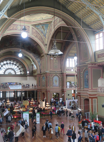
 Ballarat Heritage Services
Photograph - Photograph -Colour, Clare Gervasoni, Interior of the Melbourne Exhibition Building, 2019, 31/03/2019
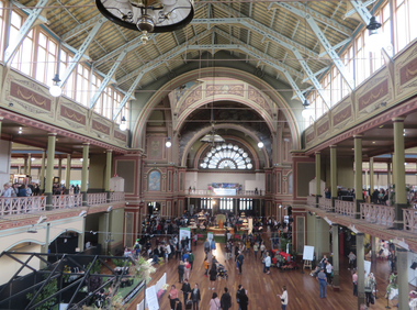
... the western annexe became home to the Country Roads Board. In 1932... Parliament in 1927 the western annexe became home to the Country ...A competition was announced to design a suitable building for the proposed Melbourne International Exhibition in December 1877. Eighteen entries were received. The winner of 300 pounds was Joseph Reed of the architectual firm Reed and Barnes. The foundation stone was laid by Governor Sir George Bowen on 19 February 1879. Prominent Melbounre builder David Mitchell, father of Dame Nellie Melba, won the tender to construct the main building. Exhibitors were able to move in by May 1880. On 01 October 1880 the Melbourne International Exhibition opened, when over 6000 people entered the main hall to see the Governor, the Marquess of Normanby open the show. Thirty three nations participated and ofver 32,000 exhibits were displayed. At the close of the exhibition on 30 April 1881 over 1.3 million people had visited the exhibition. In 1881 Victoria's population was just over 250,000. The management of the Exhibition Building and eight hectares of the Carlton Gardens was handed to the Exhibition Trustees by the Melbourne International Exhibition Commissioners on 01 OCtober 1881. The Trustees maintained the building for 'future public exhibitions and ... general public instruction and recreation' until 1996 when management of the building was transferred to Museum Victoria. In 1901 when the Australian colonies federated there was no capital and no federal parliament building. The Federal Parliament moved into the Victorian State Parliament building, and the State Parliament moved into the Western Annexe of the Exhibition Building for 26 years. After World War One, on 04 February 1919, the exhibition Building was turned into a hospital to treat Melbournians struck down with the Spanis 'Flu'. Initially housing 500 beds, the hospital grew to accomodate 2000 patients. Femals were located between the concert platform in the western nave and the done; male patients occupied the spaces beyond. The basement was used a a morgue. With the departure of the State Parliament in 1927 the western annexe became home to the Country Roads Board. In 1932 it was joined by the MOtor Registration Branch, and the Transport Regulation Board in 1934. They co-existedin cramped offices until the 1960s. In 1949 the oval at the rear of the ExhibitionBuilding was leased to the Commonealth Government for the establishment of the Migrant Reception Centre. When it closed in 1961-62, the centre comrised 29 bungalows over 1.4 hectare. The centre provided temporary accomodation for thousands of new arrivals from Britain. On 01 July 2004 the Royal Exhibition Building and Carlton Gardens were inscribed on the World Heritage List. It is the only 19th century Great Hall to survive largely intact, still in its original landscape setting, and still used as a palace of industry. The Melbourne International Flower and Garden Show is a flower show held annually since 1995 in early April each year, in Melbourne, Australia. It is located in the World Heritage Site of Carlton Gardens and the Royal Exhibition Building.[1] It is the largest horticultural event in the southern hemisphere, attracting over 100,000 visitors. It is rated among the top five flower and garden shows in the world. (Wikipedia)Colour photograph of the interior of the Melbourne Exhibition Buildings during the 2019 Melbourne Flower and Garden Show.melbourne international flower and garden show, carlton gardens, melbourne exhibition building, royal exhibition buildings -
 Ballarat Heritage Services
Photograph -Colour, Clare Gervasoni, Interior of the Melbourne Exhibition Building, 2019, 31/03/2019
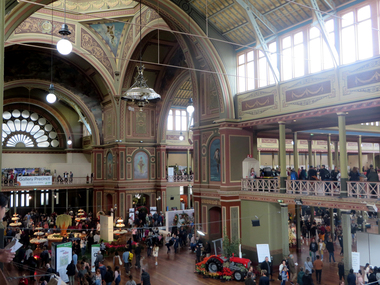
... the western annexe became home to the Country Roads Board. In 1932... Parliament in 1927 the western annexe became home to the Country ...A competition was announced to design a suitable building for the proposed Melbourne International Exhibition in December 1877. Eighteen entries were received. The winner of 300 pounds was Joseph Reed of the architectual firm Reed and Barnes. The foundation stone was laid by Governor Sir George Bowen on 19 February 1879. Prominent Melbounre builder David Mitchell, father of Dame Nellie Melba, won the tender to construct the main building. Exhibitors were able to move in by May 1880. On 01 October 1880 the Melbourne International Exhibition opened, when over 6000 people entered the main hall to see the Governor, the Marquess of Normanby open the show. Thirty three nations participated and ofver 32,000 exhibits were displayed. At the close of the exhibition on 30 April 1881 over 1.3 million people had visited the exhibition. In 1881 Victoria's population was just over 250,000. The management of the Exhibition Building and eight hectares of the Carlton Gardens was handed to the Exhibition Trustees by the Melbourne International Exhibition Commissioners on 01 OCtober 1881. The Trustees maintained the building for 'future public exhibitions and ... general public instruction and recreation' until 1996 when management of the building was transferred to Museum Victoria. In 1901 when the Australian colonies federated there was no capital and no federal parliament building. The Federal Parliament moved into the Victorian State Parliament building, and the State Parliament moved into the Western Annexe of the Exhibition Building for 26 years. After World War One, on 04 February 1919, the exhibition Building was turned into a hospital to treat Melbournians struck down with the Spanis 'Flu'. Initially housing 500 beds, the hospital grew to accomodate 2000 patients. Femals were located between the concert platform in the western nave and the done; male patients occupied the spaces beyond. The basement was used a a morgue. With the departure of the State Parliament in 1927 the western annexe became home to the Country Roads Board. In 1932 it was joined by the MOtor Registration Branch, and the Transport Regulation Board in 1934. They co-existedin cramped offices until the 1960s. In 1949 the oval at the rear of the ExhibitionBuilding was leased to the Commonealth Government for the establishment of the Migrant Reception Centre. When it closed in 1961-62, the centre comrised 29 bungalows over 1.4 hectare. The centre provided temporary accomodation for thousands of new arrivals from Britain. On 01 July 2004 the Royal Exhibition Building and Carlton Gardens were inscribed on the World Heritage List. It is the only 19th century Great Hall to survive largely intact, still in its original landscape setting, and still used as a palace of industry. The Melbourne International Flower and Garden Show is a flower show held annually since 1995 in early April each year, in Melbourne, Australia. It is located in the World Heritage Site of Carlton Gardens and the Royal Exhibition Building.[1] It is the largest horticultural event in the southern hemisphere, attracting over 100,000 visitors. It is rated among the top five flower and garden shows in the world. (Wikipedia)Colour photograph of the interior of the Melbourne Exhibition Buildings during the 2019 Melbourne Flower and Garden Show. Four mottoes are painted under teh windows of the dome: Dei Grecia (By the grace of God), Carpe diem (Make the most of the day), Aude sapere (Dare to be wise) and Benigno numine (With benighn power)melbourne international flower and garden show, carlton gardens, melbourne exhibition building, royal exhibition buildings -
 Ballarat Heritage Services
Photograph - Photograph -Colour, Clare Gervasoni, Interior of the Melbourne Exhibition Building, 2019, 31/03/2019
... the western annexe became home to the Country Roads Board. In 1932... Parliament in 1927 the western annexe became home to the Country ...A competition was announced to design a suitable building for the proposed Melbourne International Exhibition in December 1877. Eighteen entries were received. The winner of 300 pounds was Joseph Reed of the architectual firm Reed and Barnes. The foundation stone was laid by Governor Sir George Bowen on 19 February 1879. Prominent Melbounre builder David Mitchell, father of Dame Nellie Melba, won the tender to construct the main building. Exhibitors were able to move in by May 1880. On 01 October 1880 the Melbourne International Exhibition opened, when over 6000 people entered the main hall to see the Governor, the Marquess of Normanby open the show. Thirty three nations participated and ofver 32,000 exhibits were displayed. At the close of the exhibition on 30 April 1881 over 1.3 million people had visited the exhibition. In 1881 Victoria's population was just over 250,000. The management of the Exhibition Building and eight hectares of the Carlton Gardens was handed to the Exhibition Trustees by the Melbourne International Exhibition Commissioners on 01 OCtober 1881. The Trustees maintained the building for 'future public exhibitions and ... general public instruction and recreation' until 1996 when management of the building was transferred to Museum Victoria. In 1901 when the Australian colonies federated there was no capital and no federal parliament building. The Federal Parliament moved into the Victorian State Parliament building, and the State Parliament moved into the Western Annexe of the Exhibition Building for 26 years. After World War One, on 04 February 1919, the exhibition Building was turned into a hospital to treat Melbournians struck down with the Spanis 'Flu'. Initially housing 500 beds, the hospital grew to accomodate 2000 patients. Femals were located between the concert platform in the western nave and the done; male patients occupied the spaces beyond. The basement was used a a morgue. With the departure of the State Parliament in 1927 the western annexe became home to the Country Roads Board. In 1932 it was joined by the MOtor Registration Branch, and the Transport Regulation Board in 1934. They co-existedin cramped offices until the 1960s. In 1949 the oval at the rear of the ExhibitionBuilding was leased to the Commonealth Government for the establishment of the Migrant Reception Centre. When it closed in 1961-62, the centre comrised 29 bungalows over 1.4 hectare. The centre provided temporary accomodation for thousands of new arrivals from Britain. On 01 July 2004 the Royal Exhibition Building and Carlton Gardens were inscribed on the World Heritage List. It is the only 19th century Great Hall to survive largely intact, still in its original landscape setting, and still used as a palace of industry. The Melbourne International Flower and Garden Show is a flower show held annually since 1995 in early April each year, in Melbourne, Australia. It is located in the World Heritage Site of Carlton Gardens and the Royal Exhibition Building.[1] It is the largest horticultural event in the southern hemisphere, attracting over 100,000 visitors. It is rated among the top five flower and garden shows in the world. (Wikipedia)Colour photograph of the interior of the Melbourne Exhibition Buildings during the 2019 Melbourne Flower and Garden Show. Four mottoes are painted under teh windows of the dome: Dei Grecia (By the grace of God), Carpe diem (Make the most of the day), Aude sapere (Dare to be wise) and Benigno numine (With benighn power)melbourne international flower and garden show, carlton gardens, melbourne exhibition building, royal exhibition buildings -
 Eltham District Historical Society Inc
Slide - Photograph, Nyora Road, Eltham, c.1993
... Road was unsealed. This section was only a fire access track... Road was unsealed. This section was only a fire access track ...The east end of Nyora bewteen Stokes Place and Reynolds Road was unsealed. This section was only a fire access track as evidenced by the trees growing in the middle of the road. Real Estate agents would advertise homes as down a (dusty) country lane. The Nyora Road Resident Action Group arose to address concerns with Council regarding the dangerous conditions and traffic from outside the area using it as a 'rat-run' to avoid Main Road. Council traffic monitors showed that the amount of traffic was only 20% less than that of Mt Pleasant Road. The Action Group wanted the road closed at reynolds Road however Council elected to install speed calming devices along the sealed section between Stokes Place and Eucalyptus Road. Chicanes were added at several locations and a roundabout installed at Stokes Place in 2004. This remaining dirt section was sealed post 2004.35mm colour positive transparency Mount - Black and Whiteinfrastructure, roads, eltham, nyora road -
 Moorabbin Air Museum
Document (Item) - Ansett Transport Industries Ltd Company History
... Fire ..... 1939 Ansett Airways' War Years Pioneer Country..., The Hangar Fire ..... 1939 Ansett Airways' War Years Pioneer Country ...Includes a range of subjects as listed below, The Hangar Fire ..... 1939 Ansett Airways' War Years Pioneer Country Dealership And Road Services Ansett Hotels The Two-Airliner And The Ansett Purchase Of A.N.A The First Road Services 'Going Public" And The First Financial Crisis MacRobertson Miller Airline Services A History Of Aviation Spanning 56 Years Wridgways Ansett General Aviation Television Developments Austarama Television Pty Ltd And Universal Telecasters Qld Ltd The Rose Fight Thomas Nationwide Transport Ltd Take-Over Bid For Ansett Transport Industries Ltd The First Air Services Ansett Airways Ltd The Butler Take-Over ATI Associated Companies Other ATI Subsidiaries The Air Race ...... 1936 Ansair Pty Ltd -
 Eltham District Historical Society Inc
Photograph, Tess Justine (Nillumbik Shire Council), Murray's Bridge over the Diamond Creek, Eltham North, 19 Feb 2022
... a simplified version of the Country Roads Board’s (CRB) standard timber... a simplified version of the Country Roads Board’s (CRB) standard timber ...Murray's Bridge over the Diamond Creek on the Diamond Creek Trail just prior to demolition and replacement with a new steel bridge. Heritage advice obtained by Nillumbik Shire Council, following a suggestion by the Eltham District Historical Society (EDHS), is that the original bridge appears to have been a simplified version of the Country Roads Board’s (CRB) standard timber bridge design of the early-to-mid 1920s. In c1990 Murray’s bridge was renovated with three recycled steel girders as part of a bike/pedestrian path in the reserve. During these alterations many parts of the bridge were removed, and some were replaced. Heritage advice indicates the condition of Murray’s bridge is poor. The remaining original parts are all in poor condition, with severe weathering, splitting and rot, especially to the stringers retained on the bridge. Heritage advice is that Murray’s Bridge does not have sufficient significance in the cultural history of the Nillumbik area to warrant inclusion in the Nillumbik Shire Heritage Overlay and also does not have sufficient significance as a rare survivor to warrant inclusion in the Nillumbik Shire Heritage Overlay. There are no indications in the historical record that this site was individually important to the cultural history of this area. EDHS is comfortable with the heritage advice provided to Council and has worked closely on this project with Council. EDHS has suggested some of the removed timbers be used in the vicinity of the bridge for landscaping and possibly seating, so as to retain these remnants close to the site of the original bridge, which is the last old timber bridge along the lower reaches of the Diamond Creek. Mary (Sweeney) Murray and John Wright Murray selected 80 acres, Lot C Section 16 and Lot 5 Section 17 Parish of Nillumbik, under an occupation license in 1866. John died in 1867 and freehold was granted to his son John in 1873. The farm was known as ‘Laurel Hill’. John Junior was an Eltham Shire councillor and sometime president from 1887 up until 1897. He added Lot A Section 16 to the farm in ca1888. John and his younger brother James arranged to rent/purchase Lot B Section 17, across Diamond Creek to the west, in ca1900. It appears that John and James farmed separately for a few years, with a new homestead built for James ad family on the high point of Lot B Section 17 in ca1910. John sold off Lot 5 Section 17 in 1912. When John died in 1912 James took over the land on both sides of the Diamond Creek. The old homestead on the west side of the Creek disappeared. A farm bridge over Diamond Creek from this period may have been located close to the northern boundary of the farm. John Langlands, owner of the farm known as ‘Ihurst’ on the west side of Diamond Creek to the south of the Murray’s land, died in 1907. In 1909 his land was then subdivided into 100 lots to become the ‘Glen Park Estate’. Other similar subdivisions of nineteenth century farms around Eltham in this period included the ‘Franktonia (or Beard’s) Estate’ to the northeast and ‘Bonsack’s Estate’ between Eltham and Greensborough. Soon after the opening of the railway extension line from Eltham to Hurstbridge in 1912, Glen Park and nearby residents including James Murray agitated for a railway station or siding to be located half-way between Eltham and Hurstbridge, so that the Glen Park residents who used the railway daily did not have to walk into the Eltham or Hurstbridge stations. Some believed Coleman’s Corner (opposite Edendale Farm) was an appropriate spot for the platform. James Murray was among those who thought the railway should be located on his land, closer to half-way between Eltham and Hurstbridge stations. The Railways Commissioners warned that the locals would have to fund these works themselves. The Glen Park Estate residents initially had difficulty accessing Eltham by road, with only an old low-level bridge over Diamond Creek at the south end of their estate. A new timber trestle bridge across the creek, now on Wattletree Road, was opened in 1915. Road access to the north was gained in 1927 when the new Murray’s Road, which crossed the Murray’s land, was built. Residents continued to agitate for a Glen Park station. By 1926 the Railways Commissioners’ preferred site was on the Murray’s land. They arranged an estimate of cost of a full-length platform. The estimate was too much for the locals, who in 1928 argued unsuccessfully for a shorter and hence cheaper platform. By 1929 Murray had agreed to donate the land, but the locals would still have to fund the works. Murray decided, unilaterally it would appear, to commence work on a timber trestle road bridge over Diamond Creek to link the new Murray Road to the proposed station. Late in 1929 he stopped work on the bridge, for reasons unknown, but started work again and completed the bridge in 1931. There is no further newspaper evidence of the campaign for the Glen Park station until 1939, when Murray and another local, Mr Maxwell, met the Railways Commissioner. The Glen Park locale now included 45 homes on the west side of the creek and 20 on the Eltham side. Most of the residents used the train every day. The Commissioner remained adamant that only a full-length platform could be built for safety reasons. It appears the campaign dissolved at this point. The increasing move to cars may have had an impact. There is no evidence of Murray’s bridge ever being connected to Murray’s Road, or of it having wide use for any purpose by locals. James Murray died in 1947 and the farm was taken over by his son James (Jim). Jim started to sell off parts of the farm in the 1980s, retaining a few acres around the ca1910 homestead and building a new house there. Recreation reserves were established along the creek. In ca1990 Murray’s bridge was renovated with steel girders as part of a bike/pedestrian path in the reserve. The old farmhouse was demolished in ca2014. * * * A theory posted on local community Facebook groups was that the bridge was built in the 1860s and was built to be more robust than was necessary for the movement of cows from one side of the creek to the other. It was suggested the robustness was necessary to support the weight of gold ore being transferred from a mine on Murray’s land to a railway siding near Murrays Bridge (presumably for transfer and processing at Diamond Creek). Perhaps this may have been one of the motivators for Murray, who really knows? Knowing when mining operations ceased on his land and how that fits the overall timeline would be useful but at the time the bridge was built, local gold production was minimal at best. The known facts are: • The railway line came to Eltham in 1902. • The extension of the railway from Eltham to Hurstbridge was constructed in 1912 so no railway line even existed through Murray's property until 1912 and the Victorian Railways maps at the time show no such siding on Murray’s property. • In 1923 a new company was formed in anticipation of the old Diamond Creek Gold Mine being re-opened. The mine had been previously closed and flooded. It was noted in the press at the time that the mine was within a mile of the railway. Nothing really came of this. • Construction of Murrays Bridge was commenced by James Murray in early 1929 in anticipation of a proposed flag station being nominated on his land, but work ceased shortly afterwards. The proposed flag station was commonly referred to as Glen Park as the residents of the Glen Park Estate wanted Option 1, located near them with the platform adjacent to Colemans corner. This was probably never going to fly as it was virtually in eyesight of Eltham station. Allandale Road was the third option, but the Commissioners' preferred option was No. 2 - on Murray's property. • The Railway Commissioners were not going to finance any such station and the works had to be funded by private landowners and residents, hence Murray investing in this himself. • Murray recommenced work two years later and finished his bridge in 1931 but unfortunately for him, the proposed flag station never eventuated. The bluestone siding you reference may well have been built by Murray as part of the proposed station platform. • Up until then, apart from the Main Road bridge, which was washed away in 1924, virtually all local crossings over the Diamond Creek were low lying bridges – Kaylocks Bridge at Brougham Street, Diamond Street bridge, Glen Park Road bridge. It is expected that Murray also had a low-lying bridge to connect his land either side of the creek. These were all washed away or severely damaged multiple times in the 1920s. Lessons were learnt, and Murrays Bridge appears to have been built in accordance with Country Road Board standards of the time. Flood damage was ongoing, and even more recently constructed raised bridges kept getting washed away, e.g., the new Wattle Tree Road bridge in 1958 just months after completion. Murray’s bridge was reinforced with steel some 30 years ago presumably to provide additional floodwater resistance, given the history of bridges disappearing in floodwaters. • In March 1932 it was reported in the Advertiser that there were still some prospectors operating around Eltham North who apart from further scarring the face of the earth over the previous two years had gained significant experience but little gold - hardly a driving factor for constructing a dedicated railway siding and bridge to transfer gold ore. It is far more probable that James Murray was hoping to have the railway station located on his property and invested his money by building the bridge to lead to it as well as a station platform. Had the station eventuated, it may well have driven up the value of his land for subdivision and new housing estates like the Glen Park Estate. That did not eventuate. Whilst the bridge was indeed old (90 years), the core structure being completed in 1931, it had been modified substantially from original and hence had no significant historic value – i.e., it was not a representative example of its type, construction, and age. Given that the bridge was not worthy of saving, the Eltham District Historical Society with Council’s support, and the Eltham Woodworkers group endeavoured to see what suitable sized timbers were salvageable to fabricate a commemorative seat. Unfortunately, the experts at the Woodworkers group were unable to salvage any suitable length/width timbers to fabricate the seat due to the presence of rot. Last remaining wooden trestle bridge on the Diamond Creek Trail just prior to demolition and replacementBorn digital image (27)diamond creek (creek), diamond creek trail, murrays bridge, ‘laurel hill’, john wright murray, mary (sweeney) murra, john murray jnr, james murray, john langlands, ‘ihurst’, ‘glen park estate’, beard's estate, franktonia, bonsack's estate, glen park estate, glen park railway station -
 Eltham District Historical Society Inc
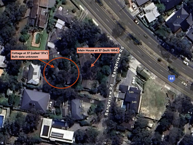
Document - Property Binder, 338 Main Road, Lower Plenty (also 37 Rangeview Road), March 2025
... to transfer portion for road widening scheme per Country Roads Board... to transfer portion for road widening scheme per Country Roads Board ...EDHS_03095-338 | EDHS_08635-37 338 Main Road Lower Plenty | 37 Rangeview Road, Lower Plenty Original Mudbrick cottage and studio designed and built by Eltham artist, David Alan Newbury See also EDHS_06090 David Newbury (Artist) David Newbury was married to Clare Margaret Newbury. According to the 1954 Electoral Roll they were living at 36A Murphy Street, South Yarra however around 1953 they purchased Lots 3 and 4 of Main Road Lot Plan LP 23911 in Lower Plenty. A building permit, No. 71, was issued 8 December 1953 for a 5-room house of Vertical Board construction, cost £2,840, builder L. Williams, owner D. Newbury of 36 Murphy Cl., South Yarra. The large house was in fact mostly built of mudbrick, the construction method was only just becoming recognised as an acceptable form in the late 1940s for issuance of a building permit. The house was commenced in 1954, designed by David Newbury and built by David Newbury, Horrie Judd and others. Information from Newbury family friends suggests that a second mudbrick building was constructed in the late 1950s, early 1960s for use as an artist studio by Newbury. The building was connected directly to the water mains at the time and was made suitable for living accommodation during the period Newbury was teaching at Bendigo. Apparently he and Claire rented out the main house during their time in Bendigo and would reside in the studio when visiting Melbourne. No permit for this studio was found in the Building Permit Register, Shire of Eltham, 1949-1960. The last recorded entries in the register are dated May 1960. This would suggest that the studio was constructed post May 1960. It is believed the studio was constructed during the latter period of Newbury’s teaching post in Bendigo so possibly late 1960/1961. In 1963 the Newbury’s address in the Electoral Roll has the property recorded as 220 Main Road, Lower Plenty. Between 1967 to 1980 the Electoral Rolls record the property as 338 Main Road. Today the address is 37 Rangeview Road, Lower Plenty. Contents: 1. Extract from 1942 Shire of Eltham Rate Book. Muriel Gladys Reitsma listed as owner 2. Extract from 1984-85 Shire of Eltham Rate Book for Rangeview Road. (No mention of No. 37 so was probably still listed as 338 Main Road.) 3. Certificate of Title, Vol. 5601 Fol. 1120089 - Issued to David James Graham of Lower Plenty, Builder, Heidelberg for Lot 32 Block B on Plan of Subdivision No. 7606, part of Crown Portion Two, Parish of Nillumbik, County of Evelyn, 29 October 1929 4. Certificate of Title, Vol. 8008 Fol. 076 - Issued to David Alan Newbury of 36 Murphy Street, South Yarra, School Teacher for Lot 3 on Plan of Subdivision No. 23911, part of Crown Portion Two, Parish of Nillumbik, County of Evelyn, 29 October 1953. Amended 24 June 1963 to transfer portion for road widening scheme per Country Roads Board Plan 6889 - Cancelled 24 September 1984 5. Certificate of Title, Vol. 9581 Fol. 583 - Issued to Paul Robert Biber and Althea Constance Biber of 139 Lower Heidelberg Road, Ivanhoe for Lot 3 on Plan of Subdivision No. 23911, part of Crown Portion Two, Parish of Nillumbik, County of Evelyn, 24 September 1984. Derived from Vol. 8008 Fol. 076 L276994V - Cancelled 20 Nov 1992 when subdivided from one to two lots in Vol 10092 Fol. 192 and Vol. 10092 Fol. 193; LP222467B 6. Certificate of Title, Vol. 10092 Fol. 192 - Transfer to Lawrie Mein of 20 Dewar Drive, Hurstbridge of Lot 1 on Plan of Subdivision No. 222467B, lodged 17 Feb 1993, Registered 29 March 1996. Parent Titles Vol 08008 Fol 077, Vol 09581 Fol 583 7. Survey Field Notes of Part of Crown Portion 2, Parish of Nillumbik, County of Evelyn - Portion of land bounded by New Eltham Road. Application 23911 dated 8 Sep 1952 with appended Surveyor Field notes per Application 7098; R.D. Steele, Licensed Surveyor, 18 August 1950 8. Survey Field Notes of Part of Crown Portion 2, Parish of Nillumbik, County of Evelyn - Portion of land bounded by Main Road and Rangeview Road; 2 Lot subdivisions, Vol. 9581 Fol. 583 Part Lot 3 on LP 23911 and Vol. 8008 Fol, 077 Lot 4 on LP 23911; Application 221805 dated 27 November 1989; W.J. Goodison, Licensed Surveyor, and attached Surveyor's Report dated 6 June 1990 (Withdrawn) 9. Survey Field Notes of Part of Crown Portion 2, Parish of Nillumbik, County of Evelyn - Portion of land bounded by Main Road and Rangeview Road; 2 Lot subdivisions, Vol. 9581 Fol. 583 Part Lot 3 on LP 23911 and Vol. 8008 Fol, 077 Lot 4 on LP 23911; Application 222467 dated 20 November 1992 (221805 resubmitted); W.J. Goodison, Licensed Surveyor, and attached Surveyor's Report dated 6 June 1990 Notes: Items 1 to 6 donated electronically Items 7 to 9 sourced from LASSI - SPEAR, Department of Transport and Planning, Victoria State Government, https://maps.land.vic.gov.au/lassi/SpearUI.jsp main road, property, mudbrick, david newbury, phoebe mason collection, rate books, shire of eltham, certificate of title, survey plan, 37 rangeview road, 338 main road, application 23911, lower plenty, map, surveyor field notes, application 221805, application 222467 -
 Bendigo Historical Society Inc.
Photograph - The Ruschmeyers - Publicans of the Town and Country Hotel, Diamond Hill Bendigo
... and was the licensee of the Town and Country Hotel in Woodward Road, Golden... and was the licensee of the Town and Country Hotel in Woodward Road, Golden ...John Christopher Ruschmeyer arrived in Melbourne aged 26 aboard the 'Essex' from Hanover, Germany via London in 1864. Shortly after his arrival in Australia he travelled to the Bendigo diggings. He became one of many thousands of German diggers on the Central Victorian Goldfields. He married Elizabeth Little Shepherd (Morrison) in 1874, a widow who had travelled down from Brisbane after the death of her first husband (John Shepherd). He became a naturalized citizen in 1893. Shortly after his marriage and having mined Golden Gully for some years he turned to hotel keeping and was the licensee of the Town and Country Hotel in Woodward Road, Golden Gully up until his death in 1911. The family of 4 daughters and 3 sons survived him. The family of Ernest, Maude, Christopher, Ethel and Edith (twins), Charles and Dolly Ruschmeyer all lived in the Bendigo area. His sons continued working in the mining tradition. He is buried with his wife in the Bendigo Cemetery. After his death Elizabeth moved to Thistle St until her death in 1922. Christopher Ruschmeyer and his family lived in a small house (now part of a poultry farm) in Woodwood road opposite the TOWN AND COUNTRY HOTEL. A brother Ernest Walter Ruschmeyer lived in a house next to the hotel. Ernest built the house. After Ernest's death in 1927 another brother Charles Hex Ruschmeyer married Ernest's wife Gertrude. The hotel was first licensed in 1898 and closed in 1916. John Ruschmeyer was the licensee until his death in 1911. Elizabeth took over the license until 1912 when it was sold to a Catherine E Hoffaer. This information is provided by Neil Graham of Strathfieldsaye whose Grandfather on his Mother's side was John Ruschmeyer and John Christopher Ruschmeyer was his Great Grandfather.Digital image: image shows Town and Country Hotel, Diamond Hill. Ruschmeyer's were the publicans. Standing outside hotel, were from left, Ethel, Dolly, Maude, Edith, Elizabeth.person, family, ruschmeyer, john christopher ruschmeyer, town and country hotel, ruschmeyer, diamond hill bendigo -
 Melbourne Tram Museum
Album - Photo Album, John Etkins, Ray Marsh, 1990's
... at Malvern Depot – 18-5-1992 59 1018 Country Road advert tram 59 8... Country Road advert tram 59 8 Z class – decorated tram – Essendon ...Photo Album - 48 sheets bound with a white circular metal/plastic spiral bound within a heavy duty cardboard cover, with glued cover pages, plastic covered with an index sheet. Allows for three photographs per page. Not known whether the plastic envelope for each photograph is of archival quality. No Manufacture detail, though has a bar code on the bottom left hand corner of the rear cover. Cover is a reproduction from a painted art piece. Listing of photographs given on htd1800-RayMarshalbum.pdf Dates given when written on the rear of the photograph. Compiled by John Etkins from photographs given to him by Ray Marsh. 1990's to 1993 generally. Page Tram/s Notes – dates given when on rear of photograph. 1 226 Loading passengers – ex MMTB Annual Report? 1 957 City Circle 1 “hands off our trams” protest march 2 2100, 231 South Melbourne Depot – 10-4-1993 2 676 And many others – Hawthorn Depot 2 217 Princes Bridges 3 380, 104 St Kilda Road 3 106, 104 Essendon Depot 3 431 As a W1 4 1011 Fresh fruit tram, Preston Depot 6-12-1992, 4 824 Day in Day out, Brunswick and Victoria Parade 29-4-1993 4 722 Art tram 5 ? Advert tram – Imperial China 5 237 Stubbsy tram – TrippleM? 6 856 City Circle – with gas and fuel building – 31-7-1994 6 925 City Circle - with gas and fuel building – 31-7-1994 6 728 City Circle – 10-8-1994 7 246 Navy tram x three pics – July 1992 8 ? Gold tram advertising Georges 8 990 Advertising Telstra– 29-4-1993 8 749 Art tram? 9 990 NRMA - 1-3-1994 9 727, 215 Public Transport 9 920 Advert tram with a picket fence 10 Bendigo 21 Preston Workshops 11-3-1993 10 774? W5 being rebuilt at Preston – 21-10-1991 11 ? Bogie cable trailer at Preston – 29-4-1993 11 922 Interior view of a tram – being modernised – 11-3-1993 11 922 Preston Workshops 29-4-1993 12 1018 Workcare tram at Preston 1994 – 11-8-1994 12 774 Preston Workshops – 20-12-1993 12 8 Preston Workshops – 1-10-1992 13 380 Preston Workshops 13 8 Preston Workshops 13 20, 8 Preston Workshops 14 721 Preston Workshops 20-12-1993 14 ? Tramways painted artist tram featuring a driver and workshop 14 Traverser Preston Workshops 15 2110, 2106 Preston Workshops 15 ? Preston Workshops 15 2130 Interior Preston Workshops 20-12-1993 16 Set of three pics Elizabeth St floods – 17-2-1972 17 Set of three pics Elizabeth St floods – 17-2-1972 18 676 Turning into Swanston St from Batman Ave 18 676 Kew Depot – 10-11-1991 18 237, 676, 611 Kew Depot – 10-11-1991 19 214, 676 South Melbourne Depot – Kingsway 19 217 Spencer St 19 214 Advertising Kew Depot Open Day -8-12-1991 20 231, 676 Advertising Kew Depot Open Day -8-12-1991 20 Zoo tram, 256 Outside Kew Depot 20 214 Hawthorn Open Day with band 21 Zoo tram x 3 pics And horses, Kew Open day 22 231, 431 Kew Depot 22 892, 214 Kew Depot 75 years, Postcard – 1991 22 282 Kew Depot – with the name Monique on the tram and a lady standing alongside 23 238, 233 Kew Depot 23 236, 892, 282 Kew Depot – 25-4-1992 23 232, 236, 282 Kew Depot 24 2112 Port Melbourne line – with long grass – 11-4-1993 24 469, 2037, ? 2015 South Melbourne Depot 24 1018 or 976? Advertising a PTC Open Day – 20-10-1991 – In Swanston St - see Reg Item 1845 25 250 Bourke St 25 2100 Running into Preston Workshops 25 282, 1003 Collins St in the rain 26 Logo PMTT 26 Point cover With P&MTT cast into the cover 26 Foundation Stone Person reblocking in gold, a PMTT Foundation Stone 27 Logo Tramway Board 27 Logo MMTB logo 27 Logo Footscray Tramways Trust 28 217 And 2’gauge W2 – South Melbourne Depot – 20-10-1991 28 164 Somewhere? 28 1018 Advert tram – “Moro”, Preston flyover 29 V214 x 3 pics Kew Depot 30 611 Whitehorse Road, Balwyn 5-10-1991 30 976 x 2 pics Advert tram – have a red instead 31 610 Malvern Depot 31 138 (max tract) Flinders St 31 138 (max tract) Bourke into Spencer 32 844 Victoria Parade with R10 behind 32 264 With a TV interview being undertaken 32 2066 Elizabeth St – 29-4-1993 33 255 x 2 pics Derailed at Kew Depot 33 253 Derailed outside the Beehive Hotel 34 214, 892, 611 Re-enactment of Victoria Bridge to Esplanade service – 10-11-91 34 726 Art tram? – Swanston St with overhead trucks in background 34 10W Reblocking scrubber car at Brunswick Depot 1999 35 2085 At Preston workshops over an inspection track section 35 731 St Georges Road, road being rebuilt – Nov. 1991 35 Preston Jtn Junction at Workshops being relaid 36 1003 St Georges Road, Nov. 1991 trackworks 36 St Georges Rd Track being rebuilt – Nov. 1991 has temp track cross over 36 Victoria St Victoria St being reconstructed 6-9-1992 37 East Burwood Extension works – 18-2-1993 37 East Burwood Re-building crossover – 18-2-1993 37 Victoria St Victoria St being reconstructed 6-9-1992 38 19W, 16W Bylands – 5-12-1993 38 R10 Kew Depot 38 Workers Kew Depot pushing on a post 39 R10 R10 towing a B class tram- Royal Parade? 39 11W, 10W? South Melbourne Depot 39 Overhead Overhead truck at Kew Depot 40 Kew Depot Demolition works opposite depot 40 613? Malvern Depot on special tram 40 256 zoo tram Royal Park tram at Kew Depot 41 B class Bundoora line 1993 41 231, 611 Kew depot 75th anniversary tram 41 469, 287 Kew depot 42 510 Spring St into Bourke St – 28-4-1993. “42nd street promotion. 42 153 High St Northcote, Bundoora 42 611 Kew Depot, Nov. 1991 43 195? Simpson St siding – 25-4-1993 – 7 trams in all 43 646 Route 12, with fire station in background – Gisborne and Victoria 43 961 Burke Road, Camberwell, 10-8-1994 44 760 Art tram 44 938 Sam the tram, Flinders St 44 1014 Gilbert Road, West Preston, June 1994, advert for AGC 45 965 Daimaru advert tram, Swanston St 45 1018 Express post advert tram, Swanston St. 45 1024 Advert – lego exhibition – Swanston St 46 104 Camberwell depot 46 611 Looking towards driver’s controls from interior. 46 W1 Interior photo showing tip over seats 47 Cable car Interior photo – could be zoo tram 47 510 Interior, 28-4-1993 47 214 Kew Depot, night shot, Oct. 1991 48 246, 237 Kew depot, 13-9-1993 – Stubbsy and Energy Victoria advert 48 246, 231, 237 Kew depot, Navy, 75th anniversary of Kew and Fox Fm advert 48 2014, 2072 South Melbourne – tt line? Advert tram 49 59 And six other trams in front of Preston Workshops 49 1024 MMTB Christmas Tram, 1970 49 2001 Camberwell Depot 50 725 Preston depot area – tram has a red upper half 50 725 South Melbourne depot – now has Xmas decorations 50 1026 Bourke St, Christmas 6-12-1993 51 933 Victoria Parade shunt and other A class tram – Autumn 51 829 Art tram 51 39 Advert tram – Crime prevention 52 Connie Connie at night = has jeans on 52 1?? Has a MET inspector standing in front of number – Latrobe uni tram 52 611 Kew Depot 53 237 Fox FM Black Thunder tram at Kew Depot, August 1992 53 237, 611, 892 Victoria Bridge re-enactment – 10-11-1991 53 237 At Kew depot with 4 people, including Hugh Waldron 53 442, 10W South Melbourne Restaurant tram and works car 53 W2 At Wattle Park 53 School art Photo of students holding artwork on the zoo tram 256 at Kew 54 138 And many others 54 469 Launch of the Melbourne Tram by the PTC 54 School art Photo of students holding artwork on the zoo tram 256 at Kew 55 B2 Elizabeth St terminus, Christmas 1994 55 8 Z8 Swanston St, April 1993 55 504 Clifton Pugh – Preston Workshops 56 138, 180, 214 Hawthorn Depot display 56 650, 510 Hawthorn Depot 56 469 Camberwell 57 568 Bridge Road Richmond by cable tram depot 57 ? Advert tram – Falls Creek 57 995 Malvern Road, 18-5-1992 58 457, 217 etc Swanston St display 58 231, 611 Kew 75th Anniversary 58 682 Artist tram at Malvern Depot – 18-5-1992 59 1018 Country Road advert tram 59 8 Z class – decorated tram – Essendon Depot 59 947 Metland Safety Express – safety tram – Kew depot 60 101 x 2pics Decorated for RAAF 70th Anniversary 60 2082 Near East Preston Depot, with destination “Next Stop Mill Park” 61 475 After sale and disposal 61 585 After sale and disposal 61 651 After sale and disposal – Diamond Creek – 9-8-1994 62 386 After sale and disposal – Sunbury 62 590 After sale and disposal – Hall ACT 62 476 After sale and disposal – Kinglake 63 11W Bundoora Extension – track being opened 63 947 Metland Safety Express – safety tram – Kew depot 63 Model 2,3 2’ gauge model trams 64 Model 2 Ditto 64 250 After sale and disposal 64 293 After sale and disposal – Diamond Ck – 9-8-1994 65 246, 231, 237 Kew depot, Navy, 75th anniversary of Kew and Fox Fm advert 65 1002 Advert tram – Salvation Army 65 231, 29 Kew Depot 66 246, 231, 237 Kew depot, Navy, 75th anniversary of Kew and Fox Fm advert 66 646, 935, 1002 Kew depot 66 220, 60 Preston Workshops? 67 851, 814 Malvern Depot 3-9-1992 67 726 Malvern Rd at Glenferrie Road – 18-5-1992 67 237, 133 Victoria Parade 1996 68 814 and others Interior Malvern Depot – 18-5-1992 68 231 75th Kew depot anniversary at depot 68 231 75th Kew depot anniversary at depot 69 1024 Malvern Depot 10-11-1991 69 1011 Advert tram Melbourne City Toyota 69 106, 180 Swanston St 70 190, 568 Camberwell Depot 70 431 Flinders St – tram event 70 20, 138 Camberwell Depot 71 431 Flinders St – tram event 71 237 Fox FM Thunder Tram 71 2057, 2014 Elizabeth St, Vic Market 29-4-1993 72 676, 611, 892 Victoria Bridge re-enactment – 10-11-1991 72 Ceremony Victoria Bridge – mayor and others event 72 214 214 on the bridge 73 164 Lygon St – former outer circle line level crossing in view 73 841 Swanston Walk 29-4-1993 74 821 St Georges Road, April 1993 74 431, 231 Victoria Parade 74 217, 676 Passing Camberwell Depot 75 Oporto 018 Clarendon St 6-3-2003 75 3007 Albert Park – 7-3-2003 75 3001, 018, 3502 Docklands – 10-3-2003 76 Oporto 018 Docklands – 16-1-2003 76 Oporto 018 Flinders St 7-3-2003 76 3502 Swanston St at Flinders St -8-3-2003 77 16 Kew Depot, Jan 1991 77 112, 110 Bundoora 4-9-1992 77 738 Camberwell Feb 1991 78 1011 Thornbury Jan 1991 advert for City Toyota 78 101 Bundoora – RAAF tram 4-9-1992 78 814 Art tram – Swanston St August 1992 79 1024, 469, Z3 Preston Workshops – 469 as the Melbourne Tram – 9-9-1992 79 961 Malvern Depot 3-9-1992 79 242 Single line working in Victoria St 6-9-1992 80 781 Thornbury, the hump, Preston Workshops Jan 1991 80 2104 Preston Workshops 9-9-1992 80 2100 Launch, Preston Workshops 9-9-1992 81 5W + 1A 5 x W at Kew Depot 3-2-1991 81 676 Kew Depot 21-2-1991 81 873, 2016 Brunswick depot 2-3-1991 82 231 Kew Depot Yard – 21-1-1991 82 157, 158 Brunswick Depot – 2-3-1991 82 2057, 873, 158 Brunswick Depot – 2-3-1991 83 802 Art Tram - Franklin St from the signal box 2-3-1991 83 990 990 Evian advert tram, Franklin St signal box 2-3-1991 83 920 GIO Advert Tram with Bushels tea and Yellow Pages? Adverts 84 721 Art Tram, Franklin St signal box 84 976 St Georges Road, Jan 1991 – advert tram Capital society 84 731 St Georges Road, Jan. 1991 Art tram 85 10W Victoria Parade, Brunswick St, 1/3/1991 85 10W, 9 or 11W South Melbourne depot 85 10W Bundoora Terminus 4-2-1991 86 11W City Baths 86 10, 16 Camberwell Depot 6-12-1990 86 944 Glenhuntly Depot 18-2-1991 87 2011 Spring St – Princess Theatre, March 1990 87 294, 239, 277, 243, 259, 280 Kew Depot 87 296 Kew Depot 88 1015, 16 Batman Ave 19-1-1991 88 963, 948, 935, 996, 892 Kew Depot 3-2-1991 88 Victoria St Victoria St Richmond Reconstruction 6-2-1992 89 1014, 990 Batman Ave 19-1-1991 (Image added i5 and rear view added 23-12-2018, scanned for Dale Budd. 89 920 920 – GIO advert tram, 760 art Tram Collins at Spencer 17-10-1990 89 610, 611 Kooyong Station level crossing 30-12-1990 90 95 Royal Park, 15-2-1991 90 2057, 873, 158 Brunswick Depot – 2-3-1991 90 10 Camberwell Depot 6-12-1990 91 Bendigo 44 In Prahran and Malvern Tramways Trust Colours 1986 –Black and white photo. Listed 5-11-2016See note page 1 and on image 3trams, tramways, album, photo album, tramcars, the met, yarra trams, kew depot, brunswick depot, advertising trams, transporting art, preston depot, hawthorn, bundoora, st georges rd, victoria st, camberwell depot, tram r10, 8, 10w, 10, 11w, 16, 16w, oporto 018, 19w, 20, bendigo 21, 29, 39, bendigo 44, 59, 60, 95, 101, 104, 106, 110, 112, 133, 138, 153, 157, 158, 164, 180, 190, 195?, 214, 215, 217, 220, 226, 231, 232, 233, 236, 237, 238, 239, 242, 243, 246, 250, 253, 255, 256, 259, 264, 277, 280, 282, 287, 293, 294, 296, 380, 386, 431, 442, 457, 469, 475, 476, 504, 510, 568, 585, 590, 610, 611, 613?, 646, 651, 676, 682, 721, 722, 725, 726, 727, 728, 731, 738, 749, 760, 774, 781, 802, 814, 821, 824, 829, 841, 844, 851, 856, 873, 892, 920, 922, 925, 933, 935, 938, 944, 947, 948, 957, 961, 963, 965, 976, 990, 995, 996, 1002, 1003, 1011, 1014, 1015, 1018, 1024, 1026, 2001, 2011, 2014, 2015, 2016, 2037, 2057, 2057, 2066, 2072, 2082, 2085, 2100, 2104, 2106, 2112, 2130, 3001, 3007, 3502 -
 The Beechworth Burke Museum
Photograph, Late 1800s
This photograph depicts six men and two horses with carts in the process of constructing a road. The men each stand in a relatively relaxed position, posing for the camera. However, the amount of upturned soil surrounding them suggests the hard work they have endured, armed only with pitchforks and shovels. The creation of new roads in the Beechworth area had become a priority for the Beechworth council in the second half of the nineteenth century. This included connecting roads which radiated out of Beechworth to surrounding towns. This led to the expansion of the local government authority over the surrounding countryside, greatly strengthening Beechworth's central position. The use of horse and cart to take away the removed soil, as well as the style of the men's attire, suggests that this photograph dates back to the late 1800s. It can also be assumed that this photograph was taken somewhere in the surrounding hills of Beechworth. This photograph is historically significant as it provides insight into the rapid expansion of roads in and around Beechworth during the second half of the nineteenth century. Sepia rectangular photograph on matte photographic paper mounted on card Reverse: BMM 2982 / road construction, beechworth roads, 1800s, 1800s beechworth, beechworth hills, horse and cart, beechworth road making, beechworth council roads, road expansion, beechworth surrounding hills -
 The Beechworth Burke Museum
Photograph, 1910
Taken in 1910, this photograph depicts a scene of Bridge road in Newtown, Beechworth. Walking on the road are two men on horseback, one of which is pulling a carriage with a small dog standing beside it. Behind them are a line of small buildings and shops. Small industries began to expand dramatically in Beechworth, particularly during the 1860s, leading to a strengthening of the towns economy. As early as 1853, areas surrounding the waterway known as Spring Creek were surveyed with the intent of mapping out plans for new roads and building allotments. Land was sold and new buildings were erected, creating an expansion of the Beechworth township and retail services. One building shown in this photograph is Straughair and Duncan's Beechworth Foundry. This business was established in 1858 through the partnership of Mark Straughair and John Duncan. It dealt mostly in the manufacturing of castings and mining machinery, receiving orders from all over the Ovens district. The Business eventually collapsed after the deaths of Straughair in 1882 and Duncan in 1896 but was reopened by W.H. Phillips in 1905. The two other buildings are both associated with the name McKenzie. Evidence suggests that the McKenzie family has a long association with the town of Beechworth. This photograph is historically significant as it provides insight into the nineteenth and twentieth century industrial expansions that happened in the area of Newtown, leading to the urbanisation of Beechworth. Black and white rectangular photograph printed on matte photographic paper mounted on card.Reverse: Newton / 1997.2648 / 33 Newton Beechworth / 84-219-1 / McKenzies / BMM3055 / newtown beechworth, bridge road, 1910, j. duncan, r. mckenzie, m. straughair, industrial growth, ford street, beechworth foundry, straughair and duncan, mckenzie and sons grainstore, mckenzie family store -
 The Beechworth Burke Museum
Photograph, Approximately 1930
Taken in approximately 1930, this photograph depicts the ruins of Rosehill Dairy. A woman stands beside the ruins, observing them solemnly. The owner of this once prominent dairy, John Brewer, was born in Cornwall, England in 1832. After coming to Australia in 1849, Brewer worked in various forms of livestock transportation. Upon hearing of the vast discovery of gold in Victoria's north-east, he engaged in mining in the Ovens Goldfield district before starting his own dairy on Wooragee road (now Old Wooragee road). The Wooragee Valley, approximately five kilometres north of Beechworth, was used extensively during the nineteenth century to build farming practices in the area, possessing eighteen farms by 1860. Brewer enjoyed a prosperous career in the dairy industry, personally delivering milk to the residents of Beechworth. He died on the thirteenth of August 1915, a few weeks shy of his eighty-third birthday. As this photograph is dated approximately fifteen years later, it can be assumed that the dairy fell into neglect following his death. This photograph is historically significant as it provides insight the development of the dairy industry in Beechworth in the second half of the nineteenth century.Black and white square photograph printed on matte photographic paper Reverse: 1997.2912 / John Brewers / Rosehill / Dairy / top of the 'rising sun' /john brewer, 1930 beechworth, rosehill dairy, dairy industry beechworh, dairy factories beechworth, dairying, dairy farm beechworth, wooragee road, wooragee valley, old wooragee road, dairy farm ruins -
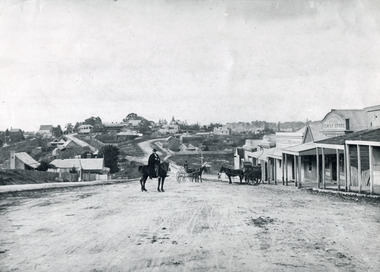 The Beechworth Burke Museum
Photograph, c1900
Believed to have been taken sometime between 1858 and 1908, featuring a man with moustache, dressed in hat and long riding coat, seated on a bob-tailed horse, is stopped in the middle of a wide dirt road in Beechworth. He is outside a row of businesses, including R.McKenzie & Sons Grain Store and Mackenzie Family Store (Wholesale & Retail Est. 1855), along a sloping hill. Behind the main rider are a parked horse and laden two-wheeled cart backed up directly outside the grain store's verandah, and another man is driving a horse and four-wheeled wagon forward towards them. At the bottom of the hill is a bridge (Newtown Bridge) with forked road on the far side, leading to a number of houses on both sides of another hill. This image is looking down Bridge Street, Newtown, Beechworth and across to Ford Street (left) and High Street (right). Road-making was a focus of town development during the 1850s, and the wide streets were created on the instructions of the surveyor-general to be between sixty-six and ninety-nine feet wide to give the town a pleasing aspect.This photograph is important in showing the development and expansion of the various businesses and buildings in Bridge Street of Newtown, Beechworth. Black and white rectangular photograph printed on paperReverse: 6980/ PH 118/ 1998.00059/beechworth, new town, newtown, newtown beechworth, local business, mackenzie family store, mackenzie's family store, mackenzie, grain store, bridge, ford steet, high street, colonial australia, australian gold rushes, mining technology, beechworth historic district, indigo gold trail, migration, indigo shire, mckenzie and sons grainstore, mckenzie family store, mckenzie, newtown bridge -
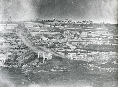 The Beechworth Burke Museum
Photograph, c.1863
Taken in Beechworth, this photograph depicts Albert road bisecting the Spring Creek Diggings. The foreground of the photograph features a small bridge, while in the background, right-hand-side, Benevolent Hospital can be seen. In the centre of the photograph can be seen a horse and cart travelling along the road. This photograph shows historical and research value in its depiction of Beechworth in the late 1800s. It features a key historical site, the Benevolent Hospital, as well providing a historical look at a street that operates in Beechworth in the present day.Black and white, rectangular photograph printed on matt photographic paper, unmountedReverse: PH 238 / 1997.2462 / Albert Road . 1863 . 1800s beechworth, 1860s beechworth, beechworth, spring creek, benevolent asylum, albert road -
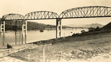 The Beechworth Burke Museum
Photograph
Taken between 1928 and 1930, depicted is the Bethanga Bridge under construction. The Bridge was completed in 1930 and was built to assist residents of the Bethanga district to travel to Albury. Other bridges would become submerged by the backed-up water of the Murray and Mitta Rivers so the Bethanga bridge was built two miles above the Mitta Weir. The Bethanga Bridge was built north of the future Hume Dam which would be completed in 1936. At 2430 feet long, Bethanga Bridge was the longest road bridge in Australia at the time of its completion. The Bridge is 20 feet wide and made up of nine 270 feet long spans. Materials used include ten tons of paint for the steel works; 1600 tons of steel; 900 tons of timber for the decking; and reinforced concrete for the piers. The tender for the construction was awarded to C. Ruwolt Pty. Ltd., engineers who were located on Victoria Street, West Richmond. The contract was awarded for £71,890. It was predicted between 250 and 300 men would find employment on the project. The news was well received by trade unions at the time as there had been a drop in available engineering work.This photograph is historically significant as it depicts the progress of the Bethanga Bridge construction, which was important infrastructure for the area. It is also a good example of methods used in the area to assist in travel over the river prior to the construction of the Hume Dam.Black and white rectangular photo printed on matte photographic paper.Reverse: 1997 3186 / 84-19-3 / This is the bridge. / It is not yet open to traffic / yet. will not be completed / until May next / It is a wonderful bridge the / pillars are 100 feet high. / KODAK PRINT Envelope Obverse: Peterson PHOTO / Hume Weir Envelope Reverse: BMM 84-20-1,2+3. bethanga bridge, lake hume, hume dam, hume weir, murray river, bridge, bethanga, albury -
 The Beechworth Burke Museum
Photograph, Unknown c.1930s
This image shows Bethanga Bridge, which was constructed between 1927 and 1930 in Albury, NSW. The bridge was a necessity due to the building of the Hume Dam (Wier), 1919-1936. Bethanga Bridge is a long, nine-span, riveted-steel, variable depth, Pratt Truss road bridge of nine principal spans of 82 metres and a total length of 752 metres over the flooded valley of the Murray River, now part of Hume Reservoir. Because of its unique location, over the waters of a dam with the border running down the centre of the body of water, the Bethanga bridge is the only built structure shared by both New South Wales and Victoria. It was built 1.6 kilometres upstream of the dam and in 1961 was raised 300mm, with a concrete deck replacing the original wooden deck. The State Rivers and Water Supply Commission of Victoria and the New South Wales Department of Public Works were responsible for the construction works for the Hume Weir under the River Murray Waters Agreement. It is apparent that a similar joint arrangement was made for the construction of the Bethanga Bridge as part of the Hume Weir works.This photograph of the Bethanga Bridge is of historical significance as it showcases the architectural skills of Percy Allen and Vincent Packer. Additionally, it reveals the environmental landscape of the 1920s-1930s, is linked to the Hume Dam and both New South Wales and Victorian heritage. Unmounted black and white rectangular photograph. Reverse: 1997.3196 84-20-3bethanga, bethanga bridge, hume dam, pratt truss, murray river, hume weir, transportation -
 The Beechworth Burke Museum
Photograph
This rectangle black and white photograph shows a bush scene with part of a suspension rope and wooden plank bridge visible in the middle of the image. It is likely this suspension bridge was used by the Tannery workers to move between the town and the Ovens Tannery located South-West of Beechworth due to its secluded bush location, the bridge likely spanned the gorge across Spring creek. The tannery itself was located alongside Gimlet Creek, about three kilometres from town, down what is now known as Malakoff and Old Tannery Road but which at the time was remote and accessed through bushland. The Ovens tannery was stablished in 1858 by Matthew Dodd and Hallahan and later Matthew and his brother Thomas Dodd in 1866 who developed it over the years. According to Doyle, 'we have little information about its early operations except the tannery itself comprised four small buildings' by 1870 ‘a small village with gardens of vines and fruit trees surrounded the tannery’ (Woods, 121), and by 1887 the Tannery employed fifteen men. The Ovens tannery was among several new businesses establishing themselves such as a foundry that brought industrial manufacturing alongside the developing township and which strengthened the economic stability of Beechworth after the receding mining surge. According to Woods (p. 121) in the 1860’s the government spent considerable sums to establish several public buildings such as the Benevolent Asylum, the Hospital and Insane Asylum to support those in need of care in the area directly after the Indigo gold rush which had left Beechworth, a fairly remote regional and newly formed township (Gold was first discovered in Beechworth in 1852) with a number of infirm and destitute people in its wake and which due to the support and establishment of these facilities ‘made Beechworth a significant social welfare centre in Victoria’ (Woods, p. 121). The tannery provided employment and connected the regional centre with other parts of Victoria and the wider colonial outposts and would have been a welcome opportunity for those seeking work after gold was no longer a source of income.A good example of the ingenuity of regional settlers to achieve what would have been a difficult and remote construction of a bridge as a means of access. This bridge is evidence of planning and forethought and shows dedication to establishing a life in a remote landscape.Black and white rectangular photograph printed on paperreverse: / 2983 / / BMM2983 /black and white photograph, bush, suspension bridge, rope bridge, tannery, spring creek, ovens tannery, bushland, gimlet creek, matthew dodd, beechworth -
The Beechworth Burke Museum
Audio - Oral History, Jennifer Williams, Mr Tom Carey, 3/08/2000
Mr Tom Carey was born in 1940 in Beechworth to family from Beechworth and Woolshed. His family had strong associations with Australia's Gold Rush, with grandparents having followed the rush from town to town, and parents in Beechworth. Tom has strong associations with Beechworth and its surrounds, with his family having some connection to the Kelly Gang. Tom worked in many industries in Beechworth, from the Bridge Road, Price’s Store, tannery, post office, the Kiewa Murray Water Authority, and the Beechworth Council. This oral history recording was part of a project conducted by Jennifer Williams in the year 2000 to capture the everyday life and struggles in Beechworth during the twentieth century. This project involved recording seventy oral histories on cassette tapes of local Beechworth residents which were then published in a book titled: Listen to what they say: voices of twentieth century Beechworth. These cassette tapes were digitised in July 2021 with funds made available by the Friends of the Burke. Mr Tom Carey account of his life in Beechworth and the local area during the 20th century is historically and socially significant to the cultural heritage of the region. He details important historical events and hardships in the region's history that had a lasting local, regional and national impact, including Australia during war time, economic struggles, and women's and men’s societal roles in a rural area. This oral history account is socially and historically significant as it is a part of a broader collection of interviews conducted by Jennifer Williams which were published in the book 'Listen to what they say: voices of twentieth-century Beechworth.' While the township of Beechworth is known for its history as a gold rush town, these accounts provide a unique insight into the day-to-day life of the town's residents during the 20th century, many of which will have now been lost if they had not been preserved. This is a digital copy of a recording that was originally captured on a cassette tape. The cassette tape is black with a horizontal white strip and is currently stored in a clear flat plastic rectangular container. It holds up 40 minutes of recordings on each sideMr Tom Carey/ beechworth, oral history, burke museum, tannery, beechworth council, kelly gang, bridge road, price’s store, post office, the kiewa murray water authority, woolshed, gold rush, carey, tom carey, listen to what they say -
The Beechworth Burke Museum
Audio - Oral History, Jennifer Williams, Mr John Clemens, 2000
Mr John Clemens was born in 1913 to Australian parents. His father worked in building roads which led to the family's move from Sunnyside Gen Willis to Beechworth. His father was part of the road making team on the Buffalo River Road between Myrtleford and Beechworth. John worked as a motor mechanic in his early years, having left school in sixth grade. He later worked carting wood (independently) and drinks for Murray Breweries/Billson's Breweries. He delivered drinks and wood to the Old Hospital after its relocation in 1940, to Bonegilla Migrants Camp and got to know most of the townspeople. He recounts his interactions with various members of the community, highlighting the importance of the Zwar Tannery, which John recounts as employing approximately 200 people (dating this recollection to approximately 1938). This oral history recording was part of a project conducted by Jennifer Williams in the year 2000 to capture the everyday life and struggles in Beechworth during the twentieth century. This project involved recording seventy oral histories on cassette tapes of local Beechworth residents which were then published in a book titled: Listen to what they say: voices of twentieth century Beechworth. These cassette tapes were digitised in July 2021 with funds made available by the Friends of the Burke.John's interview demonstrates the dynamics of the Beechworth township in the 1920s-1940s, showing the important industries and connections of the town which he was involved in. His mention of the Model T Ford, produced 1908-1927, shows his experience with early cars in the town, which were owned by the richer people. He talks about the dominance of the Zwar Bros. Tannery over the town, by employing hundreds of people (dating John's recollection to approximately 1938). John's interview shows the changed that the town has gone through through his experiences as a driver for wood and drinks. It can be interpreted as historically significant to the Beechworth local area but also to a wider audience; Zwar Tannery supplies leather to General Motors Holden, the brewery was one of the largest in the country, and the Bonegilla Migrants Camp was the largest and longest running migrant camp in Australia. John's everyday interactions with all of these places and people within makes his story significant. The project is significant for its recording of stories from members of the local Beechworth community before they are lost. It tells of the everyday stories of the people and their memories of the town. The recordings were done in 2000, with interviewees such as John being in their 80s when interviewed. The interviews were recorded to cassette, before being digitised in 2021. This is a digital copy of a recording that was originally captured on a cassette tape. The cassette tape is black with a horizontal white strip and is currently stored in a clear flat plastic rectangular container. It holds up 40 minutes of recordings on each side. john clemens, burke museum, beechworth, bonegilla migrants camp, beechworth hospital, murray breweries, billson's breweries, zwar bros. tannery -
 The Beechworth Burke Museum
Audio - Oral History, Jennifer Williams, Mr Alfred Spencer, 17th February 2000
Alfred 'Alf' Spencer grew up on a dairy farm run by his mother, west south west of Beechworth 'down Robertson Road', and was very well connected to the wider Beechworth area. In this oral history, he recalls his time driving the milk cart around Beechworth as well as the time he spent buying lollies and seeing the pictures. He talks extensively about working as a butcher at his brother's store, including how the butchers interacted with the rest of the town and the staff, as well as his time constructing roads and the pipe network of Beechworth. He discusses the dynamics of other workplaces around Beechworth, describing issues with how the local tannery treated its workers as well as how post-war migrants integrated across the town. He briefly discusses racial tensions between Chinese migrants and other miners on the goldfields. He also discusses the experience of health care in a rural area during his childhood. This oral history recording was part of a project conducted by Jennifer Williams in the year 2000 to capture the everyday life and struggles in Beechworth during the twentieth century. This project involved recording seventy oral histories on cassette tapes of local Beechworth residents which were then published in a book titled: Listen to what they say: voices of twentieth century Beechworth. These cassette tapes were digitised in July 2021 with funds made available by the Friends of the Burke.Alfred Spencer's oral history of his life around Beechworth during the 20th century is historically and socially significant to the cultural history of the region and Victoria. There is a lot of detail about workplaces, their staff, and how the resources of the town interacted. He explores themes that are important to Victorian history, such as migration. This oral history account is socially and historically significant as it is a part of a broader collection of interviews conducted by Jennifer Williams which were published in the book 'Listen to what they say: voices of twentieth-century Beechworth.' While the township of Beechworth is known for its history as a gold rush town, these accounts provide a unique insight into the day-to-day life of the town's residents during the 20th century, many of which will have now been lost if they had not been preserved.This is a digital copy of a recording that was originally captured on a cassette tape. The cassette tape is black with a horizontal white strip and is currently stored in a clear flat plastic rectangular container. It holds up to 40 minutes of recordings on each side.Mr Alfred Spencer /listen to what they say, beechworth, oral history, burke museum, spencer, alfred spencer, migration, post-war migration, goldfields, health care, farm, farming, dairy farm, black springs, butchers, meat processing, butcher, road, road network, labour relations