Showing 2657 items
matching dates
-
 Bendigo Military Museum
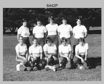
Photograph - Army’s 3rd Military District Inter-Service Softball Team, Victoria, 1981
This is a photograph of Army’s Inter-Service Softball Team that competed in the 3rd Military District, Victoria against Navy and Air Force taken on the 26th of February 1981. The competition was held from the 23rd to the 27th of February 1981. A note on the back of the photo indicated Army’s team came second. It is not known who the winning team was and where the competition was held.This is a photograph of Army’s Team that competed in the 3rd Military District Inter-Service Softball competition against Navy and Air Force, taken in an unknown location in Victoria on the 26th of February 1981. The black and white photo is on photographic paper and was scanned at 300 dpi. It is part of the Army Survey Regiment’s Collection. .1) - Photo, black and white, 1981. Back row L to R: PTE Karen Ball – DSU Broadmeadows, CPL Kay Melton – DSU Puckapunyal, SPR Scheryl Delforce – Army Survey Regiment Bendigo, WO2 Dizzy Dowsett – CARO, LT Jan McFarlane. Front row L to R: SPR Sharon Jones – Army Survey Regiment Bendigo, CPL Donna Sheldrick, CPL Di Chalmers – Army Survey Regiment Bendigo, PTE Karen ???, PTE Jackie Hubbard.Personnel and dates are identified on the back of the photo as well as on paper. royal australian survey corps, rasvy, army survey regiment, army svy regt, fortuna, asr -
 Greensborough Historical Society
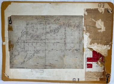
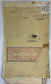
Poster - Planning Document, City of Heidelberg, Subdivision Plan # G 27, Greensborough and Diamond Creek, 1922 and 1963
Plan of Subdivisions in City of Heidelberg: Side 1: 2 plans, Parish of Keelbundoora: plan 1: Henry Street, Vermont Avenue, Lyell Street, Nell Street, McDowell Street, 1922. Plan 2: Henry Street, Nepean Street, Charles Street, 1922. Side 2: 2 plans Parish of Nillumbik, Portion 13: Plan 1: Diamond Creek Road, Delfin Crescent, Ridge Road, 1963. Plan 2: Kinglake Road, Eltham Road, 1963.An example of hard copy subdivision plans from the Greensborough area. Mainly from the Shire of Diamond Valley era (1964-1994).Plan (2 sided) mounted on heavy card. Contains 2 sheets pasted together.Stamped and handwritten Council permissions, dates and other details.subdivision plans, city of heidelberg -
 Greensborough Historical Society
Poster - Planning Document, Shire of Diamond Valley, Subdivision Plan # G 1, Watsonia, 1962 and 1976
Plan of Subdivisions in Shire of Diamond Valley: Side 1: subdivision of LP5406 bounded by Plenty Road, Greensborough Road, Meakin Avenue, Watsonia and includes Aqueduct Road, 1976. Side 2: 2 plans - Keelbundoora: Morwell Avenue and Grace Street; Nillumbik: Inglis Street and Chute Street Diamond Creek, 1962An example of hard copy subdivision plans from the Greensborough area. Mainly from the Shire of Diamond Valley era (1964-1994).Plan (2 sided) mounted on heavy card. Contains 2 sheets pasted together.Stamped and handwritten Council permissions, dates and other details. subdivision plans, diamond creek, shire of diamond valley -
 Greensborough Historical Society
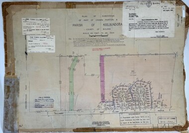
Poster - Planning Document, City of Heidelberg et al, Subdivision Plan # H 41 - Crown portion 8, Parish of Keelbundoora - Yallambie, and Crown Portion 9, Parish of Keelbundoora, 1922-1967
Planning Document: Subdivision Plan # H 41 Side 1, Crown portion 8, Parish of Keelbundoora - Yallambie Road, Allima Avenue, Koolya Court, Ekam Court (Jennings Estate). Side 2: Crown Portion 9, Parish of Keelbundoora consist of 5 small subdivision sheets: 1. Somers Avenue, Stewart Terrace, Toubay Street and Railway Place (no date); 2. Somers Avenue, Maxwell Street, Greensborough Road, 1924; 3. Heidelberg Avenue, Golf Avenue, St Andrews Avenue (no date); 4. Birdwood Avenue, May Street (no date); 5. Strathallan Road 1924.An example of hard copy subdivision plans from the Greensborough area. Mainly from the Shire of Diamond Valley era (1964-1994).Plan (2 sided) mounted on heavy card. Stamped and handwritten Council permissions, dates and other details.subdivision plans, city of heidelberg, yallambie, macleod, greensborough -
 Greensborough Historical Society
Poster - Planning Document, City of Heidelberg, Subdivision Plan # G 29 Part 1, Crown allotment 17, Greensborough, 1922
Plan of Subdivisions in City of Heidelberg: Parish of Keelbundoora: Crown allotment 17 - Warwick Road, Clydbank Street, Alexandra Street, 1922.An example of hard copy subdivision plans from the Greensborough area. Mainly from the Shire of Diamond Valley era (1964-1994).Plan (single sided) mounted on heavy card. Stamped and handwritten Council permissions, dates and other details.subdivision plans, city of heidelberg -
 Greensborough Historical Society
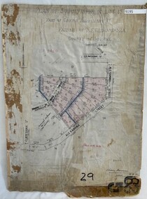
Poster - Planning Document, City of Heidelberg, Subdivision Plan # G 29 Part 2, Crown portion 16, Greensborough, 1951
Plan of Subdivisions in City of Heidelberg: Parish of Keelbundoora: Crown portion 16 - Daours Court and Devonshire Road, 1951.An example of hard copy subdivision plans from the Greensborough area. Mainly from the Shire of Diamond Valley era (1964-1994).Plan (single sided) mounted on heavy card. Stamped and handwritten Council permissions, dates and other details.subdivision plans, city of heidelberg -
 Greensborough Historical Society
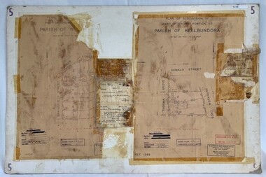
Poster - Planning Document, City of Heidelberg et al, Subdivision Plan # 5 - Crown Portion 17, Parish of Nillumbik, and Crown Portion18, Parish of Keelbundoora, 1925-1972
Subdivision Plan # 5 - Side 1: Crown portion [unknown - damaged], Parish of Nillumbik, Springfield Street, Turner Street Briar Hill,1963 amended 1972 and Crown Portion17, Parish of Keelbundoora: Thoona Grove, Donald Street. Paterson Crescent Greensborough, 1963 amended 1967. Side 2: Parish of Keelbundoora, Crown Portion 18: Boyd Street, Kempston Street Greensborough 1925; and Main Street Greensborough. An example of hard copy subdivision plans from the Greensborough area. Mainly from the Shire of Diamond Valley era (1964-1994).Plan (2 sided) mounted on heavy card. Stamped and handwritten Council permissions, dates and other details.subdivision plans, city of heidelberg, greensborough, briar hill, main street greensborough -
 Greensborough Historical Society
Poster - Planning Document, Shire of Diamond Valley et al, Subdivision Plan # 1018 - Parish of Nillumbik, County Bourke, Crown Allotment 4 Section 15, and Crown Allotment B Section 12, Eltham North, 1981-1982
Subdivision Plan # 1018 - Parish of Nillumbik, County Bourke, Crown Allotment 4 Section 15, and Crown Allotment B Section 12, Eltham North. This subdivision plan includes Ryans Road (also known as Government Road) and St Clems Street. The developer for this subdivision is Taunton Developments and the Surveyors are Fisher Cleeland Turner & Dwyer Vic, Surveyors and Engineers.An example of hard copy subdivision plans from the Greensborough area. Mainly from the Shire of Diamond Valley era (1964-1994).Plan (single sided) mounted on heavy card. Stamped and handwritten Council permissions, dates and other details. subdivision plans, shire of diamond valley, taunton developments -
 Greensborough Historical Society
Poster - Planning Document, Shire of Diamond Valley et al, Subdivision Plan # 1026 - Parish of Nillumbik, County Bourke, Crown Allotment B Section 12, Eltham North, 1981-1984
Subdivision Plan # 1026 - Parish of Nillumbik, County Bourke, Crown Allotment B Section 12, Eltham North. This subdivision plan includes Ryans Road (also known as Government Road) and St Clems Street. The developer for this subdivision is Taunton Developments and the Surveyors are Fisher Cleeland Turner & Dwyer Vic, Surveyors and Engineers.An example of hard copy subdivision plans from the Greensborough area. Mainly from the Shire of Diamond Valley era (1964-1994).Plan (single sided) mounted on heavy card. Stamped and handwritten Council permissions, dates and other details. subdivision plans, shire of diamond valley, taunton developments -
 Greensborough Historical Society
Poster - Planning Document, Shire of Diamond Valley et al, Subdivision Plan # 1044 - Parish of Nillumbik, County Bourke, Crown Allotment B Section 12, Eltham North, 1981-1987
Subdivision Plan # 1044 - Parish of Nillumbik, County Bourke, Crown Allotment B Section 12, Eltham North. This subdivision plan includes Weidlich Road and St Clems Street. The developer for this subdivision is Taunton Developments and the Surveyors are Fisher Cleeland Turner & Dwyer Vic, Surveyors and Engineers.An example of hard copy subdivision plans from the Greensborough area. Mainly from the Shire of Diamond Valley era (1964-1994).Plan (single sided) mounted on heavy card. Stamped and handwritten Council permissions, dates and other details. subdivision plans, shire of diamond valley, taunton developments -
 Greensborough Historical Society
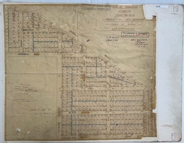
Poster - Planning Document, City of Heidelberg, Subdivision Plan # 19 - Parish of Keelbundoora, Crown Portion 16, Watsonia "Black's subdivision', 1924
Subdivision Plan # 19 - Parish of Keelbundoora, Crown Portion 16, Watsonia "Black's subdivision". This subdivision plan includes proposed street names which were later changed (e.g. Morwell Street (not Morwell Avenue) now called Greenwood Drive). Includes Lambourn Road, Black Street, Grace Street, Eden Avenue, High Street, Kenmare Street, Morwell Avenue, Greensborough Road, Mundy Street, Ladd Street.An example of hard copy subdivision plans from the Greensborough area. Mainly from the Shire of Diamond Valley era (1964-1994).Plan (single sided) mounted on heavy card. Stamped and handwritten Council permissions, dates and other details. subdivision plans, city of heidelberg, greensborough, main street greensborough, shire of heidelberg, watsonia, black family -
 Greensborough Historical Society
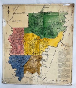
Poster - Map, City of Heidelberg, 1965c
Map of the City of Heidelberg showing municipal boundaries and Wards are coloured. Scale 20 chains to 1 inch.An example of hard copy plans from the 1960s. Mainly from the Shire of Diamond Valley era (1964-1994).Colour map, pasted on card and laminated.Stamped and handwritten Council permissions, dates and other details. city of heidelberg, heidelberg - maps, local government -
 Ringwood and District Historical Society
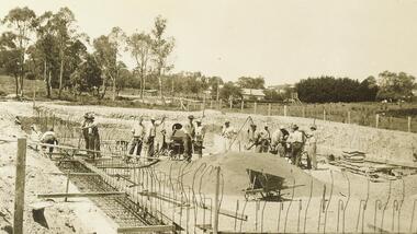
Photograph, Building the old Ringwood baths in Ringwood St. 1934
Black and white photograph See Item 3000 for newspaper articles with 1934 datesTyped below photograph, "Building the old Ringwood baths in Ringwood St, looking towards Warrandyte Rd. 1934." -
 Ringwood and District Historical Society
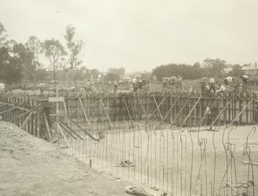
Photograph, Building old Ringwood swimming pool, 1934, Ringwood St
Black and white photograph See Item 3000 for newspaper articles with 1934 datesTyped below image, "Building old Ringwood swimming pool, 1934, Ringwood St.", looking Sth East. -
 National Vietnam Veterans Museum (NVVM)
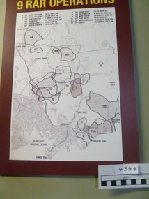
Poster - Poster, Information Board, 9 RAR Operations
Map of 9 RAR operations with a burgundy background. there is a list of operations and dates on the board9 rar, map of operations, poster, information board -
 Port Melbourne Historical & Preservation Society
Book - Port Melbourne Free Library, 1896/97
Free Library dates and Signatures 13/7/1896 to 22/7 1897.Titled Minute book on frontlocal government - town of port melbourne, port melbourne library, port melbourne free library, port melbourne town hall -
Tatura Irrigation & Wartime Camps Museum
Calender, Camp Calender, 1944
Made in Camp 3. Calender made in Camp 3 by Gudrun Gollong, with wood cut prints depicting camp life.A4 sized grey paper containing woodcut and calender dates for each month. -
 Melbourne Legacy
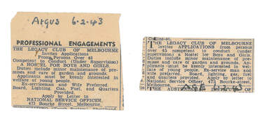
Newspaper - Document, article, Professional engagements, 06/02/1943
Two advertisements that invites applications from persons over 45 to run a hostel for Legacy. Applicants must be keenly interested in welfare of young people and were preferably an ex-serviceman and his wife. Legacy was in the process of setting up Holmbush as a hostel to care for the children of deceased servicemen and these are an indication of the type of skills and attributes they required. Holmbush was the first hostel for children that Legacy started and operated from April 1943. It was later renamed Blamey House after another hostel called Blamey House was closed. Melbourne Legacy ran three residences: Blamey House (purchased 1947) , Stanhope (purchased 1945) and Harelands (purchased 1950), to take care of children whose fathers were servicemen, and who may have been left orphans, or whose mother may have been unable to care for them herself. Harelands accommodated boys and girls under the age of 14, Blamey House looked after boys over 14, and Stanhope looked after girls over 14. The children were cared for until they were old enough to become independent.Shows the duties and preferred attributes required to run Holmbush as a residence for children.Newspaper cuttings of advertisement for the manager position at Holmbush, black type, handwritten dates.00349.1 Argus 6.2.43 00349.2 AGE 6.2.43residences, holmbush, staff -
 Queenscliffe Maritime Museum
Memorabilia - Couta Boat memorabilia; fuel ration tickets 1941
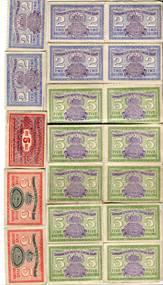
Petrol rationing was introduced in Australia in late 1940 and early 1941, but was not strictly enforced until 1942. The first ration tickets had a currency of six months. After that, issues were made every two months, to avoid forgeries and black market hoarding.A collection of ration tickets for fuel in various colours depicting volume and validity dates.fuel ration tickets, wwii, fishing -
University of Melbourne, Burnley Campus Archives
Plan, Landscape Construction Facility/Field Station Entry Development Proposal, 1997-1998
The same plan, coloured, drawn by Phil Tulk with different dates: 27.11.1997 and 18.05.1998.phil tulk, field station, landscape construction facility -
 Bendigo Historical Society Inc.
Document - RESIDENCE AREAS REGISTER - INDEX TO VOLUME 23, 1935 - 1936
Document: red and grey book, indexed to Volume 23. Dates 1935 - 1936.residence areas, bendigo, sandhurst, land sales, index -
 Surrey Hills Historical Society Collection
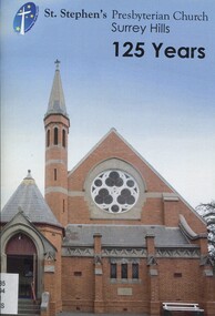
Book, St Stephen's Presbyterian Church Surrey Hills 125 years
This brief description of St. Stephen's Presbyterian church, Surrey Hills, on the corner of Canterbury and Warrigal Roads, Surrey Hills, dates back to 1887 when Surrey Hills was a settled emerging community. It documents the changes from then, including the land and buildings, their ministry, hymn books and bibles, church camps, mission work, PMWU, men's activities, outreach groups, multi-cultural groups until 2012.This brief description of St. Stephen's Presbyterian church, Surrey Hills, on the corner of Canterbury and Warrigal Roads, Surrey Hills, dates back to 1887 when Surrey Hills was a settled emerging community. It documents the changes from then, including the land and buildings, their ministry, hymn books and bibles, church camps, mission work, PMWU, men's activities, outreach groups, multi-cultural groups until 2012.(mr) j. k. blogg, 1887, surrey hills, (mr) (rev) john ewing, (mr) (rev) alexander mcdonald, (mr) (rev) frederick darling, surrey college, kleppers orchard, balmoral crescent, st. stephen's presbyterian church, uniting church, (mr) (rev.) david innes, (rev) w. howden, (mr) (rev) david bradshaw, churches, canterbury road, warrigal road -
 Ballarat Tramway Museum
Document - List, NSWGT - list of steam tram motors, 1950's
A 5 page typed (foolscap) listing of steam tram motors, NSWGT, Newcastle and Sydney, builders dates, renumbering, builder Nos. scrapping dates. stapled on side in 3 places. Pages numbered 1A, !. 2,3, and 4.Inscription "Return to Wal Jack"newcastle, sydney, nswgt, steam tram motors -
Surrey Hills Historical Society Collection
Work on paper - Vertical file, Athletics club
1. Athletic club – Surrey Hills: 6 notes from Boroondara Standard, various dates (2 pages). 2. Excerpts from Box Hill Reporter, various dates; Ken James research (18 pages). -
 Whitehorse Historical Society Inc.
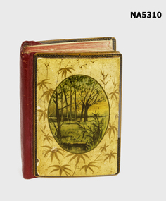
Book - Birthday Book, Unknown
Property of Jane Tyack, documenting birthdays of the Tyack family & friends alongside inspirational daily quotation. Bound book, with illustrated front cover. Bamboo panels back & front. Font illustration of bamboo leaves & forest scene on paper mache.birthday book, quotations, dates, family birthdays, friends birthdays -
 Falls Creek Historical Society
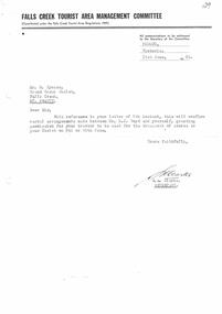
Letter - Permission Granted To Use Tractor For Transport Of Stores
Bob Hymans Collection Bob (Herman) Hymans (a former member of the Royal Netherlands Navy) was born in Bloemendaal, Holland on 30th September 1922. During World War II he fought against the Japanese in the Dutch East Indies (now Indonesia) and was imprisoned in Changi and on the Burma Railway. After gaining qualifications as a Ski Instructor, Bob arrived in Falls Creek in July 1950. Working as an Instructor and Supervisor at Bogong Lodge, Bob decided his future was in accommodation. He was successful in negotiating an indenture for land from the State Electricity Commission (SEC). It took Bob two years to build his Grand Coeur Chalet but, tragically, it was burned down in August 1961. Bob also built the first Chairlift in Australia. This was a single chairlift and the structure was built from wooden electricity poles. He was constantly full of new ideas and proposals for the village. Bob Hymans died on 7th July 2007. This Collection of documents and letters tells the story of Bob's endeavours to develop Falls Creek into the ski village it is today.This letter is significant because it reflects the relationship between Bob Hymans and the Management Committee.A brief letter from the Falls Creek Tourist Area Management Committee confirming permission for Bob Hymans to use his tractor for transport on two specific dates. The letter was issued after the dates requested, but was confirmation of a verbal arrangement.falls creek tourist area management committee, bob hymans -
Federation University Historical Collection
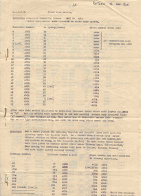
Booklet, University of Ballarat Council Sealing Register, 1994-2004, 1994-2004
Red hardcovered foolscap book listing dates and items sealed by University of Ballarat Council.university of ballarat council, university of ballarat, university of ballarat seal, legal, university seal -
 Bendigo Historical Society Inc.
Document - CENTRAL DEBORAH GOLD MINE - BOILER INSPECTION REPORTS
Hand written copies of boiler inspections and descriptions. Dates 1933, 1937, 1941and 1953.mine, gold, central deborah gold mine, central deborah gold mine, boiler inspectin reports -
 Bendigo Historical Society Inc.
Book - LOYAL DARLING LODGE
Loyal Darling Lodge cheque book butt. Dates range from 1890-93.bendigo, institutions, loyal darling lodge -
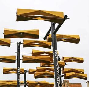 City of Ballarat
Artwork, other - Public Artwork, Aaron Robinson et al, Flow by Holly Grace and Aaron Robinson, 2014
Water is key to a thriving community and it is through the representation of water Flow enlivens the space at Bakery Hill. Historically ‘water races’ ran through the valleys of the Greater Ballarat area unearthing the minerals that forged prosperity and wealth. This water still flows today unearthing new possibilities for the community. Possibilities focusing on sustainability, ecology, health and prosperity. Flowing over the site a series of kinetic turbines flutter in the wind creating a contemporary water race. The interactive elements offer visual stimulation enticing people to connect with the artwork and in turn the surrounding spaces. Bakery Hill has great historical significance. It’s connection to the Eureka Stockade and the series of events that were to unfold during the 1850’s was to become the turning point in Australian political history. The placement of each turbine is to mirror a point of history in the timeline of events that occurred during the Eureka Stockade. The Water Race is a symbol of possibilities, the ones created by history and those of modern society. It is a visual timeline that can be read by traversing the site. The connecting turbines that flow and turn in sync are a representation of time passing and the interconnectedness of history with the community that surrounds it. The gateway to Bridge Mall is framed through the placement of each turbine allowing the sense of prosperity and wealth to flow through to the surrounding community. This gateway also references the significance of Bakery Hill reinvigorating the historical site by reconnecting it back to its town centre. The artwork is of aesthetic and historical significance to the people of BallaratTwelve steel turbines set on poles with dates attached and a large bronze 'timeline' plaqueFLOW/ Plotting the motion of Wind, Water, History and Time/ by Holly Grace and Aaron Robinson/ This site has great historical significance. It’s connection to the Eureka Stockade and the series of events that unfolded in the 1850’s was to become the turning point in Australian history. The placement of each turbine within this artwork mirrors a point of history in the events that led up to the Eureka Stockade. It is a visual timeline that can be read by traversing the site. The connecting turbines that flow and turn in sync are a representation of time passing. They are a symbol of the community’s connection to their history. 1851 June James Esmond makes the first discovery of gold in Victoria at Clunes./ 1st July The Port Phillip District separates from New South Wales and becomes the Colony of Victoria. It is still subject to British rule./ August Gold is discovered at Buninyong and at Golden Point, Ballarat. Lt-Governor La Trobe introduces the Gold Licence system in an attempt to reduce the colony’s debt./ 20th September First gold licences issued in Ballarat. / 1852 August/ Eureka Lead discovered on the Ballarat goldfields. December Charles La Trobe resigns as Lt-Governor but he is not relieved until 1854/ July – December/ Unrest builds on the various goldfields with protest meetings held in Bendigo and Castlemaine. Bendigo’s Red Ribbon Movement is active on the goldfields and the Bendigo Petition is presented to Lt-Governor./ December/ Charles Hotham is appointed Lt-Governor/ 1854 March/ A bill to extend the Elective Franchise is passed by the Legislative Council and sent to London for the assent of the British Parliament. 22nd June/ Lt-Governor Sir Charles Hotham arrives in Victoria. The colony faces mounting debt and Hotham orders weekly licence hunts in an attempt to increase income./ August/ Hotham is acclaimed during his visit to the Ballarat goldfield./ 13th September? Hotham orders twice-weekly licence hunts to further increase revenue./ September – October/ Miners are experiencing problems – no shafts bottomed on the Eureka Lead for five weeks./ 7th October/ James Scobie is murdered outside the Eureka Hotel. Many diggers believe that publican James Bentley is responsible./ 9th October/ At Scobie’s inquest, Bentley is acquitted, despite strong evidence of his guilt./ 10th October/ Father Smythe’s servant is beaten up by authorities and falsely arrested for not holding a licence./ 15th October/ Mass meeting of miners on Bakery Hill. Catholic miners meet after Mass. // 17th October/ A meeting of up to 10,000 Diggers is held near the Eureka Hotel to protest against Bentley’s acquittal. The meeting results in the burning of the hotel. Three diggers, Westerby, Fletcher and McIntyre, are arrested. Hotham dispatches 400 soldiers to Ballarat. 22nd October/ Another large meeting is held to address grievances. The Catholics send their leaders, Hayes, Kennedy and Manning to meet Rede. The Government Camp is under siege 11th November/ A public meeting on Bakery Hill results in the formal establishment of the Ballarat Reform League and adoption of the League’s proposals./ 21st November/ The enquiry into the Bentley affair is published. It recommends the dismissal of the judge and the establishment of a Royal Commission. 23rd November/ Westerby, Fletcher and McIntyre are convicted of burning the hotel. The Ballarat Reform League demands their release. 27th November/ A deputation from The Ballarat Reform League, including Humffray, Black and Kennedy, meet with Hotham to demand the release of the three prisoners. Hotham does not believe the diggers have the right to “demand anything”, Rede requests reinforcements in Ballarat. 28th November/ Miners attack the troop reinforcements and wagons passing near the Eureka diggings. A drummer boy is seriously wounded. 29th November/ A “Monster Meeting” attended by more than 10,000 diggers is held on Bakery Hill. The Southern Cross flag is flown for the first time. Peter Lalor addresses the miners and a number of diggers burn their licences. 30th November/ A licence hunt occurs in the morning at the order of Commissioner Rede. Another meeting of radical miners is held on Bakery Hill. Peter Lalor becomes leader of the diggers and calls for volunteers. Many diggers wear an oath to defend their rights and liberties under the Southern Cross flag. A number of diggers move to the Eureka Lead and start to erect a stockade. 3rd December In the early hours of Sunday morning 296 soldiers and police led by Captain Thomas proceed from the Government Camp to the Eureka Lead and attack the Stockade. 22 diggers and 7 military are officially listed as being killed. Many others are wounded. Approximately 120 diggers are arrested and marched to the Government Camp. 4th December/ Funeral of some of the fallen diggers and soldiers. Martial Law is proclaimed in Ballarat. Henry Seekamp, editor of the Ballarat Times is charged with seditious libel. 6th December/ Major General Sir Robert Nickle, commander-in-chief of the military forces in the Australian colonies, arrives in Ballarat. 9th December/ General Nickle repeals martial law. 14th December/ The Gold Fields Commission sits for the first time. 18th December/ The first Ballarat sitting of the Gold Fields Commission is held at Bath’s Hotel. 1855 23rd January/ Henry Seekamp is found guilt of sedition and sentenced to three months in prison. 22nd February/ The Eureka trials starts in Melbourne. February to March/ 13 prisoners are tried and acquitted amid great public rejoicing. 27th March Report of the Royal Commission recommends miners’ rights and significant reforms. 10th November/ Peter Lalor and John Basson Humffray are nominated for seats in the legislative Council. 31st December Sir Charles Hotham dies before his resignation takes effect. flow, aaron robinson, holly grace, public art, eureka stockade, bakery hill