Showing 1027 items matching "disasters"
-
 Flagstaff Hill Maritime Museum and Village
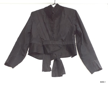
Clothing - Mourning Outfit, jacket, Late 19th to early-20th centuries
This Edwardian era mourning outfit was worn by a wealthy woman from the rural area of Willaura, southeast of the Grampians. It was inherited by the donor from his mother, who had purchased it from a clearing sale in the 1960s. The jacket has a peplum or flounce below the waistline, a fashion that was seen in the 1860s and is still around in the 1900s. The outfit represents the female mourning fashion and wardrobe from the late 19th to early 20th centuries. Such garments were a necessary inclusion as death occurred often to the young, due to illness, accidents and hard work - it was a regular part of life in rural Victoria. Mourning outfits were a part of a person’s wardrobe and often passed from one generation to the next. This particular outfit appears to have been adjusted at some stage to allow for a wider waistline. The original skirt may have been replaced by the one that is now part of this outfit; the skirt is all machine-sewn, unlike the jacket and petticoat. The fabric of the skirt may be silk or it could be a synthetic fibre such as artificial silk or rayon; both were available in the 1800s,but nylon wasn’t invented until the 1930s. This skirt has sunray pleating, which was advertised on skirts for sale in the 1890s, and 1909, and was part of a fashionable bridal gown train in the 1930s. The mourning of death was part of both family and community life, particularly in rural and remote areas. People were bonded through work, religion, disasters, tragedy and social activities, supporting one another. They came together from near and far on such an occasion, giving each other the care that was needed and showing respect for the member who had passed away.This three-piece silk Edwardian mourning outfit is significant historically for its connection with rural Victoria and the social and religious customs surrounding the death of a family or community member. The high-quality outfit is also significant for representing the financial management of the times, being tailored by a dressmaker for a person of means and then adjusted to fit at least one different-sized person. The black silk tailor-made jacket is one of three pieces of a ladies’ Edwardian mourning outfit. It has long sleeves, a stand-up collar trimmed with appliqued black crochet lace, and pleated sashes on the left and right sides from front to back fastened at the shoulder and waist. The jacket has a peplum or flounce below the waistline. The front of the jacket has brass hooks and fabric eye fastenings. The back of the jacket has two tails. The jacket is lined and the shoulders are padded. It has been machine sewn and finished with hand stitching. A white card is tied with a ribbon inside and has an inscription. The poplin skirt on the jacket has been cut up to the waist at the side seams. There is an attached card with an inscription, handwritten in ballpoint pen.“Jenny” and “Mrs Sheila Handscombe, Wallaura, Jenny”flagstaff hill maritime museum and village, warrnambool, shipwreck coast, edwardian era, tailor-made, dressmaker, mourning outfit, handmade garment, mourning dress, death mourning, sunray pleats, sunburst pleats, western district victoria, mourning jacket -
 Flagstaff Hill Maritime Museum and Village
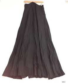
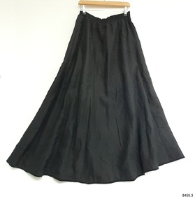
Clothing - Mourning Outfit, skirt, Late 19th to early-20th centuries
This Edwardian-era mourning outfit was worn by a wealthy woman from the rural area of Willaura, southeast of the Grampians. It was inherited by the donor from his mother, who had purchased it from a clearing sale in the 1960s. The jacket has a peplum or flounce below the waistline, a fashion that was seen in the 1860s and is still around in the 1900s. The outfit represents the female mourning fashion and wardrobe from the late 19th to early 20th centuries. Such garments were a necessary inclusion as death often occurred to the young, due to illness, accidents and hard work - it was a regular part of life in rural Victoria. Mourning outfits were part of a person’s wardrobe and often passed from one generation to the next. This particular outfit appears to have been adjusted at some stage to allow for a wider waistline. The original skirt may have been replaced by the one that is now part of this outfit; the skirt is all machine-sewn, unlike the jacket and petticoat. The fabric of the skirt may be silk or it could be a synthetic fibre such as artificial silk or rayon; both were available in the 1800s, but nylon wasn’t invented until the 1930s. This skirt has sunray pleating, which was advertised on skirts for sale in the 1890s, and 1909, and was part of a fashionable bridal gown train in the 1930s. The mourning of death was part of both family and community life, particularly in rural and remote areas. People were bonded through work, religion, disasters, tragedy and social activities, supporting one another. They came together from near and far on such an occasion, giving each other the care that was needed and showing respect for the member who had passed away.This three-piece silk Edwardian mourning outfit is significant historically for its connection with rural Victoria and the social and religious customs surrounding the death of a family or community member. The high-quality outfit is also significant for representing the financial management of the times, being tailored by a dressmaker for a person of means and then adjusted to fit at least one different-sized person. The full-length black silk tailor-made skirt is one of three pieces of a ladies’ Edwardian mourning outfit. The skirt is made from black silky fabric. The garment has only two seams; at the side closure and the centre back. The whole skirt has sunray pleats; narrow pleats at the waist that fan outwards towards the hem. The top of the skirt is finished with a waistband that is shaped as an upward V shape in the centre. The side seam is closed with four self-fabric buttons with silver metal backing. The shirt has been machine sewn.flagstaff hill maritime museum and village, warrnambool, shipwreck coast, edwardian era, tailor-made, dressmaker, mourning outfit, mourning dress, death mourning, sunray pleats, western district victoria, full-length skirt -
 Flagstaff Hill Maritime Museum and Village
Clothing - Mourning Outfit, petticoat, Late 19th to early-20th centuries
This Edwardian-era mourning outfit was worn by a wealthy woman from the rural area of Willaura, southeast of the Grampians. It was inherited by the donor from his mother, who had purchased it from a clearing sale in the 1960s. The jacket has a peplum or flounce below the waistline, a fashion that was seen in the 1860s and is still around in the 1900s. The outfit represents the female mourning fashion and wardrobe from the late 19th to early 20th centuries. Such garments were a necessary inclusion as death often occurred to the young, due to illness, accidents and hard work - it was a regular part of life in rural Victoria. Mourning outfits were part of a person’s wardrobe and often passed from one generation to the next. This particular outfit appears to have been adjusted at some stage to allow for a wider waistline. The original skirt may have been replaced by the one that is now part of this outfit; the skirt is all machine-sewn, unlike the jacket and petticoat. The fabric of the skirt may be silk or it could be a synthetic fibre such as artificial silk or rayon; both were available in the 1800s,but nylon wasn’t invented until the 1930s. This skirt has sunray pleating, which was advertised on skirts for sale in the 1890s, and 1909, and was part of a fashionable bridal gown train in the 1930s. The mourning of death was part of both family and community life, particularly in rural and remote areas. People were bonded through work, religion, disasters, tragedy and social activities, supporting one another. They came together from near and far on such an occasion, giving each other the care that was needed and showing respect for the member who had passed away.This three-piece silk Edwardian mourning outfit is significant historically for its connection with rural Victoria and the social and religious customs surrounding the death of a family or community member. The high-quality outfit is also significant for representing the financial management of the times, being tailored by a dressmaker for a person of means and then adjusted to fit at least one different-sized person. The full-length black silk tailor-made petticoat is one of three pieces of a ladies’ Edwardian mourning outfit. The petticoat is made from black silk lined with lightweight cotton. The petticoat and lining are constructed from eight panels each, brought together at the waist and gently gathered into the band. The back seam opening is fastened with brass hooks and fabric eyes. The lining has been reinforced with a heavier-weight hem. The hemline is finished with black velvet ribbon than encloses both the petticoat and lining. flagstaff hill maritime museum and village, warrnambool, shipwreck coast, edwardian era, tailor-made, dressmaker, mourning outfit, handmade garment, mourning dress, death mourning, sunray pleats, western district victoria, petticoat, undergarment, slip -
 Flagstaff Hill Maritime Museum and Village
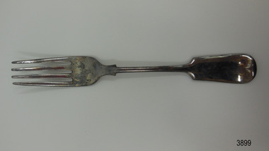
Domestic object - Fork, c. 1878
This fork was recovered from the wreck of the Loch Ard. It is the Old English design that has been very popular since the 19th century. It has been restored to resemble its original state prior to the disaster in 1878. The for was originally plated with silver, which is when a base metal such as nickel or nickel alloy with copper and/or zinc has been plated or coated with a thin layer of silver. Wear on the metal will cause the base metals to appear through the silver plating. Some manufacturers gave a warranty that the cutlery was ‘white throughout’ but didn’t necessarily say it was solid silver. LOCH ARD 1873-1878 – The Scottish-built clipper ship Loch Ard was bound for Melbourne in 1878 with 54 people on board. The mixed cargo it carried included items for the 1880 International Exhibition in Melbourne, one of which was the now famous Majorca ware Minton ‘Peacock’ statue. The Loch Ard was wrecked on June 1st when the ship crashed into Mutton Bird Island, east of Port Campbell. The only survivors were Tom Pearce, a crew member, and Eva Carmichael, a young passenger who was rescued by Pearce. The Gibsons, owners of nearby Glenample Homestead, cared for Tom, and for Eva who stayed longer before returning to Ireland. The wreck of the Loch Ard was discovered in 1967, before the introduction of the Victorian historic shipwreck legislation. In 1969 it was decided that all recovered material should be lodged with the Receiver of Wrecks. In 1980 Flagstaff Hill Maritime Museum Divers received a permit to recover artefacts from the wreck to safeguard them from looters. In 1982 the site was listed as a Historic Shipwreck, and the Maritime Archaeology Unit recovered loose artefact material. The fork is recognised as being historically significant as an example of cutlery either as part of the flatware service of the ship ‘Loch Ard’ or part of the ship’s cargo, imported for use in Colonial Victoria in the 19th to early 20th century. Flagstaff Hill’s collection of artefacts from LOCH ARD is significant for being one of the largest collections of artefacts from this shipwreck in Victoria. It is significant for its association with the shipwreck, which is on the Victorian Heritage Register (VHR S417). The collection is significant because of the relationship between the objects, as together they have a high potential to interpret the story of the LOCH ARD. The LOCH ARD collection is archaeologically significant as the remains of a large international passenger and cargo ship. The LOCH ARD collection is historically significant for representing aspects of Victoria’s shipping history and its potential to interpret sub-theme 1.5 of Victoria’s Framework of Historical Themes (living with natural processes). The collection is also historically significant for its association with the LOCH ARD, which was one of the worst and best known shipwrecks in Victoria’s history. Fork; silver plated. The fork is the Old English design and is embossed with several marks. it has recently been restored. Shipwreck artefact from the Loch Ard. 3 letters within an oval (- - S) 4 letters within circles (E) (P) (N) (S) 1 letter within a shield appears to be a [B] flagstaff hill, warrnambool, shipwrecked coast, flagstaff hill maritime museum, maritime museum, shipwreck coast, flagstaff hill maritime village, great ocean road, shipwreck artefact, loch ard, victoria, eva carmichael, tom pearce, cutlery, silver flatware, silver plate, antique, old english flatware pattern, eating utensil, fork, silverware, dining utensil -
 Flagstaff Hill Maritime Museum and Village
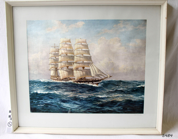
Print - Vessel, Sailing Ship, Loch Vennachar, 1875-1905
This framed print of the Loch Vennachar has been framed as a gift given by McPherson's Ltd. of Melbourne Sydney Brisbane Perth, as per the inscription below the print. Loch Vennachar made many journeys from Britain to Australia and was well-known in Australian ports. On one of its homeward-bound journeys from Australia, the ship sank in the River Thames. Its cargo included 850 tonnes of preserved canned rabbits from Warrnambool's Western Meat Preserving Company. The ship was raised and continued trading for another four years. On 14th June 1905, Loch Vennachar departed Glasgow for Adelaide and Melbourne. The last known sighting of it was on 6th September 1875 when overtaken by the SS Yongala; the captains exchanged the “all well” signals. After that, the ship disappeared with loss of all 27 lives, according to a list that was received by Fremantle through the English mail. The list indicated that there were no passengers on that voyage. Sadly, other Loch Line ships med with similar disasters. The list of lost crew on the Loch Vennachar included Thomas. W. Pearce, apprentice, Southampton. His father was Tom Pearce, one of the two survivors of the Loch Ard, wrecked in 1878. Also, Thomas’ grandfather, James Pearce, was the captain of SS Gothenburg at the time of her wrecking in 1875. Consequently, the wrecking of the Loch Vennachar and the Loc Sloy near the southwest point of Kangaroo Island, a lighthouse was erected, officially opening in June 1907. The northern headland of West Bay was named Vennachar Point in memory of the ship in 1908. The wreck was discovered in 1976 by divers from the Society for Underwater Historical Research, over seventy years after being lost off Kangaroo Island. The Loch Vennachar performed a significant role in Australia’s colonial trade, taking goods between Great Britain and Australia. These goods included locally preserved tinned rabbits processed at a factory in Warrnambool for overseas trade.Print of painting clipper ship Loch Vennachar. (aka Loch Vennacher, as spelled on this print). Print is under glass in white painted timber frame. The vessel was wrecked on Kangaroo Island September 1905 with the loss of all hands. There is an inscription below the print"Loch Vannacher" on right below print, "Compliments from McPherson's Ltd. Melbourne,Sydney, Brisbane, Perth" on left below printflagstaff hill, warrnambool, shipwrecked-coast, flagstaff-hill, flagstaff-hill-maritime-museum, maritime-museum, shipwreck-coast, flagstaff-hill-maritime-village, loch vennachar, loch vennacher, loch line ship, glasgow shipping co, mcpherson's ltd. melbourne sydney brisbane perth, loch vennachar image., kangaroo island shipwreck, 1905 shipwreck, mcpherson's ltd. melbourne sydney brisbane perth, canned rabbits, preserved rabbits, western meat preserving company -
 Bendigo Historical Society Inc.
Document - DRAINAGE PROBLEMS - INRUSH OF WATER AT THE VICTORIA QUARTZ
Two handwritten copies of a Bendigo Advertiser report 16/6/1910 Page 7. This is a longer version of 3600.14. It was thought that the rush of water was from a dam bursting in one of the other mines, but as the water showed no signs of slowing that theory was discarded. The temperature of the incoming water was much higher than the Victoria Quartz was accustomed to bail, and this circumstance is significent in view of the increased temperature of the water at the deep levels in the New Chum Railway. Some months ago, the water commenced to flow from the New Chum Railway workings into the New Shenandoah, which is the next mine north. The water rose so rapidly that a disaster was narrowly averted. The mines along the line were connected at different levels and with the cessation of bailing at the deep levels in the southern mines, it was only to be expected that the water would find its way north to the Victoria Quartz. The water raised from the operating mines under the direction of the New Chum Drainage Association, a yeart or two ago used to exceed six million gallons per month. At that time there were eight companies bailing water, and even then some of the plants, especially those at the deep mines, were severely taxed in coping with the water, and performing ordinary work. Since some mines had discontinued bailing, the water has been filling up extensive workings, and as was predicted in the ''Advertiser'' some time ago, the Victoria Quartz Company could not expect to succeed with its deep sinking project without making some special provision for raising the water, which ultimately would become a source of trouble. The Victoria Quartz Company was allotted a special grant of 10,000 pound to assist in sinking the shaft 1000 ft from the 4254 ft level. Under the conditions of the grant, the Company had to contribute half the cost of the sinking, and the raising of the water has also been an exensive item. For the present, all attention will be concentrated in lowering the water, and should the appliances prove unequal to the task the deep sinking scheme can only be accomplished by resorting to some comprehensive system of combating the water'. Document from Albert Richardson Collection of mining history.document, gold, drainage problems, drainage problems, inrush of water at the victoria quartz, bendigo advertiser 16/6/1910 page 7, mine reports 13/6/1910, victoria quartz, lansell's 180, mr stevens, mr w abraham, new chum & victoria mine, new chum railway, new shenandoah, new chum drainage association -
 City of Moorabbin Historical Society (Operating the Box Cottage Museum)
Kitchen Equipment, Bread Knife 'Clauss', c1900
Clauss Cutlery’s long and vivid history started in early 1880’s when John Clauss and his younger brother Henrie established Elyria Shear Works in Elyria, Ohio. At one time the company was the largest manufacturer of scissors and shears in the world and was acquired by Acme United Corporation in 2004. John and Henrie Clauss, of German origin, started Elyria Shear Works from a one-room building in Elyria, Ohio Together with five employees, they began manufacturing scissors, shears, straight razors and serrated kitchen knives In August 1887, the Company moved to Fremont, Ohio to be near an accessible, abundant supply of natural gas which had recently been discovered. 1889, disaster struck as the plant was completely destroyed by fire, In 4 months Clauss built a new plant and was back in full operation and changed the company’s name to Clauss Shear Company. 1919 Clauss Shear merged with Henkel Company, to become Henkel-Clauss Company. Henkel Company was founded in 1906 to manufacture manicure and pedicure files, knives, shears and razors. After World War II, Clauss was unable to compete with European firms producing household scissors and shifted its focus to industrial scissors. In 1967 Clauss was taken over by Alco Standard Corporation who integrated Clauss into its existing structure to manufacture tools for industrial niche markets. Clauss made surgical scissors for eye operations, heavy duty metal cutting shears, poultry shears for gutting chickens and specialty items such as anti-acid, anti-magnetic tweezers for the electronics industry. Clauss had approximately 100 employees and produced about $18 million in annual revenues in the late 1980s, but profits continued to decline. In 2004, Acme United Corporation acquired the Clauss inventory, trademarks and brand names from Alco Industries for approximately $500,000A large Bread Knife with scalloped / serrated edge and looped handle Front : CLAUSS Back : FREEMONT / OHIOcutlery, knives, clauss shear company, ohio, freemont, market gardeners, early settlers, moorabbin, cheltenham, -
 Flagstaff Hill Maritime Museum and Village
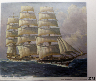
Print - Vessel, Sailing Ship, Loch Vennacher, 1875
This print shows an image of the three-masted iron clipper Loch Vennachar. The ship was built by Thomson’s on the Clyde under the Glasgow Shipping Co in 1875 and named after a Scottish lake, as were other ships in the Loch Line’s fleet. Loch Vennachar made many journeys from Britain to Australia and was well-known in Australian ports. On one of its homeward-bound journeys from Australia, the ship sank in the River Thames. Its cargo included 850 tonnes of preserved canned rabbits from Warrnambool's Western Meat Preserving Company. The ship was raised and continued trading for another four years. On 14th June 1905, Loch Vennachar departed Glasgow for Adelaide and Melbourne. The last known sighting of it was on 6th September 1875 when overtaken by the SS Yongala; the captains exchanged the “all well” signals. After that, the ship disappeared with loss of all 27 lives, according to a list that was received by Fremantle through the English mail. The list indicated that there were no passengers on that voyage. Sadly, other Loch Line ships med with similar disasters. The list of lost crew on the Loch Vennachar included Thomas. W. Pearce, apprentice, Southampton. His father was Tom Pearce, one of the two survivors of the Loch Ard, wrecked in 1878. Also, Thomas’ grandfather, James Pearce, was the captain of SS Gothenburg at the time of her wrecking in 1875. Consequently, the wrecking of the Loch Vennachar and the Loc Sloy near the southwest point of Kangaroo Island, a lighthouse was erected, officially opening in June 1907. The northern headland of West Bay was named Vennachar Point in memory of the ship in 1908. The wreck was discovered in 1976 by divers from the Society for Underwater Historical Research, over seventy years after being lost off Kangaroo Island.The Loch Vennachar performed a significant role in Australia’s colonial trade, taking goods between Great Britain and Australia. These goods included locally preserved tinned rabbits processed at a factory in Warrnambool for overseas trade.Coloured print from a painting of the sailing ship Loch Vennachar in full sail on the sea. The ship was built in 1875 and wrecked in 1905 off Kangaroo Island.Text under print "Loch Vennacher" and "from 1875 this beautiful 1,400 ton ship was well-known in Australian ports, contributing much to this country's prosperity. Foundered near Kangaroo Island, S.A., in 1905." flagstaff hill, warrnambool, shipwrecked-coast, flagstaff-hill, flagstaff-hill-maritime-museum, maritime-museum, shipwreck-coast, flagstaff-hill-maritime-village, loch vennachar, loch vennacher, loch line ship, glasgow shipping co, 1975 clipper ship, loch vennachar image., kangaroo island shipwreck, 1905 shipwreck, tinned rabbits, preserved rabbits, western meat preserving company, 1901, 1905 -
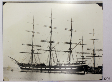 Flagstaff Hill Maritime Museum and Village
Photograph - Vessel, Sailing Ship, 1875-1905
This photograph is an image of the Loch Vennacher, taken while she is docked. The photograph is very similar to another in our collection taken by Fred. Kruger, a renowned Victorian photographer, between 1875-1905 and possibly in the Port of Melbourne. Loch Vennachar made many journeys from Britain to Australia and was well-known in Australian ports. On one of its homeward-bound journeys from Australia, the ship sank in the River Thames. Its cargo included 850 tonnes of preserved canned rabbits from Warrnambool's Western Meat Preserving Company. The ship was raised and continued trading for another four years. On 14th June 1905, Loch Vennachar departed Glasgow for Adelaide and Melbourne. The last known sighting of it was on 6th September 1875 when overtaken by the SS Yongala; the captains exchanged the “all well” signals. After that, the ship disappeared with loss of all 27 lives, according to a list that was received by Fremantle through the English mail. The list indicated that there were no passengers on that voyage. Sadly, other Loch Line ships med with similar disasters. The list of lost crew on the Loch Vennachar included Thomas. W. Pearce, apprentice, Southampton. His father was Tom Pearce, one of the two survivors of the Loch Ard, wrecked in 1878. Also, Thomas’ grandfather, James Pearce, was the captain of SS Gothenburg at the time of her wrecking in 1875. Consequently, the wrecking of the Loch Vennachar and the Loc Sloy near the southwest point of Kangaroo Island, a lighthouse was erected, officially opening in June 1907. The northern headland of West Bay was named Vennachar Point in memory of the ship in 1908. The wreck was discovered in 1976 by divers from the Society for Underwater Historical Research, over seventy years after being lost off Kangaroo Island.The Loch Vennachar performed a significant role in Australia’s colonial trade, taking goods between Great Britain and Australia. These goods included locally preserved tinned rabbits processed at a factory in Warrnambool for overseas trade.Black and white photograph of Loch Vennachar (aka Loch Vennacher) at a wharf. There are photo mounts in each corner. The vessel was was built in 1875 and wrecked on Kangaroo Island with the loss of all hands; she was last seen September 6th 1905 flagstaff hill, warrnambool, shipwrecked-coast, flagstaff-hill, flagstaff-hill-maritime-museum, maritime-museum, shipwreck-coast, flagstaff-hill-maritime-village, loch vennachar, loch vennacher, loch line ship, glasgow shipping co, 1875 clipper ship, loch vennachar image., kangaroo island shipwreck, 1905 shipwreck, photograph loch vennachar, fred kruger photographer, canned rabbits, preserved rabbits, western meat preserving company -
 Flagstaff Hill Maritime Museum and Village
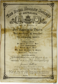
Award - Medal, James Patten, 18-041890
The Bronze Medal and Certificate of Merit of the Royal Humane Society of Australasia were awarded to James Patten for the bravery he displayed on 18th April 1890, and presented to him on 21st May 1890. The Royal Humane Society of Australasia was founded in 1874 with the aim to recognise those who risked their lives to save others and to assist those whose acts of bravery caused them or their surviving dependants to be disadvantaged in some way. Details of the incident were published in the Argus, Saturday 19 April 1890, page 11 - "FATAL BOATING ACCIDENT, (BY TELEGRAPH FROM OUR CORRESPONDENT.), WARRNAMBOOL, FRIDAY A fatal boating disaster occurred in Lady Bay this morning, the victim being Joseph Lowe, licensee of the Bay View Hotel, South Warrnambool. The deceased, in company with two lads named James Ferrier and James Patten, went out in a small dingy to shoot musk ducks. The water was perfectly smooth, and the party were tempted to proceed as far as the mouth of the Hopkins River. In their eagerness they neglected to keep clear of the breakers, and were presently carried in on the crest of a large wave, and the boat cap sized within a cable's length of the shore, precipitating the occupants into the water. Patten and Lowe stuck to the overturned boat, Ferrier striking out for the shore, which he reached in an exhausted state. In the meantime his companions had been washed off the boat, and were struggling in the breakers. Lowe was unable to swim, and Patten kept him afloat, at the same time making gallant attempts to get him ashore, but finally had to leave him to his fate. Ferrier, seeing Lowe's danger, undressed and swam out, but became exhausted. Ferrier and Patten were both found in a fainting condition by persons who saw the catastrophe from the jetty, and ran along the beach to render assistance. Attempts were subsequently made to rescue Lowe's body, which could be seen washing abort in the surf. These proved unsuccessful, and no hope is now entertained of recovering it. Lowe was a smart young man, 28 years of age, and unmarried. He was formerly bar-man at the Commercial Hotel here, having been engaged in Melbourne ..." This medal recognises the bravery of James Patten, a local citizen who risked his life to save the life of his friend Joseph Lowe whilst at sea and was recognised for this act by the Royal Humane Society of Australasia.Medal awarded to James Patten by the Royal Humane Society of Australasia for his bravery on18 April 1890 and presented to him on 21 May 1890. Bronze medal in hard black rectangular case. Lid and base have centre hinge and brass spring button catch. Case is padded and lined with blue silk and has a fitted hook. The round medal has a bronze bar with pin closure, dark blue, braided ribbon with brass swivel mount. The case has a gold embossed rectangular border on the lid and base. Embossed inscription on lid. The obverse shows a woman on the left in long robe placing a wreath on the head of a kneeling man at right, with the five stars of the Southern Cross constellation above his head. A motto is inscribed around the edge. The reverse has inscriptions around the edge, a wreath of two overlapping olive branches, and engraved text.OBVERSE: Embossed around "VIRTUTE PARATUM" REVERSE: Embossed on the medal around the edge "ROYAL HUMANE SOCIETY OF AUSTRALASIA INSTD. A.D. 1874", in the centre "AWARDED TO" Engraved in the centre "James Patten/ 18th April / 1890" CASE LID: "PRESENTED BY / THE ROYAL HUMANE SOCIETY / OF AUSTRALASIA / TO / JAS. PATTEN. / 21ST MAY 1890."flagstaff hill, warrnambool, flagstaff-hill, maritime museum, maritime village, shipwreck-coast, flagstaff hill maritime museum & village, bronze medal 1890, royal humane society of australasia, james patten, medal, australian award medal, commemorative medal, numismatics, life saving, lifesaving, rescue, bravery, drowning, joseph lowe, james ferrier, lady bay, hopkins river, boating accident, certificate of merit, north eastern bight -
 Forests Commission Retired Personnel Association (FCRPA)
Dugout sign, Post 1966
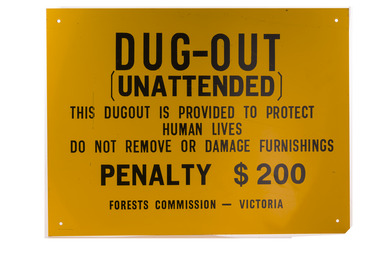
Considered in terms of both loss of property and loss of life, the Black Friday bushfires on 13 January 1939 were one of the worst disasters to have occurred in Australia and certainly the worst bushfire up to that time. The fires burnt 2 million hectares, 69 sawmills were destroyed, 71 people died, and several towns and sawmills were entirely obliterated. Among those killed were four men from the Commission The subsequent Royal Commission conducted by Judge Leonard Stretton has been described as one of the most significant inquiries in the history of Victorian public administration. Its recommendations led to sweeping changes. In addition to building dams and water points, the Stretton Royal Commission recommended expanding and controlling the use of bushfire dugouts at forest sawmills. Well-constructed dugouts had saved the lives of many sawmill workers and their families during the 1939 bushfires. But in some locations, they had proved fatal. Dugouts became mandatory for those few sawmills that remained in the forest after the 1939 fires. Many remote logging coupes and FCV roading camps also had dugouts. The local District Forester was required to make annual pre-season inspections of all dugouts on State forests and those within the Fire Protected Area (FPA). Some were built privately on private land. Most were primitive construction with a log or corrugated iron roof covered with earth. A hessian bag often hung at the entrance to keep the heat and smoke out. But they were dark and damp with snakes and other creepy crawlies often lurking inside. By 1940-41 there were 19 new dugouts constructed by the Commission and a further 128 by forest licensees. Ten years later there were 8 new Commission dugouts and 21 new ones built by other interests. By 1960-61 the rate of new builds was declining but the Commission still managed 103 dugouts while 127 were looked after by others. However, as the forest road network improved and gave all-weather access to modern two-wheel-drive vehicles the reliance on dugouts receded.Large metal sign that was positioned near forest dugoutsbushfire, forest signs, forests commission victoria (fcv) -
 Flagstaff Hill Maritime Museum and Village
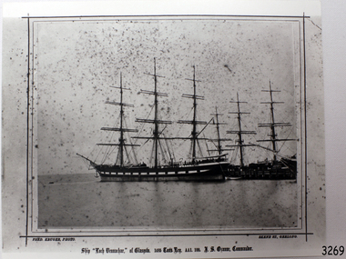
Photograph - Vessel, Sailing Ship, Fred. Kruger, Loch Vennachar of Glasgow, 1875-1888
This is a photographic image of the three-masted iron clipper Loch Vennachar created by photographer Fred Kruger of Geelong. Fred Kruger was born in Germany in 1831 and migrated to Victoria before his wife, who arrived in 1863. He began working in photography in the 1850s. He was internationally recognised for his work, which covered a variety of subjects. He settled in Geelong in later years, registering his studio in Skene St, Newtown. He passed away in February 1888. The National Gallery of Victoria now holds much of his work. Loch Vennachar: - Loch Vennachar made many journeys from Britain to Australia and was well-known in Australian ports. On one of its homeward-bound journeys from Australia, the ship sank in the River Thames. Its cargo included 850 tonnes of preserved canned rabbits from Warrnambool's Western Meat Preserving Company. The ship was raised and continued trading for another four years. On 14th June 1905, Loch Vennachar departed Glasgow for Adelaide and Melbourne. The last known sighting of it was on 6th September 1875 when overtaken by the SS Yongala; the captains exchanged the “all well” signals. After that, the ship disappeared with loss of all 27 lives, according to a list that was received by Fremantle through the English mail. The list indicated that there were no passengers on that voyage. Sadly, other Loch Line ships med with similar disasters. The list of lost crew on the Loch Vennachar included Thomas. W. Pearce, apprentice, Southampton. His father was Tom Pearce, one of the two survivors of the Loch Ard, wrecked in 1878. Also, Thomas’ grandfather, James Pearce, was the captain of SS Gothenburg at the time of her wrecking in 1875. Consequently, the wrecking of the Loch Vennachar and the Loc Sloy near the southwest point of Kangaroo Island, a lighthouse was erected, officially opening in June 1907. The northern headland of West Bay was named Vennachar Point in memory of the ship in 1908. The wreck was discovered in 1976 by divers from the Society for Underwater Historical Research, over seventy years after being lost off Kangaroo Island.The Loch Vennachar performed a significant role in Australia’s colonial trade, taking goods between Great Britain and Australia. These goods included locally preserved tinned rabbits processed at a factory in Warrnambool for overseas trade.Black and white photograph of the Loch Vennachar at the dock, without sails. (aka Loch Vennacher). Printed below photo "Loch Vennachar of Glasgow, 1485 Tons Reg. AA1 100. T.S. Ozanne, Comander" and "Fred Kruger Photo / Skene Street, Geelong" Printed below photo "Loch Vennachar of Glasgow, 1485 Tons Reg. AA1 100. T.S. Ozanne, Comander" and "Fred Kruger Photo / Skene Street, Geelong" flagstaff hill, warrnambool, shipwrecked-coast, flagstaff-hill, flagstaff-hill-maritime-museum, maritime-museum, shipwreck-coast, flagstaff-hill-maritime-village, loch vennachar, loch vennacher, loch line ship, glasgow shipping co, 1875 clipper ship, loch vennachar image., kangaroo island shipwreck, 1905 shipwreck, fred kruger photographer, photograph loch vennachar, preserved rabbits, canned rabbits, meat preserving company, western meat preserving company, 1901, 1905 -
 Mission to Seafarers Victoria
Journal (item) - Periodicals-Annual, Shiplovers' Society of Victoria, The Annual Dog Watch
This journal provides the reader with glimpses of the adventures and hardships of a seaman's life. Many of the stories are of sailing ships. PS Etona was built in 1898 at Milang, South Australia as a missionary church steamer for the Church of England. The Etona's run was from Mannum, South Australia, where she was based up to Renmark. As churches were built in river tower she was no longer required and in 1912 she was sold to Captain Arch Conner who used her as a fishing steamer at Boundary Bend for many years. She was brought out of retirement during the 1956 floods to do trips up the Murrumbidgee River. She was eventually bought by interest in Echuca and restoration was commenced in 1962. The Etona, now fully restored with her original steam engine can now be seen moored along side the historic wharf at Echuca.Contributes to our knowledge of the importance of shipping and places on record those stories of the sea which would otherwise be lost.Contents Foreword - G. F. Tilley - 5 The "Etona" - H. Vaughan Evans - 6 Editorial - Russell Hemingway - 11 The Old Lady Of The River - Captain J. Gaby - 19 "Takapuna" Interlude On A Moonless Night - E. Harper - 31 Maritime Museum of Tasmania - J. Miller - 34 The Confederate Raiders "Florida" and "Alabama" - A. R. Osmond - 36 "Ease After War . . . Doth Greatly Please" - Captain W. J. Cowling - 44 Mutiny At Sea - P. R. Wilkins - 49 War Service In The Indian Ocean - H. Mossman - 51 Cape Horn - Captain Eino Koivistoinen - 57 "Tragedy of Loss" - Jonathan john - 61 The End of The "Queen Elizabeth" - Bradley J. Newell - 62 London Could Cope With Him - Dr. Stanislaw Bernatt - 68 Three Ships Canals - N. S. Smith - 69 The Loss Of The "Eyoshi Maru" - Captain M. B. Glasier - 77 A Small Consignment But Valuable - J. B. Hodgson - 85 Lowden and The "Candida" - D. R. Rickard - 87 "Lauriston" Sails On - F. W. Rudd - 89 Confusion of Identities, "Young Australian", "Young Australia" and "Carl" - J. M. MacKenzie - 93 Rescue from "Clarissa", 1957 - Captain Leif Asklund - 97 Journey Home - Captain W. E. Eastoe - 100 Disaster At Blanket Bay - J. K. Loney - 104 The End Of The "Antiope" - Captain Bruce Bell - 106 The "Great Britain" - C. E. Bonwick - 108 Search The Coast To Shark Bay - Rear-Admiral Charles Adair U.S.N. - 110 The "Polly Woodside" Family - Rev. H. W. Coffey - 121 Book Reviews - 123sailing ships, steamships, shipping, seafaring life, shiplovers' society of victoria, dog watch, murray river, paddlesteamers, echuca, etona, ps etona -
 Flagstaff Hill Maritime Museum and Village
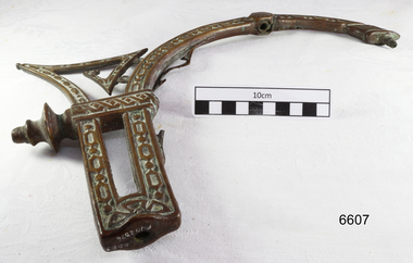
Functional object - Light Bracket, Before 1878
This pressed brass artefact is a highly decorative side bracket for distancing a gas lamp flame from the internal wall of a building. It is hollow and made of light gauge metal, with an innovative aesthetic design, but no internal piping to transport gas. It was recovered from the wreck of the LOCH ARD. There are similar artefacts in the Flagstaff Hill collection. The LOCH ARD left Gravesend (London) on 2 March 1878, bound for Melbourne, with a crew of 37, 17 passengers, and a diverse and valuable cargo of manufactured goods, luxury items, and refined metal. Some of the cargo was destined for display at Melbourne’s first International Exhibition in 1880. At 3 am, 1 June 1878, the ship was wrecked against the high limestone cliffs of Mutton Bird Island on Victoria’s south west coast near Port Campbell. Only two people survived the disaster — Tom Pearce, a male crew member, and Eva Carmichael, a female passenger. The cargo proved too difficult to salvage in the vessel’s exposed condition and was largely written off. The manifest of goods in the LOCH ARD’s holds included “Fittings gas (4 cases)”. The gas lighting of streets, public buildings, and the dwellings of wealthier private citizens was already well-advanced in the cities and major towns of the Australian colonies. In 1841 Sydney was the first to be gas-lit with 23 street lamps, 106 hotel lamps, and 200 private residences connected to the Darlinghurst “gasometer” by an underground network of metal pipes. “The dim days of oil and tallow are gone by!” pronounced one newspaper, flushed with civic pride. The 1850s Gold Rush promoted a similar attitude of confidence and affluence in the Colony of Victoria. In 1855 Melbourne was connected to its own system of subterranean gas pipes despite the same high rates of 25 shillings per 1000 cubic feet being charged, (reduced to 15 shillings in 1865 with cheaper sources of coal). By1858 Kyneton had its own gasworks to light the town (fuelled by eucalyptus leaves) and Geelong followed suit in 1860. Had the LOCH ARD reached its intended destination in 1878, it is probable that the 4 cases of brass gas light fittings on board would have found a ready market.The LOCH ARD shipwreck is of State significance — Victorian Heritage Register S417. The gas light bracket is an example of lamp fittings and plumbing from the late 19th century.A pressed brass lighting bracket recovered from the wreck of the LOCH ARD. It would be used for attaching, but simultaneously offsetting, a gas nozzle to a wall. Highly decorative in an unusually ‘modern’ or ‘art-deco’ style, with sweeping curves dissected by angular geometric pattern, and supporting a short, vertical bar with a gas nozzle on top. It is constructed of light gauge metal, with splitting along seams, and some delicate tracery is missing. Outer surface has been polished, removing sediment, but greenish oxidation remains in dents and joins. warrnambool, shipwreck coast, flagstaff hill, shipwrecked coast, flagstaff hill maritime village, flagstaff hill maritime museum, shipwreck artefact, maritime museum, gas lamps, gas lighting, gas works, brass fittings, gas pipes, loch ard, 1878 shipwreck, victorian affluence, colonial gas lighting -
 Flagstaff Hill Maritime Museum and Village
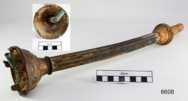
Functional object - Gas Fitting, Before 1878
The artefact is a short cross-section of part of a functional part of a brass fitting that suspended a gas lamp, providing structural support, and internally, supplying the gas for its ignition. It combines elegant design with the elements required for safe and efficient delivery of gas. It was recovered from the LOCH ARD shipwreck site. There are similar artefacts in the Flagstaff Hill collection. The LOCH ARD left Gravesend (London) on 2 March 1878, bound for Melbourne, with a crew of 37, 17 passengers, and a diverse and valuable cargo of manufactured goods, luxury items, and refined metal. Some of the cargo was intended for Melbourne’s first International Exhibition to be held in 1880. At 3 am, 1 June 1878, the ship was wrecked against the high limestone cliffs of Mutton Bird Island on Victoria’s south west coast near Port Campbell. Only two people survived the disaster — Tom Pearce, a male crew member, and Eva Carmichael, a female passenger. The cargo proved too difficult to salvage in the vessel’s exposed condition and was largely written off. The manifest of goods in the LOCH ARD’s holds included “Fittings gas (4 cases)”. The gas lighting of streets, public buildings, and the dwellings of wealthier private citizens, was already well advanced in the cities and major towns of the Australian colonies. In 1841 Sydney was the first to be gas lit with 23 street lamps, 106 hotel lamps, and 200 private residences connected to the Darlinghurst “gasometer” by an underground network of metal pipes. “The dim days of oil and tallow are gone by!” pronounced one newspaper, flushed with civic pride. The 1850s Gold Rush promoted a similar attitude of confidence and affluence in the Colony of Victoria. In 1855 Melbourne was connected to its own system of subterranean gas pipes despite the same high rates of 25 shillings per 1000 cubic feet being charged, (reduced to 15 shillings in 1865 with cheaper sources of coal). By1858 Kyneton had its own gasworks to light the town (fuelled by eucalyptus leaves) and Geelong followed suit in 1860. Had the LOCH ARD reached its intended destination in 1878, it is probable that the 4 cases of brass gas light fittings on board would have found a ready market.The gas fitting is significant for its association with the LOCH ARD shipwreck, which is of State significance and is listed on the Victorian Heritage Register S417. The fitting is an example of a late 19th-century plumbing and light fitting.A pressed brass gas light fitting, recovered from the wreck of the LOCH ARD. The elegant and functional fitting extends from an ornate 8cm diameter ceiling flange, and comprises two short lengths of fluted column pipe with a brass joiner that are severed (cut off) at the end. Within this decorative outer layer of 3cm diameter is a full length brass tube liner, which is in turn protecting a narrow 0.75cm copper gas pipe that also runs full length. The artefact is generally unrestored with reddish/cream sandstone concretion, but is in good condition.warrnambool, shipwreck coast, flagstaff hill, shipwrecked coast, flagstaff hill maritime village, flagstaff hill maritime museum, shipwreck artefact, maritime museum, gas lamps, gas lighting, gas works, brass fittings, gas pipes, loch ard, 1878 shipwreck, victorian affluence, colonial gas lighting -
 Flagstaff Hill Maritime Museum and Village
Award - Certificate of Merit, Royal Humane Society of Australia, James Patten, 21-05-1890
The Bronze Medal and Certificate of Merit of the Royal Humane Society of Australasia were awarded to James Patten for the bravery he displayed on 18th April 1890, and presented to him on 21st May 1890. The Royal Humane Society of Australasia was founded in 1874 with the aim to recognise those who risked their lives to save others and to assist those whose acts of bravery caused them or their surviving dependants to be disadvantaged in some way. The producers of the certificate were Fergusson & Mitchell, a Melbourne organisation established by 1858 that was an engraver, lithographer and printer. Details of the incident were published in the Argus, Saturday 19 April 1890, page 11 - "FATAL BOATING ACCIDENT, (BY TELEGRAPH FROM OUR CORRESPONDENT.), WARRNAMBOOL, FRIDAY A fatal boating disaster occurred in Lady Bay this morning, the victim being Joseph Lowe, licensee of the Bay View Hotel, South Warrnambool. The deceased, in company with two lads named James Ferrier and James Patten, went out in a small dingy to shoot musk ducks. The water was perfectly smooth, and the party were tempted to proceed as far as the mouth of the Hopkins River. In their eagerness they neglected to keep clear of the breakers, and were presently carried in on the crest of a large wave, and the boat cap sized within a cable's length of the shore, precipitating the occupants into the water. Patten and Lowe stuck to the overturned boat, Ferrier striking out for the shore, which he reached in an exhausted state. In the meantime his companions had been washed off the boat, and were struggling in the breakers. Lowe was unable to swim, and Patten kept him afloat, at the same time making gallant attempts to get him ashore, but finally had to leave him to his fate. Ferrier, seeing Lowe's danger, undressed and swam out, but became exhausted. Ferrier and Patten were both found in a fainting condition by persons who saw the catastrophe from the jetty, and ran along the beach to render assistance. Attempts were subsequently made to rescue Lowe's body, which could be seen washing abort in the surf. These proved unsuccessful, and no hope is now entertained of recovering it. Lowe was a smart young man, 28 years of age, and unmarried. He was formerly bar-man at the Commercial Hotel here, having been engaged in Melbourne...." The bronze medal and accompanying certificate of the Royal Humane Society of Australasia recognise the bravery of James Patten, a Warrnambool citizen who risked his life in the attempt to save the life of his friend Joseph Lowe.Certificate, cream paper, rectangular, decorative border and headings, printed and handwritten in pen and ink. Letterhead of The Royal Humane Society of Australasia. Awarded on 21st May 1890 to James Patten of Warrnambool. for his bravery on 18th April 1890.Print and writing includes - "The Royal Humane Society of Australia under the patronage of Her Majesty the Queen and their excellencies, the Governors of all the Australian Colonies and Fiji. At a general court of directors holden at the Offices of the Society Melbourne on the 21st day of May 1890, it was resolves that the courage and humanity displayed by James Patten, aged 20 years, labourer Warrnambool in attempting to rescue Joseph Lowe from drowning in the North Eastern bight of Lady Bay 18th April 1890. Call for the admiration of this court and justly, entitles him to the Bronze Medal of this society which is hereby awarded." Signatures [Secretary] and [President]flagstaff hill, warrnambool, flagstaff-hill, maritime museum, maritime village, shipwreck-coast, flagstaff hill maritime museum & village, bronze medal 1890, royal humane society of australasia, james patten, medal, australian award medal, commemorative medal, numismatics, life saving, lifesaving, rescue, bravery, drowning, joseph lowe, james ferrier, lady bay, hopkins river, boating accident, certificate of merit, lithograph, north eastern bight -
 Flagstaff Hill Maritime Museum and Village
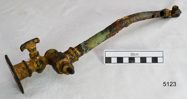
Functional object - Pipe Fitting, Before 1878
This artefact is a functional, non-decorative fitting that essentially transports gas from a wall attachment to a lamp. It is a brass and copper gas lamp fitting, designed to direct and control the flow of gas from a flanged wall fitting to an exit nozzle that was lit. It was raised from the LOCH ARD shipwreck site by Flagstaff Hill divers in 1972. Related pieces can be found in the Maritime Village collection. The LOCH ARD left Gravesend (London) on 2 March 1878, bound for Melbourne, with a crew of 37, 17 passengers, and a diverse and valuable cargo of manufactured goods, luxury items, and refined metal; some of which was to be on show at Melbourne’s first International Exhibition in 1880. At 3 am, 1 June 1878, the ship was wrecked against the high limestone cliffs of Mutton Bird Island on Victoria’s southwest coast near Port Campbell. Only two people survived the disaster — Tom Pearce, a male crew member, and Eva Carmichael, a female passenger. The cargo proved too difficult to salvage in the vessel’s exposed condition and was largely written off. The manifest of goods in the LOCH ARD’s holds included “Fittings gas (4 cases)”. The gas lighting of streets, public buildings, and the dwellings of wealthier private citizens were already well-advanced in the cities and major towns of the Australian colonies. In 1841 Sydney was the first to be gas-lit with 23 street lamps, 106 hotel lamps, and 200 private residences connected to the Darlinghurst “gasometer” by an underground network of metal pipes. “The dim days of oil and tallow are gone by!” pronounced one newspaper, flushed with civic pride. The 1850s Gold Rush promoted a similar attitude of confidence and affluence in the Colony of Victoria. In 1855 Melbourne was connected to its system of subterranean gas pipes despite the same high rates of 25 shillings per 1000 cubic feet being charged, (reduced to 15 shillings in 1865 with cheaper sources of coal). By1858 Kyneton had its gasworks to light the town (fuelled by eucalyptus leaves) and Geelong followed suit in 1860. Had the LOCH ARD reached its intended destination in 1878, the four cases of brass gas light fittings on board would probably have found a ready market.The LOCH ARD shipwreck is of State significance — Victorian Heritage Register S417. Flagstaff Hill’s collection of artefacts from LOCH ARD is significant for being one of the largest collections of artefacts from this shipwreck in Victoria. It is significant for its association with the shipwreck, which is on the Victorian Heritage Register (VHR S417). The collection is significant because of the relationship between the objects, as together they have a high potential to interpret the story of the LOCH ARD. The LOCH ARD collection is archaeologically significant as the remains of a large international passenger and cargo ship. The LOCH ARD collection is historically significant for representing aspects of Victoria’s shipping history and its potential to interpret sub-theme 1.5 of Victoria’s Framework of Historical Themes (living with natural processes). The collection is also historically significant for its association with the LOCH ARD, which was one of the worst and best known shipwrecks in Victoria’s history. This pipe is a gas lamp fitting. This extensively corroded fitting is made of brass and copper alloy. It comprises a 31 cm copper pipe of 1.5cm diameter which is connected to a 6.5cm diameter wall flange (via a flow tap and an adjustable swivel valve) at one end, and to a screw-in square coupling with a nozzle or gas jet at the other end. The copper pipe is dented and corroded and has three holes. The brass attachments are a more robust cast metal but the adjustable mechanisms are concreted into immobility by ocean sediment. No discernible maker’s marks. In unrestored but fair condition. The pipe with the fitting was recovered from the wreck of the LOCH ARD.flagstaff hill, warrnambool, shipwrecked coast, flagstaff hill maritime museum, maritime museum, shipwreck coast, flagstaff hill maritime village, great ocean road, loch line, loch ard, captain gibbs, eva carmichael, tom pearce, glenample station, mutton bird island, loch ard gorge, gas lamps, gas lighting, gas works, brass fittings, gas pipes, loch ard, 1878 shipwreck, victorian affluence, colonial gas lighting -
 Bendigo Historical Society Inc.
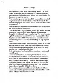
Document - PETER ELLIS COLLECTION: PETER ELLIS OBITUARY
3 A4 pages stapled together. Peter's Eulogy. We have lost a giant from the folklore scene. The huge crowd here today shows how much Peter meant to so many people. He has been my friend and band leader for the past twenty five years. Peter was the glue for our band. He planned the musical program in conjunction with the MCs. He listed all the tunes to be played and where to find them for those who read the dots. Peter was great fun to be around and I'd like to mention just a few things to show that. Peter was always an exuberant player. He would bounce around on his seat. This caused a near disaster at a drought relief benefit we were playing. The band was on a platform but our pianist Olive was at ground level as the piano could not fit. Peter bounced around so much his chair leg slipped and Peter ended up on top of poor Olive. Peter loved to entertain. He would play bones or swanee whistle at the drop of a hat. He would demonstrate the Charleston, can can or bunny hop for groups. For a big man he was very light on his feet. He loved to stand and circle his concertina, a memory I won't forget. I have to confess I have slept with Peter. Twice. The first time was at Port Fairy Folk Festival when the band slept in the nunnery at Koroit. Peter, Dean Swift and I shared a room. Peter's snoring was so bad Dean grabbed a blanket and a pillow and went to sleep in the mini bus. I went into another room but even with two closed doors found it difficult to sleep. As recently as this year's Illawarra Folk Festival Peter was in a tent in the performer's area. I noticed the tents either side quickly became vacant. The next time was in Canberra when Peter and I were at one end of a caravan and Mary Smith was at the other. I don't think poor Mary got much sleep that night. On another occasion in Canberra Peter was Half asleep in his van when another well known female performer (not from the band) came in and stripped off. She realised she was in the wrong van and grabbed her stuff and took off. She returned very red faced the next morning to collect her shoes. Peter maintained he saw nothing. One freezing cold night in Canberra Peter ad I had been at a terrific session in the bar. We had to support each other across the oval towards our caravan. Peter tried to straddle the fence and got stuck. There was a real Canberra frost on the fence and a sensitive part of Peter's anatomy was in grave danger of frost bite. Peter took an eternity to extricate himself. I couldn’t help him as I was laughing so much. We'll never forget making Harry McQueen's bull boar sausages at Nariel. Peter had already organised the meat and intestine casings from the butcher in Corryong. He was such an organiser and the sausages were brilliant. Peter was quirky. He always made a morning cuppa complete with tea cosy. It even left Martin Pearson speechless in the breakfast tent at Illawarra this year. Another example was when he sold his beloved FJ which is parked out the front today. As the new buyer drove off down the road Peter stood there playing 'Now is the hour' and 'wish me luck as you wave me goodbye' on his concertina. Peter loved a joke. He knew Shirley Andrews loathed the tune Danny boy so he played it in her hearing any chance he go. He even gave her a cd with a dozen different performers doing their versions of the song. We once played at the Rifle Brigade Oktoberfest and Peter was just a bit under the weather after being there for two days (the band got free drinks). The late night crowd was getting restless so Peter tried to shut them up by holding his finger up. They got more restless. Peter couldn’t understand it. 'it worked for Grummy Ross,' he wailed. It was the only time we ever over rode him and started playing without him. He wasn’t happy but disaster was averted. The dance club once had a reverse deb ball. Peter shave his beard, got his sister Robyn to make up his face and came to the ball in a lovely gown. It took ages for people to realise who it was.Margaret Hogan said the other night 'Peter let me see and do things I never would have done otherwise.' I think that is true of all of us in the band. We performed in major festivals regularly, travelled widely and had experiences such as playing at the opening of Melbourne Museum or State Parliament. Experience we'd never have had without Peter. I'm glad Peter didn’t suffer. He told me last Monday morning on my last visit he was in no pain. For that I am grateful. He passed away that night. He was taken far too young and has left a huge hole in all our lives. Personally I have lost a great mate, but then we can all say that. We'll miss you Dirty Pierre. John Williams.person, individual, peter ellis oam -
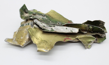 Mt Dandenong & District Historical Society Inc.
Object, Kyeema Wreckage Fragment, Pre 1938
The Kyeema airline crash took place on 25 October 1938 when the Australian National Airways Douglas DC-2 Kyeema, tail number VH-UYC, flying from Adelaide to Melbourne, commenced final approach to Essendon Airport through heavy fog and crashed into the western slopes of Mount Dandenong, killing all 18 on board instantly. There is strong evidence that the pilots were becoming unsure of their position. According to Macarthur Job's book, Disaster in the Dandenongs, the radio operator had requested the controller at Essendon give them a radio bearing. Essendon had acknowledged and told them to leave their transmitter on, but the signal stopped and no further contact was made. It is thought that this is the moment that Kyeema hit the mountain. There were 18 people on board the DC-2: 14 passengers, the captain, the first officer, an air hostess, and a cadet pilot who operated the radio during the flight. The victims were :— THE CREW. CAPTAIN A. C. D. WEBB, 32, pilot, married, of Essendon, Victoria. JUNIOR CAPTAIN ALAN J. STEEN, 25, pilot, married, of Essendon North, Victoria. ELVA JONES, 27, air hostess, single, of Toorak, Victoria. PHILIP D. PRING, about 20, cadet pilot attached to Australian National Airways' Aeronautics School, Sydney. PASSENGERS. CHARLES ALLAN SEYMOUR HAWKER, M.P., 44, single, of Adelaide. LEONARD SYDNEY ABRAHAMS, K.C., 51, married, barrister, of Sydney. SIDNEY HILL SMITH, 41, married, managing director of S. Smith and Son, of Yalumba, South Australia. ALFRED CECIL GAIN, 42, married, barrister, of Sydney. GORDON H. GODDARD, 30, single, accountant, of North Sydney. LANCELOT WILLIAM SHIRLEY, 27, single, solicitor, of Manly. JAMES IAN MASSIE, 25, single, solicitor, of Sydney. VAUGHAN PATE, 42, refrigeration cabinet manufacturer, married, of Unley, South Australia. THOMAS M. HARDY, 48, married, head of the firm of Thomas Hardy and Sons, vignerons, of Seacliff, South Australia. GEORGE WILLIAM LING, 72, of Kingswood, South Australia, former building inspector of the Municipal Tramways Trust, Adelaide. LOUIS HUGO GRAMP, 43, married, managing director of G. Gramp and Sons, Ltd., vignerons, Rowlands (sic) Flat, South Australia. Mrs. ELIZABETH MARY SCHRADER, 69, widow, of Adelaide. Mr. and Mrs. HANS L. GLOE, of Perth.Small section of the Kyeema DC-2 fuselage made up of 5 pieces of piece of twisted and torn aluminium riveted together. Marking can be seen in red but is indistinct. Aluminium has gold, silver and green colouring.kyeema, a webb, j steen, elva jones, philip pring, charles hawker, leonard abrahams, sidney hill smith, alfred gain, gordon goddard, lancelot shirley, james massie, vaughan pate, thomas hardy, george ling, hugo gramp, elizabeth schrader, mr hans gloe, mrs gloe -
 Flagstaff Hill Maritime Museum and Village
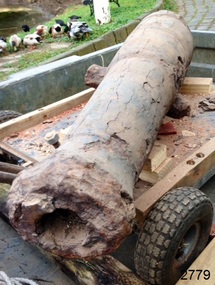
Weapon - Cannon, circa 1825
HISTORICAL INFORMATION In an article dated 26 March 1963, the Warrnambool Standard reported: “A cannon which has lain on the ocean floor since the barque, Children, was wrecked at Childer’s Cove on January 15, 1839, was raised by three Warrnambool skindivers at the week-end…The cannon, weighing about 750 lb. and 4-ft. 6-in. in length…is in excellent order considering the length of time it has remained under-water”. No conservation measures were taken at that time, other than chipping off the marine growth with hammers and cold chisels. The minutes for the 4 February 1974 meeting of the Flagstaff Hill Planning Board recorded that “a cannon recovered some time ago was lying in the garden of [one of the three original divers] and that it could be picked up at any time”. Peter Ronald, past Manager and Diver for Flagstaff Hill, notes that the CHILDREN cannon would have been recovered by the other divers around 1964. When the cannon came into care of Flagstaff Hill it was given basic conservation relevant to the time. (At the same meeting the Board was advised of the recovery of an anchor from the wreck of the CHILDREN by Flagstaff Hill divers (Peter Ronald, Colin Goodall and Gary Hayden, and Hank Howey and Andrew Coffee), and its interim relocation in the sea at the end of the Warrnambool Breakwater while awaiting conservation). The CHILDREN was owned by the pioneering Henty family of Portland. She was en route from Launceston to Adelaide, when she foundered in rough conditions at Childers Cove on 14 January 1839. The CHILDREN was a small three-masted barque, only 29 metres long and 254 tons weight, with 14 crew members and 24 passengers (including 9 children) on board. The ship was also carrying an awkwardly ballasted cargo of 1500 sheep, 8 bullocks, 7 horses, 5000 London house bricks, 6 whaling boats, and general trade goods. When the CHILDREN was driven into the limestone stack at the entrance to the cove, the seas smashed her into pieces within half an hour, and 16 lives were lost. The CHILDREN was an all-wooden ship, built in 1825 at Liverpool, and her shipwreck in 1839 is one of colonial Victoria’s earliest and most significant maritime disasters. There is little left to mark the tragedy on the seabed now, apart from some of the house bricks intended for the Henty’s Portland Bay settlement. Despite its poor condition, the CHILDREN’s signal cannon remains an important and interpretable record of her demise, (along with her anchor, the bottom half of her ship’s bell, and portions of a brass porthole - artefacts that are also in the Flagstaff Hill collection). In 2015 the CHILDREN cannon will undergo further conservation. (Conservation Management Plan for Victorian Guns and Cannon, South Western Victoria, May 2008, ref W/F/06) The shipwreck of the CHILDREN is of state significance — Victorian Heritage Register No. S116.A 1.3 metre iron 6pdr cannon recovered from the wreck of the CHILDREN. The shape of the cannon tapers from a thick round breech to a flared muzzle, with an 8 centimetre bore, and two side trunnions for pivoting on a wooden gun carriage. It was recovered from the shipwreck site of the CHILDREN by local divers in 1963. This small muzzle-loading signal cannon is in poor and unrestored condition. The cannon’s upper profile of smooth grey metal casing has corroded off, leaving an extensively oxidised rough red surface of crumbling iron. The bottom half of the cannon remains intact although the outer smooth casing also appears to be separating from the iron core of the barrel. Original grey casting is also missing from the breech and muzzle ends of the cannon. Corrosion and spalling of the upper surface layer of the cannon has removed the maker’s marks and specificationsflagstaff hill, warrnambool, shipwrecked coast, flagstaff hill maritime museum, maritime museum, shipwreck coast, flagstaff hill maritime village, great ocean road, the children, ship’s cannon, signal cannon, childers cove, 1839 shipwreck, conservation of marine artefactsm, shipwreck-coast, flagstaff-hill-maritime-village, cannon, 6pdr small bore cannon, children cannon, defence, children, shipwreck, 1839 -
 Federation University Historical Collection
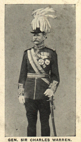
Photograph (black & White), General Sir Charles Warren - South Africa
General Sir Charles Warren was an officer in the British Royal Engineers. He was one of the earliest European archaeologists ofthe Holy Land. Much of his military service was spene in British South Africa. Previously he was police chief, the Head of the London Metropolitan Police during the Jack the Ripper murders. In 1876, the Colonial Office appointed him special commissioner to survey the boundary between Griqualand West and the Orange Free State. For this work he was made a Companion of the Order of St Michael and St George in 1877. He was appointed special commissioner to investigate "native questions" in Bechuanaland and commanded the Northern Border Expedition troops in quelling the rebellion there. In 1879 he became Administrator of Griqualand West. The town Warranton in the Northern Cape Province of South Africa is named after him. In 1882 the Admiralty sent him to Sinai to discover what had happened to Professor Edward Palmer's archaeological expedition. He discovered the members had been robbed and murdered, located their remains and brought their killers to justice. For this he was created a Knight Commander of the Order of St Michael and St George in 1883 , also Knight of Justice of the Order of St John of Jerusalem and in 1884 elected a Fellow of the Royal Society. In 1884 Warren was sent as HM Special Commissioner to command a military expedition to Bechuanaland, to assert British sovereignty in the face of encroachments from Germany and the Transvaal and to suppress the Boer freebooter states of Stellaland and Goshen, which were backed by the Transvaal and were stealing land and cattle from the local Tswana tribes. This became known as the Warren Expedition and achieved its aims without bloodshed. Warren was recalled and in 1885 was made Knight Grand Cross ofthe Order of St Michael and St George. In 1885 Warren stood for election for Parliament but lost the vote. In 1886 he was appointed Commissioner of Police of the Metropolis following Sir Edmund Henderson's resignation. Criticised continually for his decisions and actions he resigned in November 1888. Prior to this time he was appointed Knight Commander of the Order of the Bath, January 1888. On the outbreak of the Boer War in 1899 he returned to service and commanded the 5th Division of the South African Field Force. In January 1990, Warren bungled the second attempted relief of Ladysmith at Tugela River. At the Battle of Spion Kop, January 1990 he had operational command and his failure of judgement, delay and indecision despite his superior forces culminated in the disaster. It has been said that Warren was "perhaps the worst" of the British generals in the Boer War and certainly the most "preposterous". Redvers Buller in a letter to his wife described him as "a duffer", responsible for him losing him "a great chance". Warren was recalled to Britain in August 1900 and never again commanded troops in the field. Individual image from photographed poster of tobacco and cigarette cards.holy land, sir charles warren, british royal engineers, archaeologist, british south africa, london metropolitan police, jack the ripper, colonial office, commissioner, griqualand west, orange free state, companion of the order of st michael and st george, bechuanaland, northern border expedition, warrenton, sinai, professor edward palmer, knight commander of the order of st michael and st george, knight of justice of the order of st johnof jerusalem, fellow of the royal society, knight grand cross of the order of st michael and st george, boer war, redvers buller, knight commander of the order of the bath -
 Stawell Historical Society Inc
Archive, Red Cross Records, 1939 - 2004
2 Archive Boxes: Archive Box 18 contains: BAG 1 1 Red Cross First Aid Group. Black Folder 1954 - 1968 Exams 1 Grey Cover July 1944 to April 1945 (Minutes). Group to Disband & Join Red Cross and become Stawell Red Cross Emergency Company. 1 Red Cover - Red Cross Service Company Annual & General Meeting Minutes July 1970 to 1 September 1989. March & September 1978 Meetings abandoned due to insufficient persons attending. 21 September 1989 Meeting called to finalise all Accounts & distribute equipment. BAG 2 1 Plastic Sleeve: Contains 1 X Loose sheets of Miscellaneous Information. 1 Green cover Shell Exercise book - Miscellaneous Information. 1 The Great Blood Bank Evolution with Blood Donor Book Mark. 1 X3 Exercise Books: Monthly List of Donors. 1 Green Cover Shell Exercise Book Aug 1960 - Feb 1968 1 Green Cover Shell Excerise Book April 1968 - July 1979 1 Angle Striped Cover Student Excercise Book Spet - 1979 - March 1982. BAG 3 Blood Bank: Blood Donors & Voluntary Staff at "Blood Takes" 1962 - 1989 1. Blue and White Dimond COver Exercise book: Sept. 1964 - June 1968 1. Blue and White Check with Green Border Embassy Exercise Book: July 1968 - June 1973. 1. Blue Dimond Cover Exercise Book. Aug 1973 - Mar. 1983 1. Red Bound Bound Blue Book. Aug 1with Blood Bank Sticker: April 1983 - June 1989. BAG 4 1 X Bank Statements BAG 5 1. Plastic Bag: 2 Junior Red Cross First Aid Booklets. 1. Grey Cover, Red bound Disaster Times Register & Catering Register. 1. Gordon Exercise Book. Brown Cover Bool Disaster Times & Catering Registers 1984--1988 ( 2 Entries) BAG 6 1. Plastic Sleeve: Assorted Newspaper cuttings, Photos, cerftifcates 3 X Plastic Scapbooks 1961 Mid 1990's BAG 7 1 Plastic Sleeve: Red Cross Recollections Cassette Tape Made By Mrs Rene Hall, Mrs AliceBurton, Mrs Mill Walker, Mrs Jean Hughes; recorded by Elizabeth and2 hand written recollections my Mrs Jean Hughes and Mrs Ivy Newman. 1 Blue Cover Invicta Reservoir Esercise book: Distributing Book: List of Materials and wool supplied to members & What They Made for solders. 1939 - 9/06/1943. 1: Australian Red Cross Knitting Book. 1. Australian Red Cross Victorian Division Pyjamas etc. 1. Small Book Tennis Tournament 1939 with Photocopy of 2 Newspaper Cuttings. BAG 8 1 Plastic Sleeve: 6 News Sheets. 1. Branch Management Book 1940 1. Unit Information Handbook 1985 1 Treasurer's Handbook 1997 1 Office Bearer's Handbook.' 1999 *1 . Stawell Unit Award & Commendation in green folder 1985. 1. Roll of Article from Stawell Times 1,9,1999' 1 Cardboard around wrap for Pewter Wien Goblet sold as a Fundraiser 1. Pewter Bell donated for meeting by Annie N=Neil, and engraved as the Annie Neil Bell 1. Blue Covered book: Study of Red Cross Services ( Stawell Branch) 1939 - 1945 By Christina Joy. * Calico Cloth with Australian Red Cross These were attached to Garments owned by Red Cross. e.g. Short Gowns used at Blood Bank Had one on the Pocket. Archive Bos 19 BAG 1 1 Mottled Black over Red bound. Mon Oct 2 1939 Public Meeting called to form branch in Stawell. Committee meeting to Aug 1946 Page 281. Pages282 - 283 Minutes of Special Meeting: Feb 1942 June 1940 Aug. 1940 2. Public Meeting called to reform the Red Cross Emergency Service 29/07/1942 to 20/03/1970 BAG 2 1: The Original Subscription Book 1939-1940 2: Annual Roll Call Books 1941 1: Gordon Exercise book - Memberships 1941/42 1942/43 2: Membership Rolls: 1944/45 - 1950/51 Membership Rolls 1952/52 - 1959/1960. 1: Red bound Mottled Grey Cover Book - Memberships 1942 - 1968 Sundry Entries 1: Blue Cover Roll Call 1975 - 2002 1: Striped Cover Roll Call 1991 - 2005 1: Membership Subscriptions 2002 - 2004 1 Yellow Cover Office Bearers and Committee Members BAG 3 1 Treasurer's Cash Book 1939 - 1943 1 Receipts & Expenditure 1939 - 1943 1 Red Cover Receipts and Expenditure 1965/66 - 1983 1 Red Bound Receipts and Expenditure 1989 1993 1 Green Cover Receipts & Expenditure 1994 -2003 1 Red and Black Cover Receipts & Expenditire 1995 - 2004 1 White Cash Book 2004 BAG 4 1 Red & Grey Marble cover Red Cross Committe Meeting May 1947 - Oct 1955 2 Special Meeting Minutes: Feb 1951 Nov 1951 1 Brown Bound Minute Book Red Cross Committe Meeting Nov 1955 - Feb 1963 Special Meeting November 1960 1 Red Bound Account Book Used as Minutes March 1963 - Sept 1970. BAG 5 1 Red Bound Black book: Annual Meeting Book 1942- 1989 1 Red Mottled Cover Book Annual Meeting Book 1990 - 2004 BAG 6 1 Red Cover Book: Oct 1970 - June 1978 1 Red Mottled Cover Book: July 1978 - Nov 1987 1 Red Mottled Cover Book July 1996 - May 2004 Tray Cloth with Red Cross Identification Tag Stitched on. (Donated by Graeme McDonough Aug 2010) stawell -
 Eltham District Historical Society Inc
Photograph, Upper Yarra Dam, Spring Tour, 22 Oct 1995, 22/10/1995
EXPLORING THE UPPER YARRA (Newsletter No. 105, November 1995, by Bettina Woodburn) We enjoyed the Spring Excursion, this year "Exploring the Upper Yarra" - in spite of the constant rain and the countryside under the cloud cover, especially in the valleys, being mainly shiny shades of green. The occasional fields of buttercups, clumps of arum lilies and splendid rhododendron and other flowering bushes became very special. The Cobb and Co coach was warm and a cosy retreat as we zig-zagged on the highways and byways to glimpse the Yarra River, upstream and down, its secret places, and particularly the many bridges. Russell excelled as 'Poet Laureate', reading from Dacre Smyth's book. This 1979 publication includes paintings of all the bridges along the river with poems and brief descriptions of each one. Some of the bridges are in out of the way places and are not very well known. We looked forward to hearing the poetry as much as seeing the ' constructions'…Big Pat (was he short or tall, lean or fat? He did win the two hundred pound reward for discovering gold and had the creek named after him), about the 'Eddies'?, and the disliked 'meccano' bridge in Warburton, etc. etc. The hot roast lunch in the old Reefton Hotel was also most welcome. It was easy to imagine it peopled by miners and early settlers. Starting by crossing the new (1974) concrete bridge at Warrandyte we headed through Wonga Park with views to the Christmas Hills and to the escarpment of the Yering Gorge, which causes flood waters to back up through the Yarra Glen plain, so avoiding disasters downstream. At the end of a long driveway we found the wooden, privately owned Henley Bridge (1935 after the 1934 floods). This facilitates access to different parts of Henley Farm and to Lilydale. Everard Park, named after Blanche Shallard's father, a State Member for 17 years, below the Highway Yarra crossing was in need of care. It is 10 miles from Yarra Glen by road but, as "Yarra Marra” canoeists well know, 32 winding miles down by water. After more delightful countryside scenes we joined the Warburton Highway at Woori Yallock. From the old Railway Station at Launching Place the Centennial Trail for walkers, cyclists and ' horse riders has replaced the rails. The line from Lilydale was opened in 1901, and the last diesel freight train ran to Warburton in 1965. It continued to rain as we had morning tea in Warburton in a shelter between footbridges. From here we continued upstream past the Bridge to O'Shannasy Lodge and Reservoir, Starvation Creek, and the Peninsular tunnel (miners dug it as at Pound Bend) which we visited (scrambling down those steps!) on our return after lunch. Our furthermost point was the Upper Yarra Dam Reserve (and vast catchment area). Finished in 1957 after ten years work and 100 years after Yan Yean, it supplies much of Melbourne's water. After crossing the 30m Launching Place Bridge to the Eltham side of the Yarra and Healesville, we saw in the distance the Yarra Glen Timber Trestle Bridge over the river flats "the longest for years in the land it was said!" Harry's dream of "better weather over the Divide" unfortunately didn't come true, but I'm sure we 36 members will retain happy memories of a day that was wet and green and filled with Bridges. Bettina Woodburn - October 1995 Record of the Society's history of activities - Spring 1995 excursionColour photographshire of eltham historical society, activities, upper yarra dam, henley bridge -
 Eltham District Historical Society Inc
Photograph, Upper Yarra Dam, Spring Tour, 22 Oct 1995, 22/10/1995
EXPLORING THE UPPER YARRA (Newsletter No. 105, November 1995, by Bettina Woodburn) We enjoyed the Spring Excursion, this year "Exploring the Upper Yarra" - in spite of the constant rain and the countryside under the cloud cover, especially in the valleys, being mainly shiny shades of green. The occasional fields of buttercups, clumps of arum lilies and splendid rhododendron and other flowering bushes became very special. The Cobb and Co coach was warm and a cosy retreat as we zig-zagged on the highways and byways to glimpse the Yarra River, upstream and down, its secret places, and particularly the many bridges. Russell excelled as 'Poet Laureate', reading from Dacre Smyth's book. This 1979 publication includes paintings of all the bridges along the river with poems and brief descriptions of each one. Some of the bridges are in out of the way places and are not very well known. We looked forward to hearing the poetry as much as seeing the ' constructions'…Big Pat (was he short or tall, lean or fat? He did win the two hundred pound reward for discovering gold and had the creek named after him), about the 'Eddies'?, and the disliked 'meccano' bridge in Warburton, etc. etc. The hot roast lunch in the old Reefton Hotel was also most welcome. It was easy to imagine it peopled by miners and early settlers. Starting by crossing the new (1974) concrete bridge at Warrandyte we headed through Wonga Park with views to the Christmas Hills and to the escarpment of the Yering Gorge, which causes flood waters to back up through the Yarra Glen plain, so avoiding disasters downstream. At the end of a long driveway we found the wooden, privately owned Henley Bridge (1935 after the 1934 floods). This facilitates access to different parts of Henley Farm and to Lilydale. Everard Park, named after Blanche Shallard's father, a State Member for 17 years, below the Highway Yarra crossing was in need of care. It is 10 miles from Yarra Glen by road but, as "Yarra Marra” canoeists well know, 32 winding miles down by water. After more delightful countryside scenes we joined the Warburton Highway at Woori Yallock. From the old Railway Station at Launching Place the Centennial Trail for walkers, cyclists and ' horse riders has replaced the rails. The line from Lilydale was opened in 1901, and the last diesel freight train ran to Warburton in 1965. It continued to rain as we had morning tea in Warburton in a shelter between footbridges. From here we continued upstream past the Bridge to O'Shannasy Lodge and Reservoir, Starvation Creek, and the Peninsular tunnel (miners dug it as at Pound Bend) which we visited (scrambling down those steps!) on our return after lunch. Our furthermost point was the Upper Yarra Dam Reserve (and vast catchment area). Finished in 1957 after ten years work and 100 years after Yan Yean, it supplies much of Melbourne's water. After crossing the 30m Launching Place Bridge to the Eltham side of the Yarra and Healesville, we saw in the distance the Yarra Glen Timber Trestle Bridge over the river flats "the longest for years in the land it was said!" Harry's dream of "better weather over the Divide" unfortunately didn't come true, but I'm sure we 36 members will retain happy memories of a day that was wet and green and filled with Bridges. Bettina Woodburn - October 1995 Record of the Society's history of activities - Spring 1995 excursionRoll of 35mm colour negative film, 3 stripsKodak Gold 200-4shire of eltham historical society, activities, upper yarra dam, henley bridge -
 Eltham District Historical Society Inc
Photograph, Upper Yarra Dam, Spring Tour, 22 Oct 1995, 22/10/1995
EXPLORING THE UPPER YARRA (Newsletter No. 105, November 1995, by Bettina Woodburn) We enjoyed the Spring Excursion, this year "Exploring the Upper Yarra" - in spite of the constant rain and the countryside under the cloud cover, especially in the valleys, being mainly shiny shades of green. The occasional fields of buttercups, clumps of arum lilies and splendid rhododendron and other flowering bushes became very special. The Cobb and Co coach was warm and a cosy retreat as we zig-zagged on the highways and byways to glimpse the Yarra River, upstream and down, its secret places, and particularly the many bridges. Russell excelled as 'Poet Laureate', reading from Dacre Smyth's book. This 1979 publication includes paintings of all the bridges along the river with poems and brief descriptions of each one. Some of the bridges are in out of the way places and are not very well known. We looked forward to hearing the poetry as much as seeing the ' constructions'…Big Pat (was he short or tall, lean or fat? He did win the two hundred pound reward for discovering gold and had the creek named after him), about the 'Eddies'?, and the disliked 'meccano' bridge in Warburton, etc. etc. The hot roast lunch in the old Reefton Hotel was also most welcome. It was easy to imagine it peopled by miners and early settlers. Starting by crossing the new (1974) concrete bridge at Warrandyte we headed through Wonga Park with views to the Christmas Hills and to the escarpment of the Yering Gorge, which causes flood waters to back up through the Yarra Glen plain, so avoiding disasters downstream. At the end of a long driveway we found the wooden, privately owned Henley Bridge (1935 after the 1934 floods). This facilitates access to different parts of Henley Farm and to Lilydale. Everard Park, named after Blanche Shallard's father, a State Member for 17 years, below the Highway Yarra crossing was in need of care. It is 10 miles from Yarra Glen by road but, as "Yarra Marra” canoeists well know, 32 winding miles down by water. After more delightful countryside scenes we joined the Warburton Highway at Woori Yallock. From the old Railway Station at Launching Place the Centennial Trail for walkers, cyclists and ' horse riders has replaced the rails. The line from Lilydale was opened in 1901, and the last diesel freight train ran to Warburton in 1965. It continued to rain as we had morning tea in Warburton in a shelter between footbridges. From here we continued upstream past the Bridge to O'Shannasy Lodge and Reservoir, Starvation Creek, and the Peninsular tunnel (miners dug it as at Pound Bend) which we visited (scrambling down those steps!) on our return after lunch. Our furthermost point was the Upper Yarra Dam Reserve (and vast catchment area). Finished in 1957 after ten years work and 100 years after Yan Yean, it supplies much of Melbourne's water. After crossing the 30m Launching Place Bridge to the Eltham side of the Yarra and Healesville, we saw in the distance the Yarra Glen Timber Trestle Bridge over the river flats "the longest for years in the land it was said!" Harry's dream of "better weather over the Divide" unfortunately didn't come true, but I'm sure we 36 members will retain happy memories of a day that was wet and green and filled with Bridges. Bettina Woodburn - October 1995 Record of the Society's history of activities - Spring 1995 excursionRoll of 35mm colour negative film, 2 stripsKodak Gold 100-4shire of eltham historical society, activities, upper yarra dam, henley bridge