Showing 391 items
matching elevation
-
 Melbourne Tram Museum
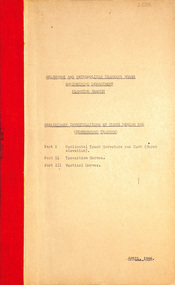
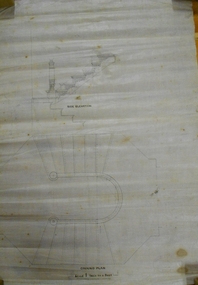
Document - Report, Melbourne & Metropolitan Tramways Board (MMTB), "Preliminary investigation of curve design for Underground tramways", Apr. 1966
Report - Foolscap 16 pages typed carbon copy including drawings, with card covers and a red binding strip titled - dated April 1966. Part 1 - Horizontal track curvature and cant (super elevation) Part 2 - Transition curves Part 3 - Vertical curvesIn top left hand corner "Lees" in penciltrams, tramways, trackwork, melbourne, underground tramways -
 Orbost & District Historical Society
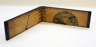
clinometer rule, mid 19th -earl 20th century
This clinometer, is a hand-held optical scientific instrument used in surveying to measure vertical angles. It is used to measure the angle of elevation from the ground in a right-angled triangle. It may have been used by a surveyor or a forester to measure the height of tall things where you couldn't possibly reach to the top of e.g. flag poles, buildings or trees.This item is an example of an early hand held measuring instrument.. Today the use of electronic sensors is an important component in the design and function of the clinometers.A rectangular wooden folding measuring instrument. the panels are brass framed. Inside is a brass semi-protractorgraduated 90-0-90' with index arm pointeran dwith a graduated edge in inches. Outside is a temperature conversion scale,Troughton & Simms, LONDONscientific-instrument measurement clinometer -
 Warrnambool and District Historical Society Inc.
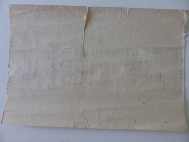
Document, Drawing of church of Christ Warrnambool, Mid 20th century
These are plans for proposed additions to the Church of Christ in Warrnambool. The date of the drawings and the maker of the plans are unknown. The additions do not appear to have been built. The Church of Christ in Warrnambool was founded in 1875 after a meeting at the Warrnambool Temperance Hall. The building in Spence Street Warrnambool was erected in 1884 at a cost of £1600 and officially opened in 1885. This church was sold and in 2000 the congregation moved to a new building at 186 Raglan Parade (called Gateway Church of Christ).These plans are of some interest as being part of the history of a Warrnambool church – the Church of Christ Warrnambool. These are two rough drawings on cream-coloured paper showing proposed additions to the Church of Christ in Warrnambool. The drawings are in pencil and include the front elevation plan and the first floor plan. The captions are in capital letters. Both pages have tattered edges and are torn across the middle and the pages are stained in places.‘Rough drawing suggested additions for Church of Christ Warrnambool’ ‘Suggested additions for Church of Christ Warrnambool’ church of christ warrnambool, gateway church of christ, history of warrnambool -
 Bendigo Historical Society Inc.
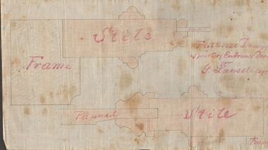
Document - MARKS COLLECTION: DRAWING ENTRANCE DOOR FOR G. LANSELL
Plan drawn on waxed paper. Written on plan 'Full size Drawing of part of entrance door for G. Lansell, Esq' Plan shows line drawings of side elevations of Frame, Stile, Pelmet, Stile, Frame. On bottom of plan purple ink stamp 'Vahland & Getzschmann, Architects, Sandhurst'.Vahland & Getzschmann, Architects, Sandhurst.bendigo, house, fortuna villa -
 Bendigo Historical Society Inc.
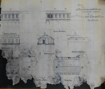
Document - MARKS COLLECTION: PLAN FOR ALTERATIONS AND ADDITIONS TO FORTUNA
Copy of plan: Written on top RH corner of plan 'plan for alteration and additions to the private residence of Geo Lansell Sandhurst' Plan shows western, southern, and eastern elevations, plus roof plan. Bottom section of plan damaged. On bottom of plan '1/8 inch to one foot.'buildings, house, fortuna villa -
 University of Melbourne, Burnley Campus Archives
Plan, Richmond Primary School 'Prep Garden', 1994
(1) Coloured Section Elevation and Detail Suggestion by Frances Saunders August 1994. (2) Coloured Preliminary Plan, Landscape Graphics by Rachel Dann dated 16.8.94. Scale 1:50. (3) Site Analysis & Inventory. Scale 1:50. (4) 2 copies, 1 coloured, Section Elevations by N. Herzberg. Scale 1:50. (5) Coloured plan, Secret Garden by Julie Tydens p3 of 3 dated 22.8.94. Scale 1:50. (6) Coloured Preliminary Plan by Jacinta Chong Sheet 3 of 3 dated 22 Aug 1994. Scale 1:100. (7) 2 tracing paper and 1 paper Site Plan drawn by JK. Scale 1:50 and 1:100. (8) Coloured Section Elevation for Landscape Graphics by Rachel Dann dated 22.08.1994. Scale 1:50. (9) Coloured Preliminary Plan dated August 1994 by Frances Saunders. Scale 1:100. (10) Preliminary Plan Sheet No 3 of 3 dated 18.08.1994 by Ian Porterfrances saunders, rachel dann, julie tydens, jacinta chong, ian porter, richmond primary school, gardens, jill kellow -
 Bendigo Military Museum
Print - PRINT, FRAMED, WW1, Reader's Digest (Australia) Pty Limited, 2015
From information Book - "Readers Digest'/ Gallipoli/ 25th April 1915 - 9th January 1916/ Centenary Commemorative Prints." Collection of 20 prints. Refer Cat No. 7300.Framed print. Print - colour print on paper. MAP ANZAC - map scale 1:10,000 elevations in feet. Depicts the line of Australian and New Zealand Front Trenches. Intended as a working document. Frame - Black plastic framing with glass front and MDF board backing with adhered black paper.Details below print - in black ink. "GERALD R. CAMPBELL Anzac: Map of Gallipoli Peninsula, 1916"framed accessories, prints, ww1, gallipoli, centenary -
 Bendigo Military Museum
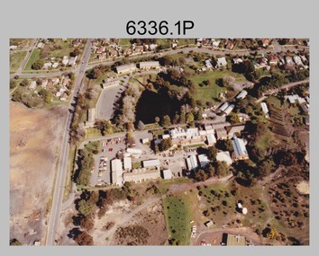
Photograph - Army Survey Regiment aerial photos, Fortuna, Bendigo, c1990
This is a set of two aerial photographs of the Army Survey Regiment, Fortuna, Bendigo taken in c1990. These photos are indicative of a series of 23 aerial photos in the collection taken from multiple angles and elevations. It is possible the photographs were taken from a hot air balloon. The approximate date of the photos is based on the existence of the new printing building - Wazgoose Hall and the new records building.This is a set of two aerial photographs of the Army Survey Regiment, Fortuna, Bendigo taken circa 1990. Colour photographs are on photographic paper and scanned at 300 dpi. They are part of the Army Survey Regiment’s Collection. .1) to .2) - Photo, colour, c1990. Army Survey Regiment aerial photos.royal australian survey corps, rasvy, army survey regiment, army svy regt, fortuna, asr -
 Bendigo Historical Society Inc.
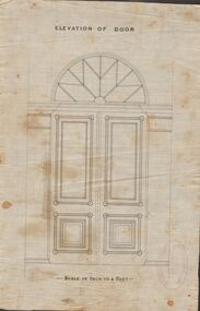
Document - MARKS COLLECTION: DRAWING FOR ELEVATION OF DOOR
Drawn on waxed paper. On top of plan 'Elevation of Door' printed in black ink, on bottom 'Scale an inch to a foot'. Plan shows double doors, arched window above. Contained in items from Fortuna Villa, although not marked as such. On bottom of plan purple ink stamp 'Vahland & Getzschmann, Architects, Sandhurst'.Vahland & Getzschmann, Architects, Sandhurst.bendigo, house, fortuna villa -
 Bendigo Historical Society Inc.
Plan - Bendigo East State School Plans 1915
A photocopy of a hand drawn coloured plan of Bendigo East State School No. 3893 dated 24th April 1915 showing various elevations and sections. Written on the plan are the names Joseph William Fairbanks (building contactor) and J. Hudspeth. The sum of 1097 pounds is also written on the plans. Gemma Starr Collectionbendigo east state school, bendigo schools, gemma starr collection, 1915 bendigo east state school, school plan, joseph william fairbanks -
 Melbourne Tram Museum
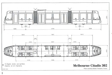
Drawing, Transit Australia Publishing, "Melbourne Citadis 302", Nov. 2001
Drawing of the produced by Transit Australia, November 2001 of the Citadis 302 tramcar by Alstom Transport France. Side and end elevations and floor plans with leading dimensions. .1 - "Siemens Combino Three Section Tram (Melbourne Class D1)" .2 - "Siemens Combino Three Section Tram (Melbourne Class D1"trams, tramways, drawings, tramcars, c class, tramcar design -
 Bendigo Military Museum
Administrative record - Joint Committee for the exchange of Information on ADP within the RASvy Corps, Activities Jun- Dec 1985, Army Survey Regiment, December 1985
Automated Computer Processing (ADP) was instrumental to the successful operation of the Royal Australian Survey Corps Mapping capability and production. This paper describes elements of the ADP with a comprehensive description of each. They Include, PDP 11/70 Memory, Map Stock Control System, Digital Terrain Elevation Data, Digital Terrain Model Package, ASMAPS, ASTIS, Reflectance Hill Shading, Aerial Triangulation and Terrain Analysis.Two page paper report about Automated Data Processing, unstapledHand annotated "Folio 74" in top right hand cornerroyal australian survey corps, rasvy, fortuna, army survey regiment, army svy regt, asr -
 Falls Creek Historical Society
Photograph - Road Under Ski Run at Falls Creek, 1960
This ski run was built for the 1960 Australian Downhill Championships conducted at Falls Creek. It may have been built in conjunction with the SEC. This crossing was just below the Falls Creek Resort entrance. It had a vertical elevation of approximately 1,500 feet. The building pictured is a former SEC building which became the "Galleon" Ski Club and was later know as Cooroona. To the right is the Bowna Ski Club.This image is significant because it captures a structure created for the 1960 Australian Downhill Championships held at Falls Creek.Image of a road passing under a downhill ski run at Falls Creek. A building is visible on the left of the photo.On sign above road: SKI RUN CROSSING / DOWNHILL RACING COURSE1960 australian downhill championships, downhill ski run falls creek -
 Melbourne Tram Museum
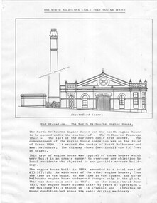
Drawing - North Melbourne Engine House, Jack Cranston
Drawing shows the North Melbourne cable tram engine house in Abbotsford St at Queensberry St, North Melbourne. Shows the elevation to Abbotsford St and the plan of the engine house showing the cable or rope layout and its function. Has notes on the engine house itself and costs etc. It operated from March 1890 to June 1935. Compiled by Jack Cranston for his book on cable trams.Yields information about the North Melbourne Engine house.Set of two printed quarto sheets.tramways, cable trams, engine houses, north melbourne, abbotsford st., queensberry st -
 Bendigo Historical Society Inc.
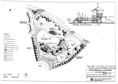
Document - LONG GULLY HISTORY GROUP COLLECTION: CHUM RESERVE LONG GULLY
Copy of a plan of the Chum Reserve, Long Gully, dated September 1998. The plan between Derwent Drive and Dyason Court show play area, trees, swings, fire pit, tree house and grassy area. There is also a plan of the tree house - South East Elevation. Drawn by Mary Jeavons Landscape Architects.bendigo, history, long gully history group, the long gully history group - chum reserve long gully, shared action long gully community house, city of greater bendigo, mary jeavons landscape architects -
 Ballarat Tramway Museum
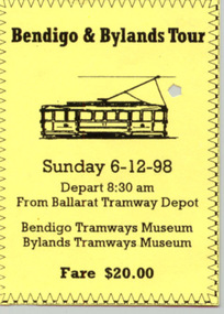
Ephemera - Ticket/s, Anita Bagley, BTM - Bendigo - Bylands Tour - 6/12/1998, Dec. 1998
Paper ticket printed onto light yellow paper with decorative border for the Ballarat Tramway Museum social group tour to Bendigo and Bylands tramway museums on 6/12/1998. Has a sketch of No. 11, side on elevation. Gives date, fare, departure time. Has been punched or cancelled by the trolley pole.trams, tramways, ticket, ballarat, bylands, bendigo -
 Melbourne Tram Museum
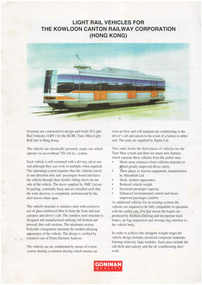
Pamphlet, Goninan & Co, "Light Rail Vehicles for the Kowloon Canton Railway Corporation (Hong Kong)", c1997
Pamphlet - A4, full colour two sided titled "Light Rail Vehicles for the Kowloon Canton Railway Corporation (Hong Kong)", giving details including dimensions and a side elevation of the 20 vehicles built for the KCRC Tuen Mun Light Rail line in Hong Kong. Published by Goninan, built in Newcastle, Hamiltontrams, tramways, hong kong, new trams, goninan & co., specification -
 Montmorency/Eltham RSL Sub Branch
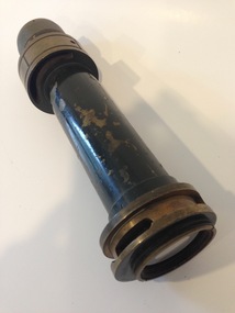
Equipment - Sighting Telescope (component part)
Appears to be part of sighting telescope for artillery. Further ID information has been sought from various sources, in including the Royal Australian Artillery History Company. The RAAHC have been most cooperative and interested in attempting to identify the equipment of which this item is a part, but with no firm details on its use or history at the time of cataloguing. Detailed communication between RAAHC and MERSL are available from the latter.Off-centre ring part way along barrel has engravings for elevation (?), ranging from 57 to 69 (see 4th picture above). Actual numbers engraved are 57 63 69, with small engravings to mark each degree between these intervals. -
Federation University Historical Collection
Plan, New Engineering Building for Ballarat School of Mines, 1939, 13/06/1939
.1) West and South Elevations .2) East and North Elecation and floor plan .3) Sections E-F, M-N, O-P, G-H, Z (Excavations and retaining walls) .4) Site plan and details of Retaining Walls .5) Excavations and retaining walls .6) Site Plan and retaining walls chief architect, ballarat school of mines, saw-tooth, engineering, architectural drawing -
 Bendigo Historical Society Inc.
Plan - MARKS COLLECTION: PLAN ALBERT PARK SERPENTINE FOR G. LANSELL
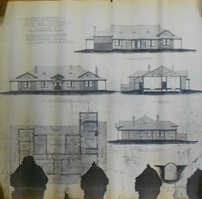
Copy of plan written on top LH corner: Proposed Homestead Albert Park Serpentine for H. Lansell Esq. Scale eight feet to one inch. W. Beebe & G.D. Garvin Architects, late W. Beebe, Mitchell St. Bendigo. Plan shows front, back and side elevation with floor plan for residence.buildings, house, albert park serpentine -
 Hume City Civic Collection
Photograph
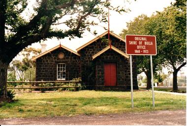
The former bluestone Bulla Shire Hall building was constructed in 1867 and remained the centre of local government until the early 20th century when the administration was moved to Sunbury. In the 1990's the Alister Clark Rose Garden was established in the surrounding grounds. The garden is open to the public all the year round. In 1999 the rose garden was officially opened.A coloured photograph of the front elevation of the original Shire of Bulla offices. It is a bluestone building, double fronted with a pitched roof on both wings and above the porch. The woodwork trims have been painted in cream and red. The double wooden front door is painted red. The sign outside the building indicates the former function of the building and its importance.ORIGINAL/SHIRE OF BULLA/OFFICE/1868-1923shire of bulla, council chambers, rose gardens, rose growing, bulla township, roses, clark, alistair, george evans collection -
 Kew Historical Society Inc
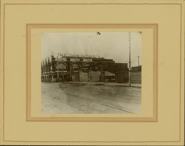
Photograph - Railway level crossing in Glenferrie Road, Glenferrie, E.J. Dower, 1912-13
One of a series of photographs, taken by Edgar James Dower in the second decade of the twentieth century. Born and raised in Olinda, his family later moved to Surrey Hills. He worked as an adult as a clerk in the city office of the Metropolitan Gas Company, and in his role as a 'collector', he was able to photograph scenes including the construction of tramlines and associated buildings in Kew, Hawthorn, Camberwell and Surrey Hills. Later he established a real estate agency with his brother - the E.J. Dower Real Estate Agency, Dandenong Office.The image is an historically significant record of the development of transport infrastructure which was used to connect Victorians in the first two decades of the twentieth century. This development resulted from increases in population and the consequent extension of Melbourne's suburbs. The photographs, both individually and collectively, richly detail the labour of workers and the tools and machinery used to create and extend Melbourne's public transport network in the years preceding and during World War 1.Digital copy of an original mounted photograph showing the old railway crossing in Glenferrie Road, Hawthorn. The removal of the train level crossing and the elevation of the rail line above the road was designed to enable the laying of tram tracks along Glenferrie Road. The buildings to the right of the photo were being demolished to allow for this. "The Don Store" is immediately behind the crossing.Annotated verso: "1912 / Demolishing shops near Glenferrie Railway Station, just prior to the regrading of line to camberwell / Taken by E.J. Dower 1912"theme --- travelling by tram, theme -- connecting victorians by transport and communications, glenferrie railway station, glenferrie road -- hawthorn (vic.), railways -- hawthorn -
Surrey Hills Historical Society Collection
Planning report, City of Boroondara, City of Boroondara planning report re 171 Union Road, Surrey Hills, 19/07/2004
171 Union Road was part of the Thomas Zeplin estate. It originally had a Victorian house on it built by the Zeplin family. This was leased by Dr Percy Liddle and then Dr James Landells Blakie. Dr Blakie purchased land diagonally opposite at 174 Union Road and had a purpose-built home / surgery constructed. Later the site was occupied by COR then a BP petrol station.A detailed proposal regarding the redevelopment of the petrol station site on the corner of Union Road and Montrose Street, Surrey Hills into a 2 storey office and shop building with basement parking and access from Montrose Street. It includes attachments showing plans, elevations and details regarding objectors. The application was granted subject to additional conditions being met. union road, redevelopment, shops, town planning -
 Melbourne Tram Museum
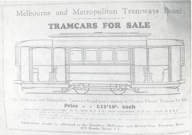
Document - Photocopy, Melbourne & Metropolitan Tramways Board (MMTB), "Bikes and public transport", c1930 original
Photocopy on A4 paper of an advertisement for the sale of single truck or four wheel MMTB tramcars for 12 pounds and 10 shilling each. Gives dimensions, gives conditions of sale (hard to read) and what they could be used for. Requires applications to be sent to the Secretary at 673 Bourke St Melbourne. Has an elevation drawing of a single trucker tram.trams, tramways, tram bodies, sale of trams, mmtb -
 Bendigo Historical Society Inc.
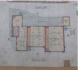
Document - MARKS COLLECTION: SIDE ELEVATION AND GROUND PLAN OF STAIRWAY
Plan drawn on waxed paper. On top 'Side elevation' written in black ink, shows bottom treads of staircase, ornate bottom post of balustrade. On bottom of plan 'Ground Plan' written in black pen, 'Scale 1 Inch to a Foot' Plan contained in Fortuna Villa, George Lansell documents, although Fortuna Villa not written on plan.bendigo, house, fortuna villa -
 Greensborough Historical Society
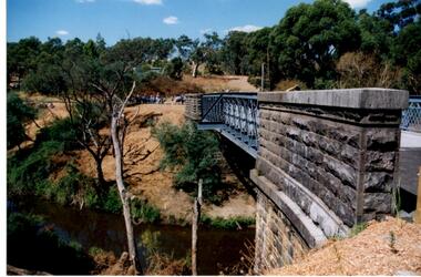
Photograph - Digital Image, Anne Paul, Opening of restored Old Lower Plenty Bridge 2001 - side view of bridge, 14/03/2001
The opening of the restored Old Lower Plenty Bridge, opened on 14/03/2001 by the Minister for Environment and Conservation Sherryl Garbutt MLA and Mayor of Banyule Cr Dale Peters. The project was jointly funded by Banyule Council and Parks Victoria. The restored bridge is the oldest remaining bridge in the former Shire of Eltham and forms part of the Plenty River Trail. This photograph shows the bridge from the side elevation, showing the bluestone and iron construction.Digital copy of colour photographlower plenty, lower plenty bridge, sherryl garbutt, dale peters, banyule council, parks victoria -
 Melbourne Tram Museum
Document - Comeng - All Electric Trams - Tender document, Commonwealth Engineering - Comeng, 1972
Folder prepared by Commonwealth Engineering "Comeng" to document their tender offer for the future Z class trams. Includes drawings SCH9273 and 9274 giving an elevation and plan of their proposal, a coloured illustration which is based on PCC tram 1041, notes on the specification dated 11/11/1972, Duwag documentation and photographs, interiors, alternatives and suppliers. Does not include a formal tendered price. See item 7200 for the final contract document.Demonstrates the Commonwealth Engineering 1972 proposal for the contract for the Z class tram.Plastic folder with three interscrews containing the contract tender documentation for the future Z class tram. Includes a copy of the Tender Schedule for "100 All-Electric trams" in a front cover pocket and many loose items in a rear pocked, includes drawings, photographs and documentation. Has "Comeng" in gold block on the front. Folder by Arnold's plastics of Sydney.tramways, mmtb, z class, tenders, new trams, comeng, commonwealth engineering, contracts -
 Federation University Historical Collection
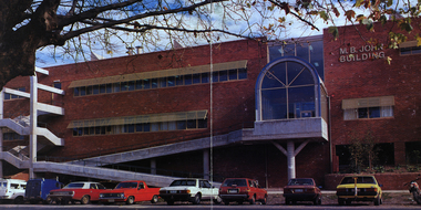
Image - Colour, Ballarat School of Mines M.B. John Building, Albert Street, Ballarat, 1987, 1987
The M.B. John Trade–Art building (Albert Street front) of SMB was officially opened by the Hon. John Cain, Premier of Victoria, in the presence of Morgan B. John. Programs include 3 Dimensional Art, Painting & Decorating, and Engineering Trades. (SMB Institutional Plan 1989) The M.B. John Building (Building K), a three storey, face red brick, restrained Late Twentieth Century International styled building with an elongated, cuboid form (defined by the parapeted facades) that is offset by projecting exposed concrete framed, round‐arched entrance and stair wells on the east (Albert Street) elevation (the centrally located entrance breaking the brick façade with glazing). The facades are also characterised by banks of aluminium framed, horizontal ribbon windows, which wrap around the building corners. Metal shades project beyond the windows, while post‐supported bullnosed verandahs and hoods and projecting concrete stairs are other features. On the west elevation, the cuboid façade is punctuated by projecting curved concrete and glazed, elongated bays at first floor level. (David Rowe/Wendy Jacobs)Image of a multi-storey brick building on the Ballarat School of Mines campus. The building is known as the M.B. John Building.ballarat school of mines, m.b. john building, morgan b. john, albert street, m.b. john -
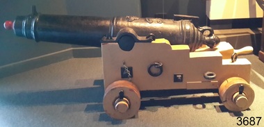 Flagstaff Hill Maritime Museum and Village
Weapon - Carronade, 1840
The carronade was designed as a short-range naval weapon with a low muzzle velocity for merchant ships, but it also found a niche role on warships. It was produced by the Carron Iron Works and was at first sold as a complete system with the gun, mounting, and shot altogether. Carronades initially became popular on British merchant ships during the American Revolutionary War. A lightweight gun that needed only a small gun crew and was devastating at short range was well suited to defending merchant ships against French and American privateers. The invention of the cannon is variously attributed to Lieutenant General Robert Melville in 1759, or to Charles Gascoigne, manager of the Carron Company from 1769 to 1779. In its early years, the weapon was sometimes called a "mellvinade" or a "gasconade". The carronade can be seen as the culmination of a development of naval guns reducing the barrel length and thereby the gunpowder charge. The Carron Company was already selling a "new light-constructed" gun, two-thirds of the weight of the standard naval gun and charged with one-sixth of the weight of the ball in powder before it introduced the carronade, which further halved the gunpowder charge. The theory of its design was to use less powder and had other advantages that were advertised in the company's sales pamphlet of the time, state. The smaller gunpowder charge reduced the barrel heating in action, also reduced the recoil. The mounting, attached to the side of the ship on a pivot, took the recoil on a slider, without altering the alignment of the gun. The pamphlet advocated the use of woollen cartridges, which eliminated the need for wadding and worming, although they were more expensive. Carronades also simplified gunnery for comparatively untrained merchant seamen in both aiming and reloading that was part of the rationale for adopting the gun. Other advantages promoted by the company were. The replacement of trunnions by a bolt underneath, to connect the gun to the mounting, reduced the width of the carriage that enhanced the wide angle of fire. A merchant ship would almost always be running away from an enemy, so a wide-angle of fire was much more important than on a warship. A carronade weighed a quarter as much as a standard cannon and used a quarter to a third of the gunpowder charge. This reduced charge allowed Carronades to have a shorter length and much lighter weight than long guns. Increasing the size of the bore and ball reduces the required length of the barrel. The force acting on the ball is proportional to the square of the diameter, while the mass of the ball rises by the cube, so acceleration is slower; thus, the barrel can be shorter and therefore lighter. Long guns were also much heavier than Carronades because they were over-specified to be capable of being double-shotted, (to load cannons with twice the shot, for increased damage at the expense of range), whereas it was dangerous to do this in a carronade. A ship could carry more carronades, or carronades of a larger calibre, than long guns, and carronades could be mounted on the upper decks, where heavy long guns could cause the ship to be top-heavy and unstable. Carronades also required a smaller gun crew, which was very important for merchant ships, and they were faster to reload. The small bore carronade and carriage is part of a collection of nineteenth Century Flagstaff Hill Guns and Cannon, which is classified as being of significance and was made a few years after the beginning of Queen Victoria's reign in 1837 and fires a 6 lb pound cannon ball. This nineteenth century artillery piece is a rare and representative item of artillery of this era, used predominately on ships, both military and merchant. The artillery piece, individually and as part of the collection, is highly significant for its historical, scientific and aesthetic reasons at the state, national and world level. This carronade represents the methods of artillery technology, its advancement and its modifications to suit dangerous situations that sailors encountered from attacks from free booters (pirates, living from plunder) or others at the time. Carronade firing a 6 lb cast iron ball, with a smooth bore barrel 6.5 cm in dia the item is mounted on stepped wooden carriage with wooden wheels. Cannon barrel can have its elevation adjusted via a wooden wedge. Gun carriage has loops for locating and holding in position to a deck by ropes. Carriage is a replica made 1982Cast into the barrel is the royal emblem of Queen Victoria (VR "Victoria Regina") indicating the carronade was cast during Queen Victoria's reign / 1840 & 4-2-0 denoting the weight of the barrel. Right hand trunnion has a serial number “8708”. Also on top of the barrel is the British "Board of Ordinance" identifying mark a broad arrow indicating the carronade was in military use. flagstaff hill, warrnambool, shipwrecked coast, flagstaff hill maritime museum, maritime museum, shipwreck coast, flagstaff hill maritime village, great ocean road, colonial defences, victoria’s coastal defences, warrnambool fortification, warrnambool garrison battery, warrnambool volunteer corps, ordinance, armaments, garrison gun, smooth bore cannon, carronade, black powder, 12 pounder, 1840, artillery, lieutenant general robert melville, charles gascoigne, carron company, mellvinade, gasconade -
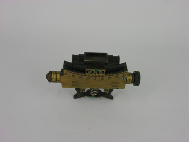 Frankston RSL Sub Branch
Clinometer
Sight clinometer MK IV used in conjunction with the QF 25 PDR field gun. This device was mounted on a fitting beside the gun barrel and used to accurately indicate the elevation of the gun barrel. The device is calibrated in degrees and minutes and is adjustable enabling the weapon to be accurately aimed. Standard equipment issued with the 25 PDR artillery piece. Refer to items 00111 and 00111.2