Showing 5313 items
matching flood-marker-orbost
-
 Kew Historical Society Inc
Photograph, Willsmere Bridge, 1934
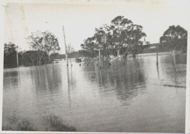
Several boathouses were built in Kew and Fairfield in the late 19th and early 20th centuries. They included Chipperfield’s ‘Moorings’ and floating pontoon. The substantial two-storey house was named the Moorings, and incorporated an upper storey residence. The Moorings was almost washed away in the 1916 floods, and in 1934 almost totally submerged when the Yarra River rose 26 feet in 14 hours. Following the 1934 flood, the house was restored. The floating pontoon, sometimes referred to as a ‘kiosk’ or ‘canteen’, was used to store canoes. Both were removed in 1972 for the construction of the Eastern Freeway.This work forms part of the collection assembled by the historian Dorothy Rogers, that was donated to the Kew Historical Society by her son John Rogers in 2015. The manuscripts, photographs, maps, and documents were sourced by her from both family and local collections or produced as references for her print publications. Many were directly used by Rogers in writing ‘Lovely Old Homes of Kew’ (1961) and 'A History of Kew' (1973), or the numerous articles on local history that she produced for suburban newspapers. Most of the photographs in the collection include detailed annotations in her hand. The Rogers Collection provides a comprehensive insight into the working habits of a historian in the 1960s and 1970s. Together it forms the largest privately-donated collection within the archives of the Kew Historical Society.A view of flooded areas in North Kew in the flood of 1934.Willsmere Bridge. Chipperfields. 1934 floodwillsmere, flood, yarra flood, chipperfields, chipperfields boathouse, north kew -
 Stawell Historical Society Inc
Photograph, Mr Thomas H L Saunders & Mr William Henry Saunders' Wooden Grave Marker at Stawell Cemetery
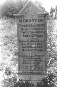
Wooden Grave Marker Stawell Cemetery – Thomas H L Saunders Died 1863 and William Henry Saunders Died 1874. Later destroyed by fire.stawell memorial -
 University of Melbourne, Burnley Campus Archives
Photograph - Black and white print, Flood in Orchard, 1934
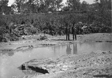
This photograph was sent to Burnley in an envelope printed, "On His Majesty's Service" Centenary Celebrations State of Victoria & City of Melbourne 1934-35 Department of Agriculture, Melbourne and handwritten on it "Flood in orchard 1/12/1934 Mr. Jessep." Note by T.H. Kneen 8 April 1992, "Alex Jessep (left) with Tom Trahair. Periodically Tom would take leave to go back to his home town Yackandandah to test a new theory to find the lost gold seam at the Little Waterloo mine."Black and white photograph. George Russ and Frank Ellery examining the ground by the flooded river. Uprooted trees behind them.This photograph was sent to Burnley in an envelope printed, "On His Majesty's Service" Centenary Celebrations State of Victoria & City of Melbourne 1934-35 Department of Agriculture, Melbourne and handwritten on it "Flood in orchard 1/12/1934 Mr. Jessep."george russ, frank ellery, centenary celebrations, orchard, tom trahair, 1934 flood, alex jessep, uprooted trees -
 Orbost & District Historical Society
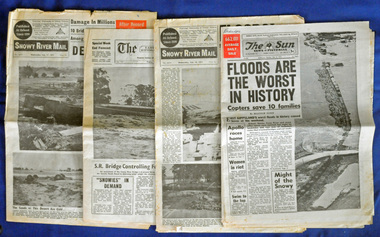
newspapers, February, March 1971
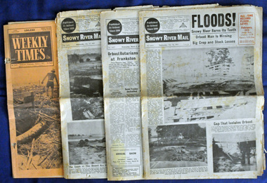
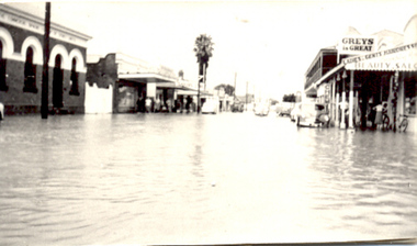
The 1971 flood was the the worst flood on record. At Jarrahmond it was at least 11 metres and up to one and a half kilometres wide on the flats causing enormous damage to the flood plain. Records say that "The brown floodwater stain in Bass Strait could be seen from passing airliners." Considerable damage was done to railway infrastructure, roads and farms. More information from the APRIL, 2008 newsletter by John Phillips. (see orbosthistory.com.au) These newspapers are contemporary records of a significant local event.Four newspapers relating to the floods in 1971. They contain news articles and photographs of the floods in Orbost in early 1971. 2556.1 is the Weekly Times dated 3.3.1971 and has an orange cover. 2556.2 is a Snowy River Mail dated 17.2.1971. 2556.3 is a Snowy River Mail dated 10.2.1971. 2556.4 is a Snowy River Mail dated 3.3.1971.floods-orbost-1971 snowy-river-mail weekly-times newspapers -
 Orbost & District Historical Society
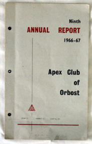
Booklet - ANNUAL REPORT, Ninth ANNUAL REPORT 1966-67 Apex Club of Orbost
This is a report of 1966-67 functioning of the Apex Club of Orbost. It has a membership list at the back of the booklet and also contains the names of office bearers etc. This Report was presented to the Handover Dinner 5 August 1967. President Don McKenzie; Vice Presidents Dennis Robinson, David Neal; Treasurer Graeme Duff; Secretary Keith MurrayEvidence of the functioning of the Apex Club of Orbost 1966-67 with names of members, activities, finances.A booklet of 13 pages with a grey coloured cover. On the cover are the words Ninth ANNUAL REPORT 1966-67 Apex Club of Orbost ZONE 12 DISTRICT 6 CLUB No. 251. Inside are copied pages of the Report including names of committee members, board members, and past presidents, also several b/w photos of activities, financial report, awards, and the President's Report 5 August 1967. as aboveapex club, orbost -
 Orbost & District Historical Society
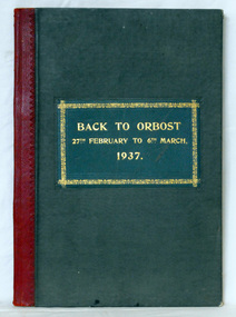
visitors' book, 1937
This book was used by Orbost Shire Council at the "Back to Orbost" celebrations in 1937 and again in 1963. The item was donated to Orbost & District Historical society from P.R.O.V. as a Place of Deposit (POD) item for safe keeping by a local history group or museum. The book was presented to the president, Jacob Perry, as a token of esteem and in appreciation of his interest and services to the movement. Jacob Perry was an Orbost farmer. Born 1874. Died 1950. He was a Boer War veteran , 4th Victorian Imperial Bushmen. He was a shire councillor and worker for school affairs. The book was used again on Friday, 8th March to Saturday, 16th March 1963.This item is a record of an early Orbost celebration and a useful reference tool.A green covered hard back visitors' book with a red spine and gold lettering on the front cover. It contains names and addresses and comments from those who attended the "Back to Orbost" celebrations in 1937 and in 1963. Entries have been hand-written in ink (1937) and biro (1963).On front in gold framed rectangle - "BACK TO ORBOST 27th FEBRUARY TO 6th MARCH 1937"visitors'-book back-to-orbost-celebrations perry-jacob -
 Tatura Irrigation & Wartime Camps Museum
Photograph, Flood Streetscape
Hogan Street 1955 floodtatura, buildings, historic -
 Melton City Libraries
Photograph, Flood at Toolern Creek, Unknown
Photos of a flood at Toolern Creeklandscapes of significance -
 University of Melbourne, Burnley Campus Archives
Album - Colour slides, Orbost Trip, 1969-1985
Box of slides labelled "Orbost Trip Oct. 69" with some additional slides dated 1980, 1982, 1985orbost, excursions, 1969 -
 Orbost & District Historical Society
Photograph - Flood, Snowy River, Orbost 1978
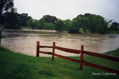
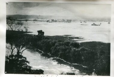
The Snowy River can flood over its floodplain at Orbost/Newmerella. There have been wet periods when floods were frequent and covered the floodplain, sometimes causing great disruption to crops and farming, and also to transport. The 1970s was a wet decade with many floods, the largest one in 1971. This photograph was taken in 1978. Evidence of flood on the Snowy River in 1978. A b/w photograph of a flood scene with trees and the river in the front, a river bank, and a vast area of water in the background. This photograph has been pasted onto a rough cardboard backing. Written below the photograph: Orbost 1978floods, snowy river, orbost -
 Orbost & District Historical Society
ledgers, Prescription Book, 1953 - 1984
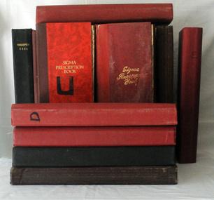
The chemist made an entry for each prescription for medicine that was given to a customer, and the date presribed. This entry was a handy reference for repeat prescriptions. Chemists who worked in Orbost included Henry Cottman; James Alfred Dubois Williams; Harry Arthur Murray; Miss P.E .Mason (Phyllis Estelle?); Miss Sybil Monica Buzza; Thomas James Frayer; Australia Shaw; James David Torley; John William Zimmer; Dalkeith William Steele; William Thomas Hollingsworth; E.E. Cohen; R.S. Anderson; Frances John Perry Faith Everard Pardew and Charles Anthony Wurf.These books have a clear association with Orbost. They provide a record of the ailments treated by the chemists over its long history, and the types of remedies used to treat them. They show the evolution of therapeutics and the development of diverse treatments The books are interesting in giving the names of the people who came to the shop and for the prevalence of diseases that were being treated. Sixteen ledgers to record prescriptions. Information details of patients' names, medications and prescriptions are hand-written. Details of individual ledgers are in catalogue folder.orbost-pharmacies medicine drugs prescription -records -
 Lakes Entrance Historical Society
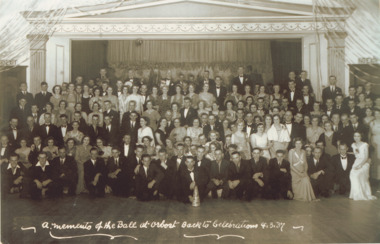
Photograph - Back to Orbost Ball, Celebrations 4.3.37, 4/03/1937 12:00:00 AM
Black and white photograph of crowd who attended the Back to Orbost Ball A Memento of the Ball at Orbost Back to Celebrations 4.3.37celebration, balls, events -
Clunes Museum
Ephemera - DVD, CLUNES FLOOD 2010, 2010
CD WITH PHOTOGRAPHS OF THE 2010 FLOODS IN CLUNESclunes floods 2010, floods 04/09/2010 -
 Tarnagulla History Archive
Photograph: Debris after flood, Newbridge, Debris after flood, Newbridge, 1909 (original image)
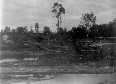
On 20th August, 1909 the Laanecoorie Weir broke away and released 18.3 million cubic metres of water through the opening and causing severe damage to all towns downstream. At Newbridge, Petersen's bakery collapsed and Simpson's Store and Hotel flooded to the roof. The billiard table was later found in a tree five miles down the Loddon near Learmonth. Murray Comrie Collection. Monochrome photograph, image depicting debris in the area near Loddon River at Newbridge after major flood in 1909. This is a very dark copy of an older original. Copy probably made by Murray Comrie in the 1960s.newbridge, loddon river, flood -
 Orbost & District Historical Society
newspapers, February 1971
The 1971 floods at Orbost were the worst on record. At Jarrahmond the river rose to a height of 11 metres and on the flats spread to one and a half kilometres wide. Considerable damage was done to railway infrastructure, roads and farms. More information from the APRIL, 2008 newsletter by John Phillips. (see orbosthistory.com.au)These newspapers are contemporary records of a significant local event.Four newspapers and a set of clippings from various papers. They contain information and photographs pertaining to the 1971 floods in Orbost. 2557.1 is a Sun News Pictorial dated 8.2.1971. 2557.2 is a Snowy River Mail dated 10.2.1971. 2557.3 is an east Gippsland News dated 12.2.1971. 2557.4 is a Snowy River mail dated 12.2.1971 and 2557.5 is a collection of various clippings.floods-orbost-1971 newspaper snowy-river-mail sun-news-pictorial -
 Melbourne Tram Museum
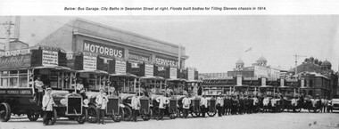
Photograph - Illustration, James Flood Charity Trust, c1914
Illustration from a photograph of 10 Tilling Stevens double deck buses operated by the Motorbus Services Limited. Have various destination of St Kilda Beach via Swanston St, St Kilda Rd Fitzroy St Esplanade. On the side of the bus is an advertisement for "Abbotsford Ale". From the James Flood Book as it notes that James Flood built 10 bodies during 1914 for the company. Photographed in Swanston St with the City Baths in the background.trams, tramways, melbourne, swanston st, buses, tilling stevens, private bus companies -
 Orbost & District Historical Society
charge book, 11.6.1885 - 30.1. 1944
The Sergeant, senior Constable, or Constable on duty at Orbost Watchhouse, received all charges against prisoners brought in by different constables, ascertained their nature and if satisfied it was a proper charge was obliged to record the name of each prisoner and the particulars of the offence. This information was recorded in a charge book. Recorded also were details pertaining to the charge itself included: the charge number; the date and hour of both the apprehension and the recording of the charge in the Charge book; personal details of the person being charged including name, address, date and place of birth, a short summary of the nature of the offence and any other relevant details which followed the charges. In general entries became less detailed over time but the format of the entries and the type of information collected remained similar.This book is associated with Orbost and provides insights into the nature of crime as well as the experiences of police and victims in Orbost.A large, heavy register with hand-written entries. Pages are ruled with columns and printed headings. It also contains an indexed list of names and dates in a separate section at the back.charge-booh-orbost-police-station crimes law -
 Tarnagulla History Archive
Photographs: Loddon River, Newbridge after flood, Loddon River, Newbridge after flood, 1909 (original image)
On 20th August,1909 the Laanecoorie Weir broke away and released 18.3 million cubic metres of water through the opening and causing severe damage to all towns downstream. At Newbridge, Petersen's bakery collapsed and Simpson's Store and Hotel flooded to the roof. The billiard table was later found in a tree five miles down the Loddon near Learmonth. Murray Comrie Collection. Two copies of a monochrome photograph, image depicts the area near Loddon River at Newbridge after major flood in 1909. This is a very grainy and dark copy of an older original. Copy probably made by Murray Comrie in the 1960s.newbridge, loddon river, flood, bridge -
 Ballarat Heritage Services
Photograph - Digital photographs, L.J. Gervasoni, Hopkins River Mouth in flood, c2010 - 2017
The flooded Hopkins River flows into the sea at Warrnambool.hopkins river, mouth, point ritchie, bluehole, warrnambool, coast, coastal, beach, seascape, flood -
 Orbost & District Historical Society
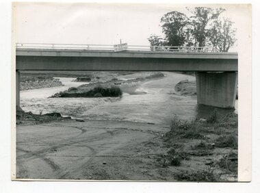
black and white photographs, October 22 1976
The road to Marlo was cut by flood waters from the Snowy River in two places. The road was closed when water flowed over Gilbert's Gulch (3243.1) The Snowy River broke its banks and flooded surrounding Orbost, Marlo, Lochend and Jarrahmond were isolated. The river bank at the bridge site was broken and filled with earth and rock fill. (3243.2) The new Snowy River Bridge was nearing completion when the river rose 7.2 metres causing erosion on the eastern bank. (3243.7) Contractors involved in the construction of the Princes Freeway and bridge were delayed by the flood waters. (3243.8) The 1976 flood at Orbost was a significant event which delayed the construction of the current Snowy River Road Bridge.These photographs record that event.Nine black / white photographs of flood waters across roads. orbost-flood-1976 snowy-river-bridge marlo-road-flood-1976 gilbert;s-gulch-flood -
 Orbost & District Historical Society
book, C 1930's
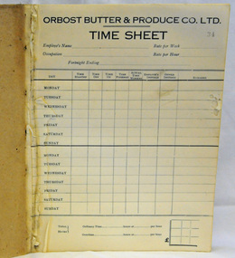
The Orbost Butter and Produce Co Ltd was registered on June 1st 1893. The site of the factory was purchased at a cost of five pounds from Mr James Cameron. (See In Times Gone By - Deborah Hall) The Orbost Butter and Produce Co. Ltd was registered on June 1st 1893 and was an important source of income to the Orbost district.A time sheet book. Some of the front pages have been torn off.The back page, p 100, has been filled in. Each page is printed with "ORBOST BUTTER & PRODUCE CO LTD." at the top with details of the employee, pay rates and hours worked to be hand-written.orbost-butter--produce-company -
 Orbost & District Historical Society
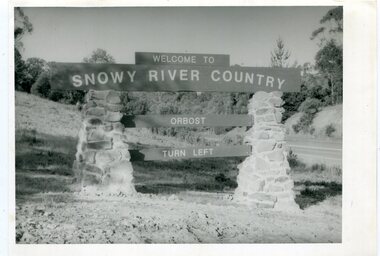
black and white photographs, second half 20th century
These photographs are pictorial records of the signs at the Orbost town entry points.Three black / white photographs. 3277.1 is a sign on stone pillars at the top of a hill - "WELCOME TO SNOWY RIVER COUNTRY ORBOST TURN LEFT". 3277.2 shows a road leading into a town. There is a sign on the left - "ORBOST" and a service station on the right. 3277.3 shows a row of newly planted trees between a road and a school.3277.1 on back - "WELCOME TO SNOWY RIVER COUNTRY - ORBOST sign - Princes Highway - Newmerella" 3277.2 on back - "East Gippsland Shire Sign on eastern approach to ORBOST., in Salisbury Street, near Orbost Secondary College" 3277.3 on back - "Tree planting in Salisbury St, Orbost in front of Orbost High School looking west towards Orbost township"photographs-orbost orbost-township-entry salisbury-street-trees town-entry road-signs-orbost -
 Orbost & District Historical Society
black and white photograph, January 1934
Orbost has been subject to major floods throughout its history, such as those which left the town isolated in 1934, 1952, 1971 and 1978. It is recorded that the Snowy River broke its banks and flooded the flats 104 times between 1884 and 1978. Extensive flooding in Eastern Victoria during June 1978, caused widespread damage to roads, road closures and hazards to traffic, particularly over the Queen's Birthday holiday weekend.This is a pictorial record of a significant event in Orbost's history.A very faded black / white photograph of flood water under the railway viaduct at watt's Gulch.orbost-flood-1934 railway-viaduct-orbost -
 Ballarat Tramway Museum
Postcard - Set of 6 and background card, Ken Flood, "Launceston Municipal Tramways"
The Postcards show trams of Launceston which operated from 1911 to 1952, published by International Railway Postcards of Launceston. The background card gives a short history of Launceston trams and the reproduction of two tickets. 1 - Postcard 1 - No. 11 leads a line up of cars in Elphin Road - Ken Flood 6-3-1948 2 - No 27, Mumford St loop - Ken Flood - 9-10-1948 3 - No. 24 Wellington St, photo Ken Flood, 26-2-1949 4 - No. 9 turns from George St into Cameron St - 25-9-1948 - Photo Ken Flood 5 - No. 26 - Talbot Road terminus - 1-11-1948 - Ken Flood 6 - No. 9 Elphin Road, 13-10-1948 - Ken Flood Yields information about Launceston trams, the Museum having No 14 on display, No. 14 from 2022.Set of 6 black and white postcards and a story card. Each have a caption on the rear and a place for a stamp and address.launceston, tramways, tramcars -
 Tarnagulla History Archive
Photographs: Loddon River, Newbridge after flood, Loddon River, Newbridge after flood, 1909 (original image)
On 20th August,1909 the Laanecoorie Weir broke away and released 18.3 million cubic metres of water through the opening and causing severe damage to all towns downstream. At Newbridge, Petersen's bakery collapsed and Simpson's Store and Hotel flooded to the roof. The billiard table was later found in a tree five miles down the Loddon near Learmonth. Murray Comrie Collection. Two copies of a monochrome photograph, image part of damaged bridge in the area near Loddon River at Newbridge after major flood in 1909. This is a very grainy and dark copy of an older original. Copy probably made by Murray Comrie in the 1960s.newbridge, loddon river, flood, bridge -
 Orbost & District Historical Society
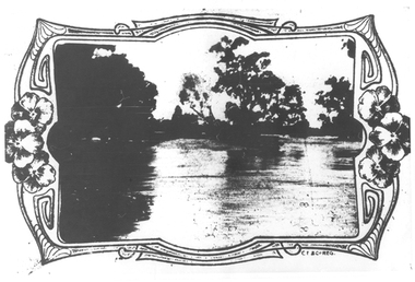
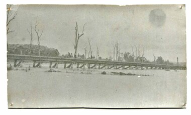
postcard, C1920-1940
This photograph shows the second major bridge across the Snowy River at Orbost. The current Snowy River bridge is the fourth to provide a crossing to the township of Orbost. The first, in 1891, lasted just two years before it succumbed to flood waters. The bridge in this photograph was built in the 1920s as a road and rail bridge, and was again partly washed away by flood waters in 1934. After the end of the first World War the Victorian Railways considered an extension of the railhead across the river at Orbost, and in 1922 a new timber and steel girder structure, a joint Country Roads Board — Victorian Railways venture, was built and completed at a cost of £41,000 (the steel girders came from the Flinders Street viaduct reconstruction). Subsequently it was decided not to take the railway across the river, and the bridge was only used by road traffic. It was severely battered by floods during its life. and after the 1971 floods was eventually replaced by the current bridge in 1975. (info from Newletter 54N by John Phillips) This item is an early pictorial record of the previous Snowy River bridge at Orbost.A postcard with a black / white photograph of a bridge - timber and steel girder structure - across the Snowy River at Orbost, Reflections of the bridge are seen in the water.snowy-river-bridge-orbost -
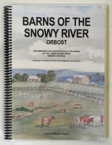 Orbost & District Historical Society
book, Barns of the Snowy River Orbost, 2006
This is a book written by a local historian containing historical information pertaining to Orbost and the surrounding district. A spiral bound book of 191pp. On the front and back covers are coloured print of the Morgan Barn c 1900, an original watercolour, artist unknown. The book documents the distinctive slatted barns of the lower Snowy River, Orbost, Victoria. The book was published by the Orbost Historical Society and was written by May Leatch and Ngaere Donald. It contains B/w photographs, drawings and stories of the barns and their histories.history-agriculture-orbost barns-slatted -
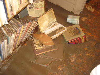 Ballarat Heritage Services
Photograph - Colour, Bookcase, Flood Recovery, Carisbrook
Colour photograph of the muddy remains after the Carisbrook Flood.carisbrook, floods -
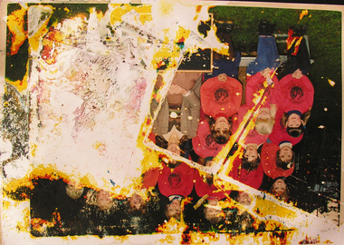 Ballarat Heritage Services
Photograph - Colour, Flood recovery, Carisbrook
Colour photograph damaged during floods at Carsibrook, Victoria. carisbrook flood, disaster recovery