Showing 2496 items
matching gardens and parks
-
 Greensborough Historical Society
Photographs, Photographs by Maria Barbaro, 2009_
A collection of over 170 photographs taken by artist Maria Barbaro as studies for her paintings. Taken in the Greensborough area, photos cover a wide range of natural and built landscapes, including the Plenty River; parks and gardens; the Greensborough Hotel; Ashmead; Greensborough railway station.A variety of photographs of the Greensborough area in the early 21st Century.Folder containing approx 150 colour photographs of Greensborough area. Each photograph 10x15cmmaria barbaro, greensborough -
 Ballarat Tramway Museum
Photograph - Tram 31 Gardens Loop, 1/1966
Photograph - Black and white of Ballarat tram No. 31 parked at Gardens Loop in Wendouree Parade. In the background are the large trees that were a feature of this location and on the pole behind the tram, the timetable boards. Not known who took the photo on a very quiet day during Jan. 1966.Yields information about the appearance of tram No. 31 during Jan 1966 and Gardens Loop.Black and white photograph on Ilford paper.In ink on rear "Gardens 1/66"tramways, wendouree parade, gardens loop, tramcars, tram 31 -
 Bendigo Historical Society Inc.
Photograph - VIEWS OF BENDIGO
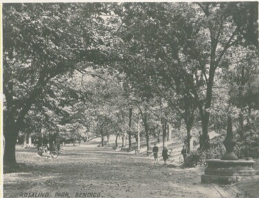
Photographs - 8 of (small) black & white. Photo's of Pall Mall (no.22), Civic Buildings (no.1), The Baths Upper Reserve (no.13), Alexandra Fountain (no.6), Conservatory Gardens (no.29), City Hall (no.8), Central Deborah Mine (no.19), Rosalind Park (no.5). Handed in by Barry & Vicki Mulvena of 48 Lord St.,m Roseville, NSW 2069.Valentine's Snapshots.place, bendigo, picturesque views of bendigo., views of bendigo. -
 Bendigo Historical Society Inc.
Photograph - BENDIGO - PANORAMA FROM FIRE TOWER
Photograph - sepia. Photograph panorama from Fire Tower, Bendigo.. In the distance shops that I can read 'Mobiloils', 'Cockings', 'Cocks Motor Garage', back view of the Conservatory building and gardens. The Rose Series P.3231. It is written on back but unable to read much, its from Monica. Trees etc along the bottom front are part the rosalind park.Rose Seriesplace, aerial view of bendigo, fire tower., bendigo. panorama from fire tower. -
 Bendigo Historical Society Inc.
Slide - Images by Arthur Pulfer, 1957-58
Many images from by Arthur Pulfer copied to slides. Twenty Slides of Bendigo images: Les Penna's Plane February 1970 'Music to the People' Rosalind Park Bendigo 1956 Bendigo Art Gallery View Street 1957 View from the lookout in Rosalind Park Bendigo 1957 Charing Cross Bendigo March 1972 Stramit Board Works - Allingham Street Golden Square Bendigo 1957 Penna's starting gates Bendigo 1958 Bendigo Conservatory Gardens Autumn Flowers Easter 1957 Youth Sunday Bull Street Bendigo 1957history, bendigo, james lerk collection, bendigo conservatory, brass bands bendigo, rosalind park bendigo, bendigo art gallery, stramit board works bendigo, les penna's plane, penna starting gates, conservatory gardens bendigo -
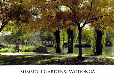 Wodonga & District Historical Society Inc
Photograph - Eric Sumsion Gardens
... Eric Sumsion Gardens ...Mr Eric Sumsion was the gardening curator for Wodonga Shire in 1956. He had previously operated a bootmaker’s shop in High Street, Wodonga for many years. Eric saw the potential of the area in Wodonga now known as Belvoir Park and asked permission to work on part of the area. He eventually purchased a house adjoining the area giving him more time and easy access to work on it. The Lagoon, Lake Huon, Belvoir Lagoon, Belvoir Park and Sumsion Gardens are all names used over time for what is today one of Wodonga’s favourite recreation and picnic spots. In the 1800s river boats could enter Lake Huon from Wodonga Creek. There was a jetty south of where the water fountain is today. In later years, this jetty was used by the Clay Bird Shooting Club. From the early 1900s football and cricket were played there, and some mining leases were also allowed. At one time there were open gravel pits between House Creek and the main lagoon, and these were subsequently filled with town garbage collected by the Council. In the late 1940s, Wodonga Golf Club took over part of Belvoir Park for a 9-hole golf course with sand greens. The Golf Club House was built in 1946. The Club extended the course to 12-holes when the football ground moved to Martin Park and the course later extended to 18 holes. Under Eric Sumsion’s care the area became a magnificent area of parkland and curated gardens. After he had retired in 1961 his work was acknowledged by the Shire Engineer, Mr Bill Page, when the Sumsion Gardens were named in his honour. He was also responsible for the design and curating of many other gardens in Wodonga, including those at Sarah Coventry and Richardson Park. Eric Sumsion died in July 1988, aged 85.This item is significant because it acknowledges the dedication and commitment of Eric Sumsion to the Wodonga Community.A collection of photographic image and an advertisement related to the work of Eric Sumsion in Wodonga.eric sumsion, parks and gardens wodonga -
 Greensborough Historical Society
Newsletter, Greenhills and North Greensborough Progress Association, Community News: official journal of the Greenhills and North Greensborough Progress Association. 27th July, 1972. Edition No. 5/72, 27/07/1972
This edition includes a report on the Progress Association's July 1972 meeting, Year of the Book, Spring planting time, School and kinder news, Letter to the editor, Megalopolis or the bush, Parks, gardens and reserves, Eltham Film Society. Supplement to July 1972 "Community News" Open forum.Newsletter, 16 p., illus. greenhills and north greensborough progress association, greenhills -
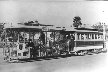 Melbourne Tram Museum
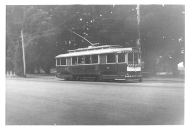
Photograph - Cable tram 306 - Prk St Sth Melb, c1930
Photo of a cable tram set, trailer 306, in Park St South Melbourne with the St Vincent Gardens in the background. The photo is taken after the construction of the Collins St electric line in 1929 as the destination board notes the tram is connecting with Collins St electric trams. The gripman is waiting for the phtograph to be taken, with the Conductor on the platform of the trailer car. In the background are the Gardens and housing of this area. Photo c1930. The South Melbourne cable tram line closed for conversion in 1937.Yields information about the South Melbourne cable tram line and Park St.Black and white print with a plain backtrams, tramways, south melbourne, tram 306, cable trams, park st -
 Ballarat Tramway Museum
Photograph - Tram 40 Gardens Loop, 1/1966
Photograph - Black and white of Ballarat tram No. 40 parked at Gardens Loop in Wendouree Parade. In the background are the large trees that were a feature of this location. Not known who took the photo during Jan. 1966. Note the two numbers on the front of the tram, as result of the installation of the dash canopy lighting.Yields information about the appearance of tram No. 40 during Jan 1966 and Gardens Loop.Black and white photograph on Ilford paper.In ink on rear "Gardens 1/66"tramways, tram 40, wendouree parade, gardens loop, tramcars -
City of Kingston
Photograph - Black and white, 5 January 1984
Moorabbin, Cheltenham and Highett are suburbs in the City of Kingston with a diverse mix of development and zoning. The market gardens, farms and paddocks have gradually been sub-divided into housing and industrial estates and associated infrastructure such as schools and shopping facilities. The area includes many parks, reserves and golf courses.This aerial image covers a diverse section of the City of Kingston, taking in the suburbs of Cheltenham, Moorabbin, Beaumaris and Highett. By 1984, the market gardens of the district have been replaced by housing and factories. The Gas and Fuel state-of-the-art Scientific Services Department is visible on Nepean Highway Highett. The CSIRO Highett site can also be seen. Both sites have now been demolished and have undergone remediation. The Southland site is visible and yet to be redeveloped by Westfield. This image portrays the diversity of development in the City of Kingston with a mixture of green spaces, housing and commercial and industrial features.Aerial photograph of Cheltenham, Beaumaris, Moorabbin and Highett within the City of Kingston. The area depicted in the 1984 aerial view includes Eden Street and Edward Street, Cheltenham (top left), Weatherall Road and Reserve Road, Cheltenham/Beaumaris (top right), Turner Road and Chesterville Road, Moorabbin (bottom left), Nepean Highway (left section), Graham Road and Middleton Street, Highett (bottom right). A large section of this image includes Cheltenham Park and Victoria Golf Club.White text: 3831-219 Lens information [indecipherable] RINGWOOD M/S 7922-3 RUN 15 Clockface image 5,300' ASL VIC DLS© 5-1-84cheltenham, highett, industrialisation, urbanisation, moorabbin, beaumaris -
 Federation University Historical Collection
Document - Documents, Golden Point - Mount Pleasant Progress Association Establishment
The Golden Point - Mt Pleasant Progress Association was established on Wednesday 6 April 1983. Membership was open to any person or organisation in the area generally bounded by Bridge mall and Skipton Street, Elsworth Street and main Road. annual family or organisation membership was $2.00. Mara Gluyas served as secretary of the Golden Point - Mt Pleasant Progress Association from 1983 to 1994. Ian McKinnon was the President from 1983 to 1992. Kerry Daniels was the President in 1994.A small white cardboard box with purple lid of A4 documents relating to the establishment of the Golden Point - Mt Pleasant Progress Association. The documents include the original constitution and minutes. Topics include: Pearce's Park; removal of elms, names and addresses of members, Sovereign Hill realignment; Sovereign Hill Lookout; membership form; Golden Point Historic Mines Direction Indicator; Ballarat Observatory; Nerrina Tip; Yarrowee Creek; Mine Capping (Sovereign Mine); tree planting (Sovereign Hill Lookout); Magpie Street Park; Hill Street; Yarrowee Flora Park; Barkly Street; South Street Bluestone Gutter; Ballarat Goldfields; Eastern baths site; Grant Street; Flooding; Aboriginal Advancement League; Sunnyside Woollen Mill; Chinese Garden; Golden Point Primary School closure; Ballarat West Goldfields; Sovereign Hill Land Title and Management Revision; Wainwright; Street; Llanberris; Yuille's Station Parkgolden point, mount pleasant, mt pleasant, ian mckinnno, mara gluyas, peter hiscock, frank williams, geoff howard, leigh gillett, sovereign hill, kerry daniels, norm strange; graeme kent; george netherway; keith rash; ian mckinnon, albert graham, bryan crebbin, jim humphreys. wid radbourn, heath martin, janet dore, alex mills park -
Glen Eira Historical Society
Article - Princes Park
This file contains four items. Princes Park information kit (misspelled princess park) compilation (clipped together) of photocopied material about aspects of the park, beginning with Princes Park North East Ground, official report for Glen Eira Council on condition of the park and recommendations for improvements, with blueprints and maps of proposed development. No date but most recent dated page (two letters from Douglas R Aylen, Chief Executive Officer, City of Caulfield, to residents about Princes Park playground is dated 20/05/1991. Includes photocopies of official materials on the purchase of land for the Park beginning in 1920. About sixty pages in all of which several relate to Caulfield Football Club and its campaign for a new pavilion 1967-70. Community News featuring Caulfields Parks and Gardens cutting from Caulfield Contact, 12/1991, on improvements to the park. Photocopy of letter from Rohan Storey Campaigns Coordinator, National Trust of Australia, Victoria to Manager, Planning Section, Glen Eira Council, dated 13/09/2002, headed National Trust Classification of Tree at Princes Park, South Caulfield Quercus suber (cork oak) at Regional level. Includes attached assessment form. Two black and white photocopies of photographs of Princes Park undated from Glen Eira Library Princes Park file, handwritten verso.princes park, parks and resources, glen eira city council, wilson k.d, harris mr, bricker d.c, caulfield football club, victorian football association, princes park trust, evans tim, ladson w.t, dixon r.c, caulfield church of christ, lewis mrs. i.e, caulfield south bowling club, hawkins a.w, briggs j.a, mcdonald s.l, renouf l.s, patience geoff, little ajax football club, gardenvale football club, south east suburban football club, southern metropolitan police football club, caulfield city soccer club, christian brother old boys, caulfield bears cricket club, national trust of australia (victoria), cork oak, tree, storey rohan -
 University of Melbourne, Burnley Campus Archives
Album - Black and white and colour prints, colour 35mm slides, Geoff Olive, Geoff Olive Collection, 1979-2000
Collection of photographs and slides taken by Geoff Olive (Horticultural Instructor). (1) "Burnley 1979 Flash flood outside engineering." (2, 3) Administration Building, different years. (4) "Trish Mooney Gardener 1998." (5) 15-7-00 Ellis Stones Garden Friends Working Bee Tim and Chris." (6, 7) "Photos taken by John Dwyer (N.C.H.H.) following a tour of the native garden area given by Chris. 3.11.99." (8) Garden Week 1989? Phil Tulk Andrew Smith." Slides (9) "Rose Bed." (10) "Choisya ternata." entrance to what became the Rose Garden from Oak Lawn. (11) Aug 1981 view of Luffmann Ponds from Administration Building. (12) Nov 1982 "Herbaceous Border & Annual Display BHC" view of Bergenia Walk towards Administration Building. (13) May 1986 view of Administration Building from Luffmann Ponds. (14) August 1990 "Paula Cave/Andrew Smith" rejuvenating Luffmann Ponds. (15) April "Andrew Smith" mulching around Cork Oak when Staff Car Park removed from Bull Paddock. (16) April 1990 compacted lawn after last Garden Week at Burnley. (17) August 1990 Garden view. (18) August 1990 view of Luffmann Ponds from Administration Building roof. (19, 20) August 1990 View of Kath Deery Native Garden from Administration Building roof. geoff olive, horticultural instructor, burnley, floods, administration building, trish mooney, gardener, 1998, ellis stones garden, working bee, john dwyer, phil tulk, andrew smith, kath deery native garden, rose garden, herbaceous border, paula cave, luffmann ponds, bull paddock, garden week -
 Port Fairy Historical Society Museum and Archives
Photograph
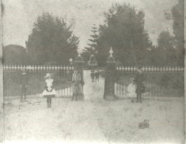
... gardens ...Gardens Port Fairy - showing family group at the entrance to the botanical gardens. The Port Fairy Botanical Gardens were formed in 1856 making it one of the earliest gardens in Victoria. The first curator was James Prior, he was paid fifty-two pounds per annum. He was an outstanding curator having been apprenticed to the trade in England at the age of 12, his brother Edward in later years was the Curator of the Koroit Gardens. Prior retired in 1903. During the years of his curatorship Port Fairy was said to have the best gardens outside the city of Melbourne, he was constantly in touch with Baron Von Mueller and later Guilfoyle of the Royal Botanical Gardens of Melbourne. In the early years plants from all over the world were planted here with varying rates of success many of them sent by Baron Von Mueller. In the 1930’ and 40’s the gardens were still very beautiful, and the curator was Roy Manuell. The beautiful iron gates at the entrance were destroyed in the 1946 floods and were replaced in 1989 using some of the material from the original gates. From the 1950’s on the gardens went into a state of decline, much being taken up by the caravan park until in 1986, after a public meeting ‘Friends of the Gardens’ was founded when the entrance section was restored. Photographgardens, family, group, people, gates, entrance, botanical -
 Port Fairy Historical Society Museum and Archives
Photograph
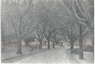
... gardens ...Gardens in winter. The Port Fairy Botanical Gardens were formed in 1856 making it one of the earliest gardens in Victoria. The first curator was James Prior, he was paid fifty-two pounds per annum. He was an outstanding curator having been apprenticed to the trade in England at the age of 12, his brother Edward in later years was the Curator of the Koroit Gardens. Prior retired in 1903. During the years of his curatorship Port Fairy was said to have the best gardens outside the city of Melbourne, he was constantly in touch with Baron Von Mueller and later Guilfoyle of the Royal Botanical Gardens of Melbourne. In the early years plants from all over the world were planted here with varying rates of success many of them sent by Baron Von Mueller. In the 1930’ and 40’s the gardens were still very beautiful, and the curator was Roy Manuell. The beautiful iron gates at the entrance were destroyed in the 1946 floods and were replaced in 1989 using some of the material from the original gates. From the 1950’s on the gardens went into a state of decline, much being taken up by the caravan park until in 1986, after a public meeting ‘Friends of the Gardens’ was founded when the entrance section was restored. Bare trees In theBotanical Gardensgardens, botanical, griffith street, winter, autumn -
City of Kingston
Photograph - Black and white, 17 January 1951
Moorabbin, Cheltenham and Highett are suburbs in the City of Kingston with a diverse mix of development and zoning. This 1954 image shows the market gardens, farms and paddocks of the Moorabbin and Cheltenham area. which have gradually been sub-divided into The Highett Gas Works is visible and Cheltenham Park and Victoria Golf Club.The suburbs of Cheltenham and Moorabbin were originally developed with extensive market gardens. Over time the district has been transformed with the farms and paddocks replaced by housing, factories and shopping centres. The Highett Gas Works on the Nepean Highway was a significant feature of the landscape and has now been demolished. and the site has undergone remediation.Aerial photograph of Cheltenham, Moorabbin and Highett within the City of Kingston. The area depicted in this 1951 aerial view includes Wickham Road, Highett (bottom right), Keys Road, Moorabbin (bottom left), Centre Dandenong Road Cheltenham (top left), Park Road, Cheltenham (top right), Nepean Highway (left section), Graham Road and Middleton Street, Highett (bottom right). Cheltenham Park and Victoria Golf Club are visible. Nepean Highway and the Frankston railway line run centrally through the image.White type: 1416-37 538 RUN239 LENS 5312" MELBOURNE METROPOLITAN 12150 17-1-51 ↆ M539 Black pencil: N [arrow]cheltenham, highett, highett gas works, market gardens -
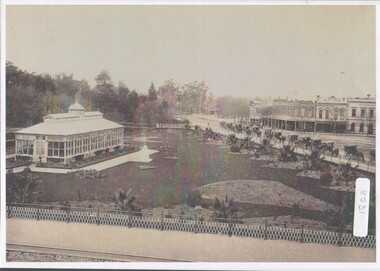 Bendigo Historical Society Inc.
Photograph - Bendigo Conservatory and gardens
Fifty nine acres of land was reserved for a park in1861, and the first gardener began setting out the gardens in 1870. The conservatory was built in 1897 and is the last building of its type in a public park.The conservatory was designed by Mr G. Minto, city surveyor at the time. The building is 72 feet long and 24 feet wide. The walls re twenty two feet high and are topped by a lantern roof, adding a further six feet. It was built at a cost of between 700 and 800 pounds.B&W photograph with view over the Bendigo Conservatory and gardens with a line of twelve horse drawn cabs on Bridge Streetconservatory gardens, bendigo -
 City of Moorabbin Historical Society (Operating the Box Cottage Museum)
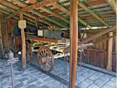
Functional object - Plateway horse-drawn wagon, c. 1883
... gardens ...This Plateway Wagon was built by Pengelly's Carriage Works, North Brighton 1883. The wagon was owned by the Corrigan family, market gardeners in Noble Park. It is an original, timber horse-drawn wagon that used the the Plateway or Wheelway from 1890. These heavily laden market gardener’s carts could travel relatively smoothly and safely, along the steel rails on the main roads of Moorabbin Parish to Melbourne and St Kilda markets to sell their produce, at a time when the road surfaces were rutted and hazardous.After the Henry Dendy Special Survey of the Parish of Moorabbin in 1841, land was sold to pioneer settlers who developed market gardens, vineyards and fruit gardens ( orchards ). These market gardeners took their produce in heavily laden horse-drawn Wagons along the steel Plateway to the markets in St Kilda and Melbourne. An original, timber horse-drawn wagon of a type that used the Plateway or Wheelway. The steel rails of the Plateway played such an important role from the 1890’s in the transportation of produce along the City of Moorabbin’s major roads, (including Centre Road, Bentleigh), to reach the markets in St Kilda and Melbourne. Heavily laden market gardener’s carts , drawn by a horse, could travel relatively smoothly and safely, along the steel rails to city markets, at a time when the road surfaces were rutted and hazardous. horse, melbourne, brighton, moorabbin, steel, henry, dendy, fruit, gardens, roads, plateway, wheelway, bentleigh, vineyards, orchards, draught, markets, st kilda, wagons -
 Bendigo Historical Society Inc.
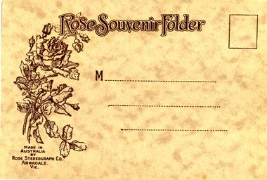
Photograph - BENDIGO PHOTO FOLDER, 1920's
Rose souvenir folder containing fourteen black & white photographs Of Bendigo buildings and scenes. Pall Mall & PostOffice, Upper Reserve showing Municapal Baths, Memorial Hall & Po, Mitchell Street, The Conservatory, Lake Weeroona showing Boat houses, Pall Mall, Soldiers Memorial, Queens Gardens, Shamrock Corner, Rosalind Park, The Fernery, Pall Mall , Alexandra Fountain.Rose Stereograph Co, Armadale Vicbendigo, buildings, heritage buildings -
 University of Melbourne, Burnley Campus Archives
Plan, Burnley Gardens. City of Richmond. Parish of Jika Jika - County of Bourke, 1927
... Burnley Gardens. City of Richmond. Parish of Jika Jika ...Part-coloured plan showing drainage, sewerage drains, taps and waterstops. Area bounded by Swan St. To N, Yarra River on E and Richmond Park on SW side. Contour lines of orchard depicted, laying pens and yards. Coloured area depicts pavilion with surrounding garden and paths layout pencilled in. Photo-Lithograph by Dept. of Lands & Survey, Melbourne by W. Butsonsewerage, drainage, lithograph, pavilion -
University of Melbourne, Burnley Campus Archives
Plan, The Museum of Modern Art at Heide, 1995
... gardens ...(1) Photocopy of Herb and Plant Location Map, Heide Kitchen Garden, plants numbered, no legend. (2) 1 tracing paper, 1 paper and 1 paper reduced size, Sketch Plan. Scale 1:1000. Drawn by JK 06.06.1995. (3) Photocopy of Heide Park and Art Gallery Grounds and Planting. Numbered Plant List, 1 Trees, 2 Shrubs.heide, museum of modern art, gardens -
 University of Melbourne, Burnley Campus Archives
Album - 35mm Colour slides, BHC Historical, 1950-1972
Miscellaneous slides labelled "BHC Historical". Some individually labelled. 1, 2 and 5. of a display "trees to serve the community". "VPRI" (Victorian Plant Research Institute). 10 and 11. of "Wilson's Prom" 1950's. 12. "Apiary" 13. "Students Planting Wattle" beside the Yarra Oct 72. 17. "Native Park Area" 1960's. 14. Garden view.burnley horticultural college, trees, community, vpri, victorian plant research institute, wilsons promontory, apiary, students, wattle, garden views, yarra boulevard -
 Eltham District Historical Society Inc
Album - Photograph, J.A. McDonald, Garden Hill, Kangaroo Ground, c. 1962
Garden Hill burnt following bush fires - most likely the 15-16 Jan 1962 fire A helicopter can be seen flying over the top of the hill Eltham Shire Council purchased this property in the early 1970s and it has now been incorpoarted within the Shire of Eltham Memorial ParkRecord of various Shire of Eltham infrastructure works undertaken during the period of 1952-1962 involving bridge and road reconstruction projects, sometimes with Eltham Shire Council Project Reference numbers quoted. It was during this period that a number of significant improvements were made to roads and new bridges constructed within the shire that remain in place as of present day (2022). In many situations, the photos provide a tangible visible record of infrastructure that existed throughout the early days of the Shire. The album was put together by or under the direction of the Shire Engineer, J.A. McDonald.1962, garden hill, kangaroo ground, shire of eltham memorial park, victorian bushfires - 1962 -
 Eltham District Historical Society Inc
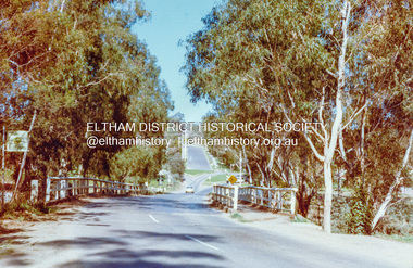
Photograph, Wattletree Road Bridge, Eltham, c. August 1977, 1977
Traffic island at intersection is lined with white-painted bluestone edging which originally was part of the Eltham lock-up situated at 728 Main Road. The bluestone has since been re-used (from late 1980s) at the rear of 728 Main Road to form the garden bed in car park. Colour photographeltham, infrastructure, main road, shire of eltham infrastructure, wattletree road bridge, bridge -
 Friends of Ballarat Botanical Gardens History Group
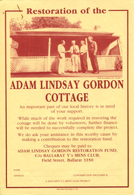
Work on paper - Adam Lindsay Gordon Cottage, Restoration, 1989, 1989
... Gardens...Craig's Hotel, Lydiard Street and Botanical Gardens ...The Ballarat Y's Mens Club Project had this leaflet printed calling for funds to restore the Adam Lindsay Gordon Cottage. The letter to Mr R.Whitehead, Director, Parks and Gardens from Dr.R.R. Schrieke, President of YMCA, 23/1/1989, confirms their interest in the active involvement in the restoration and management of the Cottage.The Adam Lindsay Cottage was seen as an important part of local history.1 sheet of yellow paper with printing and picture of Adam Lindsay Cottage and 1white sheet of paper with blue and red print in the heading. There is the red and blue international logo for the YMCA and the heading Y's Men"s Club of Ballarat. john garner, doctor, john garner collection, ballarat botanical gardens, adam lindsay gordon cottage, craft cottage, craig's hotel, australian poet, ballarat y's mens club project, restoration, ymca, doctor r.r. shrieke, mr r.whitehead, director of ballarat parks and gardens, gardens, ballarat -
 Southern Sherbrooke Historical Society Inc.
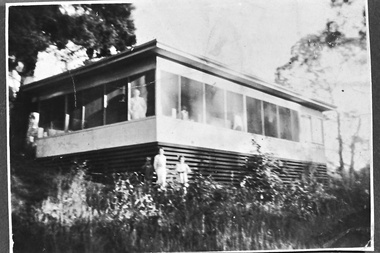
Photograph - Smith family holiday house on Park Drive, Belgrave, c.1940s
Black and white photo of the Smith family house on Park Drive just past Belgrave Lake Park. The House appears to have an enclosed verandah. A man, possibly Oscar Smith, is looking out of the window and a second person, possibly Pam Harris's sister, is also looking out. Below them, two young people, a boy and a smaller girl, are standing in the garden. This was possibly the caretaker's place. '1627' is stamped on the back of the photo. The photo probably dates to the 1940s and is part of a collection of family photos donated by Pam Harris, Shire of Sherbrooke President, 1982-1983 & 1987-1988. -
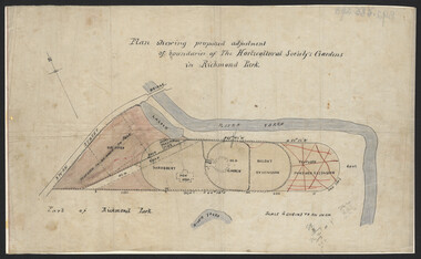 University of Melbourne, Burnley Campus Archives
Plan, John S. Jenkins, Plan showing proposed adjustment of boundaries of the Horticultural Society's Gardens in Richmond Park, c.1880-1884
... Horticultural Society's Gardens in Richmond Park...gardens ...Plan on linen fibre cloth. Shows layout of Burnley bound by Swan St., Yarra River and part of Richmond Park, coloured areas showing proposed area to be added to Park, the old road, shrubbery, new hall, old garden, recent extension and proposed further extension (crossed out in red ink). Scale 4 chains:1 inch. Probably drawn by John S. Jenkins, Town Surveyor, Richmond. Has been photographed so that additional copies can be made. On a CD plus 3 negatives. (Also copy glazed and framed for Centenary Exhibition.)john s. jenkins, gardens, richmond, hoticultural society of victoria -
 RSL Victoria - Anzac House Reference Library and Memorabilia Collection
Photograph, Macleod Repatriation Sanitorium, circa 1914
The former Mont Park/Bundoora Psychiatric and Repatriation Hospitals Complex consisted of seven hospitals on a site of 185 hectares. The site comprising the Mont Park and Strathallen estates was consolidated by the Victorian government by purchase and transfer from the Closer Settlement Board in 1909 . The Mont Park Hospital commenced in 1910 with the building of the Farm Workers Block . In 1912 the landscape gardener Hugh Linaker was employed to layout the grounds of Mont Park and other State mental hospitals. The other hospitals were gradually split off from the Mont Park administration to form separate entities included among these was the Macleod Repatriation Hospital (1915), An agreement was made with the Defence Department in 1914 for the latter to erect the Mont Park central block (the "Chronic Wards") for use as a Military Hospital, and for it later to revert to the State as portion of Mont Park Hospital. The buildings now known as the Chronic Wards were completed in this way in 1916 and used as the Australian General Hospital no. 16 for the duration of the war. One wing of this building was set aside for mental patients during this period. Silver gelatin photographww1, macleod repatriation sanitorium, mont park -
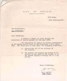 Bendigo Historical Society Inc.
Document - NORMAN OLIVER COLLECTION: ALLOCATION OF SPORTS GROUNDS FOR SCHOOLS 19 FEBRUARY 1964
The Norman Oliver collection. Norman Oliver was three times Mayor of Bendigo - 1950-51, 1964-65, 1970-71. Three typed pages - a covering letter from City Hall dated 19th February 1964, to the Head teacher regarding the allocation of sports grounds for 1964, a weekly timetable for the use of each ground by a particular school, and a list of special allocations. The grounds allocated are : Queen Elizabeth Oval, Showgrounds, Kennington, Golden Square, Ewing Park, Wilkie Park, Centenary Oval, Garden Gully, Garden Gully (new Basketball courts), North Bendigo Recreation Reserve, Allingham St., Quarry Hill, White Hills, Long Gully, and Londonderry. Weeroona Oval and the Olympic Pool are included in the special allocations list for events such as annual sports days, inter-school sports and school swimming carnivals.bendigo, council, norman joseph oliver , councillor norman oliver. mayor of bendigo. school sports. bendigo sports grounds. -
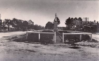 Whitehorse Historical Society Inc.
Photograph, War Memorial Mitcham, C1930
Black and white photo of War Memorial in Whitehorse Road,Mitcham.The much travelled (located and relocated) soldier has been placed n many since the end of WW1:|1. Centre of Whitehorse Road within reserve midway between Mitcham Road and Station Street (see photograph 562)|2. Closer to Mitcham Road and on the garden /lawns between Whitehorse Road (main throughway) and the northern service| road. (see NP562)|3. On his pedestal outside the Memorial Hall on the corner of Whitehorse Road and MacDowall Street.|4. Currently mounted in the gardens of Halliday Park in Mitcham Rd.war memorial mitcham