Showing 1339 items
matching growth
-
 Melton City Libraries
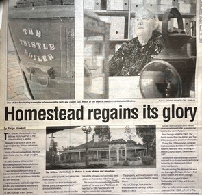
Newspaper, Homestead regains its glory, 2003
Built in the 1850s, The Willows was purchased by Melton Shire Council in a dilapidated state in 1972. At a time of rapid change and growth, the restoration of the homestead, its transformation into the headquarters of the Melton & District Historical Society and the creation of The Willows Historical Park saw the community embrace its past while simultaneously looking to the future.History of the Willows Homestead Melton and Moorabool Leader articlelocal identities, local architecture, local significant groups -
 Sunbury Family History and Heritage Society Inc.
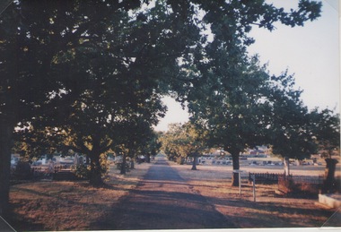
Photograph, Lydia Kenworth, Sunbury Cemetery, March 2001
The avenue of trees is along the main pathway of the old section of the Sunbury Cemetery. In 1862 the cemetery in Sunbury was laid out in Christian denominational sections. There were other sections set aside for paupers, heathens and pagans. Over the years the size of the cemetery has increased to keep pace with the growth of Sunbury's population.Sunbury Cemetery is one of the oldest cemeteries in the local area.A non-digital coloured photograph of an avenue of trees in a cemetery. The photograph is one of a collection of images that was entered in a photograph competition organised by the former Sunbury & District Heritage Association in March 2001.cemeteries, sunbury, sunbury cemetery -
 Port Melbourne Historical & Preservation Society
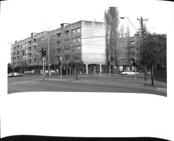
Photograph - Raglan Street Housing Commission Flats viewed from Ingles Street, Andrew U'REN, C. 1970s - 1980s
From a box of photographs in Nancy U'REN's papers used during research for her thesis, The Early Growth and Development of Sandridge (1976) and/or her book with Noel TURNBULL, A History of Port Melbourne (1983). The print was probably made by her son, Andrew U'REN, and he may have also taken the photograph.Black and white photograph of the blocks of Housing Commission flats at the corner of Ingles and Crockford Streets viewed from Ingles Street. Large white border at the bottom.A star in blue ink at the bottom left corner and details of photographic paper type and exposure details on the reverse.built environment - public housing, ingles street, crockford street, built environment - domestic, raglan street housing commission of victoria flats, nancy u'ren nee morris -
 Port Melbourne Historical & Preservation Society
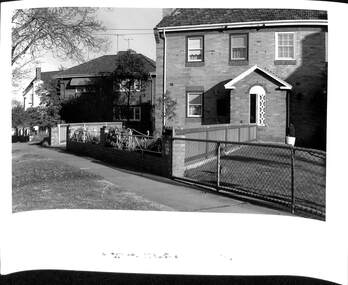
Photograph - Houses in Southward Avenue, Andrew U'REN, C. 1970s - 1980s
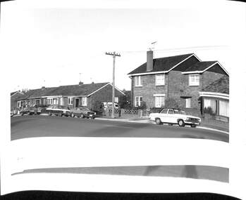
From a box of photographs in Nancy U'REN's papers used during research for her thesis, The Early Growth and Development of Sandridge (1976) and/or her book with Noel TURNBULL, A History of Port Melbourne (1983). The print was probably made by her son, Andrew U'REN, and he may have also taken the photograph.Black and white photograph of No 13 and No 11 Southward Avenue with other houses in the street also visible in the photograph.built environment - domestic, dunstan estate, southward avenue, nancy u'ren nee morris -
 Port Melbourne Historical & Preservation Society
Photograph - Houses in Williamstown Road, Andrew U'REN, C. 1970s - 1980s
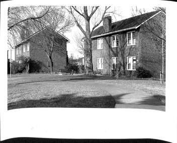
From a box of photographs in Nancy U'REN's papers used during research for her thesis, The Early Growth and Development of Sandridge (1976) and/or her book with Noel TURNBULL, A History of Port Melbourne (1983). The print was probably made by her son, Andrew U'REN, and he may have also taken the photograph.Black and white photograph of houses in Williamstown Road, Garden City. There is a large white border at the bottom and the top part of another image."OK" and "Williamstown rd" in blue ink on the front and type of photographic paper and exposure details on the reverse.built environment - domestic, williamstown road, garden city, nancy u'ren nee morris -
 Port Melbourne Historical & Preservation Society
Photograph - The Quartets, Williamstown Road, Andrew U'REN, C. 1970s - 1980s
From a box of photographs in Nancy U'REN's papers used during research for her thesis, The Early Growth and Development of Sandridge (1976) and/or her book with Noel TURNBULL, A History of Port Melbourne (1983). The print was probably made by her son, Andrew U'REN, and he may have also taken the photograph.Black and white photograph of The Quartets in Williamstown Road. There is a large white border at the bottom."OK" and "Williamstown rd elderly citizens flats" in blue ink on the front. Type of photographic paper and exposure details on the reverse.built environment - domestic, williamstown road, the quartets, nancy u'ren nee morris -
 Port Melbourne Historical & Preservation Society
Photograph - Corner The Boulevard and Beacon Road, Andrew U'REN, C. 1970s - 1980s
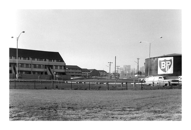
From a box of photographs in Nancy U'REN's papers used during research for her thesis, The Early Growth and Development of Sandridge (1976) and/or her book with Noel TURNBULL, A History of Port Melbourne (1983). The print was probably made by her son, Andrew U'REN, and he may have also taken the photograph.Black and white photograph of the corner of The Boulevard and Beacon Road from the foreshore looking towards the city. The flats are on the left and the BP refinery site is on the right. There is a large white border at the bottom.A star in blue ink on the front. Type of photographic paper and exposure details on the reverse.built environment - domestic, the boulevard, beacon road, bp australia, nancy u'ren nee morris -
 Surrey Hills Historical Society Collection
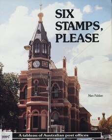
Book, Marc Fiddian, Six stamps please: a tableau of Australian post offices, 1989
Once a community's size and importance could be gauged from its post office. The post office, especially in the 19th century, reflected the growth and prosperity of its locality. The boom in post office building was from the mid-1860s to the early 1890s. Invariably a post office was built in a prime location, frequently on a street corner.This book provides a cross section of the various styles of post offices built in city, suburb and country town, and who the post offices serve around Australia. Softback book of 83 pages, with numerous black and white photos; post offices are described alphabetically by town.surrey hills post office, post offices, official buildings, architectural styles, (mr) marc fiddian -
 Stawell Historical Society Inc
Book, John Kingston, Beaters to Blitz's and Beyond - History of the Stawell Fire Brigades Group 1943-1993, 1993
This booklet was produced for the dinner held to celebrate the fifty years the Stawell fire Brigades Group has existed in its service to the community. It does not intend to be a definitive history of fire fighting in the area but it is hoped that it outlines the beginnings from which Stawell Fire Brigades Group originate, and its growth, as it developed over the years.Front Cover: Cream medium card with B/W photo of old truck in center. Title in bold black print above, other information below inc. Author Rear Cover Heavy Card.Beaters To Blitz's and Beyond. History of the Stawell Fire Brigades Group (Glenorchy- Richella Bush Fire Brigades Group) 1943-1993 John KIngstonstawell -
 Bendigo Historical Society Inc.
Newspaper - LONG GULLY HISTORY GROUP COLLECTION: CROSSLEY HISTORICAL GALLERY0
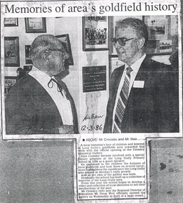
Copy of a newspaper article titled Memories of area's goldfield history. After becoming involved with a special history program at the Long Gully Primary School in 1984 as a guest speaker, Alan Crossley explained to the children the features of local goldfields and took them on several excursions highlighting the significance of the Long Gully area played in Bendigo's early growth. The school built up a collection of material of the long Gully area and the idea of a gallery was born. Accompanying photo shows Mr Crossley and the Regional Director of Education Mr Doug Weir at the opening of the gallery. Written on the photo is: taken 12-3-86.bendigo, history, long gully history group, the long gully history group - crossley historical gallery, long gully's goldfields, alan crossley, long gully primary school, mr doug weir -
 Melbourne Tram Museum
Newspaper, The Age, "Propping up private operators won't help public transport", "Analysis & Debate - The Fine Print", 25/06/2008 12:00:00 AM
Newspaper clipping from The Age, dated 25-6-2008 1 - Editorial titled "Propping up private operators won't help public transport" - looks at the history of privatisation or franchising, the consolidation of operators, growth in transport demand the lack of oversight, public interest and the lack of penalties on poor performance. 2 - Article by Clay Lucas, Analysis & Debate - The Fine Print" about the issue of new tender documents that had been leaked, issues of over crowding, potential bidders, fines for poor performance, fare evasion. Quotes John Brumby, Lynne Kosky, Terry Mulder and Greg Barber.trams, tramways, franchising, yarra trams, tenders, public transport, railways, privatisation -
 Royal Australian and New Zealand College of Obstetricians & Gynaecologists (RANZCOG)
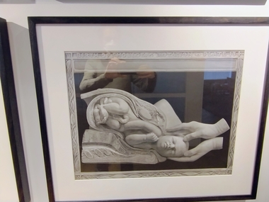
Print - Reproduction print of plate from 'Birth atlas', Maternity Center Association, 1943, Robert Latou Dickinson et al, Plate 13. Birth of shoulders rotation, 1943
A series of six prints showing various stages of labour, donated to the College in 2000.Black and white reproduction print of a plate from a book, enclosed in a wooden frame. Text at the top of the print reads 'BIRTH OF SHOULDERS ROTATION PLATE 13'. The plate depicts a detailed cross section image of a baby in the womb. Label attached to back of work reads: 'Robert Latou DICKINSON and Abram BELSKI/ Plate 13. Birth of shoulders rotation/From: Birth atlas: reproduction of twenty-four life size sculptures of fertilization, growth,/stages of labour and involution./New York: Maternity Center Association, 1943. 6th ed./Gift of St Georges Hospital, Kew, 2000'.BIRTH OF SHOULDERS ROTATION PLATE 13obstetric delivery -
 Royal Australian and New Zealand College of Obstetricians & Gynaecologists (RANZCOG)
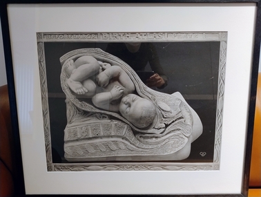
Print - Reproduction print of plate from 'Birth atlas', Maternity Center Association, 1943, Robert Latou Dickinson et al, Plate 8. Before labour, 1943
A series of six prints showing various stages of labour, donated to the College in 2000.Black and white reproduction print of a plate from a book, enclosed in a wooden frame. Text at the top of the print reads 'BEFORE LABOR | BIRTH ATLAS | PLATE 8'. The plate depicts a detailed cross section image of a baby in the womb. Label attached to back of work reads: 'Robert Latou DICKINSON and Abram BELSKI/ Plate 8. Before labour/From: Birth atlas: reproduction of twenty-four life size sculptures of fertilization, growth,/stages of labour and involution./New York: Maternity Center Association, 1943. 6th ed./Gift of St Georges Hospital, Kew, 2000'.BEFORE LABOR | BIRTH ATLAS | PLATE 8obstetric delivery -
 Seaworks Maritime Museum
Plaque
Small plaque with Korean writing in perspexKorean writing "Korea Maritime and Port Administration" verso "Vault Beyond the Seas/ on the 13th March 1977/ Park Chung Hee, President/ Our motto, presented by the President on the/ first anniversary of the founding of the Korea Maritime/ and Port Administration represents our mission and our/ inspiration to pace the dynamic economic growth of our/ Republic in joining the ranks of the great maritime/ countries of the world" "WMA 66" "PMA 0262" -
 Port Melbourne Historical & Preservation Society
Photograph - Methodist Church, Graham Street, Jack GOULD, 1950
From a box of photographs in Nancy U'REN's papers used during research for her thesis, The Early Growth and Development of Sandridge (1976) and/or her book with Noel TURNBULL, A History of Port Melbourne (1983). Probably taken by Jack GOULD. This image is different from the one that appears on p55 of A History of Port Melbourne. The church was demolished in the 1970s.Black and white photograph of Methodist Church in Graham Street.graham street, religion - wesleyan methodist church, nancy u'ren nee morris -
 Robin Boyd Foundation
Document - Manuscript, Robin Boyd, The Shanty Town at Tullamarine, 1971
Discusses the reasons for Sydney's and Melbourne's new airports. Discusses the transformation from picturesque landscape to a growth of unordered supplementary structures surrounding airports (motels, sheds, storage rooms, petrol stations, shopping mall). Boyd predicts this "shanty town" image will only get worse, and critiques the image of Australia first presented to international visitors.Original manuscript of an article published in "The Sunday Australian", 27.06.1971Typewritten (c copy), quarto, 8 pagesNumbered in 13 paragraphstullamarine airport, international airport, melbourne's shanty town, robin boyd, manuscript -
 Forests Commission Retired Personnel Association (FCRPA)
Increment borer
An increment borer is a specialised tool to extract a core sample of wood tissue from a living tree. The tool consists of a handle, an auger bit and a small, half circular metal tray (the core extractor) that fits inside the auger bit. The core sample can be used to count the rings, to reveal the age of the tree and its growth rate.Increment borer. The central core is stuck. AGN Mattison - Sweden #4333forest measurement, forests commission victoria (fcv) -
 Robin Boyd Foundation
Document - Manuscript, Robin Boyd, Imported Archi…
Boyd argues that Australia needs confidence in creative thinking so our products can cut through established formulas to contribute to our growth as a nation. He outlines four stages of architectural development in every community, and describes Canada in these terms. He posits that Australia overall is only at stage two (imported sophisticated), Brisbane/Hobart/Adelaide at stage one. Boyd argues the Australian dream of individual identity is impossible now, to move to stage 3 Australia needs to be encouraged to have confidence in Australian artists of all kinds, allowing creative people to flourish, be themselves. He indicates that Canberra is close to third stage, with architecture designed by international figures in 1960s but now Australian John Andrews brought out to do an architecturally creative office complex in Belconnen - Canberra, signalling growth of a national identity.Typewritten (c copy), pencil edits and additions, quarto, 7 pages - p12-18confidence in creative thinking, australian national identity, four stages in architectural development, canberra architecture, john andrews, robin boyd, manuscript -
 Bendigo Historical Society Inc.
Document - DAVID BANNEAR, THE GOLDFIELDS LANDSCAPE - PROPOSED TALK, 2/11/2023
The goldfields resulted in the almost complete denuding of trees for access to the gold bearing land, for firewood and for the tanning industry. The need for wood further increased with the advent of deep quartz mining that required timbers for shoring up the shafts and tunnels. At some point in time it became necessary for timber to be carted long distances to fulfil the need. Between 1878 and 1884, the government set up 5 nurseries to try and rectify the shortage of native softwoods and encouraged the growth of State plantations and the thinning of trees to encourage growth of those remaining. 1907 - Creswick School of Forestry and Forest Management was started 1919 Establishment of the Forests Commission and the planting of many pine plantations 1924 Establishment of the first fire spotting towers Forest management tasks became a main project for "Susso" recipients during the Great Depression and again for internees during WWII.An 8 page document by David Bannear about the various industries of the Bendigo Goldfields and their effects on terraforming the local environment david bannear, central goldfields -
 Kew Historical Society Inc
Plan, Studley Park Estate, 1910
Prue Sanderson, in her groundbreaking ‘City of Kew Urban Conservation Study : Volume 2 - Development History’ (1988), summarised the periods of urban development and subdivisions of land in Kew. The periods that she identified included 1845-1880, 1880-1893, 1893-1921, 1921-1933, 1933-1943, and Post-War Development. These periods were selected as they represented periods of rapid growth or decline in urban development. An obvious starting point for Sanderson’s groupings involved population growth and the associated economic cycles. These cycles also highlighted urban expansion onto land that was predominantly rural, although in other cases it represented the decline and breakup of large estates. A number of the plans in the Kew Historical Society’s collection can also be found in other collections, such as those of the State Library of Victoria and the Boroondara Library Service. A number are however unique to the collection.The Kew Historical Society collection includes almost 100 subdivision plans pertaining to suburbs of the City of Melbourne. Most of these are of Kew, Kew East or Studley Park, although a smaller number are plans of Camberwell, Deepdene, Balwyn and Hawthorn. It is believed that the majority of the plans were gifted to the Society by persons connected with the real estate firm - J. R. Mathers and McMillan, 136 Cotham Road, Kew. The Plans in the collection are rarely in pristine form, being working plans on which the agent would write notes and record lots sold and the prices of these. The subdivision plans are historically significant examples of the growth of urban Melbourne from the beginning of the 20th Century up until the 1980s. A number of the plans are double-sided and often include a photograph on the reverse. A number of the latter are by noted photographers such as J.E. Barnes.Coloured lithograph of a subdivision plan of the Studley Park Estate, bordered by Yarra, Willsmere Road and the Outer Circle Railway line. The estate was listed in 1910 and was the subject of a planning dispute between the developer and the Town of Kew in relation to flood levels and the suitability of the land for housing. In many cases the names of streets were subsequently changed. The layout was also affected by the creation of the Eastern Freeway. A newspaper report of the day described the subdivision as a: "GOLDEN OPPORTUNITY. We are pleased to submit for PRIVATE SALE that magnificent ESTATE, situated only 4 1/2 miles from the Melbourne General Post Office, STUDLEY PARK ESTATE. KF/NV. Doubtless the CHEAPEST LAND EVER OFFERED having extensive frontages to the prettiest spot on the River Yarra and the National Park, commanding lovely river and landscape views, and acknowledged to be the finest land available so close to the city. The PRICES ARE EXTREMELY MODERATE; The TERMS ARE SIMPLY MARVELLOUS. NO DEPOSIT. NO DEPOSIT. NO DEPOSIT. Allotments and prices to suit everyone."subdivision plans - kew, studley park estate -
 Kew Historical Society Inc
Plan, Studley Heights Estate, 1936
Pru Sanderson, in her groundbreaking ‘City of Kew Urban Conservation Study : Volume 2 - Development History’ (1988), summarised the periods of urban development and subdivisions of land in Kew. The periods that she identified included 1845-1880, 1880-1893, 1893-1921, 1921-1933, 1933-1943, and Post-War Development. These periods were selected as they represented periods of rapid growth or decline in urban development. An obvious starting point for Sanderson’s groupings involved population growth and the associated economic cycles. These cycles also highlighted urban expansion onto land that was predominantly rural, although in other cases it represented the decline and breakup of large estates. A number of the plans in the Kew Historical Society’s collection can also be found in other collections, such as those of the State Library of Victoria and the Boroondara Library Service. A number are however unique to the collection.Subdivision plans are historically important documents used as evidence of the growth of suburbs in Australia. They frequently provide information about when the land was sold on which a built structure was subsequently constructed as well as evidence relating to surveyors and real estate and financial agents. The numerous subdivision plans in the Kew Historical Society's collection represent working documents, ranging from the initial sketches made in planning a subdivision to printed plans on which auctioneers or agents listed the prices for which individual lots were sold. In a number of cases, the reverse of a subdivision plan in the collection includes a photograph of a house that was also for sale by the agent. These photographs provide significant heritage information relating house design and decoration, fencing and household gardens.The ‘Studley Heights Estate’ on the South Side of Studley Park Road was launched in 1936. The seventeen allotments in the subdivision fronted Hyton Crescent and Studley Park Road.subdivision plans - kew, studley heights estate -
![Monnington [Estate], 1935](/media/collectors/550653872162f11fb04854aa/items/5907eb86d0ce0c14e82385c8/item-media/5907ecafd0ce0c14e823e87f/item-fit-380x285.jpg) Kew Historical Society Inc
Kew Historical Society IncPlan - Subdivision Plan, Monnington [Estate], 1935, 1935
Pru Sanderson, in her groundbreaking ‘City of Kew Urban Conservation Study : Volume 2 - Development History’ (1988), summarised the periods of urban development and subdivisions of land in Kew. The periods that she identified included 1845-1880, 1880-1893, 1893-1921, 1921-1933, 1933-1943, and Post-War Development. These periods were selected as they represented periods of rapid growth or decline in urban development. An obvious starting point for Sanderson’s groupings involved population growth and the associated economic cycles. These cycles also highlighted urban expansion onto land that was predominantly rural, although in other cases it represented the decline and breakup of large estates. A number of the plans in the Kew Historical Society’s collection can also be found in other collections, such as those of the State Library of Victoria and the Boroondara Library Service. A number are however unique to the collection.Subdivision plans are historically important documents used as evidence of the growth of suburbs in Australia. They frequently provide information about when the land was sold on which a built structure was subsequently constructed as well as evidence relating to surveyors and real estate and financial agents. The numerous subdivision plans in the Kew Historical Society's collection represent working documents, ranging from the initial sketches made in planning a subdivision to printed plans on which auctioneers or agents listed the prices for which individual lots were sold. In a number of cases, the reverse of a subdivision plan in the collection includes a photograph of a house that was also for sale by the agent. These photographs provide significant heritage information relating house design and decoration, fencing and household gardens.The first subdivision of Monnington took place in 1935. At that time, Monnington and 10 new allotments were offered for sale bordering Adeney and Marshall Avenues. In this subdivision plan, Monnington is one of 13 lots for sale. The subdivision created the irregular land holding of Monnington today. The excision of southwest corner of Monninton was caused by the need to have regular allotments facing the curve in Marshall Avenue.monnington - adeney avenue -- kew (vic.), subdivision plans -- kew (vic.) -
 Kew Historical Society Inc
Plan - Subdivision Plan, Goldthorns House Estate, 1940
Pru Sanderson, in her groundbreaking ‘City of Kew Urban Conservation Study : Volume 2 - Development History’ (1988), summarised the periods of urban development and subdivisions of land in Kew. The periods that she identified included 1845-1880, 1880-1893, 1893-1921, 1921-1933, 1933-1943, and Post-War Development. These periods were selected as they represented periods of rapid growth or decline in urban development. An obvious starting point for Sanderson’s groupings involved population growth and the associated economic cycles. These cycles also highlighted urban expansion onto land that was predominantly rural, although in other cases it represented the decline and breakup of large estates. A number of the plans in the Kew Historical Society’s collection can also be found in other collections, such as those of the State Library of Victoria and the Boroondara Library Service. A number are however unique to the collection.The Kew Historical Society collection includes almost 100 subdivision plans pertaining to suburbs of the City of Melbourne. Most of these are of Kew, Kew East or Studley Park, although a smaller number are plans of Camberwell, Deepdene, Balwyn and Hawthorn. It is believed that the majority of the plans were gifted to the Society by persons connected with the real estate firm - J. R. Mathers and McMillan, 136 Cotham Road, Kew. The Plans in the collection are rarely in pristine form, being working plans on which the agent would write notes and record lots sold and the prices of these. The subdivision plans are historically significant examples of the growth of urban Melbourne from the beginning of the 20th Century up until the 1980s. A number of the plans are double-sided and often include a photograph on the reverse. A number of the latter are by noted photographers such as J.E. Barnes.The first subdivision of Goldthorns created the Goldthorns Hill Estate. Following that subdivision, seven additional lots were offered between Normanby Road, Argyle Road and Lady Loch’s Drive on the proviso that the estate, including Goldthorns was not sold as a single lot. The subdivision plan advises that the lots are situated in one of the most charming and popular residential areas in Kew and is surrounded by modern homes. Typically, the subdivision plan proposes the advantage of its proximity to Cotham Road and the tram to Collins Street. Because of the elevation of Goldthorns, much is made of the ‘bright, sunny and extensive outlook to the Northern Ranges’ and that it overlooks the Yarra Valley. One of the more interesting aspects of the plan is that it shows the outline of Goldthorns in the mid to late 1920s. Its profile today remains virtually the same."Goldthorns" House Estate at topsubdivision plans - kew, goldthorns house estate -
 Kew Historical Society Inc
Plan, Sydney Arnold Best & Co, Field Place, Kew, c.1929
Pru Sanderson, in her groundbreaking ‘City of Kew Urban Conservation Study : Volume 2 - Development History’ (1988), summarised the periods of urban development and subdivisions of land in Kew. The periods that she identified included 1845-1880, 1880-1893, 1893-1921, 1921-1933, 1933-1943, and Post-War Development. These periods were selected as they represented periods of rapid growth or decline in urban development. An obvious starting point for Sanderson’s groupings involved population growth and the associated economic cycles. These cycles also highlighted urban expansion onto land that was predominantly rural, although in other cases it represented the decline and breakup of large estates. A number of the plans in the Kew Historical Society’s collection can also be found in other collections, such as those of the State Library of Victoria and the Boroondara Library Service. A number are however unique to the collection.The Kew Historical Society collection includes almost 100 subdivision plans pertaining to suburbs of the City of Melbourne. Most of these are of Kew, Kew East or Studley Park, although a smaller number are plans of Camberwell, Deepdene, Balwyn and Hawthorn. It is believed that the majority of the plans were gifted to the Society by persons connected with the real estate firm - J. R. Mathers and McMillan, 136 Cotham Road, Kew. The Plans in the collection are rarely in pristine form, being working plans on which the agent would write notes and record lots sold and the prices of these. The subdivision plans are historically significant examples of the growth of urban Melbourne from the beginning of the 20th Century up until the 1980s. A number of the plans are double-sided and often include a photograph on the reverse. A number of the latter are by noted photographers such as J.E. Barnes.An unnamed subdivision in Studley Park including five lots for sale in Studley Park Road, Highfield Grove and Tara Avenue. Unidentified on the plan, but clearly existing, are the Henty family mansion of Field Place and Tara Hall in Studley Park Road. The first attempted subdivision of Tara Hall was advertised in 1927 in which Lots 5, 6 and 7 in this plan were also advertised. Unusually, Lot 2 in Studley Park Road was created from the northern part of the Henty mansion, rather than Tara Hall. In the subdivision, lots were advertised at varying prices, with the highest price for land being Lot 2 in Studley Park Road. The plan notes that only one villa is to be allowed on each allotment.subdivision plans - kew, field place subdivision -- studley park – kew (vic.), highfield grove – kew (vic.), tara avenue – kew (vic.) -
 Kew Historical Society Inc
Plan - Subdivision Plan, Altyre Estate, 1920, 1920
Pru Sanderson, in her groundbreaking ‘City of Kew Urban Conservation Study : Volume 2 - Development History’ (1988), summarised the periods of urban development and subdivisions of land in Kew. The periods that she identified included 1845-1880, 1880-1893, 1893-1921, 1921-1933, 1933-1943, and Post-War Development. These periods were selected as they represented periods of rapid growth or decline in urban development. An obvious starting point for Sanderson’s groupings involved population growth and the associated economic cycles. These cycles also highlighted urban expansion onto land that was predominantly rural, although in other cases it represented the decline and breakup of large estates. A number of the plans in the Kew Historical Society’s collection can also be found in other collections, such as those of the State Library of Victoria and the Boroondara Library Service. A number are however unique to the collection.The Kew Historical Society collection includes almost 100 subdivision plans pertaining to suburbs of the City of Melbourne. Most of these are of Kew, Kew East or Studley Park, although a smaller number are plans of Camberwell, Deepdene, Balwyn and Hawthorn. It is believed that the majority of the plans were gifted to the Society by persons connected with the real estate firm - J. R. Mathers and McMillan, 136 Cotham Road, Kew. The Plans in the collection are rarely in pristine form, being working plans on which the agent would write notes and record lots sold and the prices of these. The subdivision plans are historically significant examples of the growth of urban Melbourne from the beginning of the 20th Century up until the 1980s. A number of the plans are double-sided and often include a photograph on the reverse. A number of the latter are by noted photographers such as J.E. Barnes.The Altyre Estate was advertised for sale by auction in 1920. A colour lithograph in the State Library of Victoria, in contrast to this monochrome version, notes the proximity of the subdivision to the Auburn Heights Bowling Club and to a range of transport options. The subdivision included fifty-one allotments as well as the original house ‘Altyre’ in Barkers Road. This version includes the amounts paid as deposit on a number of lots.subdivision plans - kew, altyre estate – kew (vic), barkers road – kew (vic), walsh street – kew (vic), ross street – kew (vic), loxton street – kew (vic), mount street – kew (vic), auburn heights bowling club, altyre -
 Kew Historical Society Inc
Plan - Subdivision Plan, Wimba Estate, Kew, c.1925-c.1929, ca. 1925-ca. 1929
Pru Sanderson, in her groundbreaking ‘City of Kew Urban Conservation Study : Volume 2 - Development History’ (1988), summarised the periods of urban development and subdivisions of land in Kew. The periods that she identified included 1845-1880, 1880-1893, 1893-1921, 1921-1933, 1933-1943, and Post-War Development. These periods were selected as they represented periods of rapid growth or decline in urban development. An obvious starting point for Sanderson’s groupings involved population growth and the associated economic cycles. These cycles also highlighted urban expansion onto land that was predominantly rural, although in other cases it represented the decline and breakup of large estates. A number of the plans in the Kew Historical Society’s collection can also be found in other collections, such as those of the State Library of Victoria and the Boroondara Library Service. A number are however unique to the collection.Subdivision plans are historically important documents used as evidence of the growth of suburbs in Australia. They frequently provide information about when the land was sold on which a built structure was subsequently constructed as well as evidence relating to surveyors and real estate and financial agents. The numerous subdivision plans in the Kew Historical Society's collection represent working documents, ranging from the initial sketches made in planning a subdivision to printed plans on which auctioneers or agents listed the prices for which individual lots were sold. In a number of cases, the reverse of a subdivision plan in the collection includes a photograph of a house that was also for sale by the agent. These photographs provide significant heritage information relating house design and decoration, fencing and household gardens.In 1925, the City of Kew called for tenders for the construction of Wimba Avenue, Cadow Street and Lalla Street. Subsequent advertisements for the sale of land in Wimba Avenue continued from 1926 to 1929. The 18 lots (and a further five allotments on the eastern side of the street) offered for sale were unofficially described in the subdivision plan as the ‘Wimba Estate’. These lots began in Park Hill Road and extended almost to Cotham Road. The subdivision took its name from the house ‘Wimba’ in Cotham Road, which may have formed the southern boundary of the subdivision. (Wimba, at 235 Cotham Road was constructed between 1862-70). The Plan highlights the proximity and advantage of ‘electric’ trams in Cotham and Glenferrie Roads, and the Kew and Glenferrie Railway Stations. An oddity in the Plan is the reference to the electric tram terminus at Burke Road, given that the tramline had already been extended to Mont Albert in 1916.wimba estate, subdivision plans - kew, parkhill road – kew (vic.), normanby road – kew (vic.), wimba avenue – kew (vic.) -
 Kew Historical Society Inc
Plan - Subdivision Plan, Summerhill Estate, 1920-1940
Pru Sanderson, in her groundbreaking ‘City of Kew Urban Conservation Study : Volume 2 - Development History’ (1988), summarised the periods of urban development and subdivisions of land in Kew. The periods that she identified included 1845-1880, 1880-1893, 1893-1921, 1921-1933, 1933-1943, and Post-War Development. These periods were selected as they represented periods of rapid growth or decline in urban development. An obvious starting point for Sanderson’s groupings involved population growth and the associated economic cycles. These cycles also highlighted urban expansion onto land that was predominantly rural, although in other cases it represented the decline and breakup of large estates. A number of the plans in the Kew Historical Society’s collection can also be found in other collections, such as those of the State Library of Victoria and the Boroondara Library Service. A number are however unique to the collection.The Kew Historical Society collection includes almost 100 subdivision plans pertaining to suburbs of the City of Melbourne. Most of these are of Kew, Kew East or Studley Park, although a smaller number are plans of Camberwell, Deepdene, Balwyn and Hawthorn. It is believed that the majority of the plans were gifted to the Society by persons connected with the real estate firm - J. R. Mathers and McMillan, 136 Cotham Road, Kew. The Plans in the collection are rarely in pristine form, being working plans on which the agent would write notes and record lots sold and the prices of these. The subdivision plans are historically significant examples of the growth of urban Melbourne from the beginning of the 20th Century up until the 1980s. A number of the plans are double-sided and often include a photograph on the reverse. A number of the latter are by noted photographers such as J.E. Barnes.The Summerhill Estate was a subdivision in Glen Iris of 24 ‘choice allotments’. The lots were primarily on both sides of Dillon Grove. Other lots at each end of the subdivision faced Margaret Street and Summerhill Road. It was from the latter that the subdivision took its advertised title. The lots were originally advertised for £10 deposit with 20 subsequent payments over five years. Pencilled on the printed plan is a change to the deposit required; a reduction to 20/-. Annotations indicate that the new deposits ranged from 30/- to 45/-. The most expensive lots faced Summerhill Road. This subdivision plan is unusual in that the front and rear of the card are for subdivisions in different localities.subdivision plans - glen iris, summerhill estate -
 Kew Historical Society Inc
Plan - Subdivision Plan, Old Kew Golf Links Estate - Third Section, 1920-1929
Pru Sanderson, in her groundbreaking ‘City of Kew Urban Conservation Study : Volume 2 - Development History’ (1988), summarised the periods of urban development and subdivisions of land in Kew. The periods that she identified included 1845-1880, 1880-1893, 1893-1921, 1921-1933, 1933-1943, and Post-War Development. These periods were selected as they represented periods of rapid growth or decline in urban development. An obvious starting point for Sanderson’s groupings involved population growth and the associated economic cycles. These cycles also highlighted urban expansion onto land that was predominantly rural, although in other cases it represented the decline and breakup of large estates. A number of the plans in the Kew Historical Society’s collection can also be found in other collections, such as those of the State Library of Victoria and the Boroondara Library Service. A number are however unique to the collection.The Kew Historical Society collection includes almost 100 subdivision plans pertaining to suburbs of the City of Melbourne. Most of these are of Kew, Kew East or Studley Park, although a smaller number are plans of Camberwell, Deepdene, Balwyn and Hawthorn. It is believed that the majority of the plans were gifted to the Society by persons connected with the real estate firm - J. R. Mathers and McMillan, 136 Cotham Road, Kew. The Plans in the collection are rarely in pristine form, being working plans on which the agent would write notes and record lots sold and the prices of these. The subdivision plans are historically significant examples of the growth of urban Melbourne from the beginning of the 20th Century up until the 1980s. A number of the plans are double-sided and often include a photograph on the reverse. A number of the latter are by noted photographers such as J.E. Barnes.When the old Kew Golf Links was subdivided in the mid 1920s, the developers were able to break the sale into sections. The third section included eighty lots. The lots faced Kilby Road, Kodak Avenue, Belford Road, Baker Avenue, Mathers Avenue, and White Avenue. [Kodak Avenue was renamed Page Avenue at a later date].The ‘Kew Conservation Study (1988) notes that ‘On the subdivision plan, Kodak’s involvement is commemorated by the naming of the streets after Company directors, and their decision to not proceed with the construction of the factory is explained as a response to the increase in the value of the land. This explanation may have been Estate Agent’s hyperbole, as the Kodak Company records suggest that the land, with its wide creek gully, was unsuitable and too small for its purposes.subdivision plans - kew, old kew golf links estate - third section -
 Kew Historical Society Inc
Plan - Subdivision Plan, Birdwood Estate, 1920
Pru Sanderson, in her groundbreaking ‘City of Kew Urban Conservation Study : Volume 2 - Development History’ (1988), summarised the periods of urban development and subdivisions of land in Kew. The periods that she identified included 1845-1880, 1880-1893, 1893-1921, 1921-1933, 1933-1943, and Post-War Development. These periods were selected as they represented periods of rapid growth or decline in urban development. An obvious starting point for Sanderson’s groupings involved population growth and the associated economic cycles. These cycles also highlighted urban expansion onto land that was predominantly rural, although in other cases it represented the decline and breakup of large estates. A number of the plans in the Kew Historical Society’s collection can also be found in other collections, such as those of the State Library of Victoria and the Boroondara Library Service. A number are however unique to the collection.The Kew Historical Society collection includes almost 100 subdivision plans pertaining to suburbs of the City of Melbourne. Most of these are of Kew, Kew East or Studley Park, although a smaller number are plans of Camberwell, Deepdene, Balwyn and Hawthorn. It is believed that the majority of the plans were gifted to the Society by persons connected with the real estate firm - J. R. Mathers and McMillan, 136 Cotham Road, Kew. The Plans in the collection are rarely in pristine form, being working plans on which the agent would write notes and record lots sold and the prices of these. The subdivision plans are historically significant examples of the growth of urban Melbourne from the beginning of the 20th Century up until the 1980s. A number of the plans are double-sided and often include a photograph on the reverse. A number of the latter are by noted photographers such as J.E. Barnes.Bordering Burke Road, the Birdwood Estate included a subdivision of 34 lots on either side of Birdwood Street, Balwyn. Six of the lots faced Burke Road. At the other end of the subdivision a line would indicate that a creek once bordered the subdivision. Lots were advertised for sale at a low figure on five-year terms. Purchasers could pay off the balance in twenty quarterly instalments (i.e. over five years).subdivision plans - balwyn, birdwood estate -
 Kew Historical Society Inc
Plan - Subdivision Plan, Bonnie Doon Estate, c.1908
Pru Sanderson, in her groundbreaking ‘City of Kew Urban Conservation Study : Volume 2 - Development History’ (1988), summarised the periods of urban development and subdivisions of land in Kew. The periods that she identified included 1845-1880, 1880-1893, 1893-1921, 1921-1933, 1933-1943, and Post-War Development. These periods were selected as they represented periods of rapid growth or decline in urban development. An obvious starting point for Sanderson’s groupings involved population growth and the associated economic cycles. These cycles also highlighted urban expansion onto land that was predominantly rural, although in other cases it represented the decline and breakup of large estates. A number of the plans in the Kew Historical Society’s collection can also be found in other collections, such as those of the State Library of Victoria and the Boroondara Library Service. A number are however unique to the collection.The Kew Historical Society collection includes almost 100 subdivision plans pertaining to suburbs of the City of Melbourne. Most of these are of Kew, Kew East or Studley Park, although a smaller number are plans of Camberwell, Deepdene, Balwyn and Hawthorn. It is believed that the majority of the plans were gifted to the Society by persons connected with the real estate firm - J. R. Mathers and McMillan, 136 Cotham Road, Kew. The Plans in the collection are rarely in pristine form, being working plans on which the agent would write notes and record lots sold and the prices of these. The subdivision plans are historically significant examples of the growth of urban Melbourne from the beginning of the 20th Century up until the 1980s. A number of the plans are double-sided and often include a photograph on the reverse. A number of the latter are by noted photographers such as J.E. Barnes.The subdivision advertised as the Bonnie Doon Estate in Greensborough was first advertised in 1908. At that stage, the new subdivision included 15 allotments of between one and four acres. By the time the subdivision plan in the Kew Collection was created, only 12 lots of between ¾ and 2½ acres remained. Both the State Library and Kew plans emphasise the distance to the city being 13½ miles, which could be reached by train on weekdays and weekends. Unusually, the plan describes the suitability of lots as locations for ‘Week-end Homes’. Correspondingly, the train line is described as ‘The Holiday Resort for the Northern Suburbs’.bonnie doona estate, subdivision plans - greensborough