Showing 578 items
matching healesville
-
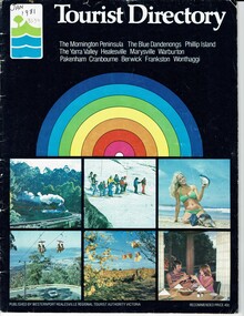 Phillip Island and District Historical Society Inc.
Booklet, Tourist Directory 1981 and Guide to Phillip Island & surrounds 1995
HistoricalLarge black booklet with brightly coloured cover with tourist photos. Inside is black type with descriptions, maps, advertisements and photos. Guide is smaller with white and red writing and maps. Inside it has red writing on history, climate and information on Phillip Island and small advertisements of attractions.Tourist Directory, Published by Westernport Healesville Regional Tourist Authority Victoria. Printed by Standard Newspapers, Cheltenham. Guide to Phillip Island & surrounds.Phillip Island Information Centre RMB 1305 Newhaven.tourism, tourist brochure, accomodation, restaurants, map of phillip island -
 Ringwood and District Historical Society
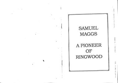
Document - Samuel Maggs A Pioneer of Ringwood, Samuel Maggs A Pioneer of Ringwood 1851-1942
The Maggs family were well known residents of Ringwood3 A4 pages of printed history including family trees, voyage to Australia, time in Blackburn and Ringwood. A facsimile transmission from the Healesville Library. Additional material Written by Russ Haines President of RDHS 2022. -
 Whitehorse Historical Society Inc.
Map, Facilities provided for you, 1970
Map of the City of Nunawading showing main roads and reserves with numbers indicating location of Halls, Infant Welfare Centres, Elderly Citizens Clubrooms and other major Council facilities. Route of proposes Healesville Freeway marked.Map of the City of Nunawading showing main roads and reserves with numbers indicating location of Halls, Infant Welfare Centres, Elderly Citizens Clubrooms and other major Council facilities. Route of proposes Healesville Freeway marked.Map of the City of Nunawading showing main roads and reserves with numbers indicating location of Halls, Infant Welfare Centres, Elderly Citizens Clubrooms and other major Council facilities. Route of proposes Healesville Freeway marked.city of nunawading, maps, maternal and child health centres, senior citizens centres, healesville freeway, parks and reserves -
 Healesville Sanctuary Heritage Centre
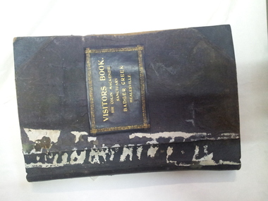
visitors' book 1, Visitors' Book, January 1934
This book was used as a visitors' book prior to the official opening of the Healesville Sanctuary. This first entry was 6 March 1934 and the last 18 March 1959.A very early Visitors' Book for Sir Colin MacKenzie Sanctuary. Black hardcovers with gold leaf printed label. Cloth bound. End papers in marble effect.Names of the Sir Colin MacKenzie Sanctuary Committee on title page. Includes signatures of Sir Colin MacKenzie and Lady Winifred MacKenzie, Julian Huxley, Keith and Elizabeth Murdoch, 1956 Olympic teams etc. visitors, committee-of-management, healesville-shire-council, colin-mackenzie-sanctuary-committee -
 Greensborough Historical Society
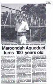
Newspaper clipping, Diamond Valley Leader, Maroondah Aqueduct turns 100 years old, 1991c
Aqueduct of 66 km built between 1886 and 1891 between Watts River near Healesville and Preston Reservoir. Parts have been replaced by pipes.The aqueduct formed a major link in Melbourne's water distribution system after supplies from Yan Yean Reservoir were considered insufficient in the 1870s.Photographic copy, text with photo of Russell Yeomansmaroondah aqueduct, russell yeomans -
Whitehorse Historical Society Inc.
Drawing - Illustration, Barak
Picture of the Aboriginal, Barak, who was present when Batman signed the agreement with the Aborigines acquiring the land for the site of Melbourne.Picture of the Aboriginal, Barak, who was present when Batman signed the agreement with the Aborigines acquiring the land for the site of Melbourne. Barak later lived at Coranderk Aboriginal Reserve near Healesville. Taken from 'Lilydale' by Marian Aveling.Picture of the Aboriginal, Barak, who was present when Batman signed the agreement with the Aborigines acquiring the land for the site of Melbourne.aborigines, barak, aveling, marian -
 Marysville & District Historical Society
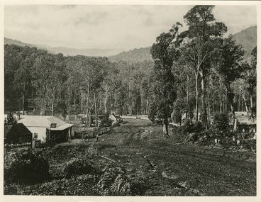
Photograph (Item) - Black and white photograph, Nicholas John Caire, c1880-1884
A copy of an early black and white photograph of Murchison Street in Marysville in Victoria taken by Nicholas John Caire.A copy of an early black and white photograph of Murchison Street in Marysville in Victoria taken by Nicholas John Caire. Murchison Street was named for Roderick Impey Murchison who was one of the most distinguished geologists of the 19th century. His liberality and social position plus the pride he took in his science were of immense value in furthering the cause of learning in Britain. Nicholas John Caire was born in 1837 in Guernsey. He arrived in Adelaide about 1860 along with his parents who encouraged his early interest in photography. He opened a studio in Adelaide in 1867 after traveling extensively throughout the Gippsland taking photographs. After marrying in 1870 he moved to Talbot in Victoria until 1876 when he opened a studio in the Royal Arcade in Melbourne. After 1885 Nicholas John Caire gave up his city work and made his home in South Yarra and devoted the rest of his life to outdoor photography, specializing in the bush, the gullies, and the mountains of south-eastern Victoria. LES HARSANT/ HEALESVILLE Entrance to Marysville/ from Nicholas Caire photo - c.1880-84 See Pitkethly, N.J. Caire, Landscape Photographer Pithkethly, Rosanna, Vic. 1988; plate 17murchison street, marysville, victoria, nicholas john caire, roderick impey murchison, geology, geologist -
 Greensborough Historical Society
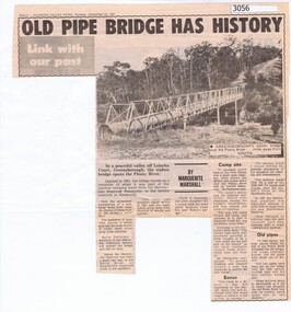
Newspaper Clipping, Diamond Valley News, Old pipe bridge has history, by Marguerite Marshall, 1891o
The aqueduct siphon bridge over the Plenty River, opened in 1891, was part of the pipeline bringing water from the service reservoir at Healesville, prior to the construction of the Maroondah Reservoir.News article, black and white text and photograph.aqueduct pipe bridge greensborough -
 Mont De Lancey
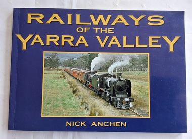
Book, Nick Anchen, Railways of the Yarra Valley, 2010
The railway reached Lilydale in 1882, Healesville in 1889 and Warburton in 1901 linking the area to Melbourne. Sawmillers and farmers prospered, as well as tourists visiting the region.A blue covered book of the Railways of the Yarra Valley with a photograph on the front cover of the last steam train from Warburton in August 1965 and the back cover showing an old locomotive 'Little Yarra' in 1913. There is historical text and maps with black and white and coloured photographs of the railways and of the area.Pp.96.non-fictionThe railway reached Lilydale in 1882, Healesville in 1889 and Warburton in 1901 linking the area to Melbourne. Sawmillers and farmers prospered, as well as tourists visiting the region. trains, rail vehicles, australian history, yarra valley -
 Eltham District Historical Society Inc
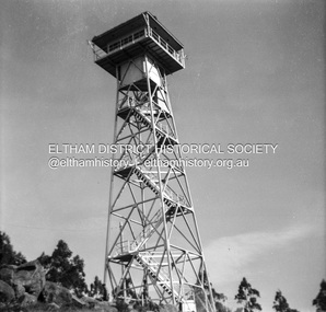
Photograph - Negative, Lewis Tulk, Fire Lookout Tower, c.May 1957
Fire lookout tower possibly situated at Mt Hickey near Seymour (Tallarook Ranges) or Mt St Leonard (Heaslesville)Print copy stamped "17" on reverselewis tulk collection, fire lookout tower, healesville, mt hickey, mt st leonard, seymour -
Marysville & District Historical Society
Document (Item) - Newspaper article, The Argus, New Tourist Road. Marysville to Wood's Point Magnificent Forest Scenery, 02-1924
A newspaper article regarding the opening of the Marysville-Wood's Point Road in February 1924.A newspaper article regarding the opening of the Marysville-Wood's Point Road in February 1924. The Marysville-Woods Point Road was originally part of the Yarra Track, constructed in the early 1860s to provide access between Healesville and the Woods Point Goldfields. Despite the steep terrain and engineering difficulties, the Yarra Track soon became a busy route used by pack horses, horse-drawn drays, and wagons. Today this sealed mountain road is a popular scenic drive between Marysville and Warburton.marysville-wood's point road, yarra track, healesville, wood's point goldfields, warburton, the argus -
 Marysville & District Historical Society
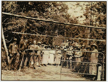
Photograph (Item) - Black and white photograph, 05-02-1924
An early black and white photograph of the ceremonial re-opening of the Marysville-Wood's Point Road in 1924.An early black and white photograph of the ceremonial re-opening of the Marysville-Wood's Point Road in 1924. The Marysville-Woods Point Road was originally part of the Yarra Track, constructed in the early 1860s to provide access between Healesville and the Woods Point Goldfields. Despite the steep terrain and engineering difficulties, the Yarra Track soon became a busy route used by pack horses, horse-drawn drays, and wagons. Today this sealed mountain road is a popular scenic drive between Marysville and Warburton.F.J. Barton Family Collectionmarysville-wood's point road, marysville, wood's point goldfields, healesville, yarra track, warburton -
 Marysville & District Historical Society
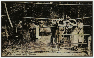
Photograph (Item) - Black and white photograph, 05-02-1924
An early black and white photograph of the ceremonial re-opening of the Marysville-Wood's Point Road in 1924.An early black and white photograph of the ceremonial re-opening of the Marysville-Wood's Point Road in 1924. The Marysville-Woods Point Road was originally part of the Yarra Track, constructed in the early 1860s to provide access between Healesville and the Woods Point Goldfields. Despite the steep terrain and engineering difficulties, the Yarra Track soon became a busy route used by pack horses, horse-drawn drays, and wagons. Today this sealed mountain road is a popular scenic drive between Marysville and Warburton.F.J. Barton Family Collectionmarysville-wood's point road, marysville, wood's point goldfields, healesville, yarra track, warburton -
 Marysville & District Historical Society
Photograph (Item) - Black and white photograph, 05-02-1924
An early black and white photograph of the ceremonial re-opening of the Marysville-Wood's Point Road in 1924.An early black and white photograph of the ceremonial re-opening of the Marysville-Wood's Point Road in 1924. The Marysville-Woods Point Road was originally part of the Yarra Track, constructed in the early 1860s to provide access between Healesville and the Woods Point Goldfields. Despite the steep terrain and engineering difficulties, the Yarra Track soon became a busy route used by pack horses, horse-drawn drays, and wagons. Today this sealed mountain road is a popular scenic drive between Marysville and Warburton.F.J. Barton Family Collectionmarysville-wood's point road, marysville, wood's point goldfields, healesville, yarra track, warburton -
 Wangaratta Art Gallery
Painting, Elaine Burge, Forest Ferns At Healseville, 1983
Rural City of Wangaratta Collection. Purchased with funds from the Wangaratta Arts Council.A rectangular landscape of forest ferns painted in oil using shades of green, brown, and blue.Obverse: Elaine Burge/ (bottom right corner)wangaratta art gallery, elaine burge, landscape, forest, healesville, painting -
 Uniting Church Archives - Synod of Victoria
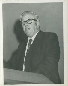
Photograph, Rev. John Cousins, undated c.1970s
John L. Cousins: Born 1909, died 1977. Ordained 1939. Eltham, Croxton, Merbein, Cemntral Mission, Healesville, Hobart, Devonport, Oakleigh, Box Hill (to 1974), Dandenong.B & W photograph of Rev John Cousins standing at a lectern or pulpit, dressed in suit and tie. White hair, wearing glasses."Rev. John Cousins, Box Hill" -
 Mt Dandenong & District Historical Society Inc.
Photograph, Mountain Grange and Great Barn Kalorama
Copy of a postcard titled "Looking Towards Healesville". View taken from "Cherry Farm" hill looking across farm (now the Kalorama Memorial Reserve), which was the property of Thomas and Eliza Hand. Location recognised because of likeness to a painting.eliza hand, mountain grange, thomas hand -
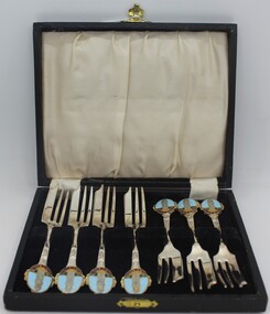 Ringwood and District Historical Society
Souvenir - Tableware, Souvenir of Ringwood Memorial Clocktower - cake forks 1970s
The spoons belonged to Mayor of Ringwood Alan Beattie Henderson 1978-79 and a Councillor from1976-1995. Purchased at the Healesville Op Shop in May 2014. Donated by the Askew and Small families of Ringwood.8 silver plated cake forks with enamel picture of Ringwood Memorial Clocktower on handle in dark brown case with black velvet base for the forks and white satin on the inner lid. Fastened with gold clip on frontPitcher melb. slv. plate -
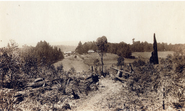
![Scene from the Black Spur / [by] Nicholas Caire, circa 1876](/media/collectors/550653872162f11fb04854aa/items/577b5403d0cdd10948cd5b81/item-media/577b5470d0cdd10948cda270/item-fit-380x285.jpg) Kew Historical Society Inc
Kew Historical Society IncPhotograph, Anglo-Australasian Photographic Company, Scene from the Black Spur, c. 1876
Nicholas Caire was born on Guernsey in the Channel Islands in 1837. He arrived in Adelaide with his parents in about 1860. In 1867, following photographic journeys in Gippsland, he opened a studio in Adelaide. From 1870 to 1876 he lived and worked in Talbot in Central Victoria. In 1876 he purchased T. F. Chuck's studios in the Royal Arcade Melbourne. In 1885, following the introduction of dry plate photography, he began a series of landscape series, which were commercially successful. As a photographer, he travelled extensively through Victoria, photographing places few of his contemporaries had previously seen. He died in 1918. Reference: Jack Cato, 'Caire, Nicholas John (1837–1918)', Australian Dictionary of Biography.An original, rare photograph from the series 'Views of Victoria: General Series' by the photographer, Nicholas Caire (1837-1918). The series of 60 photographs that comprise the series was issued c. 1876 and reinforced a neo-Romantic view of the Australian landscape to which a growing nationalist movement would respond. Nicholas Caire was active as a photographer in Australia from 1858 until his death in 1918. His vision of the Australian bush and pioneer life had a counterpart in the works of Henry Lawson and other nationalist poets, authors and painters.Views of Victoria (General Series) No.27 / ‘Scene from the Black Spur’ / Albumen silver photograph mounted on boardOn Reverse: ‘The scene which this illustration represents is taken from one of the slopes of the Black Spur Hill, on the Great Dividing Range of Mountains, and is characteristic of the scenery to be found in most parts of the beautiful and romantic districts of Fernshawe and Healesville.’nicholas caire (1837-1918), australia - landscape photography -
 Eltham District Historical Society Inc
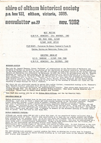
Newsletter, Newsletter, No. 27 November 1982
Contents: • November meeting – Film night: featuring Dr. Donald Thomson’s films of Central Australian Aboriginal tribal life • Christmas break-up • Eltham Community Festival • “Healesville – History in the hills” The Shire of Eltham Historical Society was formed in October 1967. The first newsletter of the Society was issued May 1978 and has been published continuously ever since on a bi-monthly basis. With the cessation of the Shire of Eltham in late 1994, the Society's name was revised to Eltham District Historical Society and this name first appeared with issue No. 103, July 1995. The collection of the Society's newsletters provides a valuable resource on the history of the Society's activities, office bearers and committee members, guest speakers and subjects of historical interest pertinent to the former Shire of Eltham and the Eltham District.A4 photocopied newsletter distributed to membersnewsletter, eltham district historical society, shire of eltham historical society -
 Bialik College
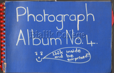
Booklet (item) - Scrapbook of photographs, c. 1980s, c. 1980s
Scrapbook of photographs and hand-written captions, c. 1980s. Includes 'Creation of the world' display, students eating potatoes, sports day and an excursion to Healesville Sanctuary. Please contact [email protected] to request access to this record.sport -
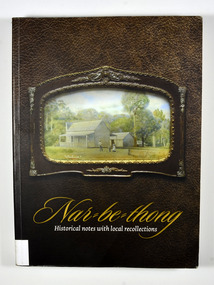 Marysville & District Historical Society
Book, Narbethong-Historical notes with local recollections, 2013
A history of Narbethong taken from recollections of local residentsPaperback. Front cover has a photograph of a painting of 'Lucknow', a farm which was owned by the Yeates Family. Back cover has a black and white photograph of a lady standing next to a wooden sign post showing the Acheron Way and the distances to Marysville, Warburton, Narbethong and Healesville.Stamp of the Marysville & District / Historical Society Inc / P.O. Box 22 / Marysville 3779narbethong, history, victoria, australia, local history -
Whitehorse Historical Society Inc.
Article, Farm digs in against closure, 2013
Land reserved for Healesville Freeway is at risk of being broken up for housing.Land reserved for Healesville Freeway is at risk of being broken up for housing. Some of the area is used at present for a farm run by NADRASCA, and other land is the nature reserve, Bellbird Dell. More than 1500 protested against the closure to local MP Shaun Leane.Land reserved for Healesville Freeway is at risk of being broken up for housing. healesville freeway reservation, bellbird dell, nadrasca, leane, shaun, vermont, koedyk, gus, turner, raeoni, kayne, rodney, basic, peter, vicroads -
 Eltham District Historical Society Inc
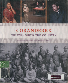
Book, Giordano Nanni et al, Coranderrk; We will show the country, 2013
Comprises twenty-three extracts from the Minutes of Evidence of the Coranderrk Inquiry, accompanied by an analysis of the historical text and context. The book relies strongly on primary-source materials and accurately references historical analysis from scholarly and Aboriginal perspectives. This book is derived from a verbatim-theatre performance in which professional actors portrayed the witnesses who gave evidence before the 1881 Coranderrk Inquiry.; Inscriptions and Markings: illustrations, photographs, facsimiles, maps, portraits About the book One of the first sustained campaigns for justice, land rights and self-determination in colonial Australia was undertaken by the Aboriginal people of Coranderrk reserve in central Victoria. Despite having created an award-winning farm they were targeted for removal to make way for white settlement. As skilled communicators and negotiators, they lobbied the government, in alliance with their white supporters, and succeeded in triggering a Parliamentary Inquiry in 1881. Coranderrk – We Will Show The Country derives from a unique verbatim-theatre performance where professional actors brought to life the witnesses who gave evidence before the 1881 Parliamentary Coranderrk Inquiry. Rescued from dusty archives, and including renowned Wurundjeri leader, William Barak, those witnesses continue to speak to contemporary audiences. Here, their powerful petitioning can be read alongside that of their non-Aboriginal allies, and those who would move them off their land. The book features a concise and accessible history of the Coranderrk Aboriginal Station and of the events that led to the appointment of the 1881 Parliamentary Coranderrk Inquiry. The book also contains a special edition of the verbatim script which has been annotated and referenced so as to provide a blueprint of how the original minutes of evidence from the 1881 Parliamentary Coranderrk Inquiry were adapted into a theatre script. Each scene of the play has also been introduced with a short biography of each character and a discussion of the key themes raised in their testimony. Supplementing the verbatim script of the performance, the book includes a range of historical images and stills from the ILBIJERRI Theatre Company’s production. Coranderrk – We Will Show The Country celebrates the spirit of collaboration between black and white in pursuit of justice, and offers an engaging way to learn about our past – and to think about our future. Coranderrk - We Will Show The Country. (2023, October 19). Retrieved from http://www.minutesofevidence.com.au/education/coranderrk-we-will-show-the-country-book/Ex Yarra Plenty Regional Library copyaboriginal australians, coranderrk, first nations people, healesville, indigenous history, performance, play -
 Eltham District Historical Society Inc
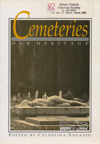
Book, Celestina Sagazio, Cemeteries : our heritage / edited by Celestina Sagazio, 1992
History of Victorian cemeteries; includes a chapter on Aboriginal mission cemeteries; guide to how to use cemeteries for research and family history and how to conserve cemeteries.Paperback; 184 p. : ill., 1 map ; 24 cm.ISBN 0909710856social customs, cemeteries, healesville, victoria, aborigines, st helena, greensborough -
Marysville & District Historical Society
Document (item) - Report, Clement Wilks, Track to the River Jordan Gold Fields, 1864-1865
A report by Mr Road Engineer Wilks on the construction of the Yarra Track in Victoria.A report by Mr Road Engineer Wilks on the construction of the Yarra Track in Victoria. The Yarra Track is the former name of the gold fields road from Healesville to the Woods Point and Jordan Goldfields, in Victoria, Australia. By Authority: JOHN FERRES, Government Printer, Melbourneclement wilks, yarra track, marysville, victoria, wood's point, healesville, jordan gold fields -
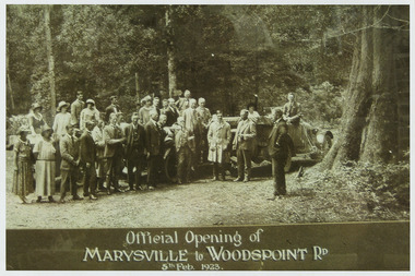 Marysville & District Historical Society
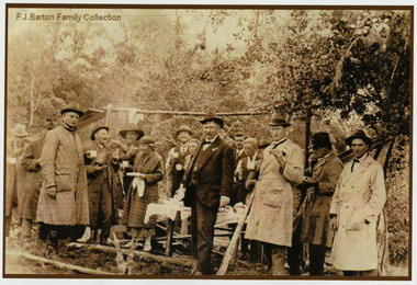
Photograph (Item) - Black and white photograph, Official Opening of MARYSVILLE to WOODSPOINT RD 5th Feb, 1923, 05-02-1924
An early black and white photograph which was taken after the ceremonial re-opening of the Marysville-Wood's Point Road in 1924. The date of 1923 on the photograph is incorrect.An early black and white photograph which was taken after the ceremonial re-opening of the Marysville-Wood's Point Road in 1924. The date of 1923 on the photograph is incorrect. The Marysville-Woods Point Road was originally part of the Yarra Track, constructed in the early 1860s to provide access between Healesville and the Woods Point Goldfields. Despite the steep terrain and engineering difficulties, the Yarra Track soon became a busy route used by pack horses, horse-drawn drays, and wagons. Today this sealed mountain road is a popular scenic drive between Marysville and Warburton.Official Opening of/ MARYSVILLE to WOODSPOINT RD/ 5th Feb, 1923marysville-wood's point road, marysville, wood's point goldfields, healesville, yarra track, warburton, the argus -
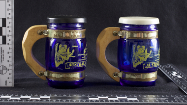 Melbourne Water
Souvenir Salt and Pepper Shakers, 1970s
The Maroondah System was first and foremost developed as a functional component of Melbourne's Water Supply System. In addition to functionality, the Melbourne and Metropolitan Board of Works (MMBW) envisioned the Maroondah Reserve to be enjoyed aesthetically and recreationally by the public. This souvenir illustrates the realisation of the Maroondah System as a local recreational and tourist attraction in the early 20th century. The Maroondah Reserve gardens were landscaped with English-style ornamental stonework, exotic trees, flower beds and rose gardens. All features of the water supply system became widely celebrated as beauty spots that continue to be very popular to this day with tourists and locals alike. This souvenir is a product of that flourishing tourist trade. These water supply sites continue to enhance Melbourne’s charm and liveability and are now recognised as places of cultural and historic significance.These souvenir salt and pepper shakers have been curated by Melbourne Water as they represent an important historical aspect of the organisation by demonstrating the popularity of its water asset sites as recreational places and tourist attractions, and although these sites are functional parts of the water supply system, they were also designed to be enjoyed by the public both aesthetically and recreationally. Additionally, the salt and pepper shakers are aesthetically pleasing as the blue glass and wooden handles demonstrate the design and style of the 1970s. These souvenir salt and pepper shakers feature glass bodies, wooden handles and plastic lids. The salt and pepper shakers are decorated with pictures of koalas, kangaroos and a map of Australia. The text “Maroondah Dam, Vic” has been inscribed on the wooden handles.melbourne metropolitan board of works, mmbw, maroondah, salt and pepper shakers, souvenir, glass, healesville -
 Victorian Aboriginal Corporation for Languages
Book, Nigel Sinnott, Place-names of the Alexandra, Lake Eildon and Big River area of Victoria, 2003
Contains 2000 entries for the Alexandra area, giving a clearly detailed description of the site and source of the name.Maps, colour photographsplace names, alexandra, lake eildon, strathbogie ranges, yea, marysville, healesville