Showing 845 items
matching land subdivisions
-
 Glen Eira Historical Society
Book - O’Neill College, Nagle Avenue, 2, Elsternwick
... Land subdivision... Land subdivision Richard O'Neill Ecclesiastical College ...A commemorative history O’Neill College 1908 – 1981 published at the time of the amalgamation of O’Neill College with star of the Sea, 1982 (2 copies). The book (64 pages) includes a short history of O’Neill college, reports from Monsignor Lyons, Principles report and reports from various other sisters from 1930’s, 40’s, 50’s, 60’s and 70’s. Reminiscences from students activities in the 80’s. Many school photographs of staff, class photos, school outings, sporting events and year 9 camp. Date and author unknown.o’ neill college, sister margaret canoll, presentation secondary, nagle avenue, sister mary kavanagh, education committee, sister christine walsh, elsternwick, sister francis muirhead, peart leanne, sister marie therese harold, star of the sea college, collina filomena, gammaldi tony, mcwilliam lorraine, o'neill college mothers auxillary, mcwilliam barry, st. jospeh's school, sister mary claver stone, sister mary de sales mckenna, sister angela johnston, sister bonaventure harrington, cooper sheila, cooper robert, harnett eileen, harnett desmond, beldart dorothy, catholic schools, primary schools, secondary schools, land subdivision, richard o'neill ecclesiastical college, romanesque style, schreiber r.a., architects, diocesan teacher training college, registers, lists, diaries and journals, halls, kindergartens, school concerts, basketball, choirs, festivals and celebrations, fundraising events, sport, harrison bessie, lynch eileen, murray veronica, mullamby kathleen, mullamby mary, mullamby eileen, miller joseph, strachan barry, webster mary, waldam geoffrey, checchi norman, delaney ella, hooper george, cahill john, cooper john, doyle albert, sister catherine walsh, carr archbishop, mother mary peter fitzgerald, couch mary, couch ambrose, checchi thomas, cahill francis, cooper robert, cooper sheila, castieau margot, castieau john, collinson eileen, collinson john, carolan veronica, carolan james, coates emily, coates henry, cato helena, cato herbert, cato yootha, cahill vincent, cleverley ernest, cleverley francis, cleverley maisie, collins dorothy, collins alfred, clark madge, clark william, gough father, ryan father, morris father, sister benedicta, sister anglea, brennan father, o'neill sarah, riddell parade, mother peter fitzgerald, mother mary bernard justice, sister marie bernade, sister kath coury, hoy hubert mrs, dowling mr, dowling mrs, mclaughlin mr, mclaughlin mrs, collis-brown mr, collis-brown mrs, keane tom, smith coral-anne, dwyer coral, lyons monsignor, miller collin henry, sister catherine curtin, sister peter, sister laserian, sister clare, sister fintan, sister cyril, domec-carre inez, murphy eileen, miller joy, guiney leo, tennis, wood joyce, toomey marie, hayes teresa, sister mary chanel, cobern wanda, sister mary gabriel, jeffrey lorna, sister mary genevieve, pitt jean, clark veronica, phipps sheila, sister sheila, youngberry kathleen, sister benedict, lowday dulcie, sister anne-marie, keary brenda, briglia rita, sister immaculata, burns n., brennan b., wright s., baker e., brdawshaw billy, barnes joan, mason patricia, roberts connie, shelton june, murray betty, keane peggy, taylor audrey, feiss margaret, hoy rosemary, sans lydia, smythe victor, hoy agatha, souter bobbie, brennan kathleen, shelton moira, wallman vera, cox s., rogers s., brennan b., wright s., mckeeran k., power e., maloney j., fyfe p., wright e., chambers f., baker e., keary d., lynch maeve, mcilroy j., corrigan p., harris p., gill p., keogh k., hennessy d., garrett j., feiss j., deverall j., langley j., griffin moya, ashton norma, hull fay, linehan mary, murphy eileen, odgers shirley, brennan jean, mahony denise, meyer margaret, mornament ina, cox s., wright s., borelli marie, flanagan c., smythe p., whelan mary, hawkridge v., johnson v., filippina contessa, rawlings a.b., beer letty, sister mary joseph, eisma joan, langley joan, sister raymond, sister aloysius, garrett betty, sister gertrude, sister elizabeth, sister mary hilary, sister marie louis, stratford c., sister james cantwell, dance mrs., mcnamara colleen, share kath, sister adrian, sister patricia carroll, sister rose, sister pius, dunne patricia, sister james, sister sheila, sister jude, dawes pat, sister beatrice, mason june-maree, sister domenica, guatta win, sister marie cline, sister marie de lourdes, hale mrs, sister robert, sister merle, sister philomena, sister francis xavier, sister frances borgia, sister margaret bullock, sister bruna, mother peter, sister genevieve, kendall vern, collette leonie, sister philomena consedine, ashton francine, maher frank, mcgrath brian, van heeswick julie, west liz, ferrier fran, molloy miss, cooney jenny, tkalcevic josephine, sirianni lena, danielis simonetta, simmonds louis, richardson sharon, giannelli irene, carter louise, ettia gie, williamson helene, galli mrs, meagher mrs, fitzgibbon mrs, beveridge cathy, cocciardi bernadette, emmett mr, emmett mrs, brother moore, farrow sandra, warren angela, peters kim, tarcasio rina, tuohy helen, massey jayne, o'sullivan kerrie, killingsworth miss, conheady mrs, gray mrs, clark fiona, ferrier margaret, dotter andrea, muller mary, young samantha, aquilina tania, baker patricia, bean dianne, bouchereau brenda, brohier audrey, curtis debbie, ferrier frances, hynes nerida, jones leanne, krelle brenda, lamanna ann, loiacono chris, morin jackie, musster judy, renshaw susan, stratford margaret, hoareau marlene, clark nicole, o'neill college, williamson helen, victorian congregation of presentation sisters, sister margaret walsh, archbishop carr -
Glen Eira Historical Society
Document - Hawthorn Road, 284, Caulfield
... Land Subdivision.... Marriot Murray S. Land Sales Land Subdivision Migrants Houses Tram ...Report dated 02/05/1988 about 284 Hawthorn Road, Caulfield by the Brighton Historical Society. It provides a history of this site from 1852 to 1974 including tenants and owners from 1923 to 1974. Handwritten working notes are included.hawthorn road, caulfield, mill road, maxwell nellie, glen john, stevens gar, watson george v.e., niblett thomas a., johnson stanley, williams millie, crawford walter h., usher gordon r., paton m.h. mrs., marriot, murray s., land sales, land subdivision, migrants, houses, tram services, bullock h. miss, landells r. miss -
Glen Eira Historical Society
Article - Hawthorn Road, 449, Caulfield South
... Land Subdivision... Hawthorn Road Caulfield South Land Subdivision Shops Flats ...One item on this address. An article and ads in PRW of 29/07/2011 about three new developments in Caulfield South. Included is a short history and description of the suburb. The projects are all on Hawthorn Road or Maple Street- Maple on the Park - a mixed use of developments Elle-luxury apartments Central Shule Chabad – new synagogue and community centrehawthorn road, caulfield south, land subdivision, shops, flats, caulfield primary school, towers, japanese school of melbourne, sporting clubs, mccubbin frederick, armadale bowls club, brighton cemetery, boyd arthur merricks, artists, bent sir thomas, premiers, bentleigh, bent street, jewish community, maple on the park, cbg architects, maple apartments, schacter max, property developers, century 21 wilson pride, real estate agents, elle, besser david, rosenwald yoel, amira gaby, harper terry, central shule chabad, synagogues, community centres, halls, beter-zionist youth movement, residential development, commercial development, eckstein joey, fein peter, liebowitz lionel, besser dion, butt rochelle -
Glen Eira Historical Society
Document - Lempriere Avenue, 10, St. Kilda East
... . Kilda East, built on a subdivision of the land of William George... Lempriere Avenue, St. Kilda East, built on a subdivision of the land ...A brief history of the property at 10 Lempriere Avenue, St. Kilda East, built on a subdivision of the land of William George Lempriere. Includes some information on the Lempriere Family and public park, Greenmeadows Gardens. The document by Rosalind Landells, David Bick and Hilary Bullock of the Brighton Historical Society is dated October 30, 1995. Includes handwritten notes covering mostly same information. Includes bibliography.greenmeadows, lempriere william george, clarke william senior, lempriere john thomson, zimmerman a.k., nelson frank l., greenmeadows gardens, lempriere avenue, nelson m.d., st. kilda east, parks and reserves, zucker a.a., greenmeadows lane, lempriere family, lempriere’s paddock, councillors -
Glen Eira Historical Society
Article - Rosemont, Kooyong Road, 112A, Caulfield North
... Land Subdivision... William Sir Hall Lady Land Subdivision Cellars Embossed Leather ...Eight items about this property: Handwritten notes from 1870 Caulfield rate book along with list of owners 1870-1890; unsigned and undated. Short history of Rosemont from 1860’s with owners listed up to 1895. Includes description of land and architectural features of house with sketch of pillar. Unsigned and undated with both typed and handwritten information. Unsigned and undated note (original and photocopy) about 112 Kooyong Road and Rosemont’s changing address over time. Photocopy of Andrew Ward’s Heritage Study (two pages) on 112 Kooyong Road (rear) describing significance, history and description of property. Includes photo. Online print without photo of same Heritage Study with handwritten note about brick exterior provided by owner/occupier to compiler Andrew Frederick 2010. Excerpt from Caulfield’s Building Heritage p.47-48 Volume 1 by Dr. Geulah Solomon about Rosemont giving description and history (start of entry on page 46 omitted). Added by Claire Barton date unknown. Notes taken by Andrew Frederick from Caulfield Heritage Vol.1 pages 47-9 re history; and from Sands and McDougall Directories of 1874, 1903, 1911, 1913 and 1923; plus 1913 entry in Vict. P.O Directory. These show house numbers and owners for those periods. Three pages of plans relating to Rosemont covering ground and first floors.rosemont, caulfield north, howitt godfrey dr., kooyong road, blake arthur, grice james, cast iron work, cellars, campbell john a., campbell john archibald, stables, verandahs, king thomas, howitt’s corner, howitt alfred william, farm houses, bakewell john, architectural features, bricks, mcwilliams robert, rosemont estate, mansions, howitt william godfrey dr., arches, balaclava road, coach houses, outbuildings, timber houses, squatters, campbell john, connelly mrs., king florence, slate tiles, ward andrew, chimneys, fireplaces, allen george, warburton james, mirfield professor, hall william sir, hall lady, land subdivision, cellars, embossed leather features, bay windows, house names, victorian style, ceilings, stairs, gardens -
Glen Eira Historical Society
Document - Orrong Road, 56, Elsternwick
... Land Subdivision... Orrong Road Land Subdivision GardenVale Estate Paterson John ...Caulfield Conservation Study on 56 Orrong Road, Elsternwick dated October 1994 and produced by Andrew Ward. Includes a brief architectural description and history of ownership.caulfield conservation study, federation style, architectural styles, architectural features, rowan andrew, elsternwick, orrong road, land subdivision, gardenvale estate, paterson john, paterson catherine, paterson amy, mclaughlin albert, ward andrew, gables, verandahs, tiles, land values -
Glen Eira Historical Society
Article - Seymour Road, 10, Elsternwick, 'Fingall'
... Land subdivision... 'Fingall' House names Land subdivision Caulfield Beemery Park ...Three copies of history and one handwritten document of working notes on 'Fingall', 10 Seymour Road Elsternwick with a brief history of subdivision of Beemery Park. Document lists owners/tenants from 1889 to 1974. History prepared by Brighton Historical Society dated 06/12/1989.seymour road, elsternwick, 'fingall', house names, land subdivision, caulfield, beemery park estate, tibbits william, north william, heron john, raitt charles h, rowland newbury, henry robert, roberts george, fisher william j, hatt ada mrs, o'connor owen e, howard a, howard h, shizas p -
Glen Eira Historical Society
Plan - Ristori
... Land Subdivision... Road Brick Houses Land Subdivision Orrong Road Glasshouses Yeo ...Real Estate leaflet for the subdivision sale of the Ristori Estate & Residence on 31/05/1919 by Yeo, Crosthwaite & Co. A map of the 24 subdivisions available plus a locality plan are included along with details of separate sale on 04/06/1919 of the weatherboard buildings, rooms, stables & glass house.house names, 'ristori', land sales, sewerage, glen eira road, brick houses, land subdivision, orrong road, glasshouses, yeo crosthwaite & co melbourne, ripponlea, stables, ristori estate, auctions, drainage, liscard street, st. georges road, balaclava road, glen huntly road, glenhuntly road, elsternwick station, hotham street, weatherboard buildings, elsternwick -
Glen Eira Historical Society
Article - Rockbrook Road, 16, St Kilda East
... Land subdivision... Land subdivision House names Article Rockbrook Road, 16, St ...Two items about this property and environs: 1/Photocopy of a typed document, dated 29/02/1988, written by Hilary Bullock and Rosalind Landells of Brighton Historical Society, detailing the history and owners and occupiers of 16 Rockbrook Road, St Kilda East. Accompaying it is a handwritten working note of same with the information coming from 'Sand Swamp and Heath'. 2/A Wikipedia article with Bibliography of James Service, joint owner of Rock Brook, St Kilda East (article last modified 01/10/2009).rockbrook road, 'rock brook', gardiner william, st kilda east, the argus, stevenson william, hotham street, caulfield, taylor percy w., balaclava road, service street, brosnan john c., glen eira road, service james, brosnan l.c. mrs., brosnan m miss, vafeas g., bullock hilary, landells rosalind., industrial workers, merchants, commerce, sports and recreations, journalists, newspapers, roads and streets, houses, premiers, parliamentary representatives, land subdivision, house names -
Glen Eira Historical Society
Letter - RIDDELL PARADE, 78, ELSTERNWICK
... Land Subdivision... Riddell Parade Orrong Road Cottages Land Subdivision Coolarra ...Two items about this property: 1/Contains a report for A J Barley Pty Ltd (Real Estate Agent) by Hilary Bullock and Rosalind Landells of Brighton Historical Society on the property at 78 Riddell Parade Coolara from November 15 1985. Includes a brief history of the area, a list of owners/residents and some information on architectural details of the house. Also contains a letter of apology and explanation dated 30 November 1985 from Mrs Landells over an error of interpretation which led to a mistake in the report. 2/Auction flyer, date unknown (but likely circa November 1985), for Bay View Villa for rela estate agent A J Barley.walker mary, riddell john carre, cavers carre, ross william murray, elsternwick, carnegie, rosstown, railway lines, rosstown junction railway, jefferson m g b, ward cole george, cole george ward, williams fred, hughes horace c, railway crescent, riddell parade, orrong road, cottages, land subdivision, coolarra, bayview villa, bay view villa, plaster moujlds, fireplaces, a. j. barley pty ltd, estate agents, o'brien dorothy, victorian style, 'cavers carre', house names -
Glen Eira Historical Society
Document - St. Georges Road, 10, Elsternwick
... Land Subdivision... Elsternwick Railway Station Bullock H. Landells R. Land Subdivision ...A typed research report dated to 25/11/1987 by H. Bullock and R. Landells discussing the history of the ownership and occupancy of Kent at 10 St. Georges Road, Elsternwick and briefly the history of the street’s subdivision.kent, st. georges road, elsternwick, davis p., duffy road, george street, copland oeric rev., eberach louis, lynch james, white charles j., white a. a. miss, smith h. w., sherlock j. mrs, sharp frederick j., ripponlea, elsternwick railway station, bullock h., landells r., land subdivision, victorian style, house names -
 Glen Eira Historical Society
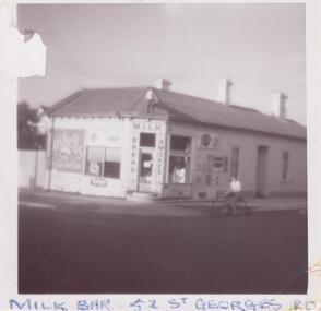
Photograph - ST. GEORGES ROAD, 52, ELSTERNWICK
... Land Subdivision... Photographs Elsternwick Land Subdivision Federation Style ...Four items about this property: 1/Two typed research reports, dated 10/07/1987 and 12/03/1995, by Hilary Bullock and Rosalind Landells, regarding the history of ownership and occupancy of 52 St. Georges Road, Elsternwick and a description of the development of the building. Includes handwritten working notes, undated, for the 12/03/1995 report. 2/Handwritten file note from Sands and McDougalls from 1903 to 1948, giving occupiers' names and occupations. 3/A black and white photograph of the building as a milkbar plus a colour photograph dated 1982 of the milkbar. 4/Three photos and brief notes for auction of property in 2006 by Hocking Stuart. Dates for these advertisements are 08/11/2006 for one and 10/11/2006 for the other two.st. georges road, photographs, elsternwick, land subdivision, federation style, architectural styles, corner stores, drew alexander, shops, tennis courts, drew a., general stores, righetti mrs, grocers, righetti n, businesses, hodges edward, milkbars, flats, woodrow r miss, houses, geddings p., geddings w., business people, ogden s., brighton historical society, ogden a, landells rosalind, bright j.a., dowsing i, batagnol i., arnold h.t., batarol l., noel jones real estate agency, turner r., rand real estate pty ltd, nemeth f., noel jones real estate agency, serginis c., sergianis c., bullock hilary, timber houses, greengrocers, victorian style, stained glass -
Glen Eira Historical Society
Document - Swibiton, Gladstone Parade, 28, Elsternwick
... Land Subdivision.... Kooyong Park Estate Land Subdivision Victorian Style Gladstone ...Caulfield Conservation Study by Andrew Ward dated October 1994 on Swibiton, 28 Gladstone Parade Elsternwick. Detailed description of house exterior and brief history of owners and, or, tenants who lived there from 1889 to 1941.gladstone parade, swibiton, elsternwick, architectural features, kirkham emma, pye w., kooyong park estate, land subdivision, victorian style, gladstone road, carlingford street, ward andrew, clarence street, eagerty edward, allen samuel, white william, byham j.m., mcdougall chas. -
 Glen Eira Historical Society
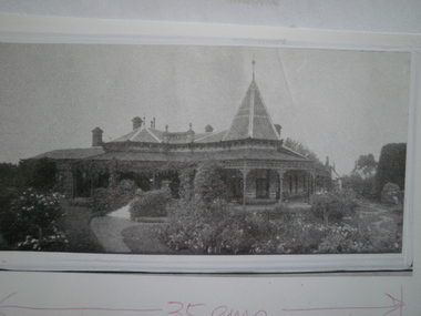
Photograph - Urandaline, Glen Eira Road, 434, Caulfield
... Land Subdivision... Road Land Subdivision Mansions Photograph Urandaline, Glen Eira ...Photographs of Urandaline, with two photocopies, taken in 1926 showing the garden.urandaline, glen eira road, land subdivision, mansions -
Glen Eira Historical Society
Document - Urandaline Estate
... Land Subdivision... Road Land Subdivision Caulfield Hawthorn Road Caulfield Railway ...Two items about the acution of Urandaline Estate 1) 2 reduced copies of auction notices for Urandaline Estate, February 05, 1927 2) 3 photocopied auction brochures, one including a plan of subdivided blocks for sale of Urandaline Estate, and another including terms of sale for properties by Arthur Tuckett and sons and H.L.W. Cade Estate Agent.urandaline estate, glen eira road, land subdivision, caulfield, hawthorn road, caulfield railway station, urandaline, arthur tuckett and son, johnson johnson and davies, urandaline grove, solicitors, estate agents, cade h.l.w., auctioneers mackay g.j., bambra road, kambrook road, mansions -
Glen Eira Historical Society
Document - Wheatley Road, 143, Ormond
... Land Subdivision... Wheatley Road. Document is undated and unsigned. Land Subdivision ...Handwritten document regarding Alexander E. Wheatley. List of owners from 1892 to 1990 who lived at 143 Wheatley Road. Document is undated and unsigned.land subdivision, wheatley alfred e., wheatley road, ormond, wheatley alexander e., brighton estate, north road, malva street, ruby street, maud street, barrett edward e., mcdonald john, ryan m.a. mrs, mellor william, burman ernest, mann harry, mann jean mrs., mann k. miss., mann j. miss., mann c.h. miss., palfrey r.m., barrett edward -
Glen Eira Historical Society
Document - Orrong Estate
... Subdivision Land titles Auctions Auctioneers Buildings by condition ...Photocopy of the contract and conditions of sale of Orrong Estate to Ernest Melbourne Boyle, dated 12/01/1916. Includes a hand drawn plan of the area. Photocopied receipt for payment by Ernest Melbourne Boyle, dated 13/01/1916.orrong estate, orrong road, inkerman road, caulfield, labassa grove, pearson grove, sydney arnold best and co, yeo crosthwaite and co, east st kilda sand proprietary limited, east saint kilda sand proprietary limited, seton williams and heathfield, estate agents, legal documents, receipts, real estate agents, financial documents, lawyers, subdivision, land titles, auctions, auctioneers, buildings by condition, land sales, land values, boyle ernest melbourne -
 Glen Eira Historical Society
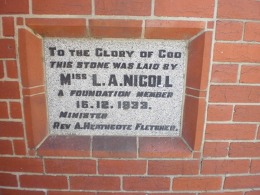
Article - St. Andrew’s Presbyterian Church, North Road, Gardenvale East
... to Glen Eira News and City Council re-proposed subdivision... of letter to Glen Eira News and City Council re-proposed subdivision ...Handwritten document giving brief details on wording on foundation stone of St. Andrew’s church, undated and author unknown. Photocopy of pamphlet produced for the stewardship campaign 1957 for St. Andrew’s Presbyterian Church Gardenvale East, with several photos. It includes history as well as current situation at 1957. Photocopied notes and photo of the Army Hut used by Gardenvale Primary School in 1921 only as donated by church for and year then Reverted back to church use. Photocopy of letter to Glen Eira News and City Council re-proposed subdivision of church land from Robert W. Sinclair.st. andrew’s presbyterian church, foundation stones, nicoll l.a., heathcote-fletcher a. rev., north road, seach street, smith a. f.h. rev., mcneilage alex rev., gardenvale east, caulfield south, younger street, gardenvale east church, nicholls rev., rowlands w. rev., lang walter, sunday schools, yeaman f.e. rev., brown f.e., brick, towers, manse, choirs, groups, smith mrs., curtis e.e., morse roger, marryatt harry, pegler adrian, savill t., south caulfield, gardenvale primary school, sinclair robert w., dakin ms., campbell felicity -
Glen Eira Historical Society
Document - St. James The Great, Inkerman Street, 435, St Kilda East
... Land Subdivision... E.D. Laurey Robert Building Land Subdivision Minsters Market ...Handwritten notes made by Claire Barton 17/07/2012 from the St. James Community website. Includes information on the history and architectural features of the Church. Also included are comments on its relationship to the St. John’s Seminary. Correspondence to Claire Barton from parishioner Helen Fraser dated 07/05/2012.st. james the great, inkerman street, st. kilda east, north and williams, architects, st. john’s college, religious structures and establishments, alma road, lansdown road, alexander street, anglican church, stephens r. rev., fordham e.d., laurey robert, building, land subdivision, minsters, market gardens, vicarages, tennis courts, tennis, service stations, kelly roger fr., porter brian rev. dr., fraser helen -
Glen Eira Historical Society
Document - Helenslea, Shelford CEGGS
... Land subdivision... to 1889. Hood Judge Stephen George Sir Helenslea Land subdivision ...One page of undated and unattributed handwritten notes regarding the grant of Helenslea land to Sir George Stephen and providing assessment numbers and information on the number of rooms and occupants of Helenslea for the period 1860 to 1889.hood judge, stephen george sir, helenslea, land subdivision, caulfield north, hood crescent -
Glen Eira Historical Society
Document - Helenslea, Shelford CEGGS
... Land subdivision... St Mary’s Church Caulfield North Land subdivision Land ...Three copies of a photocopied fold out brochure for the auction of Helenslea mansion and stables on 25/03/1916 in association with the sale of the adjoining allotments of the Helenslea Estate. The brochure includes a map of the Helenslea Estate, a photograph of the view from Helenslea Mansion, an illustration of the exterior of the Mansion and a detailed floor plan of the Mansion and stables.helenslea mansion, helenslea estate plan, glen eira road, hood crescent, merton street, stables, hawthorn road, orrong road, morrice street, helenslea road, st kilda east, auctions, st mary’s church, caulfield north, land subdivision, land brochures, residential development -
Glen Eira Historical Society
Document - Helenslea, Shelford CEGGS
... Land subdivision... Church Land subdivision Land brochures Residential development ...Three copies of a photocopied fold out brochure relating to the auction of 48 lots in the Helenslea Estate on 25/03/1916. The brochure references St Mary’s Church, shops on Glen Eira Road, Caulfield Grammar School, and existing homes in the vicinity and includes photographs of these localities. Reference is also made to available public transport and trees on the Estate. The brochure also includes an illustrated bird’s eye map of the Estate.helenslea estate, glen eira road, st kilda east, mansions, orrong road, balaclava road, caulfield grammar school, fosberry avenue, st mary’s church, land subdivision, land brochures, residential development, auctions, caulfield north -
Glen Eira Historical Society
Document - KAMBROOK ROAD, 46, CAULFIELD NORTH
... Land subdivision... Road Land subdivision Document KAMBROOK ROAD, 46, CAULFIELD ...A copy of a one page typed report by Hilary Bullock and Rosalind Landells of the Brighton Historical Society, dated 14/10/1995, with handwritten notes about this property. It covers the owners of this address from 1918 to 1994 and a short history of the origins of Caulfield Racecourse and land development by 1917. It also mentions the first meeting of the Caulfield Amateur Turf Club in 1859.caulfield north, kambrook road, caulfield cup, caulfield racecourse, racecourses, caulfield amateur turf club, 'kambrook', payne john, balaclava road, swan william h, urquhard john, wenn john, reddon george, may phillip g, griffin g mrs, newton g t (horse trainer), bullock hilary, landells rosalind, bick david, foote henry (surveyor), caulfield roads board, glen eira road, land subdivision -
Glen Eira Historical Society
Document - Kooyong Road, 110, Caulfield North
... Land subdivision... Hilary Landells Rosalind Land subdivision Document Kooyong Road ...Copy of typed letter 27/05/1989 from Brighton Historical Society giving details of history/owners/tenants of 110 Kooyong Road, Caulfield North from 1840 to 1985. Accompanied by handwritten working notes naming owners/tenants of property 110 Kooyong Road, North Caulfield from 1936 to 1985. House was built in 1936.kooyong road, rosemont farm, howitt godfrey dr, settlers, caulfield north, howitt alfred, henderson garnet w., henderson m.m. miss, haskin joseph, anstee w.e., holst edward, bullock hilary, landells rosalind, land subdivision -
Glen Eira Historical Society
Document - Denver Crescent, 18, Elsternwick, 'Wendouree'
... Land subdivision... Society Houses Land subdivision Wendouree Document Denver Crescent ...A copy of a typed report dated 25/2/1989 concerning 18 Denver Crescent, Elsternwick by H Bullock and Rosalind Landells. The report contains a description of the location and of the residents of the house. An undated unattributed handwritten draft of part of the report is also included.dixon edward r, morrell george h, stocker hw, bullock h, rosalind landells, denver crescent, elsternwick, o’neill henry, o’neill college estate, brighton historical society, houses, land subdivision, wendouree -
Glen Eira Historical Society
Article - Long Street, 10, Elsternwick
... Land subdivision... Land subdivision Munro John P Reynolds I A Miss Bainbridge F F ...Two items about this property: A type written letter dated 03/11/1988 from Rosalind Landells and Hilary Bullock regarding the history of the occupants of 10 Long Street Elsternwick from 1889-1974. Included is a handwritten page of working notes, undated and unattributed listing the occupant history. An advertisement unsourced, dated 26/5/2006 for the forthcoming auction of 10 Long Street. The advertisement describes key architectural and other features of the house and includes a copy of a colour photograph.elsternwick, long street, advertisements, victorian style, land sales, architectural features, auctions, depression 1890s, land subdivision, munro john p, reynolds i a miss, bainbridge f f, ebbs william h, hunt harry, turner m c miss, hobbs cecil h, mcgillivray e mrs, bowles james, place thomas e, murray herbert, mcbride george, homeman george e, answerth l. m mrs, newling arthur, swann herbert c, matheson alfred, hannett r e, sullivan j, bullock hillary, landells rosalind -
Glen Eira Historical Society
Poster - Eddy's Grove, 29, Bentleigh
... Land Subdivision..., Bentleigh Eddy’s Grove Centre Road Bentleigh Land Subdivision W.H ...An undated typed poster for the forthcoming auction on April 18, 1936 of the brick house at 29 Eddy’s Grove, Bentleigheddy’s grove, centre road, bentleigh, land subdivision, w.h. wood and co. -
Glen Eira Historical Society
Letter - Luton, Victoria Street, 4, Elsternwick
... Land Subdivision... and Reserves Property Developers Land Subdivision Edwardian Style ...Copies of the correspondence between Louise Tappin and Mrs Wallace Landells dated 17/10/1987 regarding information requested about the Edwardian Style house Luton, Victoria St. Elsternwick. Two documents one handwritten copies of the third, a typed overwritten copy of the original correspondence. One copy is a letter to Ms Tappin while the other correspondence details the history of Luton and its previous owners. The fourth document is a handwritten note of the research undertaken on Luton.luton, hopetoun gardens, landells rosalind, victoria st, victoria gardens, cummins deborah, elsternwick, parish of prahran, bullock hilary, glenhuntly rd, tappin louise, allee john, caulfield north, landells wallace (mrs), gourlay j, duncombe edward .t., duncombe eleanor a., carson william s., sarah c.r., noel jones real estate, masseurs, real estate agents, real estate agencies, parks and reserves, property developers, land subdivision, edwardian style, architectural styles houses -
Glen Eira Historical Society
Plan - Nettalie
... Land subdivision... Grammar School Land subdivision Land sales Land titles Legal ...Land Victoria title documents vol 339 folio 763A and 764 relating to the property Nettalie on the corner of Balaclava and Orrong Rds. These documents detail the history of the land dealing relating to Nettalie and the neighbouring estate Harleston listed as parcels 209a and 209b. These dealing include grants of land, mortgages and conveyance (transfers). The documents include photocopies of handwritten notes of the title history date 1870; a partial copy of an instrument of conveyance dated 1863 and the original titles of the land owned at various times by William Noall, Alfred Shaw, Alfred Desailly and Sir Frederick Grimwade. Within the documents are various hand drawn and printed diagrams of the subdivisions.forsyth william, noall william, cutts william henry, shaw alfred, hailes george button, bakewell john, pascoe john randle, little william, fraser alexander, powell walter, whitney john, hodgeson richard, trollope william thomas, keep edward, blundell mary, carr john bonney, farie claud, fosberry john wallcott, davies john, brady michael, lloyd frederick, turner george, desailly alfred, grimwade frederick s sir, parish of prahran, county of bourke, caulfield north, st kilda east, balaclava road, orrong road, nettalie, netley house, harleston, melbourne grammar school, land subdivision, land sales, land titles, legal documents, homestead, schools, houses -
Glen Eira Historical Society
Document - Orrong Road, 225/225A, St. Kilda East
... Land Subdivision... Rosalind Brighton Historical Society Land Subdivision Spence David ...A history of the creation and ownership of 225/225A Orrong Road Caulfield researched by H. Bullock and Rosalind Landells and dated to 25/07/1988. Includes handwritten notes regarding the same subject.orrong road, st. kilda east, lempriere william george, greenmeadows, clarke william, shire of caulfield, councillors, caulfield city, caulfield, bullock h., landells rosalind, brighton historical society, land subdivision, spence david, david street, flats, cooke jordan, cooke w.