Showing 80974 items
matching lap-of-the-lake
-
 Moorabbin Air Museum
Booklet - THE BATTLE OF BRITAIN AUGUST - OCTOBER 1940, THE MINISTRY OF INFORMATION ON BEHALF OF THE AIR MINISTRY, 1941
... THE BATTLE OF BRITAIN AUGUST - OCTOBER 1940...THE MINISTRY OF INFORMATION ON BEHALF OF THE AIR MINISTRY ... -
 Ringwood and District Historical Society
Photograph, The time capsule of the facsimile of the miner's hut, located at the back of Ringwood Lake, from the original that once stood on Maroondah Highway in the 1870s onwards. The capsule will be reopened on 28 January 2050. The cottage was erected by the Ringwood City Council in conjunction with Ringwood Historical Research Group (now Ringwood & District Historical Society). Officially opened by Mayor Cr Pat Gotlib JP on 29th May 1983
... The time capsule of the facsimile of the miner's hut ...Photographic record by Russ Haines, RDHS, in October 2008. -
Phillip Island and District Historical Society Inc.
Book, Signs of the Times, Home and health : a household manual ; containing two thousand recipes and helpful suggestions on the building and care of the home in harmony with sanitary laws; the preservation of health by clean, consistent living; and the home treatment of the more simple ailments and diseases, by the use of natural, rational remedies instead of drugs / prepared and edited by a competent committee of home-makers and physicians, 1908
... of the home in harmony with sanitary laws; the preservation...Signs of the Times ...Labelled: 'Phillip Island & District Historical Society', 'Presented to the Phillip Island & District Historical Society by Mrs Sybil Justice of Ventnor. 1969.' Inscribed 'Mrs T. Justice, Grantville, 10/3/09'.home & health, t justice -
 Ringwood and District Historical Society
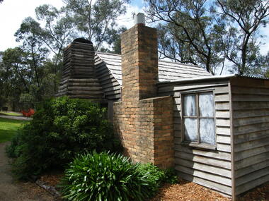
Photograph, Showing the exterior views of the facsimile of the miner's hut, located at the back of Ringwood Lake, from the original that once stood on Maroondah Highway in the 1870s onwards. The cottage was erected by the Ringwood City Council in conjunction with Ringwood Historical Research Group (now Ringwood & District Historical Society). Officially opened by Mayor Cr Pat Gotlib JP on 29th May 1983
... Showing the exterior views of the facsimile of the miner's ...Photographic record by Russ Haines, RDHS, in October 2008. -
 Ringwood and District Historical Society
Photograph, Showing the interior views of the facsimile of the miner's hut, located at the back of Ringwood Lake, from the original that once stood on Maroondah Highway in the 1870s onwards. The cottage was erected by the Ringwood City Council in conjunction with Ringwood Historical Research Group (now Ringwood & District Historical Society). Officially opened by Mayor Cr Pat Gotlib JP on 29th May 1983
... Showing the interior views of the facsimile of the miner's ...Photographic record by Russ Haines, RDHS, in October 2008. -
 Ringwood and District Historical Society
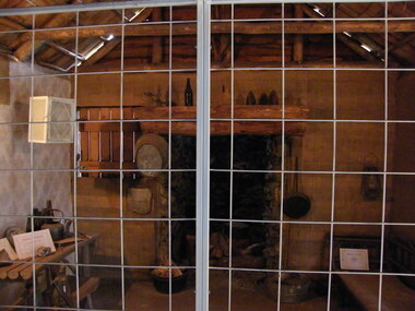
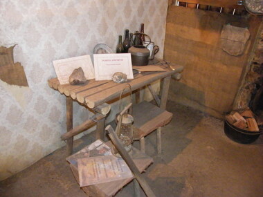
Photograph, Showing the tools and equipment rooms of the facsimile of the miner's hut, located at the back of Ringwood Lake, from the original that once stood on Maroondah Highway in the 1870s onwards. The cottage was erected by the Ringwood City Council in conjunction with Ringwood Historical Research Group (now Ringwood & District Historical Society). Officially opened by Mayor Cr Pat Gotlib JP on 29th May 1983
... Showing the tools and equipment rooms of the facsimile of ...Photographic record by Russ Haines, RDHS, in October 2008. -
 Ringwood and District Historical Society
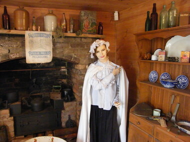
Photograph, Showing the living rooms of the facsimile of the miner's hut, located at the back of Ringwood Lake, from the original that once stood on Maroondah Highway in the 1870s onwards. The cottage was erected by the Ringwood City Council in conjunction with Ringwood Historical Research Group (now Ringwood & District Historical Society). Officially opened by Mayor Cr Pat Gotlib JP on 29th May 1983
... Showing the living rooms of the facsimile of the miner's ...Photographic record by Russ Haines, RDHS, in October 2008. -
 Ringwood and District Historical Society
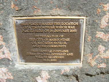
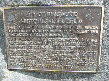
Photograph, The official plaque of the facsimile of the miner's hut, located at the back of Ringwood Lake, from the original that once stood on Maroondah Highway in the 1870s onwards. The cottage was erected by the Ringwood City Council in conjunction with Ringwood Historical Research Group (now Ringwood & District Historical Society). Officially opened by Mayor Cr Pat Gotlib JP on 29th May 1983
... The official plaque of the facsimile of the miner's hut ...Photographic record by Russ Haines, RDHS, in October 2008. -
 Stawell Historical Society Inc
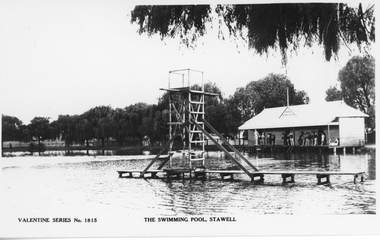
Photograph, Cato Lake diving platform -- Postcard
Diving Tower Valentine Series Card No. 1815. Post card is a view of the diving platform with the change rooms at the lake. On the verandah of the change room are people in swimming costumes and one person about to dive into the lake. There is also an enlarged photo of the post card. c 1930-1940.Valentine Series Post Card No 1815 of the Diving Tower and Change rooms at Lake c 1930 - 1940. The post card is black & white with trees along the lake and behind the change room. Valentine Series No. 1815 THE SWIMMING POOL, STAWELL on the back Published by the Valentine Publishing Co. Pty. Ltd., Queen St., Melb.stawell -
 Flagstaff Hill Maritime Museum and Village
Photograph, Photograph of Lake Pertobe
... Photograph of Lake Pertobe ...Photograph of Lake Pertobeflagstaff hill, warrnambool, shipwrecked-coast, flagstaff-hill, flagstaff-hill-maritime-museum, maritime-museum, shipwreck-coast, flagstaff-hill-maritime-village -
 Ballarat Heritage Services
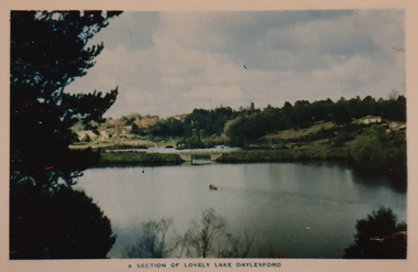
Photograph, Nucolorvue, A Section of Lake Daylesford, 1957
... A Section of Lake Daylesford ...Daylesford is a tourist town in Central Victorian, known for its mineral water springs.A Section of Lake DaylesfordDaylesford, Victoria, Australia This famous holiday resort is famous for its up-to-date facilities, as well as for its natural attractions. The mineral Springs are renowned for their high medicinal elements. The visitor finds ample to amuse, in excellent fishing, boating, Boating, Swimming, golfing, hiking and riding. The district provides a wide range of typical Australian bush scenery, and the altitude of 2,000 feet above sea level as a tonic effect on all. Daylesford has modern hotels, guest houses, shops and places of amusement, also many other places of interest within short travelling distance. Bendigo, 50 miles, Ballara 30 miles, and Melbourne 75 miles, bring Daylesford within easy reach of many parts of Victoria. daylesford, swimming, lake daylesford -
Stawell Historical Society Inc
Map, Agricultural Area of Lake Wilson, Parishes of Bellaura & Bellellen, 1865
... Agricultural Area of Lake Wilson, Parishes of Bellaura ...Agricultural Area of Lake Wilson, Parishes of Bellaura & Bellellenstawell -
 Whitehorse Historical Society Inc.
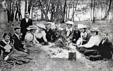
Photograph, Blackburn Lake, 1901
Photocopy of a group, thought to be the Augustine Congregational Church, Auburn, at a picnic at Blackburn Lake in 1901 Inscription. For dear Gert. Eunice AULT, 6th from viewer's right (probably with members of St Augustine Congregational Church, Burwood Road, Hawthorn.Eunice Olive Ault later Mrs Henry E Press. Henry Press was a member (perhaps an office-bearer) of Scots Church, Melbourne and Eunice attended there with him. She lived with him at 8 Dean Ave, Hawthorn and after his death resumed her association with Augustine Church. Blackburn 11 Nov 1901.clothing & dress, blackburn lake -
 Ringwood and District Historical Society
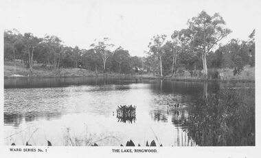
Photograph, The Lake, Ringwood. Ward Series No.1 Postcard (undated)
... The Lake, Ringwood. Ward Series No.1 Postcard (undated) ...1 image with postcard name, 1 with name cropped out.Inscription below photograph reads, "Ward Series No.1. The Lake, Ringwood". -
 Stawell Historical Society Inc
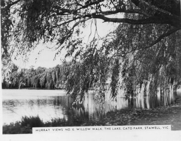
Photograph, Murray Views, "Willow Walk" at the Lake in Cato Park Stawell c1950 -- Postcard, C 1950
... "Willow Walk" at the Lake in Cato Park Stawell c1950... Purchased thes Murray Views Cards. The Cards were produced for sale... Purchased thes Murray Views Cards. The Cards were produced for sale ...Sister of Donor Visited Stawell in th e1950'2 When she Purchased thes Murray Views Cards. The Cards were produced for sale to touristsSet of 8 Murry Views Postcards No 1 to No 8 C. 1950Murray Views No 6 Willow Walk The Lake Cato Park Stawell -
 Latrobe Regional Gallery
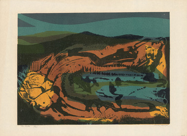
Print, HOS, Kees. Born 1916, The Hague, Holland, The Lake, 1970
... The Lake...HOS, Kees. Born 1916, The Hague, Holland ...Signed lower right under printed image 'Kees Hos '70' Title and edition 1/30 - lower left under image -
 Victorian Railway History Library
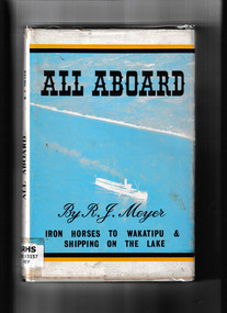
Book, Meyer, R. J, All Aboard - Iron Horses to Wakatipu & Shipping on the Lake, 1963
... All Aboard - Iron Horses to Wakatipu & Shipping on the Lake...The New Zealand Railway and Locomotive Society Inc ...A history of the railways and lake shipping in and around Lake Wakatipu New Zealand.index, ill, maps, p.118.non-fictionA history of the railways and lake shipping in and around Lake Wakatipu New Zealand.railroads -- new zealand -- lake county., shipping -- new zealand -- wakatipu, lake. -
RMIT GSBL Justice Smith Collection
Book, Wiseman, H. Dallas, The law relating to the transfer of land : comprising the Transfer of Land Act 1928 (Victoria) and other acts affecting the transfer of land with commentary, notes of Australasian decisions, forms in general use and rulings and practice of the office of titles, 1931
... The law relating to the transfer of land : comprising the...The Law Book Co. of Australasia Pty Ltd ...Second editionvictoria. transfer of land act 1928, real property -- victoria, transfer (law) -- victoria, land titles -- registration and transfer -- victoria -
 Dutch Australian Heritage Centre Victoria
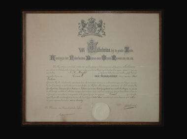
Framed Certificate, 9 May 1924
... Government of the Netherlands...'s-Gravenhage, The Netherlands ...The declaration was noticed in an antique shop by a Dutch antique dealer who purchased it and donated it to the DAHC.Official declaration establishing the Dutch Consulate in Melbourne. The framed declaration is signed by the Dutch Minister of Foreign Affairs and the Dutch Queen, Wilhemina of Orange, on 9 May 1924.Dated: 9 Mei negentien vier en twintig ( 9 May 1924 ) and signed by Queen Wilhelmina. Has creases that somebody tried to fix with white-out. -
Marysville & District Historical Society
Flyer (item) - Information Flyer, Parks Victoria, Yarra Ranges National Park-Lady Talbot Drive, Cambarville and Lake Mountain-Visitor Guide, 01-2018
A flyer that was produced as a guide to Lady Talbot Drive, Cambarville and Lake Mountain.A flyer that was produced as a guide to Lady Talbot Drive, Cambarville and Lake Mountain. Lady Talbot Drive a 24 kilometer scenic rainforest car journey which passes a number of walks and waterfalls in the Yarra Ranges National Park. Lady Talbot Drive is named after Lady Sarah Elizabeth, the wife of Sir Reginald Talbot, who was the Governor of Victoria from 25th April, 1904 to 6th July 1908. Cambarville is notable for its giant mountain ash (Eucalyptus regnans) trees within the Cumberland Memorial Scenic Reserve, and relics from former sawmills and gold mining. The Big Culvert is located nearby on the Marysville-Woods Point Road, which was historically part of the Yarra Track. Cambarville was established as a timber mill town in the 1940s. Timber mill owners A Cameron and FJ Barton named Cambarville. They established the mill to salvage timber from trees destroyed in the 1939 bushfires. Cambarville was impacted by the 2009 Black Saturday bushfires and any remaining structures were destroyed. Lake Mountain is the closest alpine cross-country ski resort to Melbourne.lady talbot drive, lady talbot forest drive, cambarville, lake mountain, sir reginald talbot, lady sarah elizabeth talbot -
 Stawell Historical Society Inc
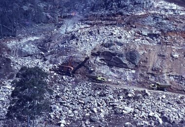
Slide, Ian McCann, Lake Bellfield Under Construction, 1965
Lake Bellfield Under ConstructioColour Slide: Showin tow trucks and a Steam Shovel on th eeastern side of Lake Bellfield. -
 Federation University Historical Collection
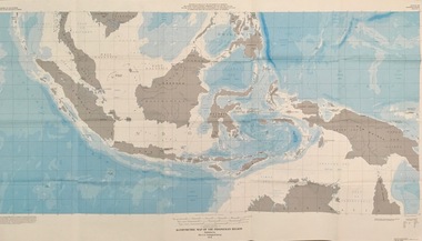
Map - Geological, U.S. Government Printing Office, Bathymetric Map of the Indonesian Region: Folio of the Indonesian Region Map I-875-A, 1974, 1974
... Bathymetric Map of the Indonesian Region: Folio of the...The U.S. Geological Survey...United States of America ...Map was prepared on behalf of the Government of Indonesia, The United Nations Economic Commission for Asia and the Far East, the Agency for International Development and the U.S. Department of State in cooperation with the Geological Survey of Indonesia. The area covered shows the islands and seas from Latitude 12 degree North to 16 degrees South and Longitude 90 degrees to 148 degrees. Various water features are also named.Large map showing the Indonesian area - islands and seasLongitude and Latitude are shown. Major / Capitol cities indicated. Names of those responsible for the productionindonesia, united nations economic commission, department of state, geological survey, latitude, longitude, government of indonesia -
 Stawell Historical Society Inc
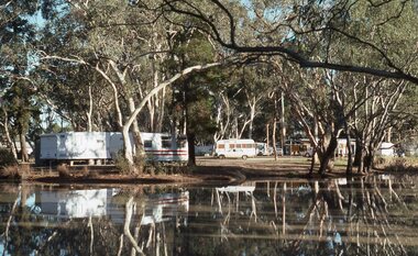
Slide, Ian McCann, View Across the lake at the Caravan Park
... View Across the lake at the Caravan Park ...Caravan Park with vans across the lake at Stawell Caravan Parkbuildings, caravan park -
 Federation University Historical Collection
Photograph - Lake Wendouree, Ballarat School of Mines Boathouse on Lake Wendouree, c1977
... Ballarat School of Mines Boathouse on Lake Wendouree ...A weatherboards Boathouse on Lake Wendoureeballarat school of mines boat house, boat house, lake wendouree, library, reference librarian -
 Ballarat Heritage Services
Photograph, Nucolorvue, A Corner of Jubilee Lake, Daylesford, 1957
... A Corner of Jubilee Lake, Daylesford ...Daylesford is a tourist town in Central Victorian, known for its mineral water springs.Image of Jubilee Lake, Daylesford.Daylesford, Victoria, Australia This famous holiday resort is famous for its up-to-date facilities, as well as for its natural attractions. The mineral Springs are renowned for their high medicinal elements. The visitor finds ample to amuse, in excellent fishing, boating, Boating, Swimming, golfing, hiking and riding. The district provides a wide range of typical Australian bush scenery, and the altitude of 2,000 feet above sea level as a tonic effect on all. Daylesford has modern hotels, guest houses, shops and places of amusement, also many other places of interest within short travelling distance. Bendigo, 50 miles, Ballara 30 miles, and Melbourne 75 miles, bring Daylesford within easy reach of many parts of Victoria. daylesford, jubilee lake, pier -
Stawell Historical Society Inc
Map, Agricultural Area of Lake Wilson, 1865
... Agricultural Area of Lake Wilson ...Agricultural Area of Lake Wilsonstawell -
 Mont De Lancey
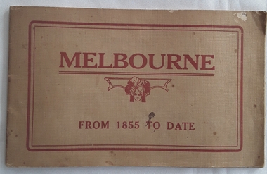
Booklet, Lake and Sons Pty. Ltd, Melbourne from 1855 to Date - Souvenir of Melbourne Old and New, Unknown
... Melbourne from 1855 to Date - Souvenir of Melbourne Old and ...A souvenir booklet of Melbourne Old and New, depicting in black and white photographs and illustrations the life and images of life in the 1800's in this city.Beige small rectangular paperback souvenir book, Melbourne from 1855 to Date. The cover has the title in red lettering with a symbol of a woman's face in the middle. The back has Lake and Sons Pty. Ltd., Printers. 310 King Street, Melbourne. The Introduction gives an overview of what Melbourne looked like in the 1800's. The pictures of early Melbourne reproduced in this Souvenir are from the original collection of J.Feldheim, Esq. It includes black and white photographs and illustrations. 63p.non-fictionA souvenir booklet of Melbourne Old and New, depicting in black and white photographs and illustrations the life and images of life in the 1800's in this city.history - melbourne, melbourne - 1800's -
 Ballarat Heritage Services
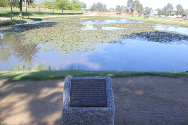
Photograph - Colour, Clare Gervasoni, Lake Penhalluriack in the Eureka Stockade Memorial Garden, 25/10/2018
... Lake Penhalluriack in the Eureka Stockade Memorial Garden ...Colour photographs of Lake Penhalluriack.eureka stockade memorial gardens, eureka stockade, pikeman's dog, sculpture -
Phillip Island and District Historical Society Inc.
Book, De COLANGE, Leo, picturesque world, or, Scenes in many lands, with one thousand illustrations on wood and steel of picturesque views from all parts of the world comprising mountain, lake and river scenery, parks, palaces, cathedrals, churches, castles, abbeys, and other views selected from the most noted and interesting parts of the world ; with original and authentic descriptions by the best authors, 1878-9
... all parts of the world comprising mountain, lake and river ...Labelled 'Cowes Free Public Library', 'Phillip Island Historical Society, Cleeland Bequest'. V.2 inscribed 'Jno. Cleeland, Wollomai' -
Ringwood and District Historical Society
Newsletters, Newton Press, 'The Spirit' Quarterly newsletters: Mar-1985 and Jun-1985. Published by the people of the Holy Spirit Parish, North Ringwood, 1985
... . Published by the people of the Holy Spirit Parish, North Ringwood....The people of the Holy Spirit Parish ...'The Spirit' Quarterly newsletters: Mar-1985 and Jun-1985. Published by the people of the Holy Spirit Parish.