Showing 5976 items
matching later years
-
 Eltham District Historical Society Inc
Photograph, Liz Pidgeon, Heritage Excursion; East of Eltham, 6 Sep 2014, 20 May 2017
... . In later years it has been subdivided for residential purposes.... In later years it has been subdivided for residential purposes ...Newsletter No. 218, September 2014 September Excursion - East of Eltham Walk In Newsletter No. 197, March 2011, there was a brief history of Crown Allotment 15 Section 5 Parish of Nillumbik (CA 15) a parcel of land of a quarter of a square mile extending from Eucalyptus Road to Reynolds Road at the eastern extremity of Eltham. From the 1940s it was known as Stokes orchard. In later years it has been subdivided for residential purposes but leaving significant areas as power line and water supply reserves and bushland reserves that are habitat for the threatened For our excursion on 6th September we intend to walk through CA 15 to a bushland reserve east of Reynolds Road. The walk will traverse the boundary between suburban Eltham and the non-urban areas to the south and east. This is a pleasant walk through residential areas and bushland. Along the way we will discuss the early and more recent history of CA 15 as well as local natural history and geology. This walk is about 3.5 km in length and will take 2 to 2.5 hours. It will start at 2pm at the corner of Eucalyptus Road, Pitt Street and Nyora Road.Born Digitaleltham east, eltham district historical society, heritage excursion, activities, nyora road, reynolds road, gum tree road reserve, diosma road, stokes orchard, eucalyptus road -
 Whitehorse Historical Society Inc.
Article, Time stood still
... a new building erected in Nurlendi Road. 2 years later another... building erected in Nurlendi Road. 2 years later another building ...In 1869 Mount Pleasant Common School opened, first Principal, John Brown, later named Vermont Primary School.In 1869 Mount Pleasant Common School opened, first Principal, John Brown, later named Vermont Primary School. In 1954 a new building erected in Nurlendi Road. 2 years later another building constructed and remaining students on Canterbury Road relocated too. The old building was occupied by a Glen Waverley group opening a church school in 1990. The building was vacant again and in 1991 a fire almost destroyed the old school. Finally in 1993 the old school has been relocated to Nurlendi Road and refurbished.In 1869 Mount Pleasant Common School opened, first Principal, John Brown, later named Vermont Primary School. primary schools, vermont primary school, no. 1022, mount pleasant school, brown, john, nurlendi road, vermont, hunter, kelly, burnley, carina -
 St Kilda Historical Society
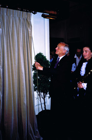
Photograph, City of St Kilda Centenary 1990 - images collection #2, 02/12/1990
... was commemorated 100 years later, on 2/12/1990, by the unveiling.../1895). This event was commemorated 100 years later, on 2/12 ...St Kilda was declared a city on 2/12/1890 by the Governor of Victoria The Right Hon. John Adrian Louis Hope, the Earl of Hopetoun, GCMG (28/11/1889 - 12/07/1895). This event was commemorated 100 years later, on 2/12/1990, by the unveiling of a plaque by the current Governor Dr J. Davis McCaughey AC (18/02/1986 - 22/04/1992). Also in commemoration of the centenary, a conservatory in the St Kilda Botanical Gardens was opened that day by the Mayor, Cr. Melanie Eagle. Four years later, in 1994, the City of St Kilda was amalgamated with the cities of South Melbourne and Port Melbourne to form the City of Port Phillip.Colour photographst kilda, st kilda town hall, governor davis mccaughey, st kilda city centenary, 1990, john callanan, j davis mccaughey, melanie eagle -
 Orbost & District Historical Society
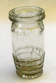
bottle, 1930 - 1950
... . Thirteen years later, the British-based Harry Peck & Co. began.... Thirteen years later, the British-based Harry Peck & Co. began ...Peck’s meat spreads were introduced in England in 1891. Thirteen years later, the British-based Harry Peck & Co. began exporting its products to Australia. By 1938, Peck’s set up in Australia and began making canned meat and fish products.This is an example of a food container used in the mid 20th century.A small clear moulded glass jar. It has a check pattern at the top and bottom with a smooth band in the middle. It has a wide opening tapering to the bottom. It is lipped for a rubber seal. It was used for Pecks paste.on base - PECKS with some indecipherable numberscontainer peck's-paste jar -
 Eltham District Historical Society Inc
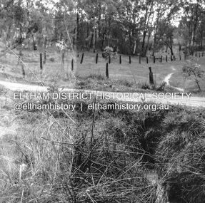
Negative - Photograph, J.A. McDonald, Fordhams Road, Eltham, 24 July 1962
... about 3pm on 24 July 1962 Heavy rain 60 years later it still... & Spicer about 3pm on 24 July 1962 Heavy rain 60 years later ...Culvert discharging towards land owned by Holloway & Spicer about 3pm on 24 July 1962 Heavy rain 60 years later it still appears to present as a concern - see Google Street View (Nov 2021) https://goo.gl/maps/x61yWvAc5UjJ2d8y9Record of various Shire of Eltham infrastructure works undertaken during the period of 1952-1962 involving bridge and road reconstruction projects, sometimes with Eltham Shire Council Project Reference numbers quoted. It was during this period that a number of significant improvements were made to roads and new bridges constructed within the shire that remain in place as of present day (2022). In many situations, the photos provide a tangible visible record of infrastructure that existed throughout the early days of the Shire. The album was put together by or under the direction of the Shire Engineer, J.A. McDonald.1962-07-24, culvert, eltham, fordhams road, infrastructure, shire of eltham -
 Eltham District Historical Society Inc
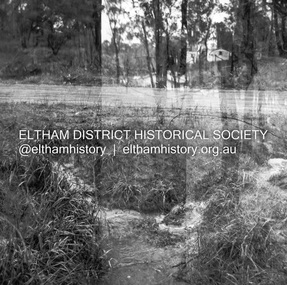
Negative - Photograph, J.A. McDonald, Fordhams Road, Eltham, 24 July 1962
... about 3pm on 24 July 1962 Heavy rain 60 years later it still... & Spicer about 3pm on 24 July 1962 Heavy rain 60 years later ...Culvert discharging towards land owned by Holloway & Spicer about 3pm on 24 July 1962 Heavy rain 60 years later it still appears to present as a concern - see Google Street View (Nov 2021) https://goo.gl/maps/x61yWvAc5UjJ2d8y9Record of various Shire of Eltham infrastructure works undertaken during the period of 1952-1962 involving bridge and road reconstruction projects, sometimes with Eltham Shire Council Project Reference numbers quoted. It was during this period that a number of significant improvements were made to roads and new bridges constructed within the shire that remain in place as of present day (2022). In many situations, the photos provide a tangible visible record of infrastructure that existed throughout the early days of the Shire. The album was put together by or under the direction of the Shire Engineer, J.A. McDonald.1962-07-24, culvert, eltham, fordhams road, infrastructure, shire of eltham -
 Federation University Historical Collection
Photograph - Photograph - Colour, Clare Gervasoni, Lorayne Branch visits the Ballarat School of Mines in Search of Henry Sutton, 2009, 2009
... to the Ballarat School of Mines. 10 years later the book 'Henry Sutton... of Mines. 10 years later the book 'Henry Sutton: Innovative Man ...Lorayne Branch's journey to write the definitive history of Henry Sutton received much impetus during this visit to the Ballarat School of Mines. 10 years later the book 'Henry Sutton: Innovative Man' was launched at the Federation University 'Ballarat School of Mines' campus..1) Left to right: Rex Bridges (Ballaarat Mechanics' Institute), Graeme Hood (Federation University Electrical Engineering Lecturer), Lorayne Branch and Jarrod Watt (ABC Ballarat) are engrossed in 'all things Henry'. .3) Descendant of Henry Sutton, Lorayne Branch (right) and University curator Clare Gervasoni stand in the Ballarat School of Mines Old Chemistry Building. Henry Sutton's early telephone would have 'rung' in this building. lorayne branch, jarrod watt, graham hood, clare gervasoni, henry sutton, ballarat school of mines, former sutton's music store, stained glass -
 Port Melbourne Historical & Preservation Society
Photograph - Ron Robertson, Ed Whiting and Jim Wood, Princes Pier, Port Melbourne, Nov 1935
... this location 10 years later as a repatriated Japanese prisoner of war... by Ed Whiting, who borrowed Ron's bike and later met him ...Donated by Ed Whiting, who borrowed Ron's bike and later met him at the pier. He notes that Ron returned past this location 10 years later as a repatriated Japanese prisoner of war. Ed served in the RAAF. Jim played for the Borough in 1950Photo of Ron Robertson of Nott St, Ed Whiting of Dow St and Jim Wood (just discernible at Ed's back) on Princes Pier 1935 (Cup Day weekend, traditional visit of the Navy)Stamp on back "Ëdwin Whiting" and addresspiers and wharves - princes pier, ron robertson, edwin whiting, jim wood -
 Whitehorse Historical Society Inc.
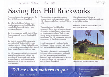
Article, Saving Box Hill Brickworks, Feb 2025
... and the landfill closed 25 years later and it would make an ideal park... and the landfill closed 25 years later and it would make an ideal park ...A community campaign is seeking to save the Box Hill Brickworks site for parkland.non-fictionA community campaign is seeking to save the Box Hill Brickworks site for parkland.suburban rail loop authority, box hill brickworks, wolahan keith mp -
 Warrnambool and District Historical Society Inc.
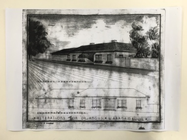
Document, Dr Angus residence plans, 1939
... ophthalmologist in his later years. Birchwood, with its beautiful gardens... later years. Birchwood, with its beautiful gardens, lawns ...These are plans for alterations to the residence and surgery of Dr Angus in Koroit Street, Warrnambool (Birchwood). Dr William Roy Angus (1901-1970), after several years practising as a doctor in South Australia and northern Victoria, came to Warrnambool in 1939, purchasing the practice of Dr John Hunter Henderson (Birchwood). Dr Angus was a dominant figure in medical and community circles in Warrnambool for 30 years, becoming an important ophthalmologist in his later years. Birchwood, with its beautiful gardens, lawns and tennis court was suitable for entertaining and many distinguished people, including Vice-Regal personnel and representatives of the Red Cross stayed at the house. It was also a meeting place for representatives of the many organizations with which Dr Angus was associated (over 20 groups including the Good Neighbour Council, the Boys’ Club, the Food For Britain appeal, the Historical Society, Rostrum and the National Fitness Council). Birchwood or earlier buildings on the site was used as a residence/surgery by many doctors in Warrnambool, going back to the 1860s and Dr Angus and his family lived there from 1939 to 1967. In 1998 Birchwood was demolished and a new Warrnambool Police Station was built on the site. These plans are of interest as they show the 1939 alterations to the building known as Birchwood in Koroit Street Warrnambool. We have a good floor plan and a drawing of the front of the building so we know what it looked like in the late 1930s. Both Birchwood and Dr Angus are important in Warrnambool’s history. These are four sheets showing alterations for the residence of Dr Angus (Birchwood) in Koroit Street Warrnambool. One sheet shows the front of the house in colour drawn in ink and pencil and paint and there is a copy of this in black and white. The other drawing is of the plans for the house drawn in pencil and ink and with some red and blue colouring. There is another exact copy of this sheet. dr william roy angus, birchwood, history of warrnambool -
 Victorian Bands' League
Cash Book, Victorian Bands' League Cash Book (Book 1) - 01/07/1931-30/06/1957, 1931
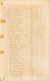
... to the League, and in later years there is detail on what the League... to the League, and in later years there is detail on what the League ...This cash book is one of the earliest administrative books that exist in the Victorian Bands' League historical collection. The earlier years contain records of which bands paid affiliation to the League, and in later years there is detail on what the League spent money on, and how much they received in Government grants. Mentioned throughout the cash book are the names of prominent bandsmen and brass bands. Interestingly in the later pages of the records, for some reason a new page numbering system was used before it reverted back to single pages. Table of Contents: 1931 – p1-p3 1932 – p3-p12 1933 – p13-p14 1934 – p15-p19 1935 – p20-p21 1936 – p22-p23 1937 – p24-p25 1938 – p26-p27 1939 – p28-p29 1940 – p30-p31 1941 – p32-p33 1942 – p34-p35 1943 – p36 1944 – p37 1945 – p38 1946 – p39 1947 – p40-p41 1948 – p42 1949 – p43 1950 – p44-p45 1951 – p46-p46-2 1952 – p47-pp47-2 1953 – p48 1954 – p48-2 1955 – p49-p50 1956 – p51-p52 1957 – p53This notebook is significant to the history of the Victorian Bands' League as it details some very early history of the League from when it commenced operation in 1931. We see here lists of the first brass bands to affiliate with the League, as well as expenses that were paid out to various organisations and individuals. Aside from the historical details, we can also see changes in treasurer and the obvious changes in handwriting over the years.Card bound notebook with pages ruled with accounting linesvictorian bands' league, brass bands -
 St Kilda Historical Society
Booklet - Diary, Price, F G, War Diary F. G. Price, 1916-1919
... , exactly 3 years later, on 3 June 1919...., a sister ship to Persic, exactly 3 years later, on 3 June 1919 ...A detailed account of Pte Price's experience of WWI from his embarkation to his return. Sections include: Description of Journey (Arrival at Albany WA; From Albany to Cape Town; Cape Town to Vincent, Verde Island; The Village Blacksmith; Four Days Holiday in London; Back at Camp; Second Visit to London); Review by King George; Zeppelin Air Raids; Embarking for France; The Idea of a Raid; St Omer; Battle of Messines; Bombardment Prior to Advance on Messines; A Visit to France by King George & Prince of Wales; Five Days March from Senlicques; First Battle of Ypres; Preparation for Second Battle of Ypres; 14 Days Leave from France to England; 14 Days Sick Leave62 pages, typewritten, on white paper with a brown paper cover. Bound along one side by 3 brass metal fasteners.non-fictionA detailed account of Pte Price's experience of WWI from his embarkation to his return. Sections include: Description of Journey (Arrival at Albany WA; From Albany to Cape Town; Cape Town to Vincent, Verde Island; The Village Blacksmith; Four Days Holiday in London; Back at Camp; Second Visit to London); Review by King George; Zeppelin Air Raids; Embarking for France; The Idea of a Raid; St Omer; Battle of Messines; Bombardment Prior to Advance on Messines; A Visit to France by King George & Prince of Wales; Five Days March from Senlicques; First Battle of Ypres; Preparation for Second Battle of Ypres; 14 Days Leave from France to England; 14 Days Sick Leavewwi, world war i, f g price