Showing 512 items
matching line plan
-
 Bendigo Historical Society Inc.
Map - COMET MINE - LONGITUDINAL SECTION COMET MINE
Longitudinal section of the Comet Mine on the Hustler's Line of Reef Bulletin No 33, Plate No XXVI signed by H. S. Whitelaw, Underground Survey Office Bendigo, September 1913. Map shows datum lines, depths of levels, approximate boundaries and references to other plans. Note - Plates 4, 8, 13, 20, 26 and 31 form a Longitudinal Section from Fortuna Hustler's to Hustler's Consols Mine. This item has not been scanned or photographed.Geological Survey of Victoriamining, parish map, hustler's line of reef, longitudinal section of comet mine bulletin no 33 plate no xxvi, h s whitelaw, underground survey office bendigo september 1913 -
Bendigo Historical Society Inc.
Map - COMET MINE - PLAN OF COMET MINE
Plan of the Comet Mine on the Hustler's Line of Reefs Bulletin No 33, Plate No XXIV signed by H S Whitelaw, Underground Survey Office Bendigo, September 1913. Upper and Lower Levels and approximate boundaries shown. Depths shown.Geological Survey of Victoriamining, parish map, hustler's line of reefs, comet mine plan bulletin no 33 plate no xxiv -
Bendigo Historical Society Inc.
Document - HERCULES AND ENERGETIC MINES - NOTES ON THE HERCULES AND ENERGETIC MINES
Four typed copies of notes on the Hercules and Energetic Mines. Notes include Location, depth of shafts, plant and machinery, Early History and Prominence. Reference: Mines Dept Special Edition Australian Mining Standard 1.6.1899, Mines Dept Booklet Bendigo Goldfield 1936, Mines Dept Annual and Quarterly Reports, Annals of Bendigo Mining Sections 1876 - 1921, A Richardson, The Bendigo Goldfield Registry J N Macartney 1.3.1871, Mines Dept Bulletin No 30 h Herman 1914, Bendigo Amalgamated Goldfields Coy Financial Reports 1920.mine, gold, hercules and energetic mines, hercules and energetic mines, notes on the hercules and energetic mines, the hercules, the energetic, the north energetic, the victoria pilot, plan of leases of 1870, bendigo amalgamated goldfields company, sheepshead line, wheat owl, central blue, big blue, mines dept special edition australian mining standard 1.6.1899, mines dept booklet bendigo goldfield 1936, mines dept annual and quarterly reports, annals of bendigo mining sections 1876 - 1921, a richardson, the bendigo goldfield registry j n macartney 1.3.1871, mines dept bulletin no 30 h herman 1914, bendigo amalgamated goldfields coy financial reports 1920 -
Bendigo Historical Society Inc.
Document - LANSELL'S BIG 180 MINE - CONDENSED HISTORICAL RECORD OF LANSELL'S BIG 180 MINE
Two handwritten and three typed copies of a Condensed Historical Record of Lansell's Big 180 Mine on the New Chum Line of Reef. Notes include location, shaft, first worked, size of lease, plant, engine house, boiler rooms, mullock heap, early history, Prominent, best gold, underground connections, pressurised hot water, diamond drill bores and a table with depths and the increase in temperature with the depth (in Fahr).document, gold, lansell's big 180 mine, lansell's big 180 mine, condensed historical record of lansell's big 180 mine, wittscheibe, ballerstadt, ernst mueller, theodore ballerstadt, george lansell, north old chum, victoria quartz, mines dept special edition 'australian mining standard' 1/6/1899, mines dept booklet 'bendigo goldfield' 1936, quarterly reports, lansell's 180 mine 'transverse sections, annals of bendigo mining sections, a richardson's observations from old photographs and measurements of mining plans, measurements taked from caleb thomas' report mines dept 1875, 'report on observation of underground temperature at bendigo' james stirling government geologist 1899, a richardson -
 Bendigo Historical Society Inc.
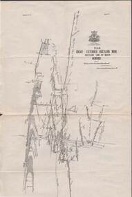
Map - STRUGNELL COLLECTION: HUSTLER'S LINE OF REEFS, BENDIGO, September 1913
Map, Hustler's Line of Reefs, Great Extended Hustler's Mine Plan, Plate No. X1 (11). Bulletin No 33 Signed H.A.Whitelaw Underground survey Office Bendigo September 1913.Underground Survey Office, Bendigo.map, bendigo, great extended hustler's mine -
 Bendigo Historical Society Inc.
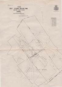
Map - STRUGNELL COLLECTION: HUSTLER'S LINE OF REEFS, BENDIGO, September 1913
Map, Hustler's Line of Reefs, Great Extended Hustler's Mine Plan,Plate No X (10).Bulletin No 33 Signed H.A.Whitelaw Underground survey Office Bendigo September 1913 Drawing has a table showing depths of levelsUnderground Survey Office, Bendigo.map, bendigo, great extended hustler's mine -
 Bendigo Historical Society Inc.
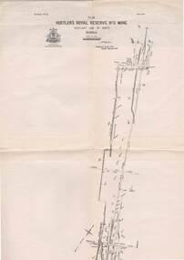
Map - STRUGNELL COLLECTION: HUSTLER'S LINE OF REEFS, BENDIGO, September 1913
Map, Hustler's Line of Reefs, Hustler's Royal Reserve No.2 Mine, Bendigo Plan. Plate No.V1 (6). Bulletin No 33 Signed H.A.Whitelaw Underground survey Office Bendigo September 1913Underground Survey Office, Bendigo.map, bendigo, hustler's royal reserve no. 2 mine* -
 Bendigo Historical Society Inc.
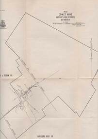
Map - STRUGNELL COLLECTION: HUSTLER'S LINE OF REEFS, BENDIGO
Map, Hustler's Line of Reefs, Comet Mine, Plan, Plate No. XX111 (23).Lightning Hill Anticline at Surface, United Hustler's & Redan Co., Hustler's Reef Co..Bulletin No 33 Signed H.A.Whitelaw Underground survey Office Bendigo September 1913Underground Survey Office, Bendigo. -
 Bendigo Historical Society Inc.
Map - STRUGNELL COLLECTION: HUSTLER'S LINE OF REEFS, BENDIGO, September 1913
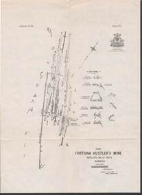
Map, Hustler's Line of Reefs, Fortuna Hustler's Mine, Plan, Plate No.11(2).Bulletin No 33 Signed H.A.Whitelaw.Underground Survey Office, Bendigo.map, bendigo, fortuna hustler's mine -
 Bendigo Historical Society Inc.
Map - STRUGNELL COLLECTION: HUSTLER'S LINE OF REEFS, September 1913
Map, Hustler's Line of Reefs, Hustler's Reef & Hustler's Reef No1 Mines Plan, Bendigo.Plate No. XV11 (17).Bulletin No 33 Signed H.A.Whitelaw.Underground Survey Office, Bendigo.map, bendigo, hustler's reef & hustler's reef 1 -
 Bendigo Historical Society Inc.
Map - STRUGNELL COLLECTION: HUSTLER'S LINE OF REEFS, September 1913
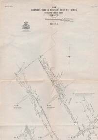
Map, Hustler's Line of Reefs, Hustler's Reef & Hustler's Reef No.1 Mines, Plan view . Plate No. XV (15).Sheet 1 Bulletin No. 33. Included is the emblem of the Geological Survey of Victoria. Signed by H.A.Whitelaw Underground Survey Office, Bendigo, Septembe ,1913.Underground Survey Office, Bendigo.map, bendigo, hustler's reef & hustler's reef 1 -
 Bendigo Historical Society Inc.
Map - STRUGNELL COLLECTION: HUSTLER'S LINE OF REEFS, September 1913
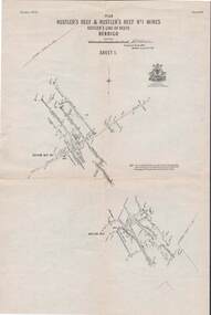
Map, Hustler's Line of Reefs, Hustler's Reef & Hustler's Reef No.1 Mines Plan.Plate No. XV1.(16) Sheet 2 .Bulletin No 33 Signed H.A.Whitelaw.Underground Survey Office, Bendigo, September,1913. Included is the emblem of the Geological Survey of Victoria. Drawing shows a plan view of reefs and shaft locations .Underground Survey Office, Bendigomap, bendigo, hustler's reef & hustler's reef 1 -
 Bendigo Historical Society Inc.
Document - CAMBRIDGE PRESS COLLECTION: ACCOUNT - G. J. SWEENEY AND SON
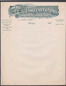
Note/account paper with date line ending 192-. Lined paper with greenish grey printed letterhead G. J. Sweeney & Sons Propriety Limited, Railway Steam Saw, Moulding and Planing Mills. Printed letterhead has a building with two tall chimneys and a horse and lorry at the side on the left and the name and phone number on the right side. Also Mining timber prepared. On the back is a stamped Sample with Cambridge Press and the date 26/4/24. Stamped in blue.business, printers, cambridge press, cambridge press collection, g j sweeney & sons proprietary limited, cambridge press -
 Bendigo Historical Society Inc.
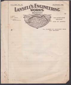
Document - CAMBRIDGE PRESS COLLECTION: ACCOUNT - LANSELL'S ENGINEERING
Note/account paper with brown printed letterhead. Date line with 192-. Lansell's Engineering Works Bendigo across the top. Below is a shape with a locality plan of Bendigo and a dark brown line going from Charing Cross to Lansell's Engineering Works via View St, Barnard ST and Inglewood Rd where it turns left into a smaller unnamed street. On the left are the names of E. Lansell, E F V Norbury and L V Lansell (Managing Director).business, printers, cambridge press, cambridge press collection, lansell's engineering works, charing cross, sterry's hotel, lansell's 180, e lansell, e f v norbury, l v lansell -
Bendigo Historical Society Inc.
Map - CAMPBELL COLLECTION: BENDIGO AND DISTRICT MAPS, 21-8-1972
Map. Shire of Strathfieldsaye Locality Plan. Scale 1 inch=1 mile. Drawn by M.Higgs 21-8-1972, Shire of Huntly, Shire of McIvor, City of Bendigo, Shire of Marong, Shire of Maldon, Shire of Metcalfe, Lake Eppalock, Axedale Township, Strathfieldsaye Township, Melbourne to Bendigo Railway Line, Big Hill Tunnel, Mt.Herbert 1596. (number 398 in map cupboard 1)M.Higgs 21-8-1972map, bendigo, locality plan -
Bendigo Historical Society Inc.
Map - CAMPBELL COLLECTION: BENDIGO AND DISTRICT MAPS, 21-8-1972
Map. Shire of Strathfieldsaye, Locality Plan. Scale I inch=1 mile. Shire of Huntly, Shire of McIvor, City of Bendigo, Shire of Marong, Shire of Maldon, Shire of Metcalfe. Lake Eppalock. Mileage markers on some roads. Melbourne to Bendigo Railway Line, Big Hill Tunnel, Mt.Herbert 1596.Axedale Township, Strathfieldsaye Township.M.Higgs 21-8-1972map, bendigo, locality plan -
Port Melbourne Historical & Preservation Society
Plan - Proposed bridge under Hobsons Bay railway at Clarendon Street, Emerald Hill, 1854 - 1884
... . Flood level re Sandridge line is shown. Plan Proposed bridge ...Plan of proposed bridge under Hobson's Bay Railway at Clarendon Street, Emerald Hill, affecting Sandridge railway and Sandridge Road. Flood level re Sandridge line is shown.transport - railways, flood, emerald hill, town planning -
 Port Melbourne Historical & Preservation Society
Plan - Ship plans, Melbourne Harbor Trust, 1980s
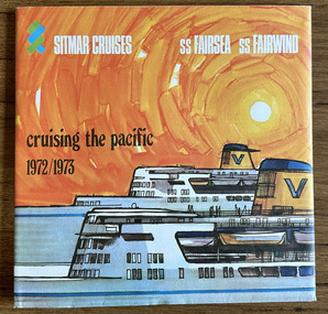
Ship Plans In 2 boxes labelled "Harbour Trust" .01 Flotta Lauro .02 Sea Princess .03 Shaw Saville - Ocean Monarch- MV Akaroa - Mv Arawa - MV Aranda .04 Chandris - Britanis - Queen Frederica .05 Sitmar - TV Fairsky - SS Fairsea - SS Fairwind - Fairstar .06 SS United States - Marco Polo - Monterey- Mariposamelbourne harbor trust - port of melbourne authority, flotta lauro, sea princess, ocean monarch, shaw savill, p & o, lauro line, britanis, chandris lines, sitmar, fairstar, fairsky, fairwind, marco polo, monterey, mariposa, ss united states, united states line, royal interocan lines, mv tswingi, mv akorda, mv arawa, mv aranda, queen frederica, fairsea, transport - shipping -
Port Melbourne Historical & Preservation Society
Plan, Department of Lands and Survey, The Township of Sandridge, 25 Nov 1860
Plan of the township of Sandridge lithographed at the department of Lands and Survey, Melbourne 5th November, 1860. Identical to 1859 version except for added rail line through Sandridge and onto Town Pierengineering - roads streets lanes and footpaths, municipal district of sandridge -
Port Melbourne Historical & Preservation Society
Plan - Victorian Railways 'single line diagram 'Port Store', Victorian Railways, Nov 1942
... of 'single line diagram' for 'Port Store' Plan Victorian Railways ...Diagrams created by the Victorian Railways with detailed information including weight of rails, distance of points/switches from the datum point, etc.Scanned copy of 'single line diagram' for 'Port Store'victorian railways, port store -
Port Melbourne Historical & Preservation Society
Plan - Victorian Railways 'single line diagram 'Princes Pier', Victorian Railways, Oct 1954
... ' Plan Victorian Railways 'single line diagram 'Princes Pier ...Diagrams created by the Victorian Railways with detailed information including weight of rails, distance of points/switches from the datum point, etc.Scanned copy of 'single line diagram' for 'Princes Pier'victorian railways, piers and wharves - princes pier -
Port Melbourne Historical & Preservation Society
Plan - Proposed footbridge over the Lagoon, Bridge Street, Port Melbourne, 1863
... of proposed footbridge over the Lagoon in line of Bridge Street Plan ...Plan of proposed footbridge over the Lagoon in line of Bridge StreetIn ink on reverse, two small drawings: elevation land view over a distance of 25.00 chains (colour tinted), and Plan view, section of an unidentified street:In pencil on reverse, notation '107 Albert Street'sandridge lagoon, robert h morgan -
Port Melbourne Historical & Preservation Society
Plan - Sandridge and adjacent suburbs, 1860
Photocopy of plan of Sandridge c1860 and adjacent suburbs from Pt Ormond to Pt Gellibrand at Williamstown on the bay and Melbourne to Hawthorn to the north. Shows the loop railway line which connected the St Kilda line to that at Windsor.On back in pencil 'From Alex St John 4/1998'town planning, transport - railways -
 Bendigo Historical Society Inc.
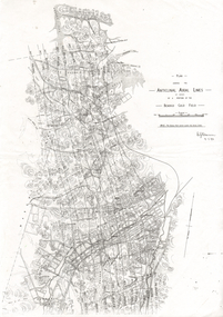
Document - LONG GULLY HISTORY GROUP COLLECTION: ANTICLINAL AXIAL LINES - BENDIGO GOLD FIELD
... Line Lightning Line plan shewing the Anticlinal Axial lines ...plan shewing the Anticlinal Axial lines of a portion of the Bendigo gold Field.bendigo, history, long gully history group, the long gully history group - anticlinal axial lines - bendigo gold field, e j dunn, christmas line, thistle line, carshalton line, napoleon line, nell gwynne line, new chum line, sheepshead line, deborah line, garden gully line, paddy's gully line, derby line, miller's line, hustlers line, lightning line -
 Bendigo Historical Society Inc.
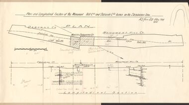
Document - MCCOLL, RANKIN AND STANISTREET COLLECTION: MONUMENT HILL CO., DEBORAH CO. LEASE ON DEBORAH LINE
Plan of Monument Hill Co., and Deborah Co. leases on the Deborah line. Black line drawing, showing longitudinal section. 'Deborah shaft to Nth Deborah 1100 ft ' noted in pencil . 'Nth Deborah shaft to Central Deb shaft 2000ft' in pencil. Other pencil notation on map re distance of leases. Map is attached to back page of booklet, rest of information missing.business, mining, mccoll rankin & stanistreet -
 Bendigo Historical Society Inc.
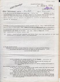
Document - MCCOLL, RANKIN AND STANISTREET COLLECTION: INDENTURE NORTH DEBORAH MINING COMPANY, 20th November, 1952
6 page document ' Gold Mining Lease Crown land Number 11307 Bendigo' plus map. Indenture document between Queen Elizabeth 11 and North Deborah Mining Company No Liability, Parish of Sandhurst, dated 20th November, 1952 re Vol 333, Folio 053. Land indicated by yellow on map and below ' a depth of one hundred and fifty feet from the surface of the land indicated by purple colour and delineated on the plan' Document signed by J. Stanistreet, Manager, North Deborah Mining Company No Liability. Map, fixed to document, heading ' Mining District of Bendigo, No. 11307, County of Bendigo, Parish of Sandhurst, Total area 13 acres 2 roods, 11 perches. Map shows large dam on Crown land, transmission line excised 150 ft., written on purple area. Underneath map ' provided that the dam indicated on the said plan is hereby reserved'.bendigo, mining, north deborah mining company -
 Bendigo Historical Society Inc.
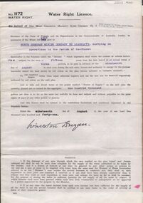
Document - MCCOLL, RANKIN AND STANISTREET COLLECTION: WATER RIGHT LICENCE NORTH DEBORAH MINING COMPANY NO LIABILITY, 19th August, 1941
4 page document plus map, Water Right Licence No. 1172, between King George VI ( the Crown ) and North Deborah Mining Company No Liability, Parish of Sandhurst., dated 19th August 1941. "to take and divert water at the points marked 'source of supply' on the said plan the quantity thereof not to exceed in the aggregate one hundred thousand gallons per diem' Plan: 'Mining District of Bendigo No. 1172 W.R., County of Bendigo, Parish of Sandhurst. Plan has dam area coloured in red, with pipe line drawn in red, leading from Battery marked on lease 11145 across lease 9988 to dam. Streets marked: Adams Road, Honeybone Street, Griston Street. (Golden Square area)bendigo, mining, north deborah mining company, north deborah mining company, adams, honeybone, and griston streets. (golden square) -
 Bendigo Historical Society Inc.
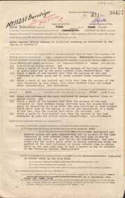
Document - MCCOLL, RANKIN AND STANISTREET COLLECTION: GOLD MINING LEASE NORTH DEBORAH MINING COMPANY, 29th August, 1950
6 page indenture, plus plan, between King George V and North Deborah Mining Company in the Parish of Sandhurst, dated 29th August, 1950 to operate a gold mine. Indenture numbered 11231 Bendigo, Vol 331 and Folio 36457. Plan shows Hargreaves Street, Violet Street, Lily Street, Sullivan Street railway line, and leases numbered, 11230; 2107; 11062, 11033, 11013, 11219, 11175. Shafts and tracks indicated. Dam shown on lease 11013. Scale 8 CHAINS TO A INCH. Coloured key to plan shows depths, Crown Land, and surface excised. Total area of lease 48 acres, 3 roods, 22 perches.bendigo, mining, north deborag mining company, north deborah mining company, hargreaves, violet, lilly, sullivan streets. -
 Bendigo Historical Society Inc.
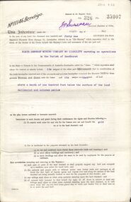
Document - MCCOLL, RANKIN AND STANISTREET COLLECTION: GOLD MINING LEASE NORTH DEBORAH MINING COMPANY, 6th May, 1941
6 page indenture document plus plan, between King George VI and North Deborah Mining company, no liability, Parish of Sandhurst, dated 6th May 1941. Lease number 11146 Bendigo. ' all that piece of land above a depth of one hundred feet below the surface of the land delineated and coloured yellow' Signed by J. Stanistreet, manager. Plan shows excised area in pink. Excised below 100ft shown in yellow ( lease 11146 ) On top of plan ' Mining district of Bendigo, County of Bendigo, Parish of Sandhurst. Area section has been amended to show 1 rood, 14 perches. Leases on plan : No. 9988, 11013, 11062, 11033, 11146, 10753, 11020. Streets: Sullivan Street, Hargreaves Street, Violet Street, Queen Street, King Street. Railway line shown. Scale 8 chains to 1 inch.bendigo, mining, north deborah mining company, north deborah mine, j stanistreet, sullivan heargreaves, queen, king streets. -
 Bendigo Historical Society Inc.
Document - MCCOLL, RANKIN AND STANISTREET COLLECTION: GREAT SOUTHERN EXTENDED, 1934
Documents: folder contains - plan of area applied for on Lease No. 10486 - 1934, 1933 application for mining lease, 1934 application for mining lease. Great Southern Extended and South New Chum.MCCOLL RANKIN AND STANSISTREETorganization, business, gold mining - legal, mccoll rankin and stansistreet, great southern extended, new chum line.