Showing 335 items
matching map box
-
 Surrey Hills Historical Society Collection
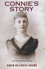
Book, Connie's Story: Commemorating the life of Mrs Edward (Plorn) Dickens, 2014
Purchased by the Surrey Hills Historical Society for the Surrey Hills Neighbourhood Centre History collection. Includes: illustrations, maps, portraits. Connie Dickens is believed to have spent some of her last year(s) in Surrey Hills. Traces the life of Mrs Edward (Plorn) Dickens, born in 1859 at River-View, Kangaroo Point, Tasmania, the third daughter of Alfred and Emily Desailly (nee Stanfield).Traces the life of Mrs Edward (Plorn) Dickens, born in 1859 at River-View, Kangaroo Point, Tasmania, the third daughter of Alfred and Emily Desailly (nee Stanfield).(mrs) constance emily rose dickens, (mrs) edward (plorn) dickens, (dr) (mr) francis desailly, (mr) alfred desailly, (miss) constance emily rosa desailly, (miss) emily desailly, (miss) florence eva desailly, (mrs) (ann) nancy sophia desailly, box hill cemetery -
 Federation University Art Collection
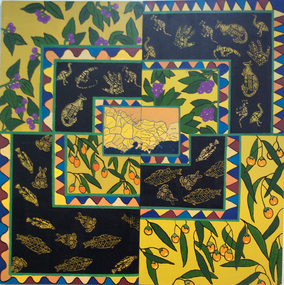
Painting - Artwork, [Untitled]
Under the direction of lecturer Raymond Thomas five students of Koorie Studies at the Gippsland Centre for Art and Design created this work. The were Vickie Turvey, Robyn Yates, Kellie Parsons, Melissa Fenton, Deanna Mobourne.A large canvas with indigenous plants, and Aboriginal animal motifs. If you can assist with information about this artwork, or the artist, please use the comment box below. artwork, artist, gippsland campus, aboriginal, kangaroo, emu, fish, clan map, vickie turvey, robyn yates, kellie parsons, melissa fenton, deanna mobourne, koorie studies -
 University of Melbourne, Burnley Campus Archives
Plan - Photocopy, Wendy Varcoe, Killamont, 1907? 1980?
Larger plan is probably of original fencing and drains from C.B. Luffman's layout. Killamont is the only known surviving private garden designed by Luffman.(1907).Photocopies of 2 hand drawn maps/plans of the garden at "Killamont." Drawn by Wendy Varcoe. Garden designed by C. B. Luffmann. (Also see B10.0040 Conservation Analysis and other C.B. Luffmann files in Box 75 A .)gardens, killamont, wendy varcoe, charles bogue luffman -
 City of Greater Bendigo - Civic Collection
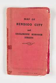
Map, Bolton Brothers Printers, Map of Bendigo City and Eaglehawk Borough Streets, Unknown
Produced by local company Bolton Brothers. Suitable for the glove box of car.Fold out map with a book style red and black printed front and back cover. Includes a three page index of street names and reference points. city of greater bendigo commerce, city of greater bendigo tourism -
 City of Greater Bendigo - Civic Collection
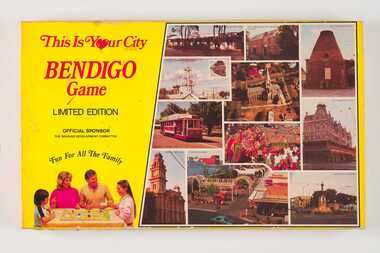
Leisure object - Board Game, E Systems Publications, This is Your City - Bendigo Game, 1985
This limited edition board game was produced in conjunction with local businesses and attractions and sponsored by the Bendigo Development Committee. Supported by the five local municipalities (pre amalgamation) and both State and Local governments, the role of the Committee was to promote Bendigo's economic development. Boxed board game. Yellow box lid featuring photographs of popular sights around Bendigo on right side and a family playing the game on the left on lid. Inside box includes game board, playing cards, dice and game rules. 0345a; Fold out game board. Commercially printed with a full colour stylised map of Bendigo and Eaglehawk. 0345b Set of 96 Destination Cards single side printing on coloured card 0345c Set of 32 Surprise Cards 0345d Paper money 0345e Player tokens 0345f Set of dice 0345g Letter to Players re the board game and local businesses on 'Bendigo Premier Town' letterhead. 0345h Three printed pages of discount vouchers for local businesses. 0345i Game Rulescity of bendigo premier town 1982-85, city of bendigo commerce -
 Beechworth RSL Sub-Branch
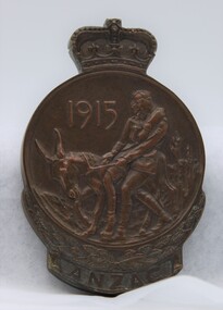
Anzac Commemorative Medallion
The Anzac Commemorative Medallion was instituted 1967. It was awarded to surviving members of the Australian forces who served on the Gallipoli Peninsula, or in direct support of the operations from close off shore, at any time during the period from the first Anzac Day in April 1915 to the date of final evacuation in January 1916. Next of kin, or other entitled persons, are entitled to receive the medallion on behalf of their relatives if the medallion has not been issued. Design The medallion is cast in bronze and is approximately 75 millimetres high and 50 millimetres wide. The obverse of the medallion depicts Simpson and his donkey carrying a wounded soldier to safety. It is bordered on the lower half by a laurel wreath above the word ANZAC. The reverse shows a map in relief of Australia and New Zealand superimposed by the Southern Cross. The lower half is bordered by New Zealand fern leaves. The name and initials of the recipient is engraved on the reverse. The medallion is issued in a presentation box. Badge Surviving members were also issued with a lapel badge in the form of a small replica of the medallion to recognise their Gallipoli service. This badge is not issued to other applicants.This medallion was presented to A. F. Hoffman a survivor of the Gallipoli Campaign. The medallion is cast in bronze and is approximately 75 millimeters high and 50 millimeters wide. The obverse of the medallion depicts Simpson and his donkey carrying a wounded soldier to safety. It is bordered on the lower half by a laurel wreath above the word ANZAC. The reverse shows a map in relief of Australia and New Zealand superimposed by the Southern Cross. The lower half is bordered by New Zealand fern leaves. The name and initials of the recipient is engraved on the reverse. The medallion is in the original presentation box that show wear from handling and ageThe recipients name is inscribed A.F. Hoffmanmedallion, anzac medellion, boxed medallion -
 Bacchus Marsh & District Historical Society
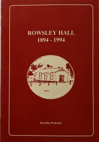
Booklet, Rowsley Hall 1894-1994
Rowsley is a rural locality 6km south-west of Bacchus Marsh. It is a very small community and the Rowsley Hall has been a community meeting place for over 100 years. This history tells the story of the origin of the Hall and its place in the community's history for its first 100 years. Citation: Rowsley Hall, 1894-1994, by Dorothy Pedretti. Published by Bacchus Marsh and District Historical Society, Bacchus Marsh, Vic., 1995?A small booklet. 36 unnumbered pages. Stapled binding. Contains black and white photographs, maps and facsimiles of documents. BMDHS Loc: AR/SU5/Pamphlets Box 4Rowsley is a rural locality 6km south-west of Bacchus Marsh. It is a very small community and the Rowsley Hall has been a community meeting place for over 100 years. This history tells the story of the origin of the Hall and its place in the community's history for its first 100 years. Citation: Rowsley Hall, 1894-1994, by Dorothy Pedretti. Published by Bacchus Marsh and District Historical Society, Bacchus Marsh, Vic., 1995?rowsley victoria history, halls, rowsley hall -
 Mont De Lancey
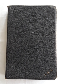
Book, Oxford University Press, 1. The Holy Bible, containing the Old and New Testaments 2. Daily Light on the Daily Path, Unknown
1. A Holy Bible containing the Old and New Testaments. At the back there is an Indexed Atlas to the Holy Bible with a List of maps and a List of Biblical Names. This is followed by twelve yellow and blue coloured maps of the Lands and Nations of the Bible. 2.A miniature book titled Daily Light on the Daily Path, A Devotional text book for everyday in the year..1. A black leatherette softcover Holy Bible contains the Old and New Testaments with the title and publisher Oxford printed in gold lettering on the spine. There are five embossed double lines on the spine too. On the front cover at the bottom right there is printed in gold lettering J.H.L. At the back there is an Indexed Atlas to the Holy Bible with a List of maps and a List of Biblical Names. This is followed by twelve yellow and blue coloured maps of the Lands and Nations of the Bible. The pages have gilt edges. 348p. Inside the front right hand side endpaper written in small blue handwriting is a prayer as written in the Inscription box below. 2. A miniature brown leatherette softcover book titled Daily light on the Daily Path - a devotional text book for every day of the year. The faded title is printed on the front cover at the top and on the spine. At the back there is a section For Special Occasions: Easter, Affliction, Marriage, Bereavement and others. There are two lists of the Daily Texts - the morning and evening hour arranged in biblical order. The edges of the pages are gilt. In the front is handwriiten in black ink - Neville Lordnon-fiction1. A Holy Bible containing the Old and New Testaments. At the back there is an Indexed Atlas to the Holy Bible with a List of maps and a List of Biblical Names. This is followed by twelve yellow and blue coloured maps of the Lands and Nations of the Bible. 2.A miniature book titled Daily Light on the Daily Path, A Devotional text book for everyday in the year..religious books, bibles, prayers -
 City of Kingston
Pamphlet - Colour, Roy Dunn Pty. Ltd, Central Corner Estate Moorabbin and Highett, c. 1923
Sales plan for land in the suburbs of Highett and Moorabbin, bordered by Point Nepean Road and Wickham Road East incorporating William StreetThe developing urban area of Highett and Moorabbin within the City of Kingston. This land sale pamphlet illustrates the subdivision of land within the municipality and the changing demographic of the district as new houses are constructed close to infrastructure.Colour pamphlet advertising for private sale land in the Central Corner Estate in Moorabbin and Highett. Incorporates a map of the estate bordered by Point Nepean Road and Wickham Road East, with subdivisions also available on both sides of William Street. Handwritten in blue pencil on subdivision plan: a tick is drawn on subdivisions 2-18 Handwritten in blue pencil on subdivision 6: a box with an x inside Handwritten in blue pencil on subdivisions 10 and 12: S Handwritten in black ink on front page: [indecipherable] / McKittricks Handwritten in grey pencil on rear page: McKilhick / Nepean Rd Handwritten in grey pencil on rear page upside down: 160000 / 15 8300 [crossed out] land sales, estate, highett, moorabbin -
 Department of Energy, Environment and Climate Action
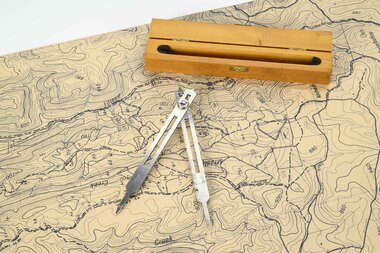
Mapping dividers
used to measure distances on mapsAdjustable stainless steel mapping dividers with wooden boxforests commission victoria (fcv), forest measurement, surveying, mapping -
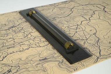 Department of Energy, Environment and Climate Action
Parallel ruler
Used to draw parallel lines on mapsHeavy metal ruler on brass rollers with a wooden boxforests commission victoria (fcv), surveying, mapping -
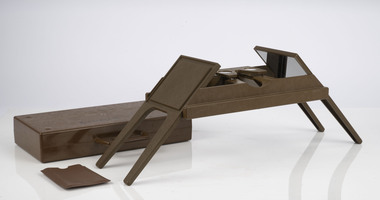 Department of Energy, Environment and Climate Action
Foldable Stereoscope
This stereoscope was used to view a pair of separate and overlapping aerial photos as a single three-dimensional image. This smaller foldable unit could be easily used in the field but larger, mirror stereoscope was used in offices. The aerial images were used to map forest types, timber stands, new roads and tracks, firebreaks, boundaries of timber harvesting, plantations, bushfires, insect and disease attack and so on In 1928, the Forests Commission undertook its first major aerial photography project over 15,000 acres of forest which is said to be the first of its kind in Australia. During the Second World War, large areas of Victoria were photographed by RAAF and used to produce orthophoto maps. By 1945 aerial photography of 13,000 square miles (3.4 M ha) was completed, including much of the inaccessible eastern forests. The Forests Commission started developing its own small format photography in the early 1970s. Simple, cheap and rapid methods of obtaining photographs using 70mm and 35mm cameras were developedFoldable plastic stereoscope in box Benallaforests commission victoria (fcv), surveying, forest measurement -
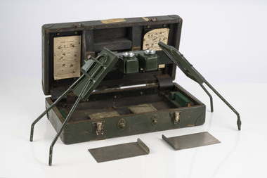 Department of Energy, Environment and Climate Action
Stereoscope
This stereoscope was used to view a pair of separate and overlapping aerial photos as a single three-dimensional image. Smaller units and could be easily used in the field but this larger, mirror stereoscope was used in offices. The aerial images were used to map forest types, timber stands, new roads and tracks, firebreaks, boundaries of timber harvesting, plantations, bushfires, insect and disease attack and so on In 1928, the Forests Commission undertook its first major aerial photography project over 15,000 acres of forest which is said to be the first of its kind in Australia. During the Second World War, large areas of Victoria were photographed by RAAF and used to produce orthophoto maps. By 1945 aerial photography of 13,000 square miles (3.4 M ha) was completed, including much of the inaccessible eastern forests. The Forests Commission started developing its own small format photography in the early 1970s. Simple, cheap and rapid methods of obtaining photographs using 70mm and 35mm cameras were developedFoldable metal stereoscope in wooden box with mirror covers Ex Dept of Defenceforests commission victoria (fcv), surveying, forest measurement -
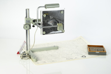 Department of Energy, Environment and Climate Action
Zeiss Sketchmaster
... , various lens in sperate box, adjustable light, map holder..., various lens in sperate box, adjustable light, map holder ...The Zeiss Sketchmaster was used to transfer information from aerial photographs onto scale maps. The operator views the aerial photograph and the map simultaneously and manually traces detail from the photograph onto the map. It utilises the principle of the camera lucida, patented in 1806. Various lens combinations were used on a to adjust for scale and then “rubber sheet” the image to line up topographic features like streams and roads. The photo information was then laboriously transferred using a light table onto large A0 paper maps or translucent drafting film. The maps were later hand coloured with either Derwent pencils or delicately painted with Pelikan ink wash. This item is kept at Erica.Zeiss Sketchmaster. c1970s. Includes adjustable stand, various lens in sperate box, adjustable light, map holder and magnetsforests commission victoria (fcv), forest measurement, mapping, surveying -
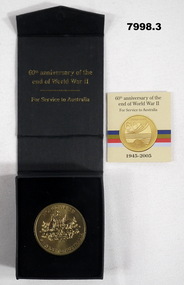 Bendigo Military Museum
Memorabilia - COMMEMORATIVE MEDALLION, Australian Government, Department of Veterans' Affairs, Office of Australian War Graves, 2005
Part of the Cooper Collection.1. Gold coloured metal medallion. The obverse features the Australian Coat of Arms with text "WORLD WAR II, SERVICE TO AUSTRALIA. The reverse symbolises land (Army) Sea (Navy) and Air (RAAF) on a stylized map of Australia. Text "WORLD WAR II, 60 YEARS, 1945-2005". 2. Black coloured cardboard box with hinged lid and magnetic catch. Navy blue felt covered insert to fit medallion. Gold coloured text on top of and inside of box. 3. Four page insert with text. 4. Commemorative certificate with text.2. Printed in gold on cover: 'Australian Government, Department of Veterans Affairs.' Australian Coat of Arms above text. Printed on inside of bar in gold text: "60th Anniversary of the end of World War II, for Services to Australia." 3. cooper collection, ww2, memorabilia, commemorative medallion -
 Ringwood and District Historical Society
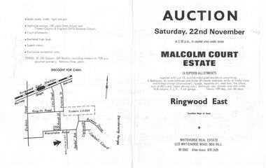
Flyer, Land Auction Brochure, Malcolm Court Estate, Ringwood East, Vic. - 1969
Bi-folded single sheet with black print both sides advertising Auction on Saturday, 22nd November, 1969. Details include location map, vendor terms, subdivision features and local facilities. Centre page shows allotment numbers and property dimensions. Agent - Whitehorse Real Estate, 1123 Whitehorse Road, Box Hill, (Phone) 890502, After hours 8781429. Separate copy of map with handwritten sale notations for some allotments.LP 859686 -
 Surrey Hills Historical Society Collection
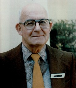
Photograph, Alan Holt
Alan Holt was keenly interested in the history of Surrey Hills. He worked in the Lands Department and drew up maps of the area based on research he conducted there in his spare time and after retirement. He also compiled a survey of owners / occupants of all Surrey Hills listings from Sands & MacDougall directories at 10 year intervals. These are meticulously entered into hand-written ledgers. All his work is also entered on to index cards. With a lifetime's knowledge of local history and research techniques, Alan found himself after retirement, in constant demand as an amateur historian working for the Box Hill Historical Society and the History Group of the Surrey Hills Neighbourhood Centre. When the Surrey Hills Historical Society was formed, Alan and Edna became its first and only Life Members. Alan began work in the Department of Crown Lands and Survey. In the 1950s-60s he moved to the Premier's Department where he assisted with the planning for the Queen's 1954 visit. He was promoted to Permanent Head of the Lands Department until retirement in 1972. He was associated with the Surrey Hills Uniting Church all his life. There is a copy of this photo in a brass frame.A colour portrait photo of the late Alan Holt.alan holt -
Box Hill Historical Society
Book, John M. Wilkins, Transforming Victoria 1894-1994: a Century of Electricity Supply by Victoria's Local Government 1894-1994 and the S.E.C.V. 1921-1994, 2017
A chronological history of electricity supply in Victoria by local government and by the State Electricity Commission231 pages. Includes maps, graphs, bibliography and index. Also includes colour and black & white photos non-fictionA chronological history of electricity supply in Victoria by local government and by the State Electricity Commissionbox hill electricity supply, electricity supply, state electricity commission of victoria, secv -
 Melbourne Tram Museum
Ephemera - Timetables - MMTB Buses, Melbourne & Metropolitan Tramways Board (MMTB)
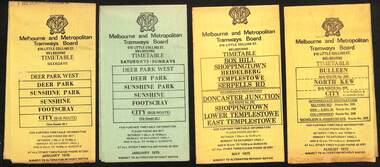
Timetables - provide information on ticketing, fares, timing points, with a description of the route and a map. Not all services had been allocated a route number at the time. 1 - Deer Park West - Sunshine - Footscray - City - Jan 1975, including a separate weekend timetable' 2 - Box Hill - Shoppingtown - Templestowe - May 1975 3 - Bulleen - North Kew City - Routes 203, 204, 205, 206, 208 and 209 - August 1972 4 - North Altona - City - route 232 - June 1979 5 - Clifton Hill - Elsternwick route - route 246, Point Ormond - route 247 and 248 - June 1974 6 - La Trobe University - Northland - West Heidelberg - City - routes 256, 251, 253, 254, 252, 255 - August 1974 7 - Warrandyte - Park Orchards - Ringwood - routes 273, 274, 275 - Feb. 1974 8 - Warrandyte - Donvale - Templestowe - Shoppingtown - City - routes 276, 277, 278, 294, 278, 280, 299, 268 - April 1975 9 - East Kew, Box Hill Doncaster, Shoppingtown - routes 284, 285, 270 - May 1974 10 - Box Hill - Mitcham, East Doncaster, Ringwood - routes 287, 286, 288, 282, 283, 272 - March 1974' 11 - Box Hill - North Blackburn - route 290 - March 1974 12 - Fishermans Bend - City - routes 233, 235, 237 - Feb 1979.Yields information about MMTB Bus services during the 1970s.Set of twelve MMTB Bus timetables - multifolded printed on yellow paper, except for Deer Park timetables for Saturdays and Sundays printed on green paper.timetable, the met, buses, box hill, doncaster, templestowe, warrandyte, elsternwick, fishermans bend, deer park, altona, sunshine, footscray, shoppingtown -
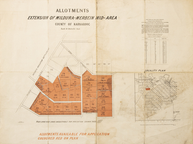 Merbein District Historical Society
Map - Allotments Extension of Mildura-Merbein Mid-Area, Allotments available, 23 November 1920
Allotments available to Discharged Soldiers Discharged Soldier's Settlement Act Historic Large map, folded in 4, coloured map of Merbein indicating allotments available and locality plan. Scale 10 chain to 1 inchPhoto-Lithographed at Department of lands Survey, Melbourne J. Butson 23.11.20discharged soldiers, ww1, soldier settlement, irrigation -
Merbein District Historical Society
Map, Merbein Irrigation District Drainage Systems, 5 Dec.1936
drainage, irrigation -
Merbein District Historical Society
Document, Merbein Cemetery Location map, unknown
merbein township, cemetery -
Merbein District Historical Society
Map, Township of Yelta, 30 Aug.1968
yelta -
Merbein District Historical Society
Map, Township of Yelta (Cowanna), 1958
yelta -
Merbein District Historical Society
Map, Township of Yelta, Jul.1968
yelta -
Merbein District Historical Society
Map, Township of Yelta, Jul.1968
yelta -
Merbein District Historical Society
Map, Township of Yelta (Cowanna), 1958
yelta -
Merbein District Historical Society
Map, Township of Yelta, 30 Aug.1968
yelta -
Merbein District Historical Society
Map, Road Construction Authority Shire of Mildura, Aug.1986
merbein, roads, shire of mildura -
Merbein District Historical Society
Map, State Rivers & Water Supply Commission-Merbein Urban District n.d, unknown
state rivers and water supply commission, merbein township