Showing 566 items
matching melbourne argus
-
 Greensborough Historical Society
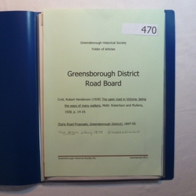
Folder, Greensborough District Roads Board, 1847o
Contents: The open road in Victoria [excerpt] by R H Croll; Newspaper articles on early road proposals in Greensborough area; Newspaper article from The Argus on Embezzelment of monies from Roads Board.20-page plastic binder, blue cover. Contains documents relating to the Greensborough District Roads Board.greensborough district roads board, robert henderson croll, charles buck -
 Eltham District Historical Society Inc
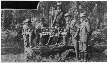
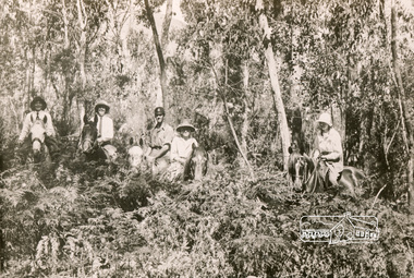
Photograph, Members of the Committee of Management of the Kinglake National Park who spent the week-end inspecting the improvements in this beautiful forest reserve
L-R: Prof. J. Neill Greenwood, Messrs. H. Hewitt and A.B. Blair (Sec.), Prof. W.A. Laver (Chairman) and Mr. W. Thorn. Source: Dr. Edith J. Hewitt from The Argus, 11 Jan 1930This photo forms part of a collection of photographs gathered by the Shire of Eltham for their centenary project book,"Pioneers and Painters: 100 years of the Shire of Eltham" by Alan Marshall (1971). The collection of over 500 images is held in partnership between Eltham District Historical Society and Yarra Plenty Regional Library (Eltham Library) and is now formally known as the 'The Shire of Eltham Pioneers Photograph Collection.' It is significant in being the first community sourced collection representing the places and people of the Shire's first one hundred years.Digital imagesepp, shire of eltham pioneers photograph collection, kinglake, committee of management, a.b. blair, h. hewitt, kinglake national park, prof. j. neil greenwood, prof. w.a. laver, w. thorn -
 Eltham District Historical Society Inc
Photograph, Bend of Islands, c.1926
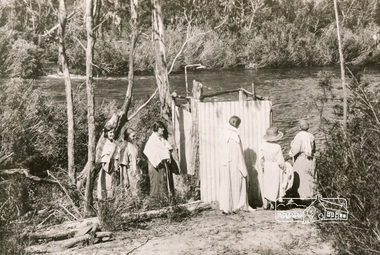
Bend of Islands is named after a group of small islands at a bend of the Yarra River near Watsons Creek. It is located near the town of Kangaroo Ground. The locationn was a long time favourite spot for locals and visitors to fish and swim in the river. This is one of a series of four photographs that depict a mainly young group of people recreating in the area, particularly enjoying horse riding. Possibly weekend campers. Photos taken about 1926-1928. In 1938 "The Argus" advertised weekend cabins at the Bend of Islands estate 5-are Yarra Yarra frontage in the Christmas Hills Gorge ideal for weekend cabins. "Bathing, fishing, canoeing, shooting may be enjoyed in ideal surroundings". This photo seems to be depicitng women waiting to use the shower near the river, or are they going swimming?Black and white photograph (reproduction)Bend of Islands, c.1926 bend of islands, camping, shower block, yarra river, swimming -
 Eltham District Historical Society Inc
Photograph, Bend of Islands, c.1926
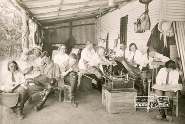
Bend of Islands is named after a group of small islands at a bend of the Yarra River near Watsons Creek. It is located near the town of Kangaroo Ground. The locationn was a long time favourite spot for locals and visitors to fish and swim in the river. This is one of a series of four photographs that depict a mainly young group of people recreating in the area, particularly enjoying horse riding. Possibly weekend campers. Photos taken about 1926-1928. In 1938 "The Argus" advertised weekend cabins at the Bend of Islands estate 5-are Yarra Yarra frontage in the Christmas Hills Gorge ideal for weekend cabins. "Bathing, fishing, canoeing, shooting may be enjoyed in ideal surroundings". Was this a church group? This photo depicts individuals "resting" on a verandah undertaking various solo activities including listening to their gramophone.Black and white photograph (reproduction)Bend of Islands, c.1926 bend of islands, camping, recreation, gramophone, group, campers -
 Eltham District Historical Society Inc
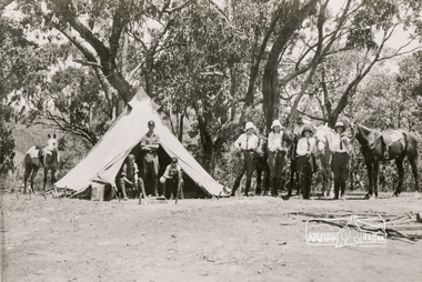
Photograph, Bend of Islands, c.1928
Bend of Islands is named after a group of small islands at a bend of the Yarra River near Watsons Creek. It is located near the town of Kangaroo Ground. The locationn was a long time favourite spot for locals and visitors to fish and swim in the river. This is one of a series of four photographs that depict a mainly young group of people recreating in the area, particularly enjoying horse riding. Possibly weekend campers. Photos taken about 1926-1928. In 1938 "The Argus" advertised weekend cabins at the Bend of Islands estate 5-are Yarra Yarra frontage in the Christmas Hills Gorge ideal for weekend cabins. "Bathing, fishing, canoeing, shooting may be enjoyed in ideal surroundings". Black and white photograph (reproduction)Bend of Islands, c.1928 bend of islands, horse riding, camping, tent -
 Eltham District Historical Society Inc
Photograph, Bend of Islands
Bend of Islands is named after a group of small islands at a bend of the Yarra River near Watsons Creek. It is located near the town of Kangaroo Ground. The locationn was a long time favourite spot for locals and visitors to fish and swim in the river. This is one of a series of four photographs that depict a mainly young group of people recreating in the area, particularly enjoying horse riding. Possibly weekend campers. Photos taken about 1926-1928. In 1938 "The Argus" advertised weekend cabins at the Bend of Islands estate 5-are Yarra Yarra frontage in the Christmas Hills Gorge ideal for weekend cabins. "Bathing, fishing, canoeing, shooting may be enjoyed in ideal surroundings". Black and white photograph (reproduction)Bend of Islands bend of islands, camping, tent, horse riding -
 4th/19th Prince of Wales's Light Horse Regiment Unit History Room
Photograph, The Argus Newspaper, 1950's
Previously, band members had a war function as stretcher bearers.Black & white photo of a soldier on a stretcher having his leg bandaged. A dozen or so are standing around watching. There are band instruments in the left foreground. This appears to be members of 4/19 PWLH Band receiving first aid training at an annual camp of the Regiment.Copyright photo - stamp of "The Argus" on backband, first aid -
 Warrnambool and District Historical Society Inc.
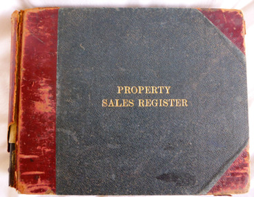
Document - Book, Arnall & Jackson, Printers, lithographers, bookbinders, publishers, manufacturing stationers. 428 Collins St Melbourne, Book Property Sales Register, Circa 1944
This ledger contains listings of purchasers of properties within Warrnambool area during the period 1944 to 1950.This ledger provides a comprehensive list of names and properties in the period 1944 -1950. It lists sales for a number of well -known properties both private and commercial.Dark green hard cover with maroon corners and spine binding. Title is in gold lettering on front cover. Alphabetical index at the front followed by 145 pages of ledger pages. Inside front cover are a number of cuttings from the Warrnambool Standard and the Argus dating from around 1900-1911. Arnall & Jackson**** Lithographers. Printers and manufacturing stationers.warrnambool, property ledger, sales ledger, warrnambool property 1944-1950 -
 Eltham District Historical Society Inc
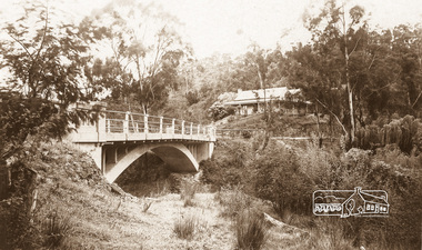
Negative - Photograph, The Bridge, Hurstbridge, Vic, c.1925
Copied from brochure "Wattle Valley Estate" 7 minutes from the bridge. The new bridge designed by Sir John Monash over the Diamond Creek near Hurst's home of 'Mia Mia' at Hurstbridge. The Wattle Valley Estate was first advertised in August 1925 as weekend building allotments by the Greater Melbourne Land and Development Company. Advertised from £28.10.0 or £60 per block. In August 1926, 30 picked allotments of 60x150 feet were put up for auction Saturday August 14, 1926 with frontages to Valley View Road and Fawkner Crescent advertised in the “Heart of the Glorious Wattle Country” and “Within 15 Minutes of the Newly Electrified Railway Station”. The Advertiser on August 13, 1926 in an article promoting the auction stated “the estate is regarded as one of the best in the district, and will be sold practically without reserve.” It is noted that an advertisement running in The Argus February 22, 1951 offered the remaining 16 blocks for sale at £12.10.0 or £200 the lot. By March 7, the remaining blocks were advertised at £17.10.0 The Wattle Valley Estate took over 20 years to sell and then people could not build on them This image was also used in a brochure advertising the "Wattle Valley Estate", which forms part of the Shire of Eltham Pioneers Photograph Collection (Cross Reference Photo No.(s): 1056, 1057)This photo forms part of a collection of photographs gathered by the Shire of Eltham for their centenary project book,"Pioneers and Painters: 100 years of the Shire of Eltham" by Alan Marshall (1971). The collection of over 500 images is held in partnership between Eltham District Historical Society and Yarra Plenty Regional Library (Eltham Library) and is now formally known as the 'The Shire of Eltham Pioneers Photograph Collection.' It is significant in being the first community sourced collection representing the places and people of the Shire's first one hundred years.Digital image 4 x 5 inch B&W Negshire of eltham pioneers photograph collection, hurstbridge, bridge, diamond creek (creek), monash bridge, wattle valley estate -
 Eltham District Historical Society Inc
Negative - Photograph, Rose Stereograph Company, The Bridge, Hurstbridge, Vic, c.1925
Copied from brochure "Wattle Valley Estate". The new bridge designed by Sir John Monash over the Diamond Creek near Hurst's original home "Mia Mia" seen in the distance. Reprinted from brochure advertising "Wattle Valley Estate" 7 minutes from bridge. The Wattle Valley Estate was first advertised in August 1925 as weekend building allotments by the Greater Melbourne Land and Development Company. Advertised from £28.10.0 or £60 per block. In August 1926, 30 picked allotments of 60x150 feet were put up for auction Saturday August 14, 1926 with frontages to Valley View Road and Fawkner Crescent advertised in the “Heart of the Glorious Wattle Country” and “Within 15 Minutes of the Newly Electrified Railway Station”. The Advertiser on August 13, 1926 in an article promoting the auction stated “the estate is regarded as one of the best in the district, and will be sold practically without reserve.” It is noted that an advertisement running in The Argus February 22, 1951 offered the remaining 16 blocks for sale at £12.10.0 or £200 the lot. By March 7, the remaining blocks were advertised at £17.10.0 The Wattle Valley Estate took over 20 years to sell and then people could not build on them This image was also used in a brochure advertising the "Wattle Valley Estate", which forms part of the Shire of Eltham Pioneers Photograph Collection (Cross Reference Photo No.(s): 1056, 1057). Also cross reference SEPP_1028 / 29 for other views of Mia Mia. Part of a slide show presentation "Bridges & Waterways of the Shire" by Russell Yeoman to the 13 September 1989 Society meeting. The presentation included slides of historic photos from the Shire of Eltham Pioneers collections as well as several recent views. This photo forms part of a collection of photographs gathered by the Shire of Eltham for their centenary project book,"Pioneers and Painters: 100 years of the Shire of Eltham" by Alan Marshall (1971). The collection of over 500 images is held in partnership between Eltham District Historical Society and Yarra Plenty Regional Library (Eltham Library) and is now formally known as the 'The Shire of Eltham Pioneers Photograph Collection.' It is significant in being the first community sourced collection representing the places and people of the Shire's first one hundred years.Digital image 4 x 5 inch B&W Negshire of eltham pioneers photograph collection, hurstbridge, mia mia, bridge, diamond creek (creek), monash bridge, wattle valley estate -
 Eltham District Historical Society Inc
Negative - Photograph, Popular Picnicing at Hurstbridge, c.1925
Picnickers enjoying a Sunday outing near the Wattle Valley Estate at Hurstbridge. Copied from brochure "Wattle Valley Estate". It is believed the picture is taken at the northwest corner of the intersection of Wattletree Road and Hurstbridge-Arthurs Creek Road looking southeast towards the township (most likely where the house is located on the property of what is today No. 2 Wattletree Road)- https://goo.gl/maps/VDorwCe1rJJUapjE6 According to a comment by Jean Verso (via @nillumbikcouncil FB page 3 Jan 2020) - "This view is from Wattle Tree Road with Haleys Gully Road to the right and across the creek to William Gray's nursery at Allwood. The building to the far left looks like Dorset House. The building on the left in the middle distance is still there today and has been used for storage and as a stable/tack room for a number of years." The Wattle Valley Estate was first advertised in August 1925 as weekend building allotments by the Greater Melbourne Land and Development Company. Advertised from £28.10.0 or £60 per block. In August 1926, 30 picked allotments of 60x150 feet were put up for auction Saturday August 14, 1926 with frontages to Valley View Road and Fawkner Crescent advertised in the “Heart of the Glorious Wattle Country” and “Within 15 Minutes of the Newly Electrified Railway Station”. The Advertiser on August 13, 1926 in an article promoting the auction stated “the estate is regarded as one of the best in the district, and will be sold practically without reserve.” It is noted that an advertisement running in The Argus February 22, 1951 offered the remaining 16 blocks for sale at £12.10.0 or £200 the lot. By March 7, the remaining blocks were advertised at £17.10.0 The Wattle Valley Estate took over 20 years to sell and then people could not build on them Cross Ref EDHS_02665 Rose Series Postcard P. 4341, "View at Hurstbridge, Vic." Also, other images from sales brochure SEPP_1055 / 1056This photo forms part of a collection of photographs gathered by the Shire of Eltham for their centenary project book,"Pioneers and Painters: 100 years of the Shire of Eltham" by Alan Marshall (1971). The collection of over 500 images is held in partnership between Eltham District Historical Society and Yarra Plenty Regional Library (Eltham Library) and is now formally known as the 'The Shire of Eltham Pioneers Photograph Collection.' It is significant in being the first community sourced collection representing the places and people of the Shire's first one hundred years.Digital image 4 x 5 inch B&W Neg1925, dorset house, fawkner crescent, haleys gully road, hurstbridge, hurstbridge-arthurs creek road, picnic, postcards, shire of eltham pioneers photograph collection, valley view road, wattle valley estate, wattletree road, exhibition yprl 2019-12 -
 Eltham District Historical Society Inc
Photograph, Eltham - Floods in 1934
To the left of picture is the Main Road Bridge over the Diamond Creek in Eltham South when the Diamond Creek was in flood. The Yarra also was in flood. In early December 1934 the "Greatest flood in the history of the Yarra" occured, according to The Argus newspaper. Bridges and houses were swept away with hundreds of people left homeless across the state. The historic 1934 flood of the Diamond Creek and Yarra River set the criteria for future planning with respect to flood water rise.This photo forms part of a collection of photographs gathered by the Shire of Eltham for their centenary project book, "Pioneers and Painters: 100 years of the Shire of Eltham" by Alan Marshall (1971). The collection of over 500 images is held in partnership between Eltham District Historical Society and Yarra Plenty Regional Library (Eltham Library) and is now formally known as 'The Shire of Eltham Pioneers Photograph Collection.' It is significant in being the first community sourced collection representing the places and people of the Shire's first one hundred years.Digital image 4 x 5 inch B&W Negsepp, shire of eltham pioneers photograph collection, eltham, diamond creek (river), 1934 flood, diamond creek, floods, main road bridge -
 Eltham District Historical Society Inc
Photograph, Floodwaters, Diamond Creek, Eltham, 1934
The Diamond Creek in flood near the Main Road bridge at Eltham, Victoria. The Yarra also was in flood. In early December 1934 the "Greatest flood in the history of the Yarra" occured, according to The Argus newspaper. Bridges and houses were swept away with hundreds of people left homeless across the state. The historic 1934 flood of the Diamond Creek and Yarra River set the criteria for future planning with respect to flood water rise.This photo forms part of a collection of photographs gathered by the Shire of Eltham for their centenary project book, "Pioneers and Painters: 100 years of the Shire of Eltham" by Alan Marshall (1971). The collection of over 500 images is held in partnership between Eltham District Historical Society and Yarra Plenty Regional Library (Eltham Library) and is now formally known as 'The Shire of Eltham Pioneers Photograph Collection.' It is significant in being the first community sourced collection representing the places and people of the Shire's first one hundred years.Digital image 4 x 5 inch B&W Neg (2 frames on one neg) 9 x 15.5 cm B&W printflooding, eltham, shire of eltham pioneers photograph collection, sepp, diamond creek (river), floods, 1934 flood, diamond creek -
 Eltham District Historical Society Inc
Photograph - Postcard, Rose Stereograph Company, View at Hurstbridge, Vic, c.1925
Rose Series Postcard P. 4341 “View at Hurstbridge, Vic.” Picnickers enjoying a Sunday outing near the Wattle Valley Estate at Hurstbridge. Copied from brochure "Wattle Valley Estate". It is believed the picture is taken at the northwest corner of the intersection of Wattletree Road and Hurstbridge-Arthurs Creek Road looking southeast towards the township (most likely where the house is located on the property of what is today No. 2 Wattletree Road)- https://goo.gl/maps/VDorwCe1rJJUapjE6 According to a comment by Jean Verso (via @nillumbikcouncil FB page 3 Jan 2020) - "This view is from Wattle Tree Road with Haleys Gully Road to the right and across the creek to William Gray's nursery at Allwood. The building to the far left looks like Dorset House. The building on the left in the middle distance is still there today and has been used for storage and as a stable/tack room for a number of years." The Wattle Valley Estate was first advertised in August 1925 as weekend building allotments by the Greater Melbourne Land and Development Company. Advertised from £28.10.0 or £60 per block. In August 1926, 30 picked allotments of 60x150 feet were put up for auction Saturday August 14, 1926 with frontages to Valley View Road and Fawkner Crescent advertised in the “Heart of the Glorious Wattle Country” and “Within 15 Minutes of the Newly Electrified Railway Station”. The Advertiser on August 13, 1926 in an article promoting the auction stated “the estate is regarded as one of the best in the district, and will be sold practically without reserve.” It is noted that an advertisement running in The Argus February 22, 1951 offered the remaining 16 blocks for sale at £12.10.0 or £200 the lot. By March 7, the remaining blocks were advertised at £17.10.0 The Wattle Valley Estate took over 20 years to sell and then people could not build on them Cross Ref SEPP_1057, “Popular Picnicing at Hurstbridge” rcopied from Wattle Valley estate sales brochure.Digital file only Postcards scanned from the collection of Michael Aitken on loan to EDHS, 13 Feb 20181925, dorset house, exhibition yprl 2019-12, fawkner crescent, haleys gully road, hurstbridge, hurstbridge-arthurs creek road, michael aitken collection, picnic, postcards, rose stereograph company, shire of eltham pioneers photograph collection, valley view road, wattle valley estate, wattletree road -
 Eltham District Historical Society Inc
Photograph - Postcard, The Bridge, Hurstbridge, Vic
Arched Bridge (Monash Bridge) The Rose Series P. 4036 Reproduced in a brochure advertising the "Wattle Valley Estate" 7 minutes from the bridge. The new bridge designed by Sir John Monash over the Diamond Creek near Hurst's original home "Mia Mia" seen in the distance. The Wattle Valley Estate was first advertised in August 1925 as weekend building allotments by the Greater Melbourne Land and Development Company. Advertised from £28.10.0 or £60 per block. In August 1926, 30 picked allotments of 60x150 feet were put up for auction Saturday August 14, 1926 with frontages to Valley View Road and Fawkner Crescent advertised in the “Heart of the Glorious Wattle Country” and “Within 15 Minutes of the Newly Electrified Railway Station”. The Advertiser on August 13, 1926 in an article promoting the auction stated “the estate is regarded as one of the best in the district, and will be sold practically without reserve.” It is noted that an advertisement running in The Argus February 22, 1951 offered the remaining 16 blocks for sale at £12.10.0 or £200 the lot. By March 7, the remaining blocks were advertised at £17.10.0 The Wattle Valley Estate took over 20 years to sell and then people could not build on them.Digital file only Postcards scanned from the collection of Michael Aitken on loan to EDHS, 13 Feb 2018michael aitken collection, postcards, hurstbridge, monash bridge, bridge, diamond creek (creek), mia mia, shire of eltham pioneers photograph collection, wattle valley estate -
 Orbost & District Historical Society
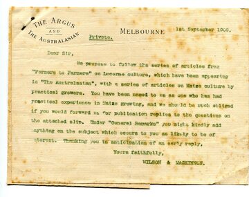
letter, September 1 1909
When early settlers began to arrive on the Snowy River somewhere in the 1880s, the land was mostly swamps and heavily timbered jungle on the river frontages. The swamps were drained bit by bit using hand tools. The frontages were cleared by axe and shovel and fire. Several kinds of crops were experimented with such as hops, hemp and maize. Maize grew particularly well and became the main crop of the district. (info. from October 2006 ODHS Newsletter) The Argus was a morning daily newspaper in Melbourne, Australia that was established in 1846 and closed in 1957. It was considered to be the general Australian newspaper of record for this period.Maize-growing has been an important agricultural industry in the Orbost district since early settlement. This item is associated with that history.A typed letter sent to a local maize farmer requesting information on maize growing. The letter has the "Argus" letter head. The name of the recipient is unknown.maize agriculture-orbost correspondence-argus -
 Ringwood and District Historical Society
Photograph, Building the old Ringwood Baths in Ringwood St. 1934, incl Newspaper Articles
Black and white photograph. Several articles from Ringwood newspapers and the Argus (images attached) show the initial idea as Nov 1933 (3000-01 Ringwood Baths-Idea.jpg), Commencement in January 1934 (3000-02 Ringwood Baths-Start.jpg), and operational by November 1934 (3000-03 Ringwood Baths-Operational.jpg). An Argus article (via Trove) from 15 Mar 1934 describes a union complaint about use of workers on sustenance in the construction.(3000-04 Ringwood Baths-Complaint.jpg) Typed below photograph, "Building the old Ringwood Baths in Ringwood St. Looking towards Warrandyte Rd. 1934. -
 Ringwood and District Historical Society
Booklet - Newsletter, Warrandyte Historical Society Inc. - The First Gold Field in Victoria - How l discovered it, by Louis John Michel, 1896
Personal recollections of Louis John Michel after the events which he described in The Argus on Saturday 28 December 1895 -
 Orbost & District Historical Society
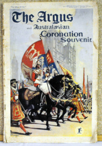
magazine, The Argus and Australasian Coronation Souvenir 24 May 1937, 24 May 1937
The Argus was a morning daily newspaper in Melbourne that was established in 1846 and closed in 1957 and was considered to be the general Australian newspaper of record for this period. Widely known as a conservative newspaper for most of its history. George VI became King after his brother, King Edward VIII, abdicated in 1936. The coronation of King George VI and Queen Elizabeth as King and Queen of the United Kingdom and the Dominions of the British Commonwealth and as Emperor and Empress of India took place at Westminster Abbey, London, on 12 May 1937. King George ascended the throne upon the abdication of his brother, King Edward VIII, on 10 December 1936, three days before his 41st birthday. Edward's coronation had been planned for 12 May 1937 and it was decided to continue with his brother and sister-in-law's coronation on the same date. This newspaper provides a detailed pictorial representation of the coronation of King George V1 in London on 12 May, 1937. The commonwealth countries, including Australia joined in the celebration. Saving an item dedicated to the royal family is typical of the general feeling of respect and admiration felt by the rural communities towards the British Royal Family.A special edition souvenir newspaper which is a forty page pictorial commemorating the Coronation of King George VI. It is titled "THE ARGUS and AUSTRALIAN CORONATION SOUVENIR". On the front cover is a coloured painting /print of a horse parade/procession with banners printed by "ROWED". In the bottom right corner is the cost - 1/-. It contains a complete record of the ceremonies as well as large portrait photos of the royal family designed for framing. argus-newspaper george-v1 coronation -
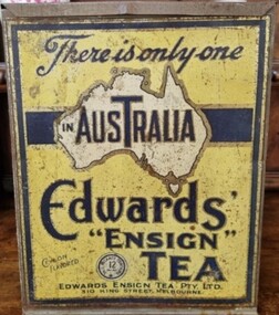 Flagstaff Hill Maritime Museum and Village
Container - Tin Tea Container, Wilson Bros, 1900-1940
The tin was made by Wilson Bros, Melbourne, for Edwards' Ensign Tea Pty Ltd, Melbourne, Victoria, Australia, 1900-1940. There was a fire at their factory in Flinders Street Melbourne on April 30, 1921 which completely destroyed the building. New premises were obtained at 310/18 King Street Melbourne in 1923. there continued to be bill board advertisements for Ensign tea at the King Street address, also regular adverts in the Argus newspaper during1942.An Australia icon during the first half of the 20th century as tea drinking was a popular past time and social activity.Container for tea with hinged lid. Label yellow with map of Australia. Lid is coming away on one hinge. "Edwards Ensign Tea" On label "Edwards Ensign Tea"flagstaff hill, warrnambool, shipwrecked coast, flagstaff hill maritime museum, maritime museum, shipwreck coast, flagstaff hill maritime village, great ocean road, tea tin, tea caddy, drink, container, wilson bros, ensign tea -
Marysville & District Historical Society
Document (Item) - Book extract, John (Jack) Cato, John William Lindt F.R.G.S. of Melbourne-The Story of the Camera in Australia, 1955
An account of the life of John Willliam Lindt extracted from the book The Story of the Camera in Australia.An account of the life of John Willliam Lindt extracted from the book The Story of the Camera in Australia. John William Lindt (1845–1926), was a German-born Australian landscape and ethnographic photographer, early photojournalist, and portraitist. John Lindt was responsible for a folio of photographs of the Fernshaw and Watts River area and he sold over 25,000 images of the Black Spur from his original negatives. In 1895 he was able to purchase land on the North East side of the Black Spur and subsequently built his home and guesthouse "The Hermitage" from where he continued his photographic career. In 1913 he collaborated with Nicholas Caire to produce a tourist booklet on the area. In 1925 the Argus reported that Lindt "continues to produce remarkable and most artistic pictures of the beauties of mountain landscape. He is not a believer in the blurred effects favoured by many ... instead he is a master of detail." Aged 81 Lindt died of heart failure during disastrous bushfires on 19 February 1926 at the Hermitage. He was survived by his wife Catherine who continued to run ‘The Hermitage’ guest house before she retired to the city. John (Jack) Cato was a keen photographer from an early age and was the author of The Story of the Camera in Australia which when it was first published in 1955, was the first history of Australian photography and photographs.john william lindt, fernshaw, watts river, black spur, the hermitage, nicholas, nicholas john caire, the argus, john (jack) cato, the story of the camera in australia -
Glen Eira Historical Society
Article - Miller, Hon Henry, MLC
Three items about other Miller family members: 1/Photocopied article and photograph of Muriel Miller (born 1890 approx.), wife of Septimus ‘Money’ Miller. Article from ‘who’s who in the world of women’, c1930s, giving brief family history, the charities she was involved with and her hobbies and interests. 2/Reprinted article from Argus newspaper dated 30/06/2013, regarding the will of the late Septimus Miller, husband of Murie Miller. 3/Photocopied copy of Miller family tree (1784 – 1990), where Muriel becomes Mrs. Miller 1912.miller septimus, miller helen mary muriel, henderson john, miller henry, miller ronald nevill damien, ‘cantala’, housenames, dandenong road, caulfield, wills -
Glen Eira Historical Society
Article - ELSTER AVENUE, 20, ELSTERNWICK
This file contains 5 items: 1/Handwritten notes of title search details compiled by Peta Darke, dated 25/07/2014. From 1909 to 1936. 2/Photocopy of six pages of handwritten details from title searches compiled by Peta Darke, dated 24/10/2014. From 1871 to 1920. 3/Handwritten list of Sands and McDougal entries from 1915 to 1970 and additional notes up to 2014, compiled by Peta Darke, dated 28/07/2014. 4/Photocopies of four advertisements concerning the property from The Argus as follows: 26/04/1919 page 17: property for sale; 10/05/1919 page 14: property for sale; 01/09/1917 page 13: a son born to Mrs. W. Robertson of ‘Struan’; 09/06/1928 page 2: mortgagee’s auction to be held. 5/Photocopy of colour photography of 20 Elster Avenue taken by R. Darke, approx. 1998.elsternwick, gardenvale, elster avenue, struan, kooyong road, parnell street, college street, lempriere john thompson, hawker lilian margaret, taylor mary maud, davison lily ann, pretty ralph, robinson charles, robinson william henry, robinson george augustus, inglis robert, davies matthew henry, ross william murray, calder william anderson, watson john, rosstown junction railway and property company, muntz street (now parnell street), rupert street, oswald street, peile edgar stoddart, robertson walter, davison walter, bays arthur, gluth william, petersen o. c., farnell thomas h., bennett william, mcdonald michael, donaldson william, ryan james s., diamond g., nirens george, nirens pamela, nirens paul, nirens linda, coburn helen, coburn graham, coburn laura, coburn george, architectural styles, edwardian style, brick houses -
Glen Eira Historical Society
Article - ELSTER AVENUE, 18, ELSTERNWICK
This file contains 5 items about this property: 1/Handwritten notes from titles searches of 18 Elster Avenue complied by Peta Darke dated 29/07/2014 – photocopy 7 pages. 2/Handwritten list of Sands & McDougall entries for 1915 to 1970, and notes to present, compiled by Peta Darke dated 29/07/2014. 3/Photocopy of two pages of the title to the property dated 22/10/1909. Includes plan of subdivision of the area. 4/Photocopies of five advertisements from The Argus relating to the property: 28/08/1918 Land Wanted 12/07/1921 Lost Heifer 26/04/1919 Owner has House For Sale (20 Elster Avenue) 10/05/1919 same – No. 20 For Sale 29/11/1927 M. M. Taylor has Oats and Barley For Sale. 5/Photocopy of photograph of exterior taken by R. Darke circa 1998.elsternwick, gardenvale, elster avenue, robinson charles, caulfield, robinson william henry, robinson george augustus, inglis robert, davies matthew henry, ross william murray, colonial investment and agency company, victorian permanent property investment and building society, calder william anderson, watson john, rosstown junction railway and property company, kooyong road, college street, parnell (muntz) street, lempriere john thomson, thomson william hamilton, collinson william morris, elizabeth street, cumming euphemia, taylor thomas, hill caroline, evans alexander cameron, evans horace, evans gordon lemaitre, roach joyce rubena, evans mary arthur, nallo luigi, nallo joyce, north road, darke richard alexander, darke peta, peile edgar stoddart, corio, darke caroline elizabeth, darke cameron andrew, oswald street, bertram street, taylor m. m., land subdivision, architectural styles, edwardian style, brick houses, teak street, caulfield south -
Glen Eira Historical Society
Article - ELSTER AVENUE, 16, ELSTERNWICK
This file contains 6 items: 1/Handwritten notes by Peta Darke dated 25/07/2014 listing title details for 16 Elster Avenue from 1909 to 2009 – two pages. 2/Handwritten list of Sands and McDougall entries for the property from 1915 to 1940 dated 25/07/2014 compiled by Peta Darke. 3/A photocopy of a Biggin Scott Real Estate Agents flyer advertising the recent sale of the property in 2009. 4/Print out from ‘The Argus’ of 04/12/1917, Page 6, from the Trove website of a brief article concerning the wounding of S.P.Jones, son of Stephen Jones of ‘Mons’, Elster Avenue in November 1917. 5/A photocopy of colour photograph of exterior of 16 Elster Avenue Circa 1998 taken by R.Darke. 6/Article from ‘Caulfield Glen Eira Leader’ of 25/03/2014, Page 3, concerning Oscar Jones, 14 year old son of present owners, who is an excellent surf life saver. Includes colour photograph of Oscar.elster avenue, college street, bowood, elsternwick, bowden arthur william, mons, hartington street, parnell street, jones stephen alma, kooyong road, kendall ann bell, kendall james william, kendall harold duncan, morrison harold lindsay, morrison rhonda may, cook jean isobel, golding ida curnow, perrett craig stuart, perrett eileen mary, perrett edward, perrett anthea, perrett catherine, lewis kay margaret, swain anthony barry gilles, swain darcy, swain mitchell, jones adrian, jones karine stehman, jones oscar, jones patrick, thomas lloyd, rickman jacob, lee james t, nidschelm harold, regan francis, jones douglas, laughton martin, biggin and scott, ashton daniel, jones stephen percy douglas, architectural styles, edwardian style, timber houses, gardenvale, collinson william morris, thomson william hamilton, lempriere john thompson -
Glen Eira Historical Society
Document - LEMPRIERE AVENUE
1/A newspaper cutting from The Argus 12/07/1927 (a print-out of same from Trove), praising the virtues of demolishing former mansion ‘Rozelle’ and erecting a ‘score’ of pretty modern villas from Balaclava Road directly into Green Meadows Gardens, a public reserve. Article describes modernity of homes in great details and the streetscape vistas (1 photo included) including road and pathways. 2/A Caulfield St Kilda Leader, dated 25/08/1993, article with Caulfield residents George and Edna McKaige wanting a planning amendment ‘with teeth’ to protect their Lempriere Ave streetscape. Andrew Ward, Heritage Architect, identified Lempriere Ave as one of Caulfield’s significant areas, because of its Interwar streetscape.east st kilda, ‘rozelle’ mansions, balaclava, land subdivision, balaclava road, georgian style, spanish mission style, orrong road, greenmeadows gardens, lempriere avenue, leadlight, mckaige george, power and telegraph lines, triple-fronted style, interwar streetscape, mckaige edna, ward andrew, caulfield council, elsternwick, welsh heather (councillor), councillors, akehurst jeff, caulfield heritage watch, spencer david, johnson john dr., ‘kilwinning’, george h., peterson william mrs., ‘melby’, ‘springfield’, rose-watt miss, ‘rozelle’, ‘cressy house’, meadow street, smith wallace m., heron herbert l., ‘goathland’, ‘melbe’, wright james, marsh malcolm reginald, house names, melby avenue, springfield avenue, goathlands street, kilwinning court, heritage studies, town planning -
Glen Eira Historical Society
Article - Sennit, William John
This file contains six items about William John Sennit, manufacturer who lived at 154 Balaclava Road Caulfield. Photocopied page from 500 Victorians, Centenary Edition, 1934 giving a brief biography and cartoon of W.J. Sennit. A print of the wedding notice from the Caulfield and Elsternwick Leader, 24/08/1901 of the marriage of W.J. Sennit to Miss. Lily Sage. A print of the obituary notice for W.J. Sennit from the Argus, dated 30/01/1940. A print from the funeral notice for W.J. Sennit from the Argus, 31/01/1940. Research notes from Melbourne and Victorian directories, 1913 and 1923 showing addresses. Other items about the history of Paul Sennit, father of W.J Sennit.sennit william john, caulfield, balaclava road, sennit john paul, food manufacturing, farnham, house names, sage lily, sennit ronald -
Glen Eira Historical Society
Document - Watts, Thomas
This file contains various information on architect Thomas Watts who resided at GLENHUNTLY. It includes a photocopied entry on Watts contained in Sutherland VICTORIA AND ITS METROPOLIS, annotated hand-written entries from a rates book on ownership of GLENHUNTLY, and hand-written note of an entry in THE ARGUS dated 26th July 1913 about Watts, a pencilled card for Watts and a photocopy of an article on the property GLENHUNTLY in THE SOUTHERN CROSS newspaper, dated 18th June 1986 Photocopy of photograph, date and photographer unknown, of Thomas Watts and his daughter Kate Two page document describing the papers of Thomas Watts held at the State Library of Victoria. A brief list of documents held at the library is included.watts thomas architect, orrong road, house, glenhuntly st marys, glenhuntly road, rosstown sugar works, school, caulfield common school, justice of the peace, watts kate, armstrong (nee watts) mrs j.a., local government, road districts, caulfield roads district, caulfield shire council, shire president, watts james salter, thomas watts and son, glen eira road, kooyong road, edenthorpe estate, watts estate, watts helen k -
Glen Eira Historical Society
Article - CAMDEN TOWN
This file contains three items. 1. Two copies of articles, dated 08/1857. The Argus neg 14 and roneoed copy neg 13 The Argus 16/07/1857 on benefits of living in Camden Town. 2. A photocopied photo of Camden Town Sports Club event undated and specific location unknown; and one photo on the corner of Glen Eira and Bambra Road. 3. Photocopied pages from Sands and McDougall 1874 of Caulfield c1900’s listing residents of Caulfield including Camden Town (three mentioned).‘camden town’, glenhuntly, east brighton road, watts t., surveyor, elsternwick, timbered, william gledhill (estate agent), camden town sports club, glen eira road, bambra road, attrill james t., o’brian john -
 Glen Eira Historical Society
Article - ‘REPTON’, ELM AVENUE, 10, ELSTERNWICK
This file contains six items about this mansion: 1/Three pages of handwritten notes by Peta Darke, dated December 2013, concerning the title and ownership of Repton from 1881 till 2013, earlier called ‘Wahgunyah’ 2/Handwritten list of owners of Repton from various editions of Sands and McDougall Directories compiled by Peta Darke on 06/12/2013 3/Black-and-white photograph of exterior of Repton, undated, photographer unknown 4/Seven copies each of a classified advertisement in The Argus newspaper relating to Repton and its occupiers. Dates are 15/01/1927, 15/12/1928, 07/03/1917, 10/07/1926, 02/07/1940, 10/04/1944, and 28/01/1949 5/Article in Property Review Weekly dated 15/11/2013 advertising forthcoming auction on 30/11/2013. Includes colour photographs of exterior and interior. Also brochure real estate agent advertising forthcoming auction of Repton: includes 4 colour photographs of exterior and interior, description of property and plan of layout. Produced in 2013. 6/Printed information taken from 'Trove' regarding former residents of 'Repton', Elm Street, Elsternwick by Claire Barton. Research is from the Stubss family tree about Dermot Du Moulin Ryan whose mother's address is listed as this property.repton, wahgunyah, elm avenue, elm road, elsternwick, roan andrew, partridge john douglas, partridge alice anna, partridge john roland phelps, phillips ida mary charlotte, steers reuben rivers, mann agnes, gruer william frank, taylor james alexander, marmaras george, marmaras arthur, supported housing, stevens edward, matthews herbert, repton court flats, marmara drive, lehte, fosbery avenue, taylor florence ethel, wood john frances wealth, brick houses, land subdivision, flats, victorian style, stubbs family, ryan dermot du moulin, ryan kate, elm street, house names, ryan h h