Showing 185205 items
matching melbourne-zoological-gardens
-
 Federation University Historical Collection
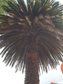
Photograph, Clare Gervasoni, Palm Tree in the Ballarat School of Mines Gardens, 23/04/2020
... Palm Tree in the Ballarat School of Mines Gardens ...The Ballarat School of Mines Botanical Gardens were established in 1879, and are situated at the rear of the current administration building. The gardens enabled the students to sit for examinations for registration by the Pharmacy Board of Victoria. An important aspect of this course was the study of Materia Medica, or botanical materials used for medicinal purposes.Colour photograph of a palm tree in the botanical garden sat the back of the Ballarat School of Mines Administration Building.smb botanical gardens, botanical gardens, smb, ballarat school of mines, school of mines ballarat, ballarat, photograph, phoenix dactylifera palmae, date palm, parks and gardens, landscape -
 Federation University Historical Collection
Photograph, Clare Gervasoni, Ballarat School of Mines Gardens with Palm Tree, 04/11/2019
... Ballarat School of Mines Gardens with Palm Tree ...The Ballarat School of Mines Botanical Gardens were established in 1879, and are situated at the rear of the current administration building. The gardens enabled the students to sit for examinations for registration by the Pharmacy Board of Victoria. An important aspect of this course was the study of Materia Medica, or botanical materials used for medicinal purposes.Colour photograph of a palm tree in the botanical garden sat the back of the Ballarat School of Mines Administration Building.smb botanical gardens, botanical gardens, smb, ballarat school of mines, school of mines ballarat, ballarat, photograph, palm tree -
 Port Melbourne Historical & Preservation Society
Booklet, City of Port Melbourne, Port Melbourne Resident's Handbook 1974-1975, 1974
Prepared by the Town Clerk's office of the City of Port Melbourne. Port Melbourne Resident's Handbook for 1974-5, providing details of Council services and other helpful information for residents. Later versions renamed 'Community Directories'. This volume includes a message from Mayor Perce WHITE. (Copy is #795)local government - city of port melbourne, mayors, perce mcguire white, perce white -
 Tatura Irrigation & Wartime Camps Museum
Photograph, Mactier Gardens, Hogan Street, Tatura
... Mactier Gardens, Hogan Street, Tatura ...Shows picture of Mactier Gardens, Hogan Street, Tatura,.Colour photograph showing Mactier Gardens, Hogan Street, Tatura. Photograph stuck onto piece of white cardboard. hogan street tatura, mactier gardens tatura -
 Port Melbourne Historical & Preservation Society
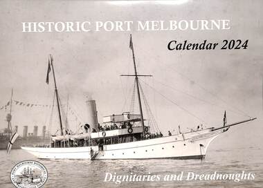
Document - Calendar 2024, Port Melbourne Historical & Preservation Society members, Historic Port Melbourne - Dignitaries and Dreadnoughts, September 2023
Researched, written and designed by PMHPS members.The cover of the 2024 "Historic Port Melbourne - Dignitaries and Dreadnoughts" produced by members of the Port Melbourne Historical & Preservation Society focuses on visits to Port Melbourne by naval shipping and dignitaries including Royal ambassadors. hmas franklin, armed services - navy, shenandoah, koln, idzumo, yakumo, sawagiri, hamayuki, hms hood, hms delphi, duke of york, duchess of york, royal yacht ophir, hms renown, hmas australia, uss seattle, uss nevada, uss oklahoma, great white fleet, hmas canberra, hmas sydney, hmas yarra, piers and wharves - princes pier, piers and wharves - station pier, duke of gloucester, hms sussex, prince alfred, hmcss victoria, hmas lonsdale, hmas perth, anzac squadron, hms king george v -
 Buninyong & District Historical Society
Photograph - Original B/W Photograph, View over the Gong towards the Buninyong Gardens, with established trees and early model motor vehicles
... View over the Gong towards the Buninyong Gardens, with...gardens ...The photograph, taken c 1940 show The Gong and the view to the Buninyong Gardens. The trees in the Gardens are well established and early model motor vehicles are seen parked on the Gong dam wall. The Gong and the Buninyong Botanic Gardens are iconic features of the town. They are of great historic, aesthetic and social significance. They are representative of early parklands.Original B/W photograph of the view over the Gong towards the Buninyong Gardens, with established trees and early model motor vehiclesthe gong, buninyong, gardens, botanic gardens, cars, parklands -
 Federation University Historical Collection
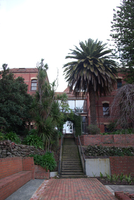
Photograph - Colour Photograph, Ballarat School of Mines Botanical Gardens, 15/08/2020
... Ballarat School of Mines Botanical Gardens ...The Ballarat School of Mines Botanical Garden was established in 1870, and was used by students of Materia Medica and Botany.Photograph of the Ballarat School of Mines Botanical Gardens Looking down hill towards o Building.ballarat school of mines botanical gardens, ballarat school of mines, materia medica, system garden, o building -
 Federation University Historical Collection
Photograph - Colour Photograph, Ballarat School of Mines Botanical Gardens, 15/08/2020
... Ballarat School of Mines Botanical Gardens ...The Ballarat School of Mines Botanical Garden was established in 1870, and was used by students of Materia Medica and Botany.Photograph of the Ballarat School of Mines Botanical Gardens Looking down hill towards P Building.ballarat school of mines botanical gardens, ballarat school of mines, materia medica, system garden -
 Eltham District Historical Society Inc
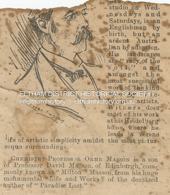
Newspaper - Newspaper Clipping, Melbourne Punch, Artist Walter Withers, PEOPLE WE KNOW, Melbourne Punch, June 17, p. 2, 1897
ARTIST WALTER WITHEBS, whose pictures are now on exhibition at his Melbourne studio on Wednesdays and Saturdays, is an Englishman by birth, but an ardent Australian by adoption. His landscapes are "racy of the soil,” and amongst the most successful work of the kind done by Victorian artists. Withers does most of his work at his Heidelberg home, where he leads a serene life of artistic simplicity amidst the most picturesque surroundings. PEOPLE WE KNOW (1897, June 17). Melbourne Punch (Vic. : 1855 - 1900), p. 2. Retrieved August 22, 2023, from http://nla.gov.au/nla.news-article174626232Journal inscribed: "Mrs Withers 463 Collins St. West Melbourne"art exhibition, art review, john withers collection, melbourne, walter withers studio, 463 collins street west, walter herbert withers, artist -
 Kew Historical Society Inc
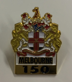
Souvenir, Lapel Pin, Melbourne 150, 1985, 1985
Melbourne 150A lapel pin in the shape of the coat of arms of the City of Melbourne with Melbourne 150 belowMelbourne 150 (front) Pinstop 869 9390 (reverse)melbourne 1834-1984, melbourne - 150th anniversary, souvenirs - lapel pins -
Port Melbourne Historical & Preservation Society
Magazine, Port Melbourne Football Club, The Burras 1988, Port Melbourne Football Club, 1988
"The Burras 1988, Port Melbourne Football Club". Magazine front cover has a red strip at top and blue strip along bottom. Between these is a black and white grainy photo of two players jumping for the ball. Back cover has a coloured advertisement for HDT vehicle specialists. Page of club information followed by page of local advertisments.sport - australian rules football, port melbourne football club, pmfc, alexander arthur james, woodruff farms pty ltd, olympia bay street cellars and foodmart, kevin hoare, idol sport -
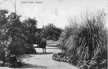 Stawell Historical Society Inc
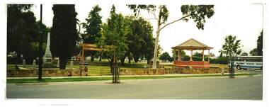
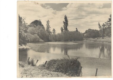
Photograph, Central Park Gardens c1900, c1900
... Central Park Gardens c1900 ...Central Park Gardens. Boy at center and large grass trees on right. c1900Post card showing a male standing in Central Park Gardens. Also an enlarged copy of the post card.stawell -
International House, The University of Melbourne
Film (Item), University of Melbourne Experimental Film Unit, Film: International House, Melbourne
This short documentary film was produced by the Melbourne University Film Society in 1954 to display the hopeful possibilities of an International House in Melbourne. It was played from May 4th-6th in the Union House Theatre, along with several other films produced by the Society, possibly scheduled to coincide with the fundraising International House Fair the following weekend. The film stars broadcaster and author Allan Aldous as commentator, and the Malaysian female student is thought to be Rajeswary Thambiah of Malaysia. The female student from Lang Lang is unknown, though may be named Wendy.1950s melbourne, international house -
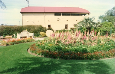 Stawell Historical Society Inc
Photograph, Central Park Gardens 1988 --- 3 Photos -- Coloured
... Central Park Gardens 1988 --- 3 Photos -- Coloured ...Three colour photographs Central Park Gardens Easter 1988Coloured photos of Central Park Gardens, one of No.1 Grandstand and the other two photos of the fountain in Central Park.Inscriptions on fountain postcards Easter flowers, Central Park Easter 1988stawell -
 Federation University Historical Collection
Print - Image, Ballarat School of Mines Botanical Gardens, c1953, 1953
... Ballarat School of Mines Botanical Gardens, c1953 ...School of Mines Ballarat Botanical Gardens print.A page torn out of 1953 Prospectus, with black and white printed image showing rear of administration building and SMB Gardens.smb, ballarat school of mines, school of mines ballarat, smb botanical gardens, smb administration building, botanical gardens, prospectus, a building -
 Kew Historical Society Inc
Plan, Melbourne & Metropolitan Board of Works : Borough of Kew : Detail Plan No.1563, 1905
The Melbourne and Metropolitan Board of Works (MMBW) plans were produced from the 1890s to the 1950s. They were crucial to the design and development of Melbourne's sewerage and drainage system. The plans, at a scale of 40 feet to 1 inch (1:480), provide a detailed historical record of Melbourne streetscapes and environmental features. Each plan covers one or two street blocks (roughly six streets), showing details of buildings, including garden layouts and ownership boundaries, and features such as laneways, drains, bridges, parks, municipal boundaries and other prominent landmarks as they existed at the time each plan was produced. (Source: State Library of Victoria)This plan forms part of a large group of MMBW plans and maps that was donated to the Society by the Mr Poulter, City Engineer of the City of Kew in 1989. Within this collection, thirty-five hand-coloured plans, backed with linen, are of statewide significance as they include annotations that provide details of construction materials used in buildings in the first decade of the 20th century as well as additional information about land ownership and usage. The copies in the Public Record Office Victoria and the State Library of Victoria are monochrome versions which do not denote building materials so that the maps in this collection are invaluable and unique tools for researchers and heritage consultants. A number of the plans are not held in the collection of the State Library of Victoria so they have the additional attribute of rarity.Original survey plan, issued by the MMBW to a contractor with responsibility for constructing sewers in the area identified on the plan within the Borough of Kew. The plan was at some stage hand-coloured, possibly by the contractor, but more likely by officers working in the Engineering Department of the Borough and later Town, then City of Kew. The hand-coloured sections of buildings on the plan were used to denote masonry or brick constructions (pink), weatherboard constructions (yellow), and public buildings (grey). This plan covers the area between Barkers Road, Wrixon Street, Sackville Street and Brougham Place, much of it now occupied by Carey Baptist Grammar and Preshil schools. This was an area of large and prestigious homes in 1903, some with formally laid-out gardens, such as ‘Tower Hill’ and ‘Opawa’. ‘Kalimna’ was built in 1890-91 for William H. Jarman, an accountant, and ‘Blackhall’ at the same time for W.H. Roberts. Blackhall was to be acquired by the Salvation Army in 1915 and renamed ‘Catherine Booth Girls’ Home’. The Home accommodated girls, aged between 4 and 16. Kalimna and Blackhall are of significance as typical and intact late Victorian mansions and as such are two key Victorian buildings to have been built in Kew. Both Blackhall and Kalimna are now part of Preshil. ‘Fairview’ was for a long time occupied by the Sisters of St. Joseph of Cluny as a care home for the elderly, but it is now part of Carey Grammar School, as are the grounds of ‘Wagga Merne’, ‘Weemutta’, ‘Blakely’, ‘Daheim’ and ‘Mildura’ (later ‘Urangeline’), the last being particularly impressive in 1903, with a tennis court, conservatory, outhouses, and two bathrooms!melbourne and metropolitan board of works, detail plans, mmbw 1563, cartography -
 Kew Historical Society Inc
Plan, Melbourne & Metropolitan Board of Works : Borough of Kew : Detail Plan No.1574, 1905
The Melbourne and Metropolitan Board of Works (MMBW) plans were produced from the 1890s to the 1950s. They were crucial to the design and development of Melbourne's sewerage and drainage system. The plans, at a scale of 40 feet to 1 inch (1:480), provide a detailed historical record of Melbourne streetscapes and environmental features. Each plan covers one or two street blocks (roughly six streets), showing details of buildings, including garden layouts and ownership boundaries, and features such as laneways, drains, bridges, parks, municipal boundaries and other prominent landmarks as they existed at the time each plan was produced. (Source: State Library of Victoria)This plan forms part of a large group of MMBW plans and maps that was donated to the Society by the Mr Poulter, City Engineer of the City of Kew in 1989. Within this collection, thirty-five hand-coloured plans, backed with linen, are of statewide significance as they include annotations that provide details of construction materials used in buildings in the first decade of the 20th century as well as additional information about land ownership and usage. The copies in the Public Record Office Victoria and the State Library of Victoria are monochrome versions which do not denote building materials so that the maps in this collection are invaluable and unique tools for researchers and heritage consultants. A number of the plans are not held in the collection of the State Library of Victoria so they have the additional attribute of rarity.Original survey plan, issued by the MMBW to a contractor with responsibility for constructing sewers in the area identified on the plan within the Borough of Kew. The plan was at some stage hand-coloured, possibly by the contractor, but more likely by officers working in the Engineering Department of the Borough and later Town, then City of Kew. The hand-coloured sections of buildings on the plan were used to denote masonry or brick constructions (pink), weatherboard constructions (yellow), and public buildings (grey). This plan shows several very large houses, particularly along Glenferrie Road, and the area now occupied by Ruyton Girls’ School. ‘Tarring’ (incorrectly spelled here as ‘Karring’) was built for Henry Henty in 1872, on part of his original allotment of 20 acres, and ‘Mount View’, which retains its original building and the fountain in the front garden, is part of Ruyton’s Junior School. The most significant change to Tarring and its grounds since 1903, involve the removal of a number of the outbuildings, including a Burmese temple, bought by Henty from the Burmese Exhibit at the Great Exhibition of 1880. It is shown on the plan as a summerhouse. The two-storey mansion, on the corner of Glenferrie Road and Wellington Street, was built in 1891 by leading architect Alfred White as his own home. Having an initial N.A.V. of £160, the house was purchased by a warehouseman Henry Lister, by 1900, when the N.A.V. was recorded at £111. By the turn of the century the house was known as ‘Comaques’. By contrast, much smaller houses are shown in Scott and Byron Streets, including a tiny Mission Hall in Byron Street, which belonged to the Anglican Church from at least 1903 to 1917.melbourne and metropolitan board of works, detail plans, maps - borough of kew, mmbw 1574, cartography -
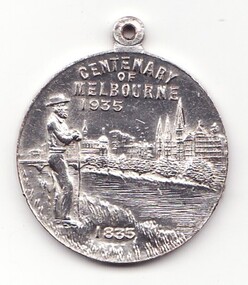 Learmonth and District Historical Society Inc.
Medal - Centenary of Victoria, Centenary of Melbourne 1935
White metal medal issued to commemorate Melbourne's centenary 1934-35. This medal was given out to Victorian school children; 325,600 white metal medals were struck. There were also a few VIP pieces in other metals, including two in gold. The medal references Portland, the location of Victoria's first settlement. The Henty brothers, entrepreneur farmers and whalers, established the state's first permanent European settlement in Portland in 1834. Melbourne was established the following year by a party of settlers led by John Batman. In 1934, as Melbourne planned to celebrate the centenary of European settlement, it seemed to some that there was little to celebrate. The financial strains of the depression, unemployment and the scandal of the city's slums all undercut claims of unbridled progress. Perhaps because of such troubles, the organisers of the centenary celebrations tried doubly hard to be positive. The themes of the celebrations were conservative, reflecting the desire of some Melburnians for security in troubled times. The widely promoted image of the 'Garden City' and 'Queen City of the South' emphasised the idea of Melbourne as a very British city. A visit by the Duke of Gloucester, son of George V, the ageing king, provided a reassuring strengthening of Melbourne's imperial connections. The presented view of Melbourne's history stressed the 'myth of the pioneer', embodied in the person of John Batman. Elevated to heroic status, he was reinvented as a courageous pioneer whose life exemplified the rewards of self-improvement. Such a portrayal ignored Batman's dubious 'treaty' with local Aborigines and the less savoury details of his personal life. Melbourne's indigenous people were excluded from this triumphant view of Melbourne's past. The centenary celebrations now seem dated, but the image of Melbourne as a conservative city largely influenced by Britain has been more enduring.Details the settlement of Portland, Melbourne and Victoria, 1834 - 1935Double sided round white metal medal, featuring on front face, the bay of Portland showing a ship in the harbour. On the reverse side of the medal is John Bateman overlooking the city of Melbourne and the Yarra river.The front is inscribed, "CENTENARY OF VICTORIA" 1934, across the top, bottom right has the words "PORTLAND 1834". Reverse side shows "CENTENARY OF MELBOURNE 1935", and the date 1835 at the bottom. melbourne, medal, portland, centenary of victoria 1935 -
 Federation University Historical Collection
Photograph, Clare Gervasoni, Norfolk Island Pine in the Ballarat School of Mines Gardens, 23/04/2020
... Norfolk Island Pine in the Ballarat School of Mines Gardens ...The Ballarat School of Mines Botanical Gardens were established in 1879, and are situated at the rear of the current administration building. The gardens enabled the students to sit for examinations for registration by the Pharmacy Board of Victoria. An important aspect of this course was the study of Materia Medica, or botanical materials used for medicinal purposes.Colour photograph of a norfolk island pine in the botanical garden sat the back of the Ballarat School of Mines Administration Building.smb botanical gardens, botanical gardens, smb, ballarat school of mines, school of mines ballarat, ballarat, photograph, norfolk island pine, alfred mica smith -
 Federation University Historical Collection
Photograph - Photograph - Black and White, Silver Birch in the Ballarat School of Mines Gardens
... Silver Birch in the Ballarat School of Mines Gardens ...The Ballarat School of Mines Botanical Gardens were established in 1879, and are situated at the rear of the current administration building. The gardens enabled the students to sit for examinations for registration by the Pharmacy Board of Victoria. An important aspect of this course was the study of Materia Medica, or botanical materials used for medicinal purposes.Black and white photograph of the garden at the back of the Ballarat School of Mines Administration Building. In central position is a Silver Birch.smb botanical gardens, botanical gardens, smb, ballarat school of mines, school of mines ballarat, ballarat, photograph -
 Kew Historical Society Inc
Plan, Melbourne & Metropolitan Board of Works : Borough of Kew : Detail Plan No.1296, 1904
The Melbourne and Metropolitan Board of Works (MMBW) plans were produced from the 1890s to the 1950s. They were crucial to the design and development of Melbourne's sewerage and drainage system. The plans, at a scale of 40 feet to 1 inch (1:480), provide a detailed historical record of Melbourne streetscapes and environmental features. Each plan covers one or two street blocks (roughly six streets), showing details of buildings, including garden layouts and ownership boundaries, and features such as laneways, drains, bridges, parks, municipal boundaries and other prominent landmarks as they existed at the time each plan was produced. (Source: State Library of Victoria)This plan forms part of a large group of MMBW plans and maps that was donated to the Society by the Mr Poulter, City Engineer of the City of Kew in 1989. Within this collection, thirty-five hand-coloured plans, backed with linen, are of statewide significance as they include annotations that provide details of construction materials used in buildings in the first decade of the 20th century as well as additional information about land ownership and usage. The copies in the Public Record Office Victoria and the State Library of Victoria are monochrome versions which do not denote building materials so that the maps in this collection are invaluable and unique tools for researchers and heritage consultants. A number of the plans are not held in the collection of the State Library of Victoria so they have the additional attribute of rarity.Original survey plan, issued by the MMBW to a contractor with responsibility for constructing sewers in the area identified on the plan within the Borough of Kew. The plan was at some stage hand-coloured, possibly by the contractor, but more likely by officers working in the Engineering Department of the Borough and later Town, then City of Kew. The hand-coloured sections of buildings on the plan were used to denote masonry or brick constructions (pink), weatherboard constructions (yellow), and public buildings (grey). This area was once known as O’Shaughnessy’s Paddock. O’Shaughnessy was the licensee of the Kew Hotel. The ‘Paddock’ or farm was for many years the closest farm to Melbourne. By 1903, when this plan was surveyed and lithographed, little of the farm remained. The area is dominated by a ‘clay hole’, on the site of the current Foley Reserve. It was used by Smart’s Brickyard from the 1880s until 1911, when the Council purchased it for a rubbish dump. It is notable as the site is one of the few industrial operations to have existed in Kew. By 1903, urban development was characterised by larger houses fronting Barkers Road and brick and weatherboard villas in Foley Street. Nearer the pit, weatherboard houses predominated. Foley Street bisected the triangular block and continued right to Denmark Street. At this stage, a house impeded the through road, only allowing access via a right of way to High Street.melbourne and metropolitan board of works, detail plans, mmbw 1296, cartography -
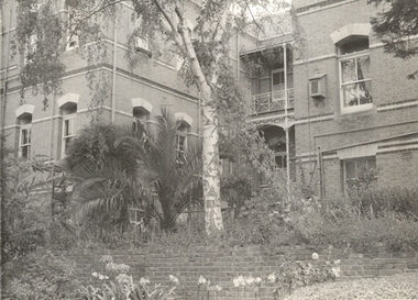
 Federation University Historical Collection
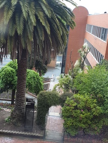
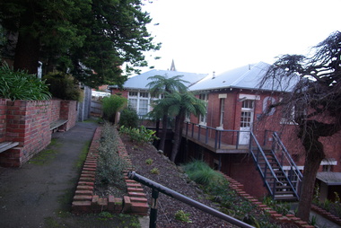
Photograph - Colour Photograph, Ballarat School of Mines Botanical Gardens, 13/08/2020
... Ballarat School of Mines Botanical Gardens ...The Ballarat School of Mines Botanical Garden was established in 1870, and was used by students of Materia Medica and Botany.Photograph of the Ballarat School of Mines Botanical Gardens showing stairs leading to a brick building (Administration Building). ballarat school of mines botanical gardens, ballarat school of mines, materia medica, system garden -
 Kew Historical Society Inc
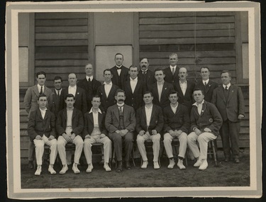
Photograph, 1st X1, Hawthorn East Melbourne Cricket Club, c. 1927
The East Melbourne Cricket Ground was a grass oval sports venue located at the corner of Wellington Parade and Jolimont Parade, in East Melbourne, Victoria, Australia. After the 1921 football season, the ground was closed and then demolished to make way for an extension of the Jolimont Yard railway sidings. In 1921, East Melbourne Cricket Club merged with the Hawthorn Cricket Club, following the loss of the former's ground, to become known as Hawthorn-East Melbourne (or the "Combine"). In 1989, after the club relocated to Glen Waverley, it dropped "East Melbourne" from its title until becoming Hawthorn-Waverley in 1994.Team photo of the Hawthorn East Melbourne Cricket Club, from the collection made by one of its players, Christopher Robinson, pictured middle row, 4th from right. The photo was probably taken at the Glenferrie Oval where the team played. The Club were First Grade Premiers in 1927-28hawthorn east melbourne cricket club, glenferrie oval, cricket, sport, christopher robinson -
 University of Melbourne, Burnley Campus Archives
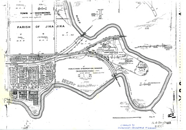
Plan, Allan & Tuxen et al, Public Park & Recreation Reserve (Richmond Park), 1886-1996
Shows changes in ownership of various parts of Richmond Park and Burnley Gardens including University of Melbourne, Amrad, Melbourne City Link, etc. from gazettal in 1873 to 1996Photocopy of plan of Richmond Park and Burnley Gardens with University of Melbourne land acquisition 13.10.1994 hand drawn on it, dates Act revoked and Gazette numbers. Based on plan of Parish of Jika Jika R 19 (3)"Changes to ownership & boundaries of Gardens" in inkpublic parks, recreation reserve, richmond, parish if jika jika, burnley gardens, horticultural society of victoria -
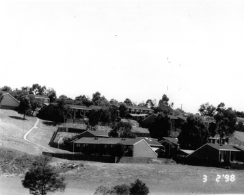 Broadmeadows Historical Society & Museum
Photograph, Banksia Gardens Estate 1998, 3 February 1998
... Banksia Gardens Estate 1998 ...This photograph from 1998 captures the Banksia Gardens Estate in Broadmeadows, a significant public housing development of the time. The image provides valuable insight into the architectural design and living conditions within the estate during the late 1990s. Banksia Gardens was established to offer affordable and accessible housing, reflecting the social and economic priorities of the era. The estate served as a crucial community hub, fostering social connections and providing essential support to its residents. This photograph stands as a historical record of the efforts made to create stable and inclusive communities through public housing initiatives.This photograph of the Banksia Gardens Estate in Broadmeadows, taken in 1998, holds significant historical value. As a public housing estate, Banksia Gardens played a crucial role in providing affordable and accessible housing to the community. The image captures the essence of the estate's development during that period, reflecting the social and economic priorities of the late 1990s. Banksia Gardens served as a vital community hub, fostering social connections, providing essential support, and enhancing the quality of life for its residents. This photograph stands as a testament to the importance of public housing in creating stable and inclusive communities.Black and white photograph on glossy paper.Public Housing Estate/Banksia Gardens 1998/(Upside down bottom left corner) 28banksia gardens estate, broadmeadows, 1998 -
 Melbourne Tram Museum
Book, Melbourne & Metropolitan Tramways Board (MMTB), "Melbourne and Metropolitan Tramways Board / Curriculum of Training for Bus Drivers", 1955
Provides the training program for Melbourne bus drivers, including application and approval process, driving tests, follow ups, records, training procedures and syllabus of training.Yields information about the training of MMTB Bus drivers.Fifty Six page book bound within heavy green Rexene covers, single section, titled "Melbourne and Metropolitan Tramways Board / Curriculum of Training for Bus Drivers" and dated 1955. Two copies held.Has "19" in red ink on inside title pagetrams, tramways, mmtb, personnel, procedures, instructions, buses -
Stawell Historical Society Inc
Photograph, Elsie M Dicker, Ex Stawellites at Fitzroy Gardens c1940's
... Ex Stawellites at Fitzroy Gardens c1940's ...gathering of Ex Stawellites at Fitzroy Gardens 26th JanuaryFour Panoramic photographs of Ex Stawellites at Fitzroy Gardens. One dated 1943. one 1948 and two dated 1940'sSent by E.M. Dicker 170 Auburn Rd Auburncelebrations -
University of Melbourne, Burnley Campus Archives
Article, Claire Pitts, Burnley Gardens - an experimental success, 1990
... Burnley Gardens - an experimental success ...Photocopy of article in Garden Journal. Advertisement for Centenary Celebrations at end. Claire Pitts, author, focuses on some of the very diverse areas within the gardens that tare the horticultural centre of Victoria and describes how they have been modified over time. Article by Claire Pitts, Australian Garden Journal, Vol.10, No. 2, Dec,1990/Jan.1991 - Another copy at B94.813claire pitts, australian garden journal, burnley centenary, burnley gardens centenary celebrations, burnley gardens 100 year anniversary, burnley gardens over time -
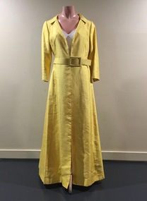 Kew Historical Society Inc
Clothing - Yellow Silk Evening Coat, 1960s
Jinoel of Melbourne was a highly successful Australian fashion house launched by Jill and Noel Kemmelfield in 1957. Eleven years later the designers won the [Melbourne] Gown of the Year award. Jill and Noel Kemmelfield were later to launch Marty and Martine, their mid-market labels. They closed their business in the 1980s. The evening coat was owned, worn and donated by Dione McIntyre.The McIntyre Collection of clothing and clothing accessories forms one of the largest single donations to our Fashion & Design collection. It includes clothing and clothing accessories worn by four women in the Cohen and McIntyre families across three generations. The items worn by Melbourne architect, and Kew resident, Dione McIntyre date from the 1960s and 1970s, and include evening wear, day wear, hats and shoes. As Dione McIntyre often accompanied her husband, fellow architect Peter McIntyre, to formal events, there are a number of pieces of evening wear among the items. The McIntyre Collection also includes items worn by women of an earlier generation: by Lilian Cohen, Dione McIntyre's mother, and by her mother-in-law, the wife of the architect Robert McIntyre. At the other end of the chronological spectrum are a number of outfits belonging to, worn and donated by Annie McIntyre. These include outfits created by notable late 20th century Australian and/or international fashion designers. The McIntyre Collection is significant historically and artistically as it includes examples of design that demonstrate changing tastes in fashion over an 80-year period. The collection is also significant in that it includes the work of a large number of Melbourne designers from the 1960s to the 1990s. Long sleeved full length yellow raw silk evening coat fastened with a belt of the same colour and fabric. Designed by Jinoel of MelbourneLabel: Jinoel of Melbournewomen's clothing, jinoel of melbourne (vic), coat dresses, jill & noel kemmelfield, mcintyre collection, australian fashion - 1960s -
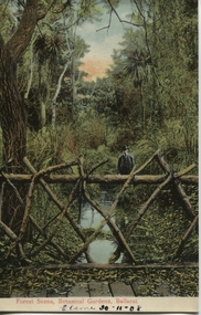 Ballarat Heritage Services
Postcard, Ballarat Botanical Gardens, c1908
... Ballarat Botanical Gardens ..."Within six years of its first land sales in 1852, founder members had challenged council over horticultural decisions and Ballarat's main thoroughfare contained fences squares, trees and flower beds. The major works that projected the Garden City image were the street plantings, parks and botanical gardens ..." Reference: Michael Taffe, Growing a garden City: Ballarat Horticultural Society 1859-2009, BHS Publishing, 2014, p. 10.This postcard shows how the botanical gardens in Ballarat, famous for being a Garden City.Coloured postcard Forest Scene, Botanical Gardens, Ballarat printed in red at bottom of card. Elaine 30-11-08 handwritten in black ink underneath.botanical gardens, ballarat, forest scene, gardens, botanical,