Showing 345 items matching "mining geology"
-
 Rutherglen Historical Society
Map, 1908
This is a map produced as part of a book entitled.. It is also stamped on the back in blue ink with an oval ring and the words North of England Institute. Newcastle. Mining & Meterolgical Faculty. Purchased on 23rd July 2017 by the Society after research by member Simon Killeen. Mining map of one of the first mines in Rutherglen area ( Chiltern West)Cream paper, black printing, rectangle with a drawingGeographical Survey of Victoria, Memoir, No6. Plate XX Plan of Underground Workings CHILTERN VALLEY CONSOLS MINE, RUTHERGLEN, PARISH OF CHILTERN WESTgold, rutherglen, mining, chiltern, underground mine map, geological survey, reef drives -
 Ballarat Heritage Services
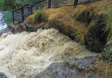
Photograph - Digital photographs, L.J. Gervasoni, Hepburn Blowhole blowing, c2004
... park mining blowhole floods weather geology Water flowing ...Water flowing through the tunnel at The Blowhole, Hepburnhepburn, landscape, heritage, hepburn regional park, mining, blowhole, floods, weather, geology -
 Bendigo Historical Society Inc.
Document - REEFS AND SPURS ON BENDIGO GOLDFIELD
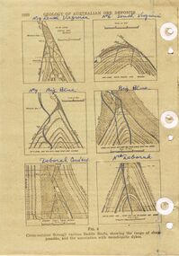
Three pages of information (copied ) regarding reefs and spurs on Bendigo Goldfield. Page 1020 'Geology of Australian ore deposits', drawings labelled in blue biro: No 19 level Virginia Mine, No 6 level South Virginia; No 9 level, Big blue, Big Blue, Deborah Cons'ted ( consolidated?) North Deborah. On bottom ' cross sections through various saddle reefs, showing the range of shape possible, and the association with monchiquite dykes' Page 1021 ( cont) Virginia South Extended; 3000ft New Chum Rly; Catherine Reef, Spurs in Carlisle. On bottom ' Cross sections through a trough reef, 'double' saddle reef and spurry systems. Final page: mines listed and descriptions of workings: Golden Age, Johnson's Reef Extended, Golden Pyke, Constellation, Great Northern, Virginia, Specimen Hill United, New Argus, Clarence United, North Argus, South New Moon.bendigo, mining, reefs and spurs -
 Bendigo Historical Society Inc.
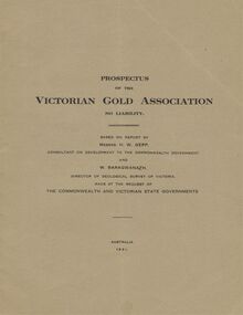
Document - MCCOLL, RANKIN AND STANISTREET COLLECTION: VICTORIAN GOLD ASSOCIATION, 1931
Prospectus of the Victorian Gold Association N.L. Based on a report by Messrs H. W. Gepp Consultant on Development to the Commonwealth Government and W. Baragwanath, Director of the Geological Survey of Victoria. Dated 1931 This company was formed to investigate the Deborah Mine, The Central Nell Gwynne Mine and the Monument Hill Mine. 12 pages including maps and Transverse Sections of the MinesThe Commonwealth and Victorian State Governments. E. Whitehead & Co., Pty., Ltd Printers 21 Equitale Place, Melbourne, C1.gold, mining, prospectus, bendigo, gold mines, victorian gold associatian, deborah mine, central nell gwynne mine, monument hill mine. -
 Bendigo Historical Society Inc.
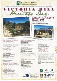
Document - VICTORIA HILL MARONG RD BENDIGO HERITAGE DAY BROCHURE 2010, 2010
Victoria Hill Marong Rd Bendigo (Opposite the Gold Mines Hotel) Heritage Day Brochure 2010. Victoria Hill Guided Tours James Lerk (Bendigo Historical Society) George Ellis (Bendigo Cornish Association) Rod Orr (Bendigo Field Naturalists Club) David Bannear (Heritage Victoria) Presentations: Rod Fraser The Geology of Victoria Hill and Bendigo, Kurt Walder German Heritage Ballerstedts-miners from the Hartz Mountains crushing battery, Rod Orr Mining and the Environment in Bendigo, Michele Matthews (BRAC) Sir John Quick the Forgotten Father of Federation spent his youth in the shadow of Victoria Hill, David Bannear ''Things Forgotten'' - the Archaelogy of Bendigo, Carol Holsworth the Chinese and Victoria Hill area, John Kelly Inquests held at the Gold Mines Hotel, George Ellis The Cornish miners of the Ironbark and Long Gully area, Amanda Jean The Ironbark Heritage Study. Coath Cottage Open Day owner Andrew Ward and Restorer Gary Hill explain the history and restoration of the 1860s miners cottage after Black Saturday fire. Restoration Loans from the City of Greater Bendigo.bendigo, gold mining, heritage day 2010 -
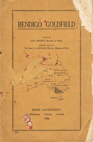 Bendigo Historical Society Inc.
Book - JOAN O'SHEA COLLECTION: BENDIGO GOLDFIELD BOOK, 1936
Joan O'Shea collection. Buff coloured book issued by Mines Department Melbourne. Victoria Australia 1936. Information contained within refers to History, Recent developments and future Prospects, Geology, Lines of Reef for the Bendigo area, information regarding tonnage of gold and values of same at that time. The index at the rear of the book lists all of the mines in the Bendigo area.Geo. Brown, Secretary for Mines, Mines Departmentmining, business, mines department -
 Bendigo Historical Society Inc.
Document - PETER ELLIS COLLECTION: NOTES WRITTEN BY PETER ELLIS
Some brief research? Notes written by Peter Ellis from the years 1881 to 1899. Mentioned is the Bendigo School of Mines Science Society and some of its meetings and the number of people who attended. Also mentioned are: The animal of Australia by Dr. MacGillivray; a paper on graptolite by Mr T L Hall, M.A., Director of Castlemaine School of Mines; Annual Report June 30 1888, Spiders, ? & Marsupials (MacGillivray/Rev Williams; Nancarrow - Slides & Cross Courses - Geological quartz of Goldfield; 27/1/1887 Meetings held during the year - some were well attended, some were not; On the 31 May the President (MacGillivray) spoke at some length on the Requirement of a Local Museum; Annual report 1900; Mining Society formed 1899 and Scientific Conversation lecturettes on Chemistry & Electricity.bendigo, history, early bendigo, peter ellis collection, the a-- of australia, dr macgillivray, t l hall ma, castlemaine school of mines, bendigo school of mines science society, rev williams, nancarrow, sandhurst district, requirements of a local museum, melb public library -
 Bendigo Historical Society Inc.
Photograph - Aerial shots of parts of Bendigo 1934, 1934
AERIAL SHOTS OF PARTS OF BENDIGO 1934 Catalogue No.10584 This document contains scans of a unique set of aerial photographs that were taken over the City of Bendigo on Friday 12th January 1934, at about midday. The photographs were commissioned by Bendigo Mines Limited during their exploration and mining program designed to revitalize the Bendigo Goldfield. The photographs were given to the Victorian Mines Department sometime in the 1950s. The photographs were taken at a relatively low level of about 4000 feet. This gives a very detailed picture of Bendigo as it was in the 1930s. The photos cover the City Centre and are mainly of the goldfields on the south side of the city; the extent of which covers approximately the four corners of Myers Flat, Maiden Gully, Mandurang and One Tree Hill. Streets, roads and places of interest have been identified as best as possible in December 2023. There are 44 maps, and each references the adjoining maps.Typed Notes with CD The CD is one of two and contains a set of 46 images: The folder named "High_Resolution_800dpi" contains the original digital files that were produced by scanning the photographic prints (About A3 size) at 800 dpi using a high quality, large pformat, roll scanner. These files may be too large for some computers. A second CD contains a direstory called "Low_Resolution_300dep" The images in the folder names "Low_Reolution_300dpr" have a lower resolution (300 dpi) and have been rotated 90 degrees clockwise so that the Northern margin of each image is a the top of the screen. Clive Willman Senior Geologist Geological Survey of Victoriahistory, bendigo, bendigo mines, bendigo maps, bendigo aerial photos -
 Bendigo Historical Society Inc.
Document - KANGAROO FLAT GOLD MINE COLLECTION: MEMO TO SANDNER FROM WILLMAN
Two page memo 17 January 1984, to R. Sandner, D. Cahill, R. Cameron, P.Vail and D. Andrew from C.E. William. Topics covered: Deborah lease project; Brunswick Mine Costerfield, E.L's 1397 and 1398; town planning permit application; historical research and geological assessment, dewatering programme.bendigo, gold mining, deborah lease project -
Stawell Historical Society Inc
Archive, Geological Survey of Victoria 1903 Brown Cover, 1903
... grampians Stawell Mining 1903 Brown Cover Geological Survey ...1903 Brown Coverstawell, mining -
Stawell Historical Society Inc
Map, Victorian Geological Map, 1963
... grampians Stawell Mining Victorian Geological Map Victorian ...Victorian Geological Mapstawell, mining -
 Federation University Art Collection
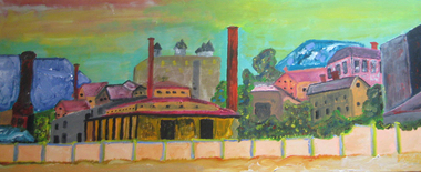
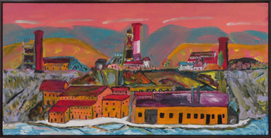
Painting - Artwork - Painting, 'School of Mines New Beginnings part a & b' by John Collier, 2008
John COLLIER (1937- 2012) John Collier was born at Ballarat in 1937. He received a Diploma of Mining and a Diploma of Civil Engineering at the Ballarat School of Mines (SMB), later graduating from the University of Melbourne with a Bachelor of Engineering (Mining). Early in his career he received a Diploma of Accountancy from the Australian Society of Accountants. Collier believes his experience at SMB had a profound influence on his life, especially what he learnt in Geology, Engineering, Chemistry, etc., all of which he found beneficial to his later working life and he is proud of that association. Through his experience in the world-wide mining industry John Collier has made a major impact on the mining industry. He has been exploration leader for a large number of worldwide discoveries and farm-ins both major and minor. He has experience in every facet of the mining industry, and his record in identifying diamond opportunities include Australian (Argyle), Canada (Diabik), Zimbabwe, and the Brazil Pipe (Collier Falls). His success in diamond exploration may be unparalleled. John Collier also has significant success with lead-zinc, iron ore, coal, copper, gold-silver, petroleum, heavy minerals, nickel, uranium, industrial minerals, rare earths, and tin. In 2006 John Collier was made a Legend in Mining by the Australian Mining Industry. Over his last 10 years, he had become a passionate painter, holding several successful solo exhibitions. His naive style featured beautiful and unexpected colour combinations. Many of his most lauded paintings depicted mining scenes, harking back to his Ballarat days. This item is part of the Federation University Art Collection. The Art Collection features over 2000 works and was listed as a 'Ballarat Treasure' in 2007.Two artworks by John Collier inspired by his alma mater, the Ballarat School of Mines. art, artwork, john collier, ballarat school of mines, alumni -
 Federation University Art Collection
Painting - acrylic on canvas, Collier, John, 'Port Phillip Colonial GMC, Clunes' by John Collier, 2008
John COLLIER (1937- 2012) John Collier was born at Ballarat in 1937. He received a Diploma of Mining and a Diploma of Civil Engineering at the Ballarat School of Mines (SMB), later graduating from the University of Melbourne with a Bachelor of Engineering (Mining). Early in his career he received a Diploma of Accountancy from the Australian Society of Accountants. Collier believes his experience at SMB had a profound influence on his life, especially what he learnt in Geology, Engineering, Chemistry, etc., all of which he found beneficial to his later working life and he is proud of that association. Through his experience in the world-wide mining industry John Collier has made a major impact on the mining industry. He has been exploration leader for a large number of worldwide discoveries and farm-ins both major and minor. He has experience in every facet of the mining industry, and his record in identifying diamond opportunities include Australian (Argyle), Canada (Diabik), Zimbabwe, and the Brazil Pipe (Collier Falls). His success in diamond exploration may be unparalleled. John Collier also has significant success with lead-zinc, iron ore, coal, copper, gold-silver, petroleum, heavy minerals, nickel, uranium, industrial minerals, rare earths, and tin. In 2006 John Collier was made a Legend in Mining by the Australian Mining Industry. Over his last 10 years, he had become a passionate painter, holding several successful solo exhibitions. His naive style featured beautiful and unexpected colour combinations. Many of his most lauded paintings depicted mining scenes, harking back to his Ballarat days. This work and subject matter was painted for the artist's alma mater, the Ballarat School of Mines (now Federation University Australia). This item is part of the Federation University Art Collection. The Art Collection features over 2000 works and was listed as a 'Ballarat Treasure' in 2007.Colourful acrylic on canvas painting depicting the Port Phillip Gold Mining Company, Clunes.art, artwork, john collier, port phillip cold mine, clunes, clunes, available, alumni, mining -
Tarnagulla History Archive
Set of Maps (Mining & Local Area), various
David Gordon Collection. A set of mining documents, maps and plans: 1. Dunolly Deep Leads - showing location and names of deep lead gold deposits in region around Dunolly including at Tarnagulla and Newbridge. Geological Survey of Victoria, Department of Minerals and Energy. Bulletin No. 62, Map No. 4 Dunolly (770 x 485 mm). 2. Poseidon Lead (Facsimile) 3. Nick O Time Lead (Facsimile) 4. Happy Go Lucky Mine prospectus and plan (colour copy) 5. Jones Creek GM Co. (Raven & Gourlay's) Waanyarra - Prospectus (colour copy) 6. Poseidon Area Plan (colour copy) and Poseidon Area map (B&W copy). 7. Cross-section diagram of Spread Eagle Reef 8. New Birthday Gold Mine - area map (colour copy) and mine cross-section ( (colour copy). 9. Cross section of Poverty Reef, by Department of Mines (B&W copy, 2 parts on A2 paper) 10. Time-Lease Graph for Watts Reef, Specimen Reef, Stony Reef, Poverty Reef (second page in detail), created by Eric WIlkinson for Ref Mining NL, 1995 11. 1859 Plan of the Gold Workings & Township of Sandy Creek, Shewing the Mining Leases, Extended Claims & Machinery by R.J. McMillan, Mining Surveyor (B&W copy) 12. Longitundinal and Transverse Vertical Sections of Poverty Reef, Sandy Creek 1859, by R.J. McMillan, Mining Surveyor (B&W copy) 13. Tarnagulla Locality Plan (B&W copy) 14. Universal Grid Reference Map (Topographic) for Laanecoorie North (2 copies) 15. Universal Grid Reference Map (Topographic) for Inglewood South 16. Poverty Reef, Plan showing shafts and early tenements, created by Eric WIlkinson for Ref Mining NL, 1995 17. Locality Map of mining leases in Tarnagulla 18. Plan and Elevation of part of Poverty Reef, Sandy Creek, showing the claims and positions of the shaft. by R.J. McMillan, Mining Surveyor (Facsimile, composed of taped together components) 19.Plan and Elevation of part of Poverty Reef, Sandy Creek, showing the claims and positions of the shaft. by R.J. McMillan, Mining Surveyor (Facsimile, composed of taped together components) -
Tarnagulla History Archive
Photocopy of booklet: List of Nuggets Found in Victoria, List of Nuggets Found in Victoria, 1912 (original)
Murray Comrie Collection. Photocopy of the publication 'List of Nuggets Found in Victoria ' being No. 12 in the Memoirs of the Geological Society of Victoria.tarnagulla, nuggets, gold, mining, prospecting -
Bendigo Historical Society Inc.
Map - STRUGNELL COLLECTION: BENDIGO GOLD FIELD GEOLOGICAL SURVEY, 1936
... BHS Collection BENDIGO Gold mining geological map Dept ...BHS CollectionBendigo Goldfieds Geological Survey. Prepared in the Bendigo Office Bottom Section of original map.Dept of Mines Victoriabendigo, gold mining, geological map -
 Federation University Historical Collection
Map, Ballarat Goldfield, c1898
This map shows geological features, suggests the last basalt flow, and includes alotments and names of Mining Companies. Although this map has no date on it the Ballarat Industrial School is used for dating purposed. The Ballarat Industrial School ran from 1869-1879, but the term Ballarat Industrial School Reserve was still in use in 1898 and possibly beyond.Geological Map of Ballarat with 3 holes in the left hand side. The map indicates the position of Lake Wendouree, Township of Warrenheip, Ballarat East, Industrial School Reserve, Winters Swamp, Police Paddock, Wyndholm Premptive Right (Salton and Waldie), Black Hill, Vale Park Reserve, Pennyweight Hill, Little Bendigo, Black Swamp Lead, monte Christo Reef, Chinaman's Gully, Miners Rest, Pincotts Dam, Northumberland Gully. It also show the following goldmining companies: City of Ballarat, Kohinor, Hand and Band, Great North West, Northern Junction, Kneeshaw, Rossers Freehold, Silurial.ballarat, warrenheip, lake wendouree, ballarat east, winters swamp, winter swamp, wyndholm premptive right, cemetery, vale park reserve, little bendigo, kneeshaw co., industrial school reserve, kirks dam, pincotts dam, black hill, wombat hill, dead horse gully, miners rest, mt rowan, salton and waldie, rose hill co, great north west no 1, rose's freehold co, hand and band co, police reserve, police paddock, mount rowan, ballarat industrial school reserve, market reserve, winter's swamp, kneeshar co, monte cristo line of reef, chinaman's gully or black snake, milkmaid's gully, ballarat gold field, bakery hil lead, old gravel pits lead, golden point lead, eureka lead, miner's rest, yarrowee creek, leigh creek, black swamp lead, yorkshire reef, nil desperandum reef, cockatoo lead, hit or miss gully, herbert werner frederick de nully, pennyweight hill, esmond's lead, ash's lead, nightingale lead, john bull gully, gladstone reef, whitehorse reef, petticoat creek, pincott's dam, frenchman's gully, tim's crushing plant, jenkin's gully, california gully, drake's creek, sulton and waldie, ballarat undustrial school, ballarat & mariborough railway -
 Federation University Historical Collection
Map - Geological Survey, J. Phillips, Geological Survey of Victoria - Ballarat, 1857, 10/1858
Geological map of the Ballarat District featuring four colours.ballarat, geological, geology, geological plan, main road, camp, golden point, pennyweight hill, clayton hill, ballaarat cemetery, bakery hill, specimen hill, soldiers hill, nightingale lead, native youth black hill flat, white flat, mining, mines, eureka lead, old post office hill -
Federation University Historical Collection
Map - Map - Geological, Geological Survey of Victoria - Ballarat, 09/1858
Coloured Geological Map of Ballarat, edged with masking tape. The map show alluvial silt, gold drift, geological orders, volcanic, and gold workings. Scale is 8 chains to an inch. WGS 84 Centroid: 37 degrees 33 feet 33 inches south 143 degrees 52 feet 02 inches east W.E. extent: 5km NS extent: 3 kmballarat, ballaarat, geology, goldfield, phillips, j. phillips, mining, alfred selwyn, ferguson and mitchell -
 Bendigo Historical Society Inc.
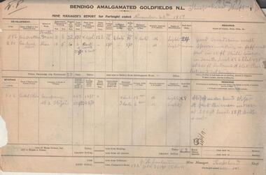
Administrative record - Bendigo Amalgamated Goldfields N.L. Mine Manager's Reports, 1917 - 1920
In 1917 Bendigo Amalgamated Goldfield Ltd was formed from the amalgamation of 35 companies with operations on the Garden Gully, Sheepshead, Deborah and Derby lines of reef hoping to increase profits of these existing operations through economies of scale. This was difficult to achieve as the shafts involved were spread throughout the goldfield. Diamond drilling and good geological practices were introduced (Pabst was Chief Geologist) leading to some exploration success. However costs were rising rapidly and in 1923 the directors, deciding that mining would soon become unprofitable, dissolved the company returning assets to the original vendors. J.H. Lenten, Mine Manager, received his second class Mine Manager's certificate in September, 1914 at an examination held at the Bendigo Law Courts. One hundred pages of fortnightly manager's reports for Bendigo Amalgamated Goldfields N.L., Sheepshead Shaft. Reports consist of two pages for each fortnight, signed by J.H. Lenten, Mine Manager. Dates of reports range from November 20th, 1917 to 5th May 1920. Categories reported on include: development, stoping, tons from tributors, tons Company's stone, plant and machinery, underground workings, number of rock drill shifts, firewood used, coal burnt, and general remarks. charcoal burnt., lifting waterbendigo, margaret roberts, , goldmining, bendigo amalgamated goldfields, sheepshead shaft, j.h. lenten, mine manager -
 Eltham District Historical Society Inc
Book, Jenny Brown et al, Out of the Mist; Osborne Peninsula, 2024
The Osborne Peninsula on the Yarra River at Warrandyte accommodates a limited number of properties and residents (70 households). The area is rich in geology and ecology, and an unusually rich endowment of human, built and creative history. Contents: Welcome: The landform: The River: Aboriginal occupation: The Miners: North Warrandyte :The Subdivision: The Lowes: The Osbornes: The Last Osborne: The Elders: The Relics: Dray Track: Water Wheel"Kauri Plaque: River track: Pines: Windmill Creek Bridge: The Koornong School: The Houses" Man Cave: MidCentury Classic: Enduring Original" Masterwork: The Muddies: The State Park: The Saving of Koornong Reserve: The Landcare Story: Flora and Fauna: The Vulnerable, Endangered and threatened: Birds: Mammals: "Waring" the wombat: Reptiles: Fish: Invertebrates: Flora: Fire. Published by the North Warrandyte (Osborne Peninsula) Landcare Group. Includes photos from EDHS collection.64 p. : ill., map ; 29.7 x 21 cm. (2 copies)yarra river, birrarung, dray track, fauna, geology, houses, indigenous history, koornong reserve, koornong school, lowe family, mining, mudbrick houses, north warrandyte, osborne family, warrandyte state park, water wheel, north warrandyte (osborne peninsula) landcare group, osborne peninsula -
 Stawell Historical Society Inc
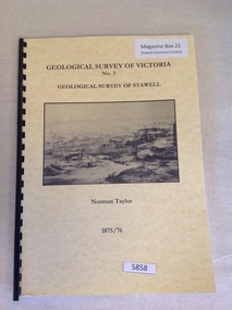
Book, Norman Taylor, Geological Survey of Victoria No3, Geological Survey of Stawell, 1875-1876
... , Geological Surveyor stawell mining Geological Survey of Victoria No.3 ...Geological Survey of Stawell 1875/76 by Norman Taylor, Geological SurveyorYellow Card Front and Rear Cover with B/W Picture of mining scene. with black Plastic spineGeological Survey of Victoria No.3 Geological Survey of Stawell Norman Taylor 1875/76stawell mining -
 The Beechworth Burke Museum
Geological specimen - Fossil Leaves
A fossil refers to any remains or traces of past life that are preserved in the rock. It could be remains of plants or animals. Fossil leaves are commonly found on different types of rocks. These fossils can go as far back as the Triassic Age just like the series of fossil plants collected at Denmark Hill, Ipswich in Queensland. Fossils leaves are formed when dead plants get buried by sediments like mud, sand, or volcanic ash. Often, it gets detached cleanly from stems along a special layer of weak cells, then twigs, and, less commonly, cones of conifers and fruits and seeds of flowering plants. Over time, the leaves or pieces of leaves get buried by more sediments and eventually gets 'lithified' or hardened into a rock. Erosions and mining can cause the rocks to break and reveal the fossils buried in it. Fossilisation frequently takes place at sites in the lowlands where deposits of clay, silt, sand are found. This is usually due to weathering and erosion of rocks. Fossil leaves can provide information about ancient Australia's way of living. It contributes to Victorian biodiversity records and its botanical collections. It also contributes information on the geographical profile of Victoria as fossilisation usually occur at estuaries and deltas of rivers, river flood plains, ponds and lakes. This specimen is part of a larger collection of geological and mineral specimens collected from around Australia (and some parts of the world) and donated to the Burke Museum between 1868-1880. A large percentage of these specimens were collected in Victoria as part of the Geological Survey of Victoria that begun in 1852 (in response to the Gold Rush) to study and map the geology of Victoria. Collecting geological specimens was an important part of mapping and understanding the scientific makeup of the earth. Many of these specimens were sent to research and collecting organisations across Australia, including the Burke Museum, to educate and encourage further study.Piece of light brown rock with fossilised leaves in shades of golden yellow and brown.Existing label: Fossil Leaves / Locality unknown / might be worth checking if this is Glossopteris, a Permian age plant. / C. William 16/4/21 geological specimen, geology, geology collection, burke museum, beechworth, fossil leaves, fossilization, 1868 geological survey of victoria, lithified, rocks, fossilised leaf, rock, fossils, leaves -
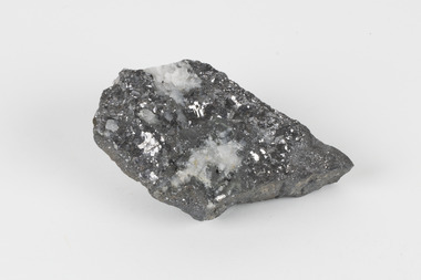
 The Beechworth Burke Museum
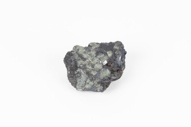
Geological specimen - Garnet (red crystals) in galena (silvery metallic) and green feldspar, Unknown
Garnet is a popular gemstone used in jewellery due to its hardness and durability. There are about 5 varieties of Garnet, which distinguish the colour of each stone. In Australia mostly Pyrope and Aimandine varieties are found; Pyrope, which is blood-red to black and Aimadine, which is brownish-red to black. Other varieties are rarely found in Australia. The garnets visible in this specimen are likely Pyrope. Galnea is the natural mineral form of lead sulphide and has had various uses throughout history; from makeup to car batteries. It was first mined in South Australia in 1841. Green feldspar is an amazonite mineral, a variety of the potassium feldspar called microcline. This particular mineral is considered uncommon. It has been used in jewellery throughout history. It is likely that this specimen was found in Broken Hill, NSW, presumed due to findings of specimens with similar combinations. Broken Hill is Australia’s longest-lived mining city. The city’s fortunes have come and gone against an extreme economic background of boom and bust which continues today.This geological specimen is a rarity, given that is formed of three distinct minerals and the richness of colour that remains visible in this item attests to the strength of each structure. As we cannot pinpoint exactly where this specimen was found further research can only strengthen what is known about mining within Australia. As such the item is significant due to its scientific rarity and its ability to represent three specimens in one. A solid palm-sized mineral that features shades of grey, red and green. garnet, galnea, green feldspar, minerals, mining, rare specimen -
 The Beechworth Burke Museum
Geological specimen - Galena (with quartz), unknown
Galena is the natural compound of lead and classed as a sulphide, it crystallises in a cubic pattern and its chemical formula is PbS. Galena is a primary source of both lead and silver. This specimen of Galena comes from Broken Hill. Broken Hill has one of the world’s largest and most significant deposit of ore for the production of lead. Mining of Galena at Broken Hill began with the staking of land by Charles Rasp in 1883. By the following year, in 1884, Rasp and six others had formed Broken Hill Mining Company. Broken Hill Mining Company eventually evolved into BHP group limited and is currently the largest mining company in the world and the largest company in Australia. There is archaeological evidence from artefacts discovered in Turkey that humans have been extracting lead from galena by the process of smelting since at least 6500 BCE. This specimen also has quartz on the top surface which is frequently discovered alongside Galena. This mineral specimen is of historic significance as a sample of Galena extracted from Broken Hill during the 19th century. Mining for Galena in Broken Hill begin in 1883 by Charles Rasp and evolved into the world’s largest mining company – BHP Group Limited. Broken Hill is one of the world’s most significant deposits of ore for the production of lead. This specimen is part of a larger collection of geological and mineral specimens collected from around Australia (and some parts of the world) and donated to the Burke Museum between 1868-1880. A large percentage of these specimens were collected in Victoria as part of the Geological Survey of Victoria that begun in 1852 (in response to the Gold Rush) to study and map the geology of Victoria. Collecting geological specimens was an important part of mapping and understanding the scientific makeup of the earth. Many of these specimens were sent to research and collecting organisations across Australia, including the Burke Museum, to educate and encourage further study.A flat, hand-sized, grey sulphide specimen that is the natural compound of lead with a quartz formation on the top surface. Existing Label: GALENA / (with quartz) / Locality: Broken Hill / N.S.W 120 x 70 x 29geological specimen, geology, geology collection, burke museum, beechworth, galena, galena quartz, quartz, charles rasp, broken hill mining company, bhp group limited, bhp, lead, ore, lead sulphide, sulphide, silver, broken hill -
Bendigo Historical Society Inc.
Map - STRUGNALL COLLECTION: BENDIGO GOLD FIELD GEOLOGICAL SURVEY, 1936
... BHS Collection BENDIGO Gold mining geological map Dept ...BHS CollectionBendigo Goldfieds Geological Survey. Prepared in the Bendigo Office Lower Section of original map. Note with map says other items donated - yet to be catalogued. TO BE FOUNDDept of Mines Victoriabendigo, gold mining, geological map -
Bendigo Historical Society Inc.
Map - STRUGNELL COLLECTION: BENDIGO GOLD FIELD GEOLOGICAL SURVEY, 1936
... BHS Collection BENDIGO Gold mining geological map Dept ...BHS CollectionBendigo Goldfieds Geological Survey. Prepared in the Bendigo Office Top Section of original map.Dept of Mines Victoriabendigo, gold mining, geological map -
 Bendigo Historical Society Inc.
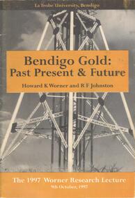
Document - BOOKLET: BENDIGO GOLD: PAST PRESENT & FUTURE - THE 1997 WORNER RESEARCH LECTURE, 1997
BHS CollectionSoftcover booklet produced for the 1997 Worner Research Lecture 9 October 1997. Cover contains black and white photograph of a poppet head, with gold coloured inserts bearing the title, authors and date. 29 pages with the contents of the lecture together with illustrations and photographs. Lecture covered the history and geology and the refractory gold ores.Published by Lat Trobe University Authors Howard K Worner and R F Johnston.bendigo, gold mining -
 Bendigo Historical Society Inc.
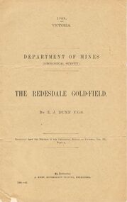
Document - MCCOLL, RANKIN AND STANISTREET COLLECTION: THE REDESDALE GOLDFIELD, 1909
1909 report from the Department of Mines Geological Survey on the Redesdale Goldfield by E. J. Dunn. F.G.S. Reefs mentioned are the Horseshoe Bend Reef, Linda Reef, Bill Smith's workings, the Ben Guy Reef and the Amelia ReefDepartment of Minesgold mining, miners' safety cage, redesdale goldfield, gold mining, redesdale. -
 Federation University Historical Collection
Book, William Harvey Emmons, The Principles of Economic Geology, 1940, 1940
... of Geology and Mineralogy at the University of Minnesota; Director ...The book was used by Charles Bacon who studied at the University of Nevada in the late 1930s/early 1940s. Bacon worked at Bunker Hill Mines and Kellogg Idaho, before arriving in Australian in 1951. He worked for CN Myers, a company involved with paper converting. CN Myers was a family business (on Charles Bacon's maternal line). William Emmons was Professor and head of Geology and Mineralogy at the University of Minnesota; Director of Minnesota geological Survey; and previously Geologist, Section of Metalliferous Deposits, United States Geological Survey.Maroon soft covered book of 529 pages. Chapters include Magmatic Segregations, Pegmatities, Hypothermal Deposits, Sedimentary Depostis, Openings in Rocks, Metasomatic Processes, Mineral Associations and more.Inside front cover "Charles Bacon 1940 Lincoln Hall Ass. University of Nevada Reno, Nevada"charles bacon, mining engineering, metallurgy, university of nevada, mackay school of mines, geology, california