Showing 298 items matching "mining survey"
-
 Bendigo Historical Society Inc.
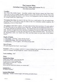
Document - THE LAZARUS MINE - NOTES ON THE THE LAZARUS MINE
One siix page handwritten and three typed copies of notes on the The Lazarus Mine including the Lazarus New Chum and the Lazarus No 1 on the New Chum Line of Reef. Notes include locality, depth of shafts, size of lease, plant, early history, the Lazarus Company, Prominence, Best Gold and Total Gold Yields. Notes prepared by Albert Richardson.document, gold, the lazarus mine, the lazarus mine, notes on the the lazarus mine, lazarus new chum, lazarus no 1, australian headquarters survey unit, george lansell, new chum hill, b c v 8 studios, sheepshead, central red white & blue, mr lazarus, lansell's 222, old chum mine, lazarus company, mr george gibbs, lansell's fortuna, ballerstedt, mr barnet lazarus, the black lead, the white lead, mount alvernia hospital, mines dept special edition 'australian mining standard' 1/6/1899, mines dept booklet 'bendigo goldfield' 1936, mines dept annual and quarterly reports, annals of bendigo mining sections 1868 - 1910, a richardson, the bendigo goldfield registry j n macartney 1/3/1871 -
 Bendigo Historical Society Inc.
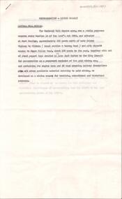
Document - VICTORIA HILL - RECOMMENDATION - MINING PROJECT
Two (a & b) typed copy of a recommendation for mining project, accepted Nov. 1967. Recommendation for Central Nell Gwynne area, now a public purposes reserve for preservation as a permanent reminder of the gold mining era. Victoria Hill Area mentioned for it's geographical and historical significance. The New Chum Hill area rich in historical and mining. Notes on development of the Central Nell Gwynne, Victoria Hill and New or Old Chum Hill areas. Notes prepared by Albert Richardson.mine, gold, victoria hill, victoria hill, recommendation - mining project, central nell gwynne, jack barker, victoria hill area, big 180, victoria quartz, new chum hill (old chum hill), p. m. g. repeater station, mine's department, land's department, lansell, fortuna, a h q survey regiment, lazarus mine, b c v 8 television studio -
 Bendigo Historical Society Inc.
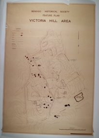
Map - VICTORIA HILL AREA, May 1971
Map: Bendigo Historical Society feature plan. There are 3 of these plans, one is without feature names and one has several places highlighted in pencil. Compiled by AHQ Survey Regiment, CMF Increment ( number 181 in Map Cupboard 1)map, bendigo, mining plan, victoria hill, bendigo historical society, conrad heinze butchers -
 Bendigo Historical Society Inc.
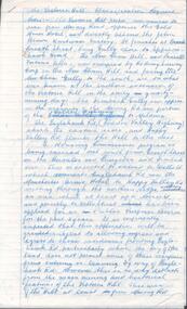
Document - VICTORIA HILL - CLASSIFICATION REQUEST
Handwritten, 3 page carbon copy of a classification request for victoria Hill. Notes give locality, housing program in the area, immediate surrounds of the area, prominent citizens, buildings, mines, geographical formations and gold production. Notes prepared by Albert Richardson.mining, parish map, victoria hill, classification request for victoria hill, gold mines hotel, john brown knitwear factory, lansell's fortuna villa, army survey corp, housing commission, hercules, energetic, ironbark, manchester arms hotel, bendigo goldfield, old miners homes, george lansell, sir george lansell, bendigo advertiser, theodore ballerstedt junior, mr c t c johann ballerstedt, mr wm rae, david sterry, adventure, wittscheibe's 'jewellers shop', luffsman & sterry's rich claim, ballerstedt open cut and mine, lansells 180, victoria quartz, rotary club of bendigo south, bendigo cemetry -
 Bendigo Historical Society Inc.
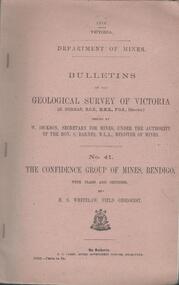
Book - MINING REPORTS - THE CONFIDENCE GROUP OF MINES BULLETIN NO 41
Light brown covered booklet 'Bulletins of the Geological Survey of Victoria issued by W Dickson, Secretary for Mines, Under the Authority of the Hon. S Barnes M L A Minister of Mines. No 41 The Confidence Group of Mines, Bendigo with Plans and Sections by H S Whitelaw, Field Geologist, dated 1918. Mines mentioned are: Confidence Extended Mine, Confidence Tribute Company and the Central Windmill Hill Mine. Mentioned in the report are crushings and gold yield, details of levels, names of leases along the reef. Extracts from Mine Manager's Half-yearly Reports, 1878-1915 of tons crushed and gold yield. Plans and sections of the Confidence Extended Mine on the Garden Gully Line of Reefs are: Plate I General Plan of All Levels, Plans of Levels Plate No II, Plans of Levels Plate No III, Transverse Section Plate No IV, Longitudinal Section Plate No V, and Central Windmill Hill Mine Transverse Section Plate No VI. Plates signed by H S Whitelaw 17 & 18/6/16 and 20/7/16. Booklet if part of the Albert Richardson Collection. book, bendigo, mining reports, mining reports, the confidence group of mines bulletin no 41, confidence extended mine, confidence tribute company, central windmill hill mine, department of mines, bulletins of the geological survey of victoria, w dickson, the hon s barnes, h s whitelaw, h j green, mr robert eddy, mr w h cundy, j foster, c j thompson -
 Bendigo Historical Society Inc.
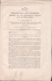
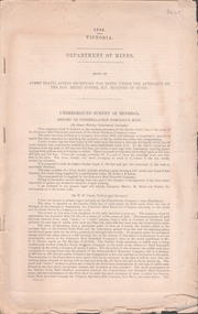
Document - MINING REPORTS - REPORT OF, ON AURIFEROUS DRIFTS AND QUARTZ REEFS
Printed document: Geological Department: Report of, on auriferous Drifts and Quartz Reefs, dated 8th May,1866. Paper describes the gravels and rocks of a Geological Survey. Survey is compared with the lower drifts of Bendigo, Epsom, Ballaarat, Castlemaine and other gold-fields. Four colour sketch-sections included. Document is part of the Albert Richardson Collection. gold, mining reports, mining reports, report of, on auriferous drifts and quartz reefs, mr bindon, alfred r c selwyn, john ferres -
 Bendigo Historical Society Inc.
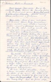
Document - ALBERT RICHARDSON COLLECTION: VICTORIA HILL IRONBARK
Three page document hand written by Albert Richardson, on the history of Victoria Hill, Ironbark. 'one of the richest areas on Bendigo field. In the first six years, £1,200,000 worth of gold was obtained. Almost every claim returned a fortune.' Page three title: Other features on Victoria Hill. 'Adjacent to Central Nell Gwynne area as the mining museum. Adjacent to the New Chum Hill on direct south side of the Calder Highway. This hill reached by a short and excellent access road gives a magnificent view of Bendigo and Golden Square, and a very good view of another tourist attraction, Lansells 'Fortuna' now Survey Regiment's headquarters. This hill is the centre of another rich area. The Lazarus mine 3,360 feet deep with 24 saddle reefs in 2,200 feet. The New Chum United, Lansell's 222with its 120 ft high poppet legs. BCV 8, John Brown Knitwear factory, Esposito's Gold Mines Hotel, Central Nell Gwynne and Manchester tram loops are mentioned.Albert Richardsonbendigo, mining, victoria hill -
 Bendigo Historical Society Inc.
Document - UNDERGROUND SURVEY OF BENDIGO MINES
Two page document, 'Underground survey of Bendigo, report on Constellation Company's Mine on northern extension of the Garden Gully line of reef. Report on the New Chum Railway Reserve Company and the Shenandoah Company, the New Chum Railway Co being immediately south and the Shenandoah Co immediately north of the railway line. Two maps Constellation Co. Mine shaft and New Chum Railway and Shenandoah auriferous reef below 2700 feet.Jems Stirling, geologist and W.H Cundy Underground Surveyor, Department of Minesbendigo, mining, garden gully line of reef mines -
 Stawell Historical Society Inc
Map, Underground Survey of the Principal Mines of Stawell 1879, 1879
... Mining Gold Surveyed by H.C. Bates. Drawn by Arthur Edwards ...Pleasant Creek & Newington, Prince Patrick, Prince Alfred, Pioneer and Galatea, Pleasant Creek Cross Reef No. 1&2, Magdala, Old Shaft, Extended Cross Reef, Crown Cross, Great Northern, Sloanes & Scotchmans, South Cross, 10 & 11 United Scotchmans South Cross, Scotchmans Shafts, North Scothmans, West Scotchmans, Emerald Isle & Rose of Denmark, Albion, South Scotchmans, Newington & Pleasant Creek, Pleasant Creek Cross Reef, Moonlight, Extended Cross Reef, Crown cross United, Great Northern ShaftVery large Map on cloth backing, showing cross sections of mines.Surveyed by H.C. Bates. Drawn by Arthur Edwards. October 30th 1879. Scales 120 feet to an inchmining, gold -
 Bendigo Historical Society Inc.
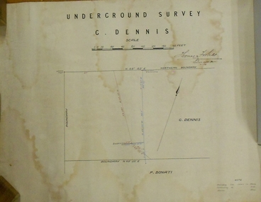
Plan - MARKS COLLECTION: PLAN OF UNDERGROUND SURVEY G. DENNIS MINE
Plan drawn on heavy parchment 'underground survey G. Dennis' printed on top of plan. Plan shows boundary lines and peg site. P. Bonati claim marked on bottom of plan. B. Letter with plan on letterhead 'City of Sandhurst, Town Hall, July 2nd. 1873' Addressed to Mr. George Dennis, Sir, In reply to your letter of the 19th. ulto I am empowered to state that subject to the formation of the road referred to, your existing rights are conserved, and the council will undertake not to object to the renewal of your lease. The only conditions being that you shall not sink a shaft in the street or attempt to obstruct it when formed. I have the honor to be, Sir, your obedient servant, Geo Fletcher, Town Clerk.bendigo, mining, g. dennis claim -
 Bendigo Historical Society Inc.
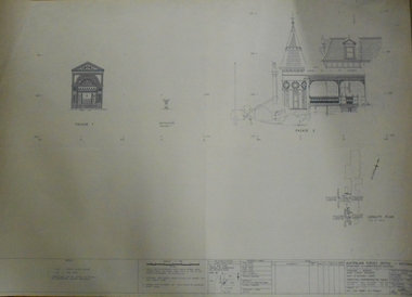
Plan - FORTUNA COLLECTION: FORTUNA VILLA
Originally built by Christopher Ballestedt (1796-1869) and his son Theodore. The Ballestedt's pioneered open cut and quartz mining on the Bendigo gold field. They were very successful. After Christopher's death, Theodore continued until 1871 when he sold Fortuna, their mines and equipment to George Lansell for 30,000 pounds.Four large plans of Fortuna villa. Scale 1:50 Australian survey office - Victoria Department of Administrative services. Fortuna Bendigo - Army Survey Regiment. Dept. of Defence - Army. Terrestrial Photogrammetric Survey. Project number: 8001/2. Reg. File: 64/531. Survey File:631. Draftsman: M.A. Osciak. Surveyed by G. Tucker. Date of Survey: 14/05/79. There are 4 large such plans in a plastic bag the measurement of the plans is approx. 115cm X 80 cm.plan, bendigo, fortuna villa -
 Bendigo Historical Society Inc.
Document - BENDIGO AND VICTORIA HILL REPORT ON GEOLOGY
Report, 8 pages, on the geology of Bendigo district and Victoria Hill, produced by the Geological Survey Dept., Victorian Government. G.J. Medwell, Geologist. 19.10.1967. On front 'Geological Survey of Victoria. Mines Department Victoria. Report on Geology of Bendigo and of Victoria Hill Area' Letter attached inside front cover to J.C.Balfour, Minister of Mines to G.A. Lambert, Liberal Party, Sunshine, Victoria, sent with book for his information. Report contains: Cobaw batholith and North Harcourt Bendigo goldfield generally Trought, reefs, saddles and spurs Victoria Hill mines; Victoria Consols, Great Central Victoria, Victoria Quartz, Lansells 180, North Old Chum. Maps attached show part of New Chum line of reef and a handdrawn map of Rae's Cutting.bendigo, mining, victoria hill, bendigo goldfield -
 Bendigo Historical Society Inc.
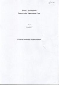
Document - HUSTLERS REEF RESERVE CONSERVATION MANAGEMENT PLAN
Conservation management plan (112 pages) prepared by Lee Andrews & Associates, Heritage Consultants, in 2011, for the Hustlers Reef Reserve. The reserve cover the site of the former Great Extended Hustlers Mine site. Leigh McKinnons amendments to the plan are included with the document. History of the site, a physical survey and analysis, comparative analysis, cultural significance and conservation policy are addressed in the document.bendigo, mining, great extended hustlers mine site -
 Bendigo Historical Society Inc.
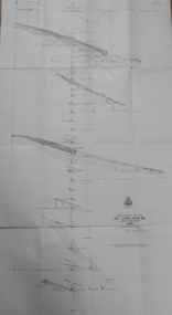
Map - GREAT EXTENDED HUSTLER'S MINE - LONGITUDINAL SECTION OF THE GREAT EXTENDED HUSTLER'S MINE
Longitudinal Section of the Great Extended Hustler's Mine on the Hustler's Line of Reefs. Bulletin No 33, Plate No XIII. Map shows the Hustler's Tribute, 2 Old Shafts, Great Extended Hustler's Shaft, Latham & Watson's Shaft and Ironbark Gully. Datum Line 750 feet above Sea Level. Poppet Legs on the surface and Sill of Shaft 788.99 feet above Sea Level. Levels and their depths are shown and some geographical features. Some amounts of gold mined mentioned. Geological Survey of Victoria emblem and signed by H A Whitelaw, Underground Survey Office Bendigo, September 1913. Note - Plates 4, 8, 13,20, 26 & 31 form a Longitudinal Section from Fortuna Hustlers to Hustler's Consols Mine. mining, parish map, great extended hustler's mine, geological survey of victoria, underground survey office bendigo, h a whitelaw, hustler's tribute, old shaft, great extended hustler's shaft, latham & watson's shaft, ironbark gully -
 Bendigo Historical Society Inc.
Map - GREAT EXTENDED HUSTLER'S MINE - TRANSVERSE SECTION OF THE GREAT EXTENDED HUSTLER'S MINE
Transverse Section of the Great Extended Hustler's Mine on the Hustler's Line of Reef. Bulletin No 33, Plate No XII. Shows Poppet legs at the surface and Sill of Shaft at 788.99 feet above Sea Level, Cross Cuts and their depths, stone and geographical features encountered and their references and a number of enlarged drawing of sections of the crosscuts, Geological Survey of Victoria emblem and signed by H A Whitelaw, Underground Survey Office Bendigo, September 1913. The depths of crosscuts to No 21 were taken from plans of surveys by Mr. Walker and Mr. Craven, noted under Reference. Another note: This Saddle Reef is sketched from Mr. Walker's plan. Dividends amounting to 360,000 pounds were obtained from it. mining, parish map, great extended hustler's mine, transverse section of the great extended hustler's mine, old shaft, mr walker, mr craven, geological survey of victoria, underground survey office bendigo, h a whitelaw -
 Bendigo Historical Society Inc.
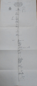
Map - GREAT EXTENDED HUSTLER'S MINE - PLAN OF THE GREAT EXTENDED HUSTLER'S MINE
Plan of the Great Extended Hustler's Mine on the Hustler's Line of Reefs, Bendigo. Bulletin No 33, Plate No X. Lease No 7382. Plan has map of streets. Mine was located in the block bounded by Langston and Anderson Streets and was between the Hustler's Anticline at Surface and the Lightning Hill Anticline at Surface. Latham & Watson's Shaft is also mentioned. Levels are numbered and a table shows the Levels and their Depths. Geological Survey of Victoria. Signed by H A Whitelaw, Underground Survey Office, Bendigo, September 1913. This item has not been scanned or photographed.mining, parish map, great extended hustler's mine, hustler's line of reefs, mining lease no 7382, geological survey of victoria, underground survey office bendigo, h a whitelaw, latham & watson's shaft -
 Bendigo Historical Society Inc.
Map - GREAT EXTENDED HUSTLER'S MINE - PLAN OF THE GREAT EXTENDED HUSTLER'S MINE
Plan of the Great Extended Hustler's Mine. Bulletin No 33, Plate No XI. Shows No 2 Shaft, Latham & Watson's Shaft, levels and their depths and some geographical features. Geographical Survey of Victoria emblem and signed by H A Whitelaw, Underground Survey Office, Bendigo, September 1913. Has reference to photos.mining, parish map, great extended hustler's mine, no 2 shaft, latham & watson's shaft, geological survey of victoria, underground survey office bendigo, h a whitelaw -
 Bendigo Historical Society Inc.
Map - FORTUNA HUSTLER'S MINE - TRANSVERSE SECTION OF THE FORTUNA HUSTLER'S MINE
Transverse Section of the Fortuna Hustler's Mine on the Hustler's Line of Reef, Bendigo. Bulletin No 33, Plate No III. Drawing shows poppet legs on the surface and Sill of Shaft 745.38 feet above Sea Level. Shows levels and their depths, geographical features and stone encountered. Reference table to stone and geographical features. Geographical Survey of Victoria emblem. Signed by H A Whitelaw, Underground Survey Office, Bendigo. mining, fortuna hustler's mine, hustler's line of reef, geological survey of victoria, underground survey office bendigo, h a whitelaw -
 Bendigo Historical Society Inc.
Map - FORTUNA HUSTLER'S MINE - LONGITUDINAL SECTION OF THE FORTUNA HUSTLER'S MINE
Longitudinal Section of the Fortuna Hustler's Mine on the Hustler's Line of Reef, Bendigo. Bulletin No 33, Plate No IV. Shows poppet legs at the surface level, Datum Line 750 feet above Sea Level, levels and their depths, the amount of gold per ton and some geographical features. Geological Survey of Victoria emblem and signed by H A Whitelaw, Underground Survey Office, Bendigo. Note - Plates 4, 8, 13, 20, 26 & 31 form a Longitudinal Section from Fortuna Hustler's to Hustler's Consols Mine. mining, parish map, fortuna hustler's mine, longitudinal section of the fortuna hustler's mine, geological survey of victoria, h a whitelaw, underground survey office bendigo, hustler's line of reef, hustler's consols mine -
 Bendigo Historical Society Inc.
Map - FORTUNA HUSTLER'S MINE - PLAN OF THE FORTUNA HUSTLER'S MINE
Plan of the Fortuna Hustler's Mine, Bulletin No 33, Plate No II. Geological Survey of Victoria. Signed by H A Whitelaw, Underground Survey Office Bendigo, September 1913. Map shows levels and depths. There are smaller drawings of some sections of some levels. mining, parish map, fortuna hustler's mine, plan of the fortuna hustler's mine, geological survey of victoria, h a whitelaw, underground survey office bendigo -
 Bendigo Historical Society Inc.
Map - HUSTLER'S REEF MINE - EAST & WEST CROSS-CUTS, NORTH & SOUTH OF SHAFT
East & West Crosscuts, North & South of Shaft, Hustler's Reef Mine Bulletin No 33, Plate No XIX. Map shows main shaft and smaller drawing of section with different stone encountered. Also gives location in relation to the shaft, e. g. 225'E & 150'S of Shaft. Reference diagram to show the different stone and features encountered. Geological Survey of Victoria emblem. Signed by H A Whitelaw, Underground Survey Office Bendigo, September 1913. mining, parish map, hustler's reef mine, east & west cross-cuts north & south of shaft, geological survey of victoria, h a whitelaw, underground survey office bendigo -
 Bendigo Historical Society Inc.
Map - HUSTLER'S REEF MINE - TRANSVERSE SECTION OF THE HUSTLER'S REEF MINE
Transverse Section of the Hustler's Reef Mine on the Hustler's Line of Reefs. Bulletin No 33, Plate No XVIII. Shows cross-cuts and their depth, different types of stone and geological features encountered. Drawing of poppet legs at the surface and Sill of Shaft 756.39 ft above Sea Level. Reference Table shows key to the different stone and geographical features encountered. Geographical Survey of Victoria. Signed by H A Whitelaw, Underground Survey Office, Bendigo, September 1913. Thompson's Reef is also mentioned on the map. mining, hustler's reef mine, transverse section of the hustler's reef mine, geological survey of victoria, h a whitelaw, underground survey office bendigo, thompson's reef. -
 Bendigo Historical Society Inc.
Map - HUSTLER'S CONSOLS MINE - TRANSVERSE SECTION OF THE HUSTLER'S CONSOLS MINE
Transverse Section of the Hustler's Consols Mine Bulletin No 33, Plate No XXXIII. Map shows poppet legs at the surface and Sill of Shaft 779.42 feet above Sea Level. Shows the different levels and their depths and the different stone and geographical features encountered. Has larger drawing of Section A - B. Geographical Survey of Victoria. Signed by H A Whitelaw, Underground Survey Office Bendigo, September 1913. mining, parish map, hustler's consols mine, transverse section of the hustler's consols mine, geological survey of victoria, underground survey office bendigo, h a whitelaw -
 Bendigo Historical Society Inc.
Document - VICTORIA HILL - QUESTION 5 ON VICTORIA HILL
Handwritten notes and carbon copy titled Question 5. Notes refer to Victoria Hill being opened up by Theodore Ballerstedt and his son early in 1854. Theodore Ballerstedt left for Germany having sold his home, crushing battery and mine to Mr. Geo Lansell. He called the mine the '180'. Next mine north to the '180' was the Victoria Quartz. Also contains notes on machinery, geological formations and earning from the mines.document, gold, victoria hill, victoria hill, question 5 on victoria hill, theodore ballerstedt, mr geo lansell, fortuna villa, commonwealth survey regiment, the 180, ballerstedt's original open cut, bendigo south rotary club, john wybrandt, north old chum coy, victoria quartz, victoria reef quartz company, mr william rae, a roberts & sons united ironworks, australian mining standard special edition 1899, bendigo advertiser 10/2/1897, a harkness & coy, bendigo advertiser 30/6/1910 page 5, rae's open cut, e j dunn, bendigo saddle reefs, wittscheibe's 'jeweller's shop', roberts & frost, ashley noy & coy, grant & co, woodward & son, couth allen and co, taylor gould and co, crawshaw & co, roberts & co -
 Bendigo Historical Society Inc.
Document - Geological Survey of Victoria, Hustlers Line of Reef, Bendigo, April, 2014
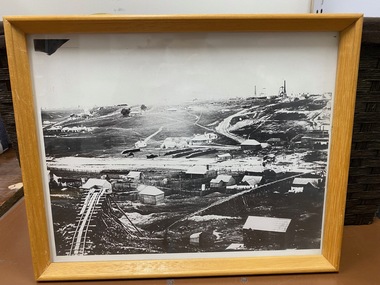
Seven men were killed at the Great Extended Hustler's mine disaster on 2nd May 1914 by an explosion of dynamite occurring as the men were waiting at the plat to ascend the mine at the end of their shift. No blame was attached to anyone in the findings of the inquisition. It was unknown what caused the dynamite to explode. This document formed part of the research done at the time by Bendigo Historical Society, of the 100 years commemoration of the mine disaster, held at Hustler's Hill in 2014. Seven page photocopy of Department of Mines, Bulletin, Geological Survey of Victoria, Hustlers Line of Reef, Bendigo, No. 33 by H.S. Whitelaw. Includes plan of Hustlers Royal Reserve No. 2, (main shaft) showing location on Pall Mall, and location of Post Office and Law Courts; plan of location of Hustlers Royal Reserve No. 2 (Park Shaft) showing Jail (sic), Camp Hill State School, two 'lagoons' in between tennis court, croquet court and bowling green; a plan of the Great Extended Hustler's Shaft and two copied images of Hustler's Hill showing mining buildings, poppet heads and chimneys. Comet, K.K., Hustler's No. 1, Old Comet and United Hustler's and Redan Mines are shown in the images. great extended hustlers, goldmining, accident, quartz, mining, k.k. mine, comet mine, hustler's line of reef, old comet, united hustler's, redan -
 Clunes Museum
Photograph, ca1861
When Richard Daintree rejoined the Victorian Geological Survey as a field surveyor in January 1859, he pioneered the use of photography in field-work. The glass plates attributed to him by the State Library of Victoria show four images of the mines in Clunes, Victoria, Australia in the 1860'sBlack and white reproduction of Port Phillip Colonial & Gold Mining Co., Clunes, Victoria, Australia in a light wood timber frameOn Reverse: Handwritten in pencil Port Phillip Co. 1860's Nettleton Photography glass plate Latrobe Libraryport phillip and colonial gold mining co., richard daintree -
 Bendigo Historical Society Inc.
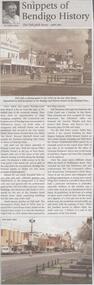
Newspaper - JENNY FOLEY COLLECTION: SNIPPETS OF BENDIGO
BHS CollectionBendigo Weekly - Snippets of Bendigo History, The Pall Mall story, part one - By Edith Lunn. Pall Mall was the vision of Richard Larritt who, from the Survey Office (Dudley House) at the top of View Street created order out of the chaos of the early alluvial mining activities along the Bendigo creek. Much history attaches to Pall Mall. The Freemasons' hotel, built in 1858, later renamed the Court house hotel, stands on the Mundy Street corner. In 1902 Sidney Myer opened his first shop close by. Bill Hampton had a grocery business and Colin Creek was a butcher in this block. On the Bull Street corner, Taylor Bros erected a two storied building for their drapery business. Crossing over Bull Street the former Commercial hotel stood on the corner from 1868. Many different shops filled the block to Williamson Street, they included Mr and Mrs Pedersen's café, the Gas Company's office, Fontawayne's frock shop, Hume and Iser, Doug Pain jeweller. The clip is in a folder.newspaper, bendigo, bendigo weekly -
 Bendigo Historical Society Inc.
Document - VICTORIA HILL - VICTORIA HILL AND NEW CHUM HILL
Typed notes on Victoria Hill and New Chum Hill. Notes give location, value of gold and plans for a mining museum.document, gold, victoria hill, victoria hill and new chum hill, john neil macartney, the age, the australasian, bendigo goldfields registry 1871, victoria reef quartz mine, north old chum, victoria consols, new chum and victoria, pioneer, lansell 222 mine, lazarus, barnet lazarus, mt. alvernia hospital, fortuna villa, george lansell, a. h. q. survey regiment, central red white and blue, hudsons, burrowes & sterry, b c v channel 8, bendigo and district tourist association, section 14 of the lands act 1958, mr a r richardson, cr t r flood, tourist association -
 The Beechworth Burke Museum
Geological specimen - Garnet crystals in galena, Unknown
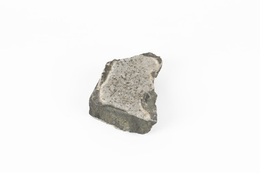
Majority of Galena in Australia is found in hydrothermal deposits emplaced around 1680 million years ago which have been heavily metamorphosed. Galena is the natural mineral form of lead sulfaide. It occurs generally as fine to large crystals due to syntectonic remobilization at low temperatures and moves to a suitable location. The colour is a shining lead and silvery gray with high specific gravity between 7.2 and 7.6 gms/cm3 and contains 86.6 lead sulfaide in its purest form. Its cyrstal system is cubic with perfect cleavages, and contract penetration and lamellar twinning. This particular specimen is from the Broken Hill mine, it is one of the largest lead mines located in Western New South Wales and still has ore reserves amounting to 20.9 million tonnes of ore grading of 7.4% lead, 9.4% zinc, and 61.5 million oz of Silver. Throughout its history, it has produced over 200 million tonnes of ore throughout its 127 years of mining history dating back to 1885. Galena mineral ore found in Australia is considered rare, as it is only currently found in the Broken Hill Mine of Western New South Wales. It represents heritage value through the systematic collecting of the geological surveyers in Victoria and Australia during the early to late 19th Century. The fact that it is only found in one mining area of Australia, shows that this specimen is rare for examples of Australian Galena. This mineral specimen is one part to a larger collection, aquistion, and distribution of Garnet in Galena around Australia and parts of the world and donated to the Burke Museum between 1860-1880. While this specimen was not found by the Victorian Geological Survey, it shows the historical need for mapping geological areas around the Gold Rush region to further identify areas of precious metal and gem aquisition. Additionally, collecting these specimens was an important part of mapping the scientific make up of the earth's surface. Many were sent to institutions for further contribution to research and scientific knowledge of the specimens. A solid coin-sized lead and zinc sulphaide and zinc silicate ore mineral in shades of black and red with shiny black points. GARNET CRYSTALS in / GALENA (lead sulphide), / SPALERITE (zinc sulphide), / WILLEMITE (zinc silicate) ore. / Locality: Broken Hill, NSWburke museum, #beechworth, indigo shire, beechworth museum, geological, geological specimen, mineral, galena, galena quartz, broken hill mine, broken hill, nsw -
 The Beechworth Burke Museum
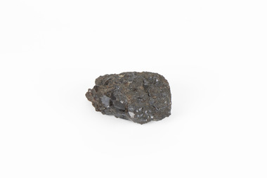
Geological specimen - Pyrite crystals in black slate, Unknown
Pyrite also known as iron Pyrite or fools gold is an iron sulfide with a chemical formula of FeS2 and is the most abundant sulfide mineral. Its metallic luster and pale brass-yellow hue give it a superficial resemblance to gold for which its nickname of Fools Gold comes from. There are a number of iron pyrite mines in Victoria and many would have been mined during Victoria's Gold Rush revolution in the 19th century. As it's lustrius yellow metallic look closely resembles gold, it is likely that it was often mistaken for gold as real gold was also often found in similar metamorphic and sedimentary rock. This specimen is part of a larger collection of geological and mineral specimens collected from around Australia (and some parts of the world) and donated to the Burke Museum between 1868-1880. A large percentage of these collections were collected in Victoria as part of the Geological Survey of Victoria that begun in 1852 (in response to the Gold Rush). Collecting these specimens was an important part of Australia's early Geoplogical scientific discovery for mapping the earth's surface. It is unknown where in Victoria this specimen was mined from however; it shows strong provenance connections to Victoria's gold mining history and represents through larger economic and cultural structures the impact the Gold Rush had on Victoria during the 19th century. A solid coin-sized Pyrite crystal in black slate in shades of beige with tiny crystal structures. Pyrite / crystals / BB / in black slate / probably / victoria / (nice specimen)geology, geological specimen