Showing 1524 items
matching no. 1 creek
-
 Greensborough Historical Society
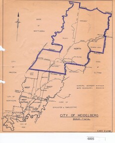
Map, City of Heidelberg, City of Heidelberg, 1962, 02/02/1962
Map of City of Heidelberg showing boundaries of its six wards; North Ward is highlighted, covering Watsonia, Greensborough, part Bundoora, St Helena, Plenty, Yarrambat and Diamond Creek.Blue print mapCity of Heidelberg Scale: 1" to 1 ml. G.M.H. 2.2.62city of heidelberg, heidelberg - maps -
 Greensborough Historical Society
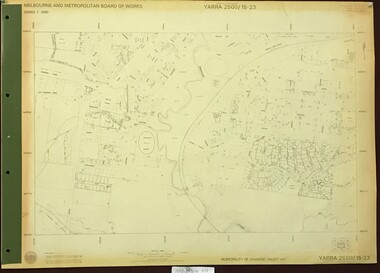
Map, Melbourne and Metropolitan Board of Works. Survey Division, MMBW, Yarra 2500 / 13.21. Central Greensborough, 1979_05
Melbourne and Metropolitan Board of Works. Yarra 2500 [base map]. 13-21, Parishes of Keelbundora 2856 and Nillumbik 3310, Municipality of Diamond Valley 257. Shows street names, easement sizes, lot numbers, lodged plan numbers, names of prominent features, contour values, creek or river names. Central Greensborough. Prominent streets: Main Street, Para Road, St Helena Road and Diamond Creek Road.MMBW Map in 1:2500 [scale] series. Cream parchment with green tape reinforcing on edges and punched holes on left edge.mmbw, melbourne and metropolitan board of works, shire of diamond valley, greensborough - maps -
 Greensborough Historical Society
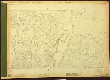
Map, Melbourne and Metropolitan Board of Works. Survey Division, MMBW, Yarra 2500 / 12.20. Watsonia Railway Station and environs, 1983_03
Melbourne and Metropolitan Board of Works. Yarra 2500 [base map]. 12-20, Parishes of Keelbundora 2856, Municipalities of Diamond Valley 257 and 228. Shows street names, easement sizes, lot numbers, lodged plan numbers, names of prominent features, contour values, creek or river names. Watsonia Railway Station and environs. Prominent streets: Watsonia Road, Elder Street, Morwell Avenue and Nepean Street. Includes former Watsonia Technical School and Gresswell Rehabilitation Centre sites.MMBW Map in 1:2500 [scale] series. Cream parchment with green tape reinforcing on edges and punched holes on left edge.mmbw, melbourne and metropolitan board of works, shire of diamond valley, watsonia - maps -
 Greensborough Historical Society
Map, Melbourne and Metropolitan Board of Works. Survey Division, MMBW, Yarra 2500 / 12.19. Watsonia, Simpson Army Barracks, 1983_03
Melbourne and Metropolitan Board of Works. Yarra 2500 [base map]. 12-19, Parish of Keelbundora 2856, Municipalities of Diamond Valley 257 and 228. Shows street names, easement sizes, lot numbers, lodged plan numbers, names of prominent features, contour values, creek or river names. Watsonia Barracks (Simpson Army Barracks) and environs. Prominent streets: Yallambie Road, Greensborough Road, and Strathallan Road. MMBW Map in 1:2500 [scale] series. Cream parchment with green tape reinforcing on edges and punched holes on left edge.mmbw, melbourne and metropolitan board of works, shire of diamond valley, watsonia - maps -
 Greensborough Historical Society
Map, Melbourne and Metropolitan Board of Works. Survey Division, MMBW, Yarra 2500 / 12.22. Watsonia North, 1978_03
Melbourne and Metropolitan Board of Works. Yarra 2500 [base map]. 12-22, Parishes of Keelbundora 2856, Municipalities of Whittlesea 239 and Diamond Valley 257. Shows street names, easement sizes, lot numbers, lodged plan numbers, names of prominent features, contour values, creek or river names. Watsonia Railway Station and environs. Prominent streets: Edmund Rice Parade and Macorna Street. Includes Christian Brothers Edmund Rice College and Janefield Special School sites and "proposed future freeway" (now Metropolitan Ring Road).MMBW Map in 1:2500 [scale] series. Cream parchment with green tape reinforcing on edges and punched holes on left edge.mmbw, melbourne and metropolitan board of works, shire of diamond valley, watsonia - maps, bundoora - maps -
 Greensborough Historical Society
Map, Melbourne and Metropolitan Board of Works. Survey Division, MMBW, Yarra 2500 / 12.21. Watsonia North, 1979_02
Melbourne and Metropolitan Board of Works. Yarra 2500 [base map]. 12-22, Parish of Keelbundora 2856, Municipality of Diamond Valley 257. Shows street names, easement sizes, lot numbers, lodged plan numbers, names of prominent features, contour values, creek or river names. Watsonia Railway Station and environs. Prominent streets: Grimshaw Street, William Street and Macorna Street. Includes former Institute of Social Welfare (now Loyola College) Lines Reserve and Binnak Park.MMBW Map in 1:2500 [scale] series. Cream parchment with green tape reinforcing on edges and punched holes on left edge.mmbw, melbourne and metropolitan board of works, shire of diamond valley, watsonia - maps, bundoora - maps -
 Greensborough Historical Society
Map, Melbourne and Metropolitan Board of Works. Survey Division, MMBW, Yarra 2500 / 12.24. Plenty and Blue Lake, 1977_10
Melbourne and Metropolitan Board of Works. Yarra 2500 [base map]. 12-24, Municipalities of Whittlesea 239 and Diamond Valley 257. Shows street names, easement sizes, lot numbers, lodged plan numbers, names of prominent features, contour values, creek or river names. Watsonia Railway Station and environs. Prominent streets: Memorial Drive. Includes Plenty River and Blue Lake in the Plenty Gorge.MMBW Map in 1:2500 [scale] series. Cream parchment with green tape reinforcing on edges and punched holes on left edge.mmbw, melbourne and metropolitan board of works, shire of diamond valley, plenty - maps, blue lake -
 Greensborough Historical Society
Map, Melbourne and Metropolitan Board of Works. Survey Division, MMBW, Yarra 2500 / 13.22. Greensborough, Apollo Parkways, 1979_06
Melbourne and Metropolitan Board of Works. Yarra 2500 [base map] 13-22. Greensborough, Apollo Parkways. Parishes of Nillumbik 3310 and Keelbundora 2856. Municipalities of Diamond Valley 257 and Whittlesea 239. Prominent streets include: Plenty River Drive, Diamond Creek Road and Civic Drive. Includes Diamond Valley Civi Centre, Churinga, Janefield Colony Reserve and "proposed freeway" now Greensborough Highway (Bypass)MMBW Map in 1:2500 [scale] series. Cream parchment with green tape reinforcing on edges and punched holes on left edge.mmbw, melbourne and metropolitan board of works, shire of diamond valley, greensborough - maps, apollo parkways - maps -
 Greensborough Historical Society
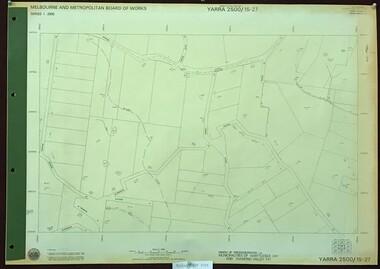
Map, Melbourne and Metropolitan Board of Works. Survey Division, MMBW, Yarra 2500 / 17.27. Central Hurstbridge, 1978_02
Melbourne and Metropolitan Board of Works. Yarra 2500 [base map] 17-27. Central Hurstbridge. Parish of Greensborough 2724, Municipalities of Diamond Valley 257, Eltham 238 and Whittlesea 239. Prominent streets include: Anzac Avenue and Hurstbridge-Arthurs Creek Road. MMBW Map in 1:2500 [scale] series. Cream parchment with green tape reinforcing on edges and punched holes on left edge.mmbw, melbourne and metropolitan board of works, shire of diamond valley, hurstbridge - maps -
 Greensborough Historical Society
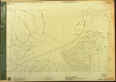
Map, Melbourne and Metropolitan Board of Works. Survey Division, MMBW, Yarra 2500 / 16.24. Northern Diamond Creek and Wattle Glen, 1978_02
Melbourne and Metropolitan Board of Works. Yarra 2500 [base map] 16-24. Northern Diamond Creek and Wattle Glen. Parishes of Nillumbik 3310 and Greensborough 2724. Municipalities of Diamond Valley 257 and Eltham 238. Prominent streets include: Hurstbridge Road, and Reynolds Road. Includes Wattle Glen Station.MMBW Map in 1:2500 [scale] series. Cream parchment with green tape reinforcing on edges and punched holes on left edge.mmbw, melbourne and metropolitan board of works, shire of diamond valley, wattle glen - maps, diamond creek - maps -
 Greensborough Historical Society
Map, Melbourne and Metropolitan Board of Works. Survey Division, MMBW, Yarra 2500 / 16.23. Diamond Creek, 1978_02
Melbourne and Metropolitan Board of Works. Yarra 2500 [base map] 16-23. Diamond Creek. Parish of Nillumbik 3310. Municipalities of Diamond Valley 257 and Eltham 238. Prominent streets include: Phipps Crescent, Bishop Avenue, and Reynolds Road. Includes the former Diamond Creek Technical School.MMBW Map in 1:2500 [scale] series. Cream parchment with green tape reinforcing on edges and punched holes on left edge.mmbw, melbourne and metropolitan board of works, shire of diamond valley, diamond creek - maps -
 Greensborough Historical Society
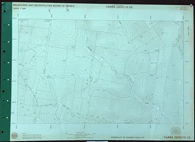
Map, Melbourne and Metropolitan Board of Works. Survey Division, MMBW, Yarra 2500 / 16.22. Research, 1979_05
Melbourne and Metropolitan Board of Works. Yarra 2500 [base map] 16-22. Research. Parish of Nillumbik 3310. Municipalities of Diamond Valley 257 and Eltham 238. Prominent streets include: Orme Road and Allendale Road. MMBW Map in 1:2500 [scale] series. Cream parchment with green tape reinforcing on edges and punched holes on left edge.mmbw, melbourne and metropolitan board of works, shire of diamond valley, diamond creek - maps -
 Greensborough Historical Society
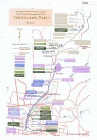
Maps, Yan Yean Water Supply System Conservation Management Plan: Construction dates Map 1, 2007_
Plan of Yan Yean Water Supply System, showing natural and constructed features from 1850s to 1930s from Silver Creek Weirs to Eastern Freeway.Printed in colour one side. 3 copieswater supply, yan yean reservoir, plenty river -
 Greensborough Historical Society
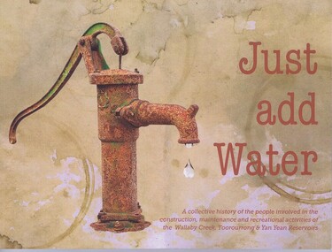
Book, Friends of Toorourrong Inc, Just add water, 2019_
History of the people and organisations associated with the Yan Yean and Toorourrong Reservoirs, and with Wallaby Creek compound. Book launch report by Anne Paul.Paperback book, 109 p., colour and black and white photographs. And a 1 page typed report on the book launch.yan yean reservoir, water supply, toorourrong reservoir -
 Greensborough Historical Society
Article, John Daniels: following the footsteps of Batman, by Jan Hanslow, 11/07/2014
... . batmans treaty john daniels john batman merri creek 1 p. reprint ...Discussion of John Daniels' theory that "Batman's Treaty" was signed on the southern bank of the Merri Creek in Reservoir. It follows Batman up the Maribyrnong River and his meeting with 'a native family' who took him to the Merri Creek.1 p. reprint of address at general Meeting [of Port Phillip Pioneers Group?] 11 July 2014, by Jan Hanslowbatmans treaty, john daniels, john batman, merri creek -
 Greensborough Historical Society
Map, Melbourne and Metropolitan Board of Works. Survey Division, MMBW, Yarra 2500 / 15.23. Diamond Creek Reserve, 1978_02
Melbourne and Metropolitan Board of Works. Yarra 2500 [base map] 15.23. Hurstbridge. Municipality of Diamond Valley 257. Prominent streets include: Challenger Street, James Cook Drive and Ryans Road / Main Street. Features include the Diamond Creek and Diamond Creek Reserve.MMBW Map in 1:2500 [scale] series. Cream parchment with green tape reinforcing on edges and punched holes on left edge.mmbw, melbourne and metropolitan board of works, shire of diamond valley, diamond creek - maps -
 Greensborough Historical Society
Map, Melbourne and Metropolitan Board of Works. Survey Division, MMBW, Yarra 2500 / 15.22. Eltham North. Allendale Road, 1979_08
Melbourne and Metropolitan Board of Works. Yarra 2500 [base map] 15.22. Eltham North, Allendale Road. Parish of Nillumbik. Municipalities of Eltham 238 and Diamond Valley 257. Prominent streets include: Allendale Road, Godber Road and Ryans Road. Features include the Diamond Creek.MMBW Map in 1:2500 [scale] series. Cream parchment with green tape reinforcing on edges and punched holes on left edge.mmbw, melbourne and metropolitan board of works, shire of diamond valley, nillumbik, eltham - maps -
 Greensborough Historical Society
Map, Melbourne and Metropolitan Board of Works. Survey Division, MMBW, Yarra 2500 / 15.21. Eltham North, 1979_08
Melbourne and Metropolitan Board of Works. Yarra 2500 [base map] 15.21. Eltham North. Parish of Nillumbik 3310. Municipalities of Diamond Valley 257 and Eltham 238. Prominent streets include: Progress Road, Glen Park Road and Zig Zag Road. Features include the Diamond Creek, Eltham Council Pound and Eltham North Reserve.MMBW Map in 1:2500 [scale] series. Cream parchment with green tape reinforcing on edges and punched holes on left edge.mmbw, melbourne and metropolitan board of works, shire of diamond valley, nillumbik, eltham - maps -
 Greensborough Historical Society
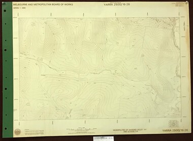
Map, Melbourne and Metropolitan Board of Works. Survey Division, MMBW, Yarra 2500 / 16.26. Diamond Creek, Broadgully Road, 1978_07
Melbourne and Metropolitan Board of Works. Yarra 2500 [base map] 16.26. Diamond Creek, Broad Gully Road. Municipalities of Diamond Valley 257 and Eltham 238. Prominent streets include: Wadeson Road, Broad Gully Road and Glenhaven Road. Features include the Diamond Creek.MMBW Map in 1:2500 [scale] series. Cream parchment with green tape reinforcing on edges and punched holes on left edge.mmbw, melbourne and metropolitan board of works, shire of diamond valley, diamond creek - maps -
 Greensborough Historical Society
Map, Melbourne and Metropolitan Board of Works. Survey Division, MMBW, Yarra 2500 / 14.23. Diamond Creek, Sutherland Homes, 1979_05
Melbourne and Metropolitan Board of Works. Yarra 2500 [base map] 14.23. Diamond Creek, Sutherland Homes. Parish of Morang 3183 and Nillumbik 3310. Municipality of Diamond Valley 257. Prominent streets Aqueduct Road, Diamond Creek Road, Yan Yean Road and McLaughlans Lane. Features include the abandoned Maroondah aqueduct and Sutherland Cottages.MMBW Map in 1:2500 [scale] series. Cream parchment with green tape reinforcing on edges and punched holes on left edge.mmbw, melbourne and metropolitan board of works, shire of diamond valley, plenty - maps, sutherland homes, maroondah aqueduct -
 Greensborough Historical Society
Map, Melbourne and Metropolitan Board of Works. Survey Division, MMBW, Yarra 2500 / 15.27. Yarrambat, De Fredricks Lane, 1977_10
Melbourne and Metropolitan Board of Works. Yarra 2500 [base map] 15.27. Yarrambat, De Fredricks Lane. Parish of Greensborough 2724. Municipality of Diamond Valley 257 and Whittlesea 239. Prominent streets include: De Fredricks Lane, Astons Road and Bannons Lane. Features include Scrubby Creek.MMBW Map in 1:2500 [scale] series. Cream parchment with green tape reinforcing on edges and punched holes on left edge.mmbw, melbourne and metropolitan board of works, shire of diamond valley, yarrambat - maps -
 Greensborough Historical Society
Map, Melbourne and Metropolitan Board of Works. Survey Division, MMBW, Yarra 2500 / 15.26. Yarrambat, Hacketts Road, 1978_07
Melbourne and Metropolitan Board of Works. Yarra 2500 [base map] 15.26. Yarrambat, Hacketts Road. Municipality of Diamond Valley 257. Prominent streets include: Black Gully Road, Hacketts Road and Collins Lane. Features include Scrubby Creek.MMBW Map in 1:2500 [scale] series. Cream parchment with green tape reinforcing on edges and punched holes on left edge.mmbw, melbourne and metropolitan board of works, shire of diamond valley, yarrambat - maps -
 Greensborough Historical Society
Map, Melbourne and Metropolitan Board of Works. Survey Division, MMBW, Yarra 2500 / 15.24. Diamond Creek, Grassy Flat Road, 1978_02
Melbourne and Metropolitan Board of Works. Yarra 2500 [base map] 15.24. Diamond Creek, Grassy Flat Road. Parish of Nillumbik 3310. Municipality of Diamond Valley 257. Prominent streets include: Everleigh Drive, Broad Gully Road and Clyde Street. Features include the Diamond Creek, Nillumbik Park and Diamond Creek Reservoir.MMBW Map in 1:2500 [scale] series. Cream parchment with green tape reinforcing on edges and punched holes on left edge.mmbw, melbourne and metropolitan board of works, diamond creek - maps, shire of diamond valley -
 Greensborough Historical Society
Newspaper Clipping, Diamond Valley Leader, Hell On Wheels: Cyclists safety concerns, 06/03/2019
Diamond Valley cyclists are calling for better safety as they negotiate one of the area's busiest roads. A bike lane needs to be continuous along Main Road Eltham. News article 1 page, black text.eltham, diamond creek, greensborough, cyclists, bike lanes -
 Greensborough Historical Society
Newspaper Clipping, Diamond Valley Leader, Last drinks for Pat's pub, 13/03/2019
The Windy Mile pub in Diamond Creek has 'never been the same" since teenager Patrick Cronin died from a senseless coward punch at the bar almost three years ago.The Windy Mile will serve its last drink on Sunday, March 31 2019.News article 1 page, black text.windy mile, diamond creek, patrick cronin, cronin family -
 Greensborough Historical Society
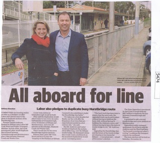
Newspaper Clipping, Diamond Valley Leader, All aboard for line, 08/08/2018
Premier Daniel Andrews flanked by Eltham state Labor MP Vicki Ward and Public Transport Minister Jacinta Allan, last week announced Labor would duplicate 3km of track between Greensborough and Montmorency plus 1.5km between Diamond Creek and Wattle Glen. In this article local MPs Colin Brooks and Vicki Ward are shown standing on Greensborough Station.News article 1 page, black text and colour image .hurstbridge rail line, greensborough, montmorency, daniel andrews, vicki ward, colin brooks -
 Greensborough Historical Society
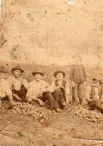
Photograph - Digital image, Onion Farm Greensborough, 1920c
... Two photographs of the Onion Farm, Diamond Creek Road..., Diamond Creek Road Greensborough. Photo 1 is not captioned; photo ...Two photographs of the Onion Farm, Diamond Creek Road Greensborough. Photo 1 is not captioned; photo 2 (left to right) Harris the owner, unknown male, William Thomas Finn. Photographs from the collection of Peter Blackbourn, a descendant of the Chapman Stock family. Annotations to photos by Peter Blackbourn.Digital copy of two black and white photographs.peter blackbourn, william thomas finn, harris, onion farm greensborough -
 Greensborough Historical Society
Photograph - Digital Image, Pioneer Reserve 2014 -1, 21/05/2014
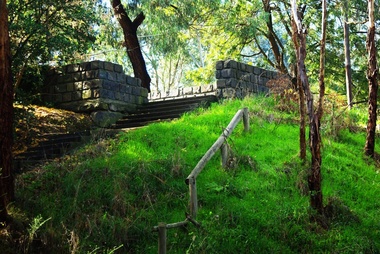
Pioneer Reserve, Greensborough is a small park on the corner of St Helena and Diamond Creek Roads. It is adjacent to the site of Greensborough's first bridge across the Plenty River, c. 1864 - 1960s. The shelter, viewing platform, retaining wall and entrance are built from the bridge's massive bluestone arched abutments dismantled between 1974 and 1983. Pioneer Reserve is historically significant for its formative association with noted local landscape designer Gordon Ford in 1968, and it is likely that remnant large field stones at the entrance drive to the Reserve remain from his design. Photograph by Marilyn Smith 2014.Digital copy of colour photograph. -
 Greensborough Historical Society
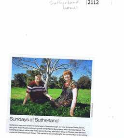
Newspaper clipping, Diamond Valley Leader, Sundays at Sutherland, 2013_
Desley Elkhom and Ralph Rudd, the owners of Sutherland (once an orphanage) run a Sunday market to raise money for Rotary. Neisha Forbes email 1/4/2017: "In this photograph is of my brother, Ralph Rudd and his partner Desley Elkhom, they were setting up a market at Sutherland Homes site – a community market trying to bring on local produce, and involve the Plenty CFA to raise money for equipment. It ran for about 2 years, but sadly as they did not have indoor cover, it either rained on the Sunday, they had the stalls, but did not get the people, or had the people and no stalls. It stopped about a 18 months ago. It was at 14 Yan Yean Road, Diamond Creek. At the intersection of Yan Yean Road and Diamond Creek Road, the old Sutherland Homes property."News clipping, black text, colour image. Text incomplete. -
 Greensborough Historical Society
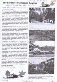
Article, Keith Patterson et al, The Eltham/Hurstbridge Railway, 1912-2012
Account of the extension and electrification of the Eltham to Hurstbridge railway line. Article is in two parts: Part 1: Steam days 1912-1925, published in Diamond Creek News, Autumn 2012; Part 2: Electrification 1926-2012, published in Nillumbik Custodian, v. 8, Issue 2, June 20123 pages, printed both sides. Text and illus. (some col.).eltham, hurstbridge, railways, hurstbridge rail line