Showing 2735 items
matching otway-reef
-
 Winchelsea and District Historical Society
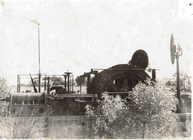
Collection photos, J W (Jack) McClelland, Circ.1915
A series of photos taken in the Otways circ. 1915 showing aspects of the logging operations The actual logging operations are show including logging , transport and mill operations. Also shown are views of the forest at that time including scenic attractions. The life style of the workers is covered showing both the working and living environments. The photos were taken by J W (Jack) McCleland on glass and copies were made available to the Winchelsea Historical Society by a descendant. The collection shows the working and living environment of workers in the timber industry in the early 1900'sSeries of 70 photos from glass plates showing logging by Hendy & Sons near Mt Sabine and views of the Otways. Taken around 1915Nilotways, timber, henry, sabine mcclelland, rail, photo, -
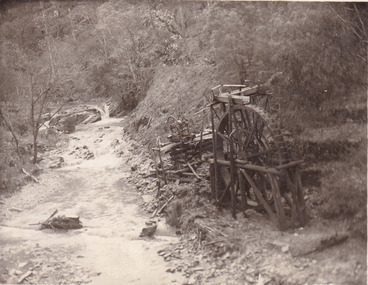 The Beechworth Burke Museum
Postcard, 1920
This postcard depicts the set-up of an abandoned gold mine. This includes a water wheel and other mining implements next to a creek. The postcard inscription indicates that this image is of the remains of the Wallaby Reef battery and water wheel. Wallaby Reef was discovered in 1864, and a prospecting claim established a four head battery and water wheel. Quartz was mined there, with gold also discovered at this location at a later date. By 1878 the mine was no longer resulting in rich deposits, this resulted in the miners moving their search for gold closer to the river where they were able to access more gold. This was in approximately 1879. In 1882 a rich deposit was found. In 1908 the battery was closed, and the mine finished. This photo was taken in 1920 and shows the deterioration of the site since its closure. Gold mining was crucial to the development of the Beechworth area. It has strong research and historical value because the clarity of the photo shows all the minute details of the mining equipment. The text on the back also indicates the mine is the Wallaby Mine, which was used for 45 years to find gold and quartz. Therefore, due to the location being quickly abandoned, this site is a rich location for historical study on gold mining during the 1900s. It can provide important information on the types of tools utilised and the impact of the mining on the environment.Black and white postcard photograph on card.8169 Be / Also near Wallaby Reef Workings / Relics of Rechabite Reef (locality) workings. / Shaft in bed of creek. Wheel used to drive sheadd (?) / stamp battery too I believe near B'worth 1920?beechworth, mining, gold mining, quartz mining, wallaby reef mine, mine battery head -
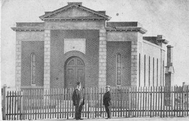 Stawell Historical Society Inc
Photograph, Baptist Church 1870
Two identical photos of Stawell Baptist Church 1870. Examples of Baume's Photographic work. One photo is more faded and has names Davies and Wm Anthony on the back. One of the two people standing outside the picket fence in front of the Church has a top hat on. Two identical photos of the front view of Baptist Church. There is a tall picket fence in front of the church with two men standing beside the fence. Photo taken by J Baume Portrait Rooms, Reefs Pleasant Creek c. 1871J. BAUME, Portrait Rooms, Reefs Pleasant Creek. No... Copies can be had by sending Names and Numbers. Davies & Wm Anthonystawell -
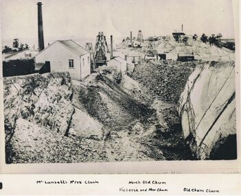 Bendigo Historical Society Inc.
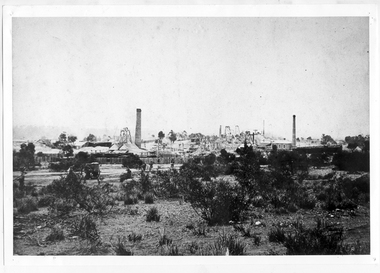
Photograph - LANSELL'S 180 CLAIM, approx. 1875
Black and white photograph of original. Large excavation in foreground. Weatherboard building at left with wood pile and brick chimney. 3 poppet heads in middle distance. 1 poppet head on horizon. Total of 4 chimneys visible. Im inage on original photo ' …. Reef near Ironbark Hill' In margin at bottom ' Mr. Lansell's No. 180 claim/North Old Chum/Victoria and New Chum/Old Chum Claim'Original photo by N.J. Caire, 1875, looking south New Chum or Victoria Reef'organization, business, lansell's 180 claim -
Unions Ballarat
The Great Barrier Reef (Don Woodward Collection), Embury, EM, 1933
From a series of Australian nature books. Brief information about life forms that inhabit the Great Barrier Reef.Australian life forms and the Great Barrier Reef.Book; 95 pages. Cover: red background; black illustration of Great Barrier Reef; black lettering; author's name and title.btlc, ballarat trades hall, ballarat trades and labour council, great barrier reef, oceanography, marine animals, corals - great barrier reef -
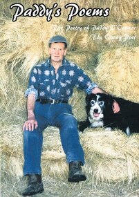 Otway Districts Historical Society
Book, Colac Herald Press, Paddy's Poems, 2004
Born in the Otways at Tanybryn in 1929 where he spent the bulk of his life he started writing poems in 1999 and since then has had over 100 poems listed. While many poems are memories of what has gone in Paddy's past he also pens about current day events, such as "Bob and Betty", or just about life as he sees it, such as "Diamonds in the Sky".Paddy's poems. The poetry of Paddy O'Connor, the Otway poet. P.J. O'Connor; Apollo Bay (Vic); 2004. vii, 121 p.; illus. Soft cover. ISBN 0 646 44331 3Paddy & Betty O'Connor 61 Wallace Street Colac VIC 3250paddy o'connor; poems; otways; -
 Otway Districts Historical Society
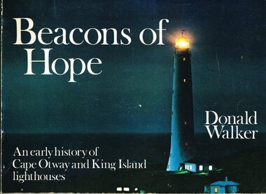
Book, Neptune Press Pty Ltd, Beacons of Hope, 1981
George Bass and Matthew Flinders made a voyage along the northern coast of Van Diemen's Land in 1798 to prove the existence of Bass Strait. The first vessel to attempt such a passage was the "Lady Nelson" under Lieutenant James Grant. Men sought out Bass Strait without the benefit of a lighthouse for the first half of the 19th Century after which, after several maritime disasters, on 29 August 1848, Cape Otway lighthouse commenced operation. Cape Wickham lighthouse, on King Island, joined its companion at Cape Otway on 1 November 1861.Beacons of hope. An early history of Cape Otway and King Island lighthouses. Donald Walker. 1st ed. Neptune Press; Belmont (Vic); 1981. ii, 154 p.; illus., maps, index. Soft cover. ISBN 0 909131 67 8Signed by author: Donald Walker.cape otway; king island; cape wickham; lighthouse; -
 Stawell Historical Society Inc
Photograph, Stawell Times News, Grampians Store in Pomonal -- Coloured
Inside Pomonal General Store with Peter & Jenny Greenberger 29/9/1998Gold Reef Photos retail -
 Otway Districts Historical Society
Book, Train Hobby Publications, Victorian Railways Narrow Gauge, Part 2, March 1999
An historical series setting out Garratt engines and running stock running between Colac and Crowes (just past Lavers Hill), and then between Colac and Beech Forest in the Otways between 1958 and 1962 when the line closed.Victorian Railways Narrow Gauge "G" Class. "Garratts in the Otways" Part Two. A photographic profile - 1958-1962. Emile D. Badawy (ed.); John Sargent (ed.). 1999; Train Hobby Publications. ii, 56 p.; illus., map. Soft cover. colac; beech forest; crowes; garratt; victorian railways; narrow gauge; emile d. badawy; john sargent; -
 Otway Districts Historical Society
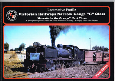
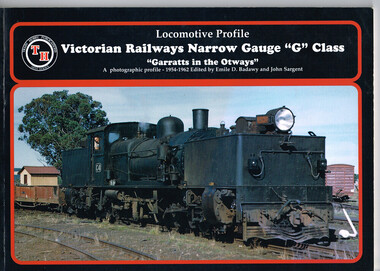
Book, Victorian Railways Narrow Gauge, Part Three, March 2001
The third in the historical series outlining the narrow gauge Victorian Railways line from Colac to Crowes, and then Colac to Beech Forest, in the Otways between 1954 and 1962 when the line closed. Victorian Railways Narrow Gauge "G" Class; "Garratts in the Otways" Part Three. A photographic profile - 1954-1968. Emile D. Badawy (ed.). 2001; Train Hobby Publications; Studfield (Vic). ii, 48 p.; illus. Soft cover. ISBN 1 876249 41 2colac; beech forest; crowes; victorian railways; narrow gauge; garratt; emile d. badawy; -
 Otway Districts Historical Society
Book, Train Hobby Publications, Victorian Railways Narrow Gauge, Part 1, March 1998
The first in an historical series showing the Victorian Railway narrow gauge line from Colac to Crowes, and then from Colac to Beech Forest, in the Otways from 1954 until 1962 when the line closed.Victorian Railways Narrow Gauge "G" Class. "Garratts in the Otways" Part One. A photographic profile - 1954-1962. Emile D. Badawy (ed.); John Sargent (ed.). 1998; Train Hobby Publications; Studfield (Vic). ii, 48 p.; illus., maps. Soft cover.colac; beech forest; crowes; victorian railways; garratt; narrow gauge; emile d. badawy; john sargent; -
Clunes Museum
Newspaper - NEWSPAPER CUTTING, ARGUS AGE, 1 CLUNES BIRTHDAY .2 FAMOUS MINING TOWNS, 4 - 7 - 1931 27 - 8 - 32
NEWSPAPER HEADLINES. CLUNES BIRTHDAY. FAMOUS MINING TOWNS .1. 80TH ANNIVERSARY JULY 4, 1931 .2. THE QUARTZ REEFS OF CLUNES. SOME INTERESTING DOCUMENTS..2 NEWSPAPER CUTTINGS. .1. CLUNES MINING 80TH ANNIVERSARY JULY 4, 1931 .2. THE QUARTZ REEFS OF CLUNES. SOME INTERESTING DOCUMENTS.local history, document, newspaper cutting, mining -
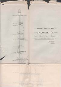 Bendigo Historical Society Inc.
Map - STRUGNELL COLLECTION: UNDERGROUND SURVEY OF MINES BENDIGO, 27-3-01
Map, Underground Survey of Mines, Shamrock Co., New Chum Line, Bendigo. Transverse Section, Garibaldi Reef, Young Chum Reef, Thorpe's Reef, Mundic Reef, Shenandoah Reef, New Chum Railway Reef, Surveyed under the Supervision of H.Herman.H.S.Whitelaw.map, bendigo, shamrock co. -
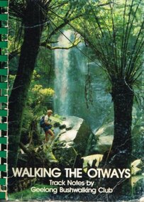 Otway Districts Historical Society
Book, Geelong Bushwalking Club Inc, Walking the Otways, November 1986
The Otways area of Victoria, at the time of writing, was an underused area for bushwalking. In the past, people have considered these ranges unsuited for walking because of the thick forest cover, cold and muddy conditions for much of the year, and the steep slopes. Some of the perceived difficulties are actually attractions and that it is possible to enjoy them with a forward planning and up-to-date information to guide the walker.The Geelong Bushwalking Club have included some useful but brief articles on basic aspects of bushwalking.Walking the Otways. Track notes compiled by the Geelong Bushwalking Club. Graeme Allen (ed.); John Van Gemert (maps, photographs). 1st ed. Geelong Bushwalking Club; Geelong (Vic); November 1986. 148 p.; illus, maps. Soft cover.otways; bushwalking; -
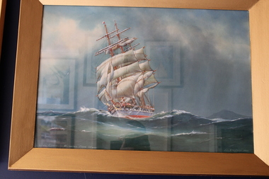
 Queenscliffe Maritime Museum
Painting - Water colour painting of the schooner Argosy Lemal, Argosy Lemal, c. 1930's
Arthur V Gregory b.1867, d.1957 worked from studio at 326 Albert Road South Melbourne established by his father G F Gregory in 1852. As Argosy Lemal the ship served as one of the early United States Army communications ships from 1942–1949.Water colour painting in painted gilt frameArgosy Lemal off Cape Otway A.V. Gregorya.v. gregory, water colour, argosy lemal -
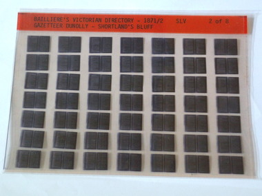 Rutherglen Historical Society
Microfiche, Bailliere's Victorian Directory 1871/2, 1871/72
A directory of all Towns in Victoria in 1886small sheet of film SLV Gazetteer Dunolly - ShortLand's Reeftown, names, victoria -
 Tarnagulla History Archive
Photograph: View of Poverty Mine, Tarnagulla, circa 1860s
Murray Comrie Collection. Monochrome photograph depicting view across Tarnagulla showing the Poverty Mine. Written on reverse: 'Poverty Reef Tarnagulla'.tarnagulla, views, poverty mine -
 Stawell Historical Society Inc
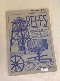
Magazine, Reefs Stawell Tech School, Reefs Magazine, of the Stawell Technical School 1956, 1956
School Magazine 1956Blue card Cover with blue drawing of poppet head and other mining equipment Reefs Magazine of the Stawell Technical Schoolstawell education -
 Stawell Historical Society Inc
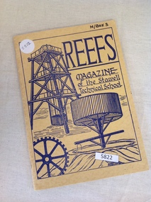
Magazine, Stawell Technical School, Reefs Magazine, of the Stawell Technical School 1960, 1960
Yearly magazine from the Stawell Technical School Yellow ccard cover with ink drawing of various mining structures.Reefs Magazine of the Stawell Technical Schoolstawell education -
Glenelg Shire Council Cultural Collection
Photograph - Photograph - Bridge Construction, 1957
Port of Portland Authority ArchivesBack: 'Bridgewater Rd 1957' - pencilport of portland archives, otway st bridge -
 Bendigo Historical Society Inc.
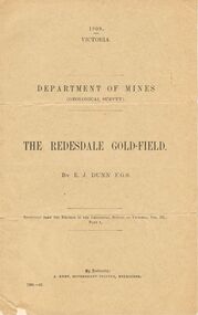
Document - MCCOLL, RANKIN AND STANISTREET COLLECTION: THE REDESDALE GOLDFIELD, 1909
1909 report from the Department of Mines Geological Survey on the Redesdale Goldfield by E. J. Dunn. F.G.S. Reefs mentioned are the Horseshoe Bend Reef, Linda Reef, Bill Smith's workings, the Ben Guy Reef and the Amelia ReefDepartment of Minesgold mining, miners' safety cage, redesdale goldfield, gold mining, redesdale. -
 Bendigo Historical Society Inc.
Photograph - NELL GWYNNE, MINING, c1900s early
Nell Gwynne Reefs winder, also card with 'Nell Gwynne Reefs' written on it. Inscriptions Nell Gwynne Reefs Winder.organization, business, nell gwynne reefs mine -
 Bendigo Historical Society Inc.
Document - GREAT EXTENDED HUSTLERS MINE - HUSTLERS LINE PECULIARITIES
Hand written notes on the peculiarities of the Hustlers Line of Reef. Notes on pitch of the reef and a peculiar type of false saddle reef.mine, gold, great extended hustlers., great extended hustlers mine, peculiarities of the reef, pitch of reef, false saddle reefs -
Glenelg Shire Council Cultural Collection
Photograph - Photograph - Bridge Construction, n.d
Port of Portland Authority Archivesport of portland archives, tidewater road, otway street bridge -
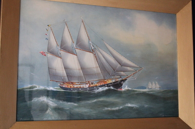
 Queenscliffe Maritime Museum
Painting - Water colour painting of the Loch garry, Loch Garry, 1933
Arthur V Gregory b.1867, d.1957 worked from studio at 326 Albert Road South Melbourne established by his father G F Gregory in 1852In her latter years she was still making good passages under Captain Horne, in spite of a shortage of good crews. The following runs are recorded: 1892 Tuskar to Cape Otway 71 days 1894 Downs to Melbourne 77 1895 Lizard to Melbourne 77 1895 Melbourne to Prawle Point 80 1900 Melbourne to Prawle Point 85 1901 Adelaide to Cape Otway 48hr 1903 Port Phillip Heads to Lizard 74 days 1904 Melbourne to Dover 77 1905 Tuskar to Cape Borda 73 1905 Equator to Leeuin 36Water colour painting in painted gilt frameLoch Garry rounding Cape Otway A.V. Gregory 1933a.v gregory, loch garry, water colour -
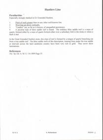
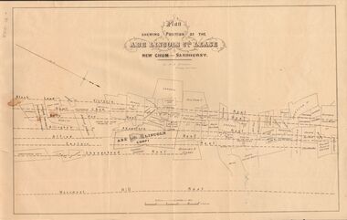 Bendigo Historical Society Inc.
Document - MARKS COLLECTION: ABE LINCOLN CO LEASE
Two copies of plan for Abe Lincoln Co. Lease, New Chum, Sandhurst. One original, one copy. On top of plan 'Plan Showing Position of the Abe Lincoln Co. Lease, New Chum, Sandhurst' under name 'by H.B. Nicholas, Mining Surveyor' Sheepshead Reef, Easter reef, Alfred Reef, Allingham Reef,Adventure Reef, Belle Vue Reef, New Chum Reef, Black Lead, Victoria Reef lines shown on map with mine leases marked. On bottom of map 'Monument Hill Reef' line marked.bendigo, mining, abe lincoln lease -
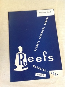 Stawell Historical Society Inc
Magazine, Stawell Technical School, Stawell Technical School Reefs Magazine 1967, 1967
End of Year Magazine for the Stawell Tecnical School 1967Royal Blue card cover with white design in lower rightStawell Technical school Reefs Magazine 1967stawell education -
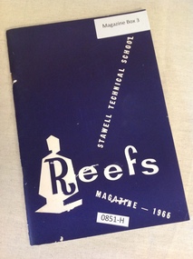 Stawell Historical Society Inc
Magazine, Mr. J. Grey, Stawell Technical School Reefs Magazine 1966, 1966
End of Year Magazine for the Stawell Technical School 1966Purple Card cover with design in lower rightStawell Technical school Reefs Magazine 1966stawell education -
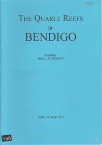 Bendigo Historical Society Inc.
Book - THE QUARTZ REEFS OF BENDIGO, 2010
A 22 page soft cover booklet 'The Quartz Reefs of Bendigo' Edited by Hugh Anderson. Contents include Victoria Reef, Diamond Hill, Glasgow Reef, Specimen Hill, Johnson's Reef and New Chum Reef. Illustrations taken from Joseph Panton's report of 1849.Hugh Anderson -
Glenelg Shire Council Cultural Collection
Postcard - Postcard - Percy Street, Portland Victoria, n.d
Black and white photo postcard. View of Percy St. from Otway St. intersection, looking southFront: 'PERCY ST. PORTLAND VICTORIA' - white script, bottom left. 'Toye photo' - bottom right Back: 'Toye Bros. Hamilton & Portland'